
Last updated: August 10, 2023.
Northern Ontario has the most extensive and richest collection of Indigenous pictograph sites in Canada. Any of the following locations would provide a great introduction to Anishinaabe rock paintings.

Quetico Provincial Park
Lake of the Woods/Rainy Lake region
Mooseland Lake
The Bloodvein R. in Woodland Caribou Provincial Park
Cliff Lake on the Pikitigushi River system
Agawa Rock
Missinaibi Lake
Little Missinaibi Lake
Diamond Lake (Temagami)
Kennedy Island (Lake Nipissing-French River)
Mazinaw Lake (Bon Echo)
Chiniguchi Lake/Matagamasi Lake
The sites I have visited and posted reports on are in blue with hot links.
___________________________
The Previous Post – Anishinaabe Pictograph Sites of the Canadian Shield – provides an overview.
This post looks specifically at sites located in Ontario.
See the Anishinaabe Rock Images folder for more posts on various provinces and states. Note that Anishinaabe (one of many spellings when transliterated into English using Roman letters) is the name by which the Algonkian-speaking Peoples know themselves. It includes the Innu, the Algonquin, the Ojibwe (aka Chippewa in the USA), and the Cree peoples. [See here for an intro to the Anishinaabe.]
___________________________
The Five Regions Covered:
The province has been divided into the following regions, with Highway 17 as the northern limit of regions 1 and 2. To directly access a particular area, just click on its name below:
-
Quetico Area
-
Lake of the Woods/Rainy Lake
-
Northwest (N of Hwy 17)
-
Northeast
-
South (of French/Mattawa Rivers)
also, see Three Essential Sources of Information

Please note – While I have visited a few of the sites mentioned in this post, for the most part I am drawing from the book sources discussed below, other material found online or at the Toronto Reference Library, and the occasional email contact.
Some site locations that you will find here are vague and, I am sure, completely wrong! It may be the nature of the source I used, or my poor interpretation of it. Over time, I hope to eliminate most of the inaccurate information.
Any specific location info – GPS co-ordinates or map-indicated – you can provide to improve this post would be appreciated. So too would any JPG images you could contribute so that others could see them. You can email me at true_north@mac.com
___________________________
Essential Sources:
Selwyn Dewdney. Indian Rock Paintings of the Great Lakes. 1962 (First Ed.) and 1967 (2nd Ed.)

Selwyn Dewdney is the man most responsible for systematically tracking down, recording, and analyzing the Anishinaabe pictographs of Ontario. By 1967 and the second edition of his book Indian Rock Paintings of the Great Lakes, he recorded 264 different sites, most in Ontario, with the others in Manitoba, Saskatchewan, and Alberta. (See here for a pdf list of those 264 sites.)
Click on the book title to see a copy of the 1962 first edition of the book, which the Royal Ontario Museum contributed to the digital Internet Archive in 2014. The first edition is available in various formats on the Amazon.ca website. See here for details.
Since the first edition covers only the first 102 of the 264 sites Dewdney eventually visited, many significant locations are not included. However, it is still a great introduction to his work. Note that the 57 pages of additional material from the 1967 second edition of the book can be accessed here as a 7 Mb pdf file.
The following fifty-year-old Dewdney maps show clearly that the heart of Ontario’s pictograph country lies from Lake Nipigon to the Manitoba border, with Quetico and Lake of the Woods being the primary locations.

Dewdney Indian Rock Paintings of the Great Lakes map – west section

Dewdney Indian Rock Paintings of the Great Lakes map – east section
————————
Grace Rajnovich. Reading Rock Art: Interpreting the Indian Rock Paintings Of The Canadian Shield. 1994.
 Dewdney spent his formative years in Kenora. Grace Rajnovich (pronounced rye-no-vich) also has a Kenora connection; she worked there for fourteen years as a field archaeologist for the Ontario government. Clearly inspired by Dewdney’s example, she writes in the foreword to Reading Rock Art that her study was meant as “a complement to that classic work.”
She provides a thematic organization to the subject matter and deepens the discussion by using the birchbark scrolls and their imagery to interpret the pictographs. (Dewdney’s work on the scrolls only happened in the late ’60s and early 1970s after his pictograph study was published.)
Rajnovich’s book also has ink illustrations of the pictographs by Ojibway artist Wayne Yerxa. In contrast to Rajnovich’s thematic arrangement, Dewdney’s discussion of the various sites is based on their geographical location. Given that he was primarily an artist, he also provided many sketches made from the side of his canoe, as well as some photographs. See here for the list of sites referred to.
Her book is available on Amazon in both hard copy ($30, Cdn) and a Kindle download ($8.).
 The Internet Archive also has a copy of her book available. A simple sign-up, and you can borrow it for one hour at a time at no cost. This Sign Up For An Account page will get you started.
————————
Thor Conway. Discovering Rock Art.2016.

Another insightful introduction to Ojibwa pictographs in Ontario is the book, whose cover is pictured here. In the 1970s, Thor and Julie Conway began their study of traditional Ojibwa culture, specifically the rock paintings found in the Ontario part of the Boreal Shield country. Over the years, they have published several articles and books on their archeological work.
Recently (fall 2016), an updated edition of Discovering Rock Art: A Personal Journey With Tribal Elders. It details a dozen sites across Ontario – from Mazinaw Rock in Bon Echo Provincial Park in eastern Ontario to Artery Lake in Woodland Caribou Provincial Park, not far from the Manitoba border. His approach is explained in the preface –
The voices of the Ojibwa elders illuminate these rock sites. By recalling oral history and legends, their knowledge helps us to understand the meanings behind the ancient carvings and paintings.
You can get a copy directly from Thor Conway or from Amazon. This Table of Contents lists the specific sites dealt with.
_______________________
1. Quetico Area

————————–
Quetico Picto Site KML File:
This Quetico Master Map with forty sites indicated will get you started on your Quetico pictograph quest. Most site locations are based on the Furtman book. Some have been confirmed or changed based on trip reports. Corrections and more precise locations that you could provide to make this map more accurate would be appreciated.
————————–
Magic On The Rocks. Michael Furtman. 2000.
It’s more than twenty years old but still the most useful book on the Quetico pictographs. Location, meaning, cultural context – Michael Furtman’s Magic On The Rocks provides the details. (Click on the title for more info.) I’ve used the Furtman book for many of the locations in this section. Read the comments on the Amazon site for reader feedback on the book.

The book is available online at the Internet Archive site. Once you sign up for a free membership, you can borrow a digital copy for 1 hour at a time. It is easy enough to take screenshots of pages you’d like to read at your leisure.

————————–
Northwoods Memories:

The Northwoods Memories website has “bulletins” of many Quetico and nearby BWCA pictograph sites. Each 4-page booklet includes the location and a brief write-up of the various images at the particular site. There was talk a few years ago of the site owner putting all the site info into book form but nothing has yet appeared. In the meanwhile, it is $5. per bulletin!
You could easily spend $50. or more if you purchased a number of these booklets before your Quetico pictograph quest. However, in the grand scheme of things –
- if they save you time
- reduce the aggravation of searching in vain for a reported site
- add to your understanding of the pictographs’ significance,
the expense is easy to justify! Put next to the cost of the fuel to get there, the Park fees, etc. and it becomes a minor investment.
See below for examples of the format and comprehensive and thoughtful coverage that the Northwoods Memories booklets provide. It is the kind of thing you might imagine that a nearby First Nation community would be interested in doing as a way of promoting a greater understanding of their ancestors’ traditional pre-Contact culture and beliefs.
————————–
Kevin Callan. A Paddler’s Guide to Quetico and Beyond.

This excellent collection of northwestern Ontario canoe trip reports has several references to pictograph sites scattered throughout the book. Like the Furtman book, a digital copy of Quetico and Beyond is available for an hour at a time from the Internet Archive website after a simple and free sign-up. See here.
————————–
Quetico Foundation

The current Quetico Foundation website has this statement about the pictograph sites found in the park:
Indigenous peoples have lived in this region for thousands of years. In fact, 28 Indigenous pictograph sites can still be sighted in the Park. For many Anishinaabe at Lac La Croix, these pictographs and their locations are sacred. To protect and respect this land, we’re deeply honoured to work with and learn from the Lac La Croix First Nation. [Source]
To show that it is “deeply honoured to work with and learn from the Lac La Croix First Nation,” the Foundation has removed all locations of the pictograph sites from the maps and any images of the pictographs from their website. However, this gesture of goodwill is not made clear anywhere on the current version of its website. Sharing what it has learned from the “knowledge keepers” of the F.N would also enrich the wider public.
Selwyn Dewdney began his twenty-year quest for pictographs in Quetico in 1957. He was able to spend time with Charlie Ottertail, an elder at what is now called Lac La Croix First Nation. As he described the encounter –
The Neguagon Reserve on Lac la Croix, just west and south of Quetico Park, is only a few miles north of the pictographs on the big “Painted Rock.” There I interviewed Charlie Ottertail, one of the few older Indians who still cherished his ancestors’ ways and beliefs. The sun had set and the light was dim inside the Ottertail cabin. “A small dark room,” to quote from my diary, “the frailbut still vital Indian on the floor under a grey blanket, rising on one elbow to speak, sinking back between speeches … a lean intelligent face.”Yet there was little he knew about the pictographs : only that he was sure they had been there when the treaty of 1873 was signed. [Dewdney, p.24]
————————–
Friends of Quetico
Meanwhile, Friends of Quetico has a Pictographs of Quetico booklet which provides details on the sites and their locations. Click on the title above or the booklet cover below for ordering info – the cost is $3.50. + shipping ($5.!). The booklet may be available at the Park Entrance Building.

————————–
Chrismar’s Quetico Provincial Park and Area
 This 1:125,000 waterproof map was adopted by Quetico Park as its official map and includes information wilderness canoe trippers will need to plan their Quetico route. My copy was published in 2014; there may be a newer edition. The Chrismar map is more accurate for portage info than the McKenzie or Fisher maps. While portages are indicated, campsites are not. Also not shown are pictograph locations, though a list of some twenty lakes with sites on them is included on the back side of the map. So too are these bits of advice:
- Do not touch pictographs under any circumstances.
- Treat these places with respect and reverence
- and enjoy your search for them.
The Chrismar recommendation for pictographs is to see the Pictographs of Quetico booklet mentioned above for the locations.

The Paddle Planner website is helpful if you would like to see campsite options as you plan your tour of the Quetico pictograph sites. Here is a view of their online map with a Canada Topo background –

As with the Chrismar map, picto locations are not indicated.
————————–
Park Map

map source in Quetico Provincial Park Management Plan (2018)
————————–
Agnes Lake
See here for detailed maps & discussion of 7 different sites at the Northwoods Memories website.
Dewdney began his pictograph quest by recording his first two sites on this Lake in 1957. Read his account in Indian Rock Paintings here.

Let me know how far off I am on any of these seven sites!


Agnes Lake Site 2 (island) – canoe with two human figures
The Northwoods Memories website has pamphlets on the following seven Agnes Lake sites-


—————–
“Ahsin” Lake – Dewdney’s name for Payne Lake in Quetico Provincial Park. See Payne Lake below for more details.
—————–
Basswood River
—————–
Beatty Portage – Lac la Croix west end on the Minnesota side < 1 km N of portage
—————–
Beaverhouse Lake
- map
- Dewdney makes no mention of this lake in his book.
- Furtman notes that one site consists of four separate panels spread over 100 m.
- Northwoods Memories does not have a bulletin on the lake, but the site owner/writer, Bob Evans, makes this comment about a multicoloured image on the lake.
—————–
Burt Lake
- Map
- Dewdney makes a brief mention of this site, the 9th in his search. he notes handprints and other faded “material”
- Furtman has a brief look at this site.
—————–
Cirrus Lake
- map with one site at the east end of the lake
- Dewdney – no mention in either Edition of IRPGL
- Furtman – saw “four irregularly shaped dots with a wash of red just to their left” but not the other images reported in the Friends of Quetico Park book
—————–
Darkwater Lake (formerly Darky Lake) in Quetico P.P.
- map with Dewdney commentary on the two sites.
- Conway’s Discovering Rock Art (2016) includes a chapter on this lake.
- Dewdney’s Indian Rock Paintings extract (pp.32-34 + 106 of 2nd . Ed.)

Dewdney drawing

Dewdney drawing of picto face with a two-horned snake figure with canoes and moose

a 1957 Dewdney sketch of a couple of the Darkwater Lake Pictographs
See here for the Northwoods Memories booklet on the two sites.
—————–
Darky Lake – renamed Darkwater Lake.
—————–
Doré Lake
- map of the lake with the site located at the SW corner of the lake. Map source: Paddle Planner indicates nearby campsites and portages to reach the lake.
- Dewdney does not mention it in his 1962 book
- Furtman notes that “two faded indistinct are reported at this site”
- Northwoods Memories does not have a booklet dedicated to this site.
—————–
Kahshahpiwi Lake –
- map
- Furtman notes one site at the south end of the SW arm of the lake
- The Northwoods Memories website has a booklet available on this lake’s pictographs.
- Dewdney makes no mention of this lake’s picto site.
—————–
Kawnipi Lake
Bog Evans and Edwina Trout, the owners and content creators of the Northwoods Memories website, list 5 sites on this lake and have a booklet available on this lake’s pictographs. See here. Their work-in-progress (no apparent new entries since 2011) Encyclopedia also has an entry on the lake and its rock paintings.
- Kawa Bay – 3 sites
- McKenzie Bay – 1 site
- McVicar Bay -1 site
Kawa Bay (Kawnipi Lake) –
map of two locations at the mouth of Kawa Bay- a northerly site on the west side of the bay’s mouth, another on the east side of the mouth
Kevin Callan’s Quetico and Beyond (2006) has a brief account of the location and pictographs of two Kawa Bay sites. In 2009, a third site was discovered.
The rest of the day was spent paddling effortlessly along the shoreline of Kawnipi Lake, finally moving over to the western shore to check out the two pictograph sites at the entrance to Kawa Bay. The first painting is near the southern entrance to bay, and the second is near the northern entrance. Of the two sites, only the first is easily recognizable. The second, believed to be of Missepishu (the Great Lynx), is far too faded. We located the first panel directly below an obvious crack in the rock face. The pictograph portrayed two (possibly three) Maymaygwayshi sitting in a canoe. The figures had what seemed to be horns on their heads and were sitting in the canoe with their arms bent at their waists.
Furtman has five pages of coverage on the Kawa Bay sites.
——
McKenzie Bay (Kawnipi Lake)
——
Northwestern Site (Kawnipi Lake)
To quote Evans/Trout at the Northwoods Memories site:
This site was first reported to us by Chris Stromberg, a park ranger, in 2008. It is in a narrows north and west of Rose Island and Kasie Island. It shows handprints and perhaps some abstract images, but these abstracts may actually be geologic coloring and not pictographs at all.
——
McVicar Bay (Kawnipi Lake)
The site is at the south end of the bay and not on the water’s edge
—————-
Keewatin Lake
- Dewdney: “The next day we found our fourth site on the little unnamed lake between Agnes and Kawnipi.” It was 1957, and Dewdney was at the start of his picto quest. With him was his oldest son, whose name is Keewatin!
- Furtman identifies thunderbird figures and also challenges the old centaur i.d. of what computer analysis shows to be two separate figures – a moose and a cross
- See here for the Northwoods Memories booklet on the two sites.
—————–
Lac La Croix –
The international border runs down the lake’s 40 km length. The Lac La Croix First Nation territory stretches across the north side of the lake, which is not included in Quetico Park. Motorized boats are allowed. The Quetico Park website also notes that Lac La Croix Nation members are allowed to use outboard motors on selected other lakes for traditional harvesting and guiding services.

There are two sites on the lake, one at the west end (N of Beatty Portage) and one at the east end. For W end site, see below.
Of the east end site, Selwyn Dewdney made the following comment –

He devotes a few pages (see here ) to the site in his book. Included are a few sketches of individual images and various faces. One of them is a collection that he labelled “The Warrior Group.” It was a name he came up with thanks to the human figure holding a bow or spear.
Dewdney on Lac La Croix Pictograph site 
Another drawing is of the rock face with the many hands, a fox figure and massive smearing.

——————-
Of the Lac La Croix site, the Northwoods Memories three-booklet set notes this:
The well-known Picture Rock has six panels of images
and another cliff just to the north of it has another two
panels. There are so many images that these two cliffs
are presented in a set of three bulletins.
See here for the summaries on each of the three booklets.
Given the distance between the northern two panels and the six to the south, some sources (e.g. Furtman) refer to them as two separate sites.
—————-
Kevin Callan, aka The Happy Camper, has an article on Explore magazine’s website (Mar 2, 2020) that briefly discusses the Lac La Croix pictographs. See here for his write-up: Lake of the Woods Lac la Croix. To locate the lake in Lake of the Woods seems a bit strange; it is 175 kilometres east of the Lac des Bois and on the western edge of Quetico.
Included in his brief piece are two images of one of the many panels of a site that sounds like a must-visit! However, neither image is of a Lac La Croix site. Both are of the famous shaman and bison panel at the Artery Lake site on the Bloodvein River in Woodland Caribou Park!
——–
Lac La Croix – west end site. Not in Quetico Park, but on the US side in BWCA
The map shows the location just north of the Beatty Portage
Furtman provides a map and insightful discussion of the site’s images, which he notes are quite faded but contain some very fascinating figures.”
—————–
McKenzie Lake –
- map showing the locations of two sites (three pictographs at each site)
- info on the Northwoods Memories booklet of the two sites here
- no sites on the lake were mentioned by Dewdney in the first edition of his book. In the 1967 2nd. Edition, he notes that one had been confirmed and pin-pointed” though he does not include any details on the one site.
—————–
Mack Lake –
pictographs were first reported in 1987
—————–
Montgomery Creek –
- map for the location of the creek, which is usually dried up. It will probably be a hike up the west side of the creek to the picto site. after passing around or over two likely imposing but pictograph-free cliff faces, you come to a smaller cliff.
- Furtman found two grouping of images here, separated by about 50 meters.What you’ll see: caribou figures, one in outline and the other solid coloured. Also, Furtman’s post-visit computer analysis shows a human figure shooting a bow.
—————–
Montgomery Lake –
- a map with three campsites indicated.
- The pictograph site is by the campsite on the east side of the V-shaped island. Furtman has five pages on the Montgomery Lake and Creek picto sites. He includes this image from the lake site:

- In Quetico and Beyond, Callan writes:…we spotted a rarely viewed pictograph directly below our campsite on Montgomery Lake (the painting, which is of a male stick-figure with an erect penis, was discovered in 1984 by David Ingebrigtsen).
—————–
McAlpine Lake
- map with picto location and nearby campsites and portages indicated
- Furtman (pp.63-66 )has a brief section on the one pictograph site on the north side of the lake. Of the pictographs, he notes that they are abstracts, somewhat faded, and among the most intriguing anywhere.
- Dewdney did not get to this lake in his search, and while Bob Evans/Edwina Trout may have their Northwoods Memories site does not list a booklet for this lake.
—————–
Namakan Lake (Narrows at east end of Namakan Lake). Not In Quetico P.P. but just west of the boundary of Quetico on the Ontario side of the narrows.
*Dewdney visited the area in 1958 and recorded three sites. Indian Rock Paintings has a brief discussion of what he found. See here.
*Furtman has a few pages (see here – pp.127-1300 on the three sites in the Narrows. The info below comes from his book.
There are three reported sites. Furtman details the two at the south end of the narrows. He notes the rare use of white pigment at the more northerly site. (Nearby site on Beaver House Lake also has a pictograph with white pigment; The “Moose and Stars Panel” at Fairy Point on Lake Missinaibi is another site where white “paint” was used.)

One of the white-coloured pictographs (a moose figure) from this site was on a slab of rock hauled away by Arthur Pohlman and his brother-in-law and seen by Dewdney by his garage! He had the rock shipped to the ROM in Toronto.
Dewdney also reported a site at the north end of the narrows with three images (human; headless moose; small animal.
*Northwoods Memories has a booklet on the Namahan site. Included is coverage of King Williams Narrows.
—————–
Northern Light Lake (Trafalgar Bay) – image here and here; 1:30,000 topo here
Read Dewdney’s brief account of his 1958 visit here. It includes these two drawings –


—————–
Payne Lake – the location of Dewdney’s “Ahsin” Lake, the 3rd picto site he recorded after the first two on Agnes Lake. Indian Rock Paintings… has this account:
With two sites figuratively under our belts we set out hopefully for Williams Lake. This was the most definite report on our list. We had even seen photographs of the paintings. All reports but one agreed that they were on a sizable cliff at the west end. The exception placed it on a neighbouring unnamed lake. As the reader will have guessed we found that the minority report was right. Here we recorded three thunderbirds, a canoe, two simple abstractions, and a weird little moose.
See here for the Northwoods Memories website write-up on this lake’s site.
—————–
Pictured Lake – also see the front cover of Dewdney’s book! Standing figures in a canoe and the two-horned snake Mishi-Ginebig and other smudges and difficult-to-read images.

Painted Rock Lake – See here for the image source.
Note: The above link to a Thunderbay Field Naturalists web page where I found the above image is dead in mid-2023. The write-up on Pictured Lake makes no mention of the pictograph site on the lake. While it notes that “the property is not road accessible and this has been key to protecting both cultural and natural heritage features of the site”, readers are left in the dark about what material aspect of cultural heritage – and whose – is being protected.

A stunning watercolour painting by Steve Emms, a Thunder Bay photographer/painter, gives a more complete view of the pictograph site. Check out his website here for more of his work.

source of image – fineartamerica.com
—————–
Quetico Lake
The cliffs of Quetico Lake are some of the most richly adorned rock surface of the entire canoe country. The four known sites along its north shore often referred to as the Quetico Lake Gallery. [Furtman, 48]
map with four sites located on the north shore of the northern arm of the lake
Dewdney recorded two sites on Quetico Lake in 1959 and did this sketch of Site #1 (#72 on his list of 266 sites here would eventually visit)

Furtman (54-60) provides exact location information and a description of the images at each site. Of Site #1, he writes: “One of the best displays in the Quetico (sic), this densely packed grouping has at least nine recognizable symbols, and much red wash, all on one panel.”
Callan has a brief entry on the Quetico Lake picto sites. It begins with – “What an incredible place!”

—————–
Saganaga Lake – Cache Bay Site.
the location indicated on this map.

—————–
Shade Lake – The site is located at the top of the narrow bay on the NW side of the lake. The Northern Memories website has a booklet dedicated to this site – location and details about the images. See here for more info.

—————–
Swartman Lake
—————–
Ted Lake
—————–
Trant Lake
map with portages into the lake, campsite locations, and the one picto site indicated
Kevin Callan in Quetico and Beyond provides the following summary of the site –
I spent a good hour at the bottom end of Trant Lake looking for the Native pictographs reported to be here. I finally spotted them near the base of a high cliff along the western shore, directly beside the bay where the portage comes into Trant Lake, a totally different location than suggested in my park booklet. The booklet also noted that a canoe with two paddlers and three moose could be discerned in the pictograph. But, to me, one of the moose resembled a snowshoe hare and another had straight antlers, which made it look more like a young elk.
Furtman has a couple of pages on the Trant Lake site.
The Northwoods Memories website has the following description of its Trant Lake bulletin –

—————–
Wolseley Lake
______________________________
2. Lake of the Woods/Rainy Lake

Annie Island – Lake of the Woods (Whitefish Bay). There is a lone human figure described by Dewdney this way – “the sole but fascinating pictograph on a beautiful granite wall: a vertical zigzag of finger-width colour that ended in the head of a Maymaygwayshi.” See Rajnovich for a brief discussion of the pictograph –pp.14, 57,92,137 of Reading Rock Art
—————–
Blindfold Lake – Lake of the Woods (12 km SE of Kenora). See this 1.3 Mb pdf file for basic information and a map.

Blindfold Lake Pictograph

Dewdney photo from 1958 – p. 27 of 1st Ed._
—————–
Burditt Lake (aka Clearwater) – see Rajnovich pp. 92-97 for discussion. The exact location yet to be determined. See here for a brief Dewdney discussion of the site and examples of images.
—————–

Cliff Island (Lake of the Woods) – north side of Sunset Channel/about 30 kilometers from Sioux Narrows. The exact location has not yet been determined – the western end on the south side of the island seems most likely. A rabbit man, an animal figure, and other images and markings. Dewdney also mentions a petroglyph site 1/2 mile east of the rock painting site.
—————–
Crowrock Inlet – 25 meters of pictographs, mostly smears along a rock face. More info here
—————–
Cuttle Lake: two sites – a larger one and a small one about 300 m south Ontario Archaeology Arch Notes article (pages 6 to 9 ) accessible here has a detailed discussion by Rajnovich.

Cuttle Lake Pictographs

Dewdney photo from 1958 p.61 of IRPGL
—————–
Devil’s Gap Lake in Turtle Lake Provincial Park – a part of the Turtle River canoe route – has a “great set of pictographs,” according to Backroads Bill (Bill Steer). While the lake name does not appear in Federal Government topos or on the Ontario Gov’t topo site, it may be a name used by locals. Nearby is what Steer calls a dolmen stone. See his article here.
—————–
Dryberry Lake Dewdney recorded two sites on the Lake. Dewdney devotes a page of Indian Rock Paintings of the Great Lakes to a discussion and drawing of what he found.

William McInnes of the Geological Survey of Canada visited the site in 1896 and made the following sketch –

—————–
Ignace-area: unnamed Lake – the Smyk site and another. See here for Ontario Archaeological Society’s Arch Notes Sept/Oct 2014 pp 10-11 for Dennis Smyk’s brief report and photo Google map of the Ignace area and its 1000 lakes here. Smyk has apparently located some 150 pictograph sites in the Ignace area over the years.
—————–
Jackfish Lake – 1:50,000 topo map of the Lake here; picto on one of the Lake’s islands. See here for a 2.5 Mb pdf file with images. For Dewdney’s text, see here.
—————–
Lower Manitou Narrows (Lower Manitou Lake)

Dewdney photo from 1958
While Dewdney was an artist by training and inclination, William McInnes worked as a geologist for the Geological Survey of Canada. The different perspectives – and the 70-year cultural time gap when they did their sketches – resulted in different treatments. Below is the 1890 McInnes drawing of what he recorded –

—————–
Painted Rock Island – Google map showing where it is in relation to Sioux Narrows here; also, more on location and pic here; also here
—————–
Picture Rock Point/Western Peninsula (Lake of the Woods) – Dewdney mentions a humble rock painting site found on one of the 100+ points of the Western Peninsula. His name is Picture Rock Point, which does not appear on the topos. The pictographs, he writes, are “painted on a thick, rough encrustation of lime, and, except for the human figure, are obscure.” Location – undetermined!
—————–
Portage Bay (Lake of the Woods) – site briefly mentioned by Dewdney -“the equally modest site at Portage Bay, a few miles west of Western Peninsula.” There is another Portage Bay at the north end of the Lake at Keewatin.
—————–
Pukamo Island (Rainy Lake) Rajnovich paper p. 26-31 with drawings; map here; also a photo.
—————–
Sabaskong Bay
—————–
Silver Lake
—————–
Teggau Lake (Kenora) – some pix here
—————–
Whitefish Bay – At least a half-dozen sites are recorded in this area. Dewdney’s Indian Rock Paintings of the Great Lakes (pp. 40-53) provides some detail on them, as well as on those just to the west and north of the Aulneau Peninsula. See here for the Dewdney text.
—————–
Whitefish Bay “Hula-Girl” Island Site – Identified as the “Sioux Narrows” site by Dewdney, it faces west at the northern end of an unnamed island locally called Hula-Girl about two miles south of Sioux Point. See here for Dewdney’s discussion of the site he listed as #28.

—————–

See here for the image source at the Tomahawk Resort website
Also, see this Tomahawk Resort post for a couple of pix of the site in wintertime. A reader sent in the exact GPS coordinates – see the Google map here.
—————–
Winnipeg River (near Eagle Bay Road in Kenora) – location here.
—————–
White Otter Lake -See here for the Natural Resources Canada 1:50000 topo 052G04 White Otter Lake.
The Toronto Public Library system’s Central Reference Library has one copy of Jaqueline Rusak’s brief study titled “The White Otter Lake Pictograph Project:1991 Results”.
A positive review of Rusak’s work in Ontario Archaeology Notes (1993-1) by Andrew Hinchelwood is accessible online here.
An email from someone who attempted to locate the various sites using the study was much less enthusiastic. Locations, distances, and site descriptions were apparently often unreliable.
Before finding her study, I had never heard of White Otter as a pictograph site; I used it to locate the 24 White Otter Lake sites she mentions on the above Garmin Topo Canada map. The email correspondence mentioned above prompted me to reduce the sites to two on Anne Bay, supposedly two of the best, and several on the west side of Big Island. Also noted was his opinion that the Turtle River Park pictograph sites not on the Lake were more impressive.
The 2012 Turtle River-White Otter Lake Park Management Plan refers to Rusak’s study when noting that the park “has documented 39 archaeological sites, 37 pictograph sites (Rusak 1992)”.
______________________________
3 Northwestern Region
the lakes and rivers north of Highway 17 from the Manitoba border to Wawa.
Aegean Lake (WCPP) – There is one site on this lake as reported by Kevin Callan in his Quetico and Beyond book (Ch. 12 –Woodland Caribou Sampler Route). It is at the south end of a rather convoluted lake – see this map! It is labelled South Aegean Lake on his trip map. Callan’s description of the location –
Travel south and then east toward Paull Lake. There are campsites at the end of the long peninsula on both sides of the narrows. Be sure to visit the pictograph here…
This map indicates campsites on a long peninsula. The picto site is near the campsite. No mention is made of what is there. Note the Red Lake 3 fire perimeter from 2016, which has burned the south end of the lake and the three portages that get you into Paull Lake.
—————–
Albany River (Petawanga Lake) – see here for Dewdney, p. 124 for a photo – no exact location is given. We paddled down the long Lake, unaware of the site’s existence and which side it was on.
—————–
Allanwater River (N of Termite Lake) (Wabakimi) – see here for a map with the location.

Allanwater River pictograph – caribou
—————–
Barbara Lake– see Dewdney analysis and sketches here (p. 141-142 of Indian Rock Paintings – 2nd. Ed.). Included is this image of what may be a couple of Mishipeshu figures – Dewdney on Barbara Lake picto site – pp.141-142 of 2nd Ed. 
—————–
Bloodvein River – 16 sites in Ontario and Manitoba
Artery Lake – Conway’s Discovering Rock Art (2016) includes a chapter on the main Artery Lake site.
See the following post for lots of images and discussion. We visited in 2014.
Pictographs On The Bloodvein: The Artery Lake Site

Artery Lake shaman – at the main site

Bloodvein River – Dewdney drawings of pictographs at main Artery Lake site
A Google Books chapter (pp.127-133, with one page missing) from Hap Wilson’s Trails and Tribulations in which he provides a true believer’s approach to the pictographs.

a minor unrecorded picto site on Artery Lake
The two major Bloodvein sites in Ontario are covered in the two following posts –
Pictographs On The Bloodvein: The Murdock-Larus Site
Pictographs On The Bloodvein: The Artery Lake Site
Bloodvein River (sites from Barclay Lake to Artery Lake) – a map with six sites
Artery Lake (North Arm) – a minor site with a couple of fading pictographs. Dewdney notes this about the site –


pictograph site on Artery Lake – north arm
We did not see the “black sauromorph nearby”!
—————–

Bloodvein River between Murdock and Larus …shaman holding infant (or otter skin medicine bag?)
Murdock Lake – a part of the Bloodvein River system. Two sites – one at the east end of the Lake, the other about 1.5 km West from the north end of the Lake on the way to Larus Lake. See here for the minor site and here for the very large one. A fellow blogger also has a couple of pix here.

Minor Murdock Lake picto site – four images: slash marks, canoe, stick figure animal, fish.
—————–
Bluffy Lake – Dewdney: “…includes a turtle, a partly disfigured deer, and two tally marks.”
—————–
Cliff Lake (Pikitigushi River) –
Do not confuse this Cliff lake for the Cliff Lake in Kenora District, something Dewdney did for a decade before realizing his mistake.
See here (pp. 135-141) for Dewdney’s discussion & drawings.
Cliff Lake is also mentioned in this myccr post on Wabakimi pictograph locations.
See my posts on the Cliff Lake Pictographs – two from 2013 and two from 2018.
- The Pictographs of Wabakimi’s Cliff Lake -Part One: Selwyn Dewdney Takes Us on A Tour
- The Pictographs of Wabakimi’s Cliff Lake – Part Two
- From Cliff Lake To Lake Nipigon: Logistics Maps, and Day 1 – Cliff Lake
- From Cliff Lake To Lake Nipigon: Days 2 & 3 – From Cliff Lake to The Bear Camp


Dewdney’s site 119 on Cliff Lake – the moose image and smudges
—————–
Cochrane River (north of Deer Lake) –
Dewdney discussed his findings here. He includes these two images –


—————–
Deer Lake (McIntosh Bay)
- rabbit (?) picto and “several weathered abstractions.”


—————–
Dog River (mouth of) (Lake Superior)
—————–
—————–
Donnelly River– 2 sites.
Dewdney: “a major group of paintings…with a smaller site less than a mile away. The paintings appear at the foot of modest rock walls…”
See here for nearby North Caribou Lake cultural landmarks
—————–
Echo Rock (Lake Nipigon) – see below for Lake Nipigon.
—————–
English River (north of Arabi Creek) – See here for the location and drawing of the site.
—————–
Frances Lake (Dogskin River system) – Dewdney discussion and 1964 photo from Indian Rock Paintings of the Great Lakes

—————–
Hansen Lake (Woodland Caribou PP):
- Two sites on the lake were visited by Kevin Callan,” one at the north end near the outlet and one to the southwest on the way to the 100-rod (546 yd/500 m) portage leading toward Wrist Lake.” See here for his account of the mystical experience he and his wife experienced at the site on the SW corner of the lake.
- Dewdney’s write-up only notes one site and includes sketches and the following 1964 overview photo of the site –

Of the pictographs at the site, Dewdney mentions a deer-like animal with a faint human figure above it and, on another face, what looks like a human figure with a snare or a line of supernatural power partly encircling a caribou.
—————–
Harmon Lake (Wabakimi) Brightsand River system See here for source & location info of the above site on the north side of the bay. Dewdney would later visit the site and include it (site #151) in his book’s second edition (1967). No info yet on the site indicated on the opposite shore.

—————–
Heathcote Lake (Wabakimi) – exact location not known
—————–
Indian Lake: Just east of Mameigwess Lake. See Dewdney’s brief mention and drawings here.
—————–
Lake Nipigon:
Echo Rock – the site is just north of Gull or Kaiashk Bay on the west side of the Lake. It is a towering rock face visible from some distance away.

Echo Rock from the northern tip of Kelvin Island
An overview map and a 1:50000 topo view . This aerial photo of the rock face includes the surrounding Undercliff Mountain.
Scroll to Dewdney p 78 for an account of his visit to the Echo Rock site. Dewdney may have been alerted to the presence of pictographs by a sketch included in a report by William McInnes of the Geological Survey of Canada, who drew the following in 1894 –

We paddled by Echo Rock in September 2018. The following post describes our time looking for pictographs. We saw lots of lichen and graffiti – the worst we’ve ever seen – but no pictographs on Echo Rock!
Paddling From Lake Nipigon’s Echo Rock To Waweig Lake

graffiti at Echo Rock on Lake Nipigon – but no sign of the pictograph!
—————–
Gull (or Kaiashk) Bay– see Dewdney p. 78-79 here and map here

William McInnes of the Geological Survey of Canada paddled by the site in 1894 and made this sketch of some of the images he saw –

In a Down the Gull River Canoe Trip report, Vern Fish mentions visiting one of the sites in Kaiashk Bay and finding graffiti marring the site. He included the following image –

We had a similar experience at the Echo Rock site just north of Kaiashk Bay.
—————–
Orient Bay – see here for the pdf file with a map and quotes from Dewdney and Morrisseau about the site.
—————–
Lake Superior
See NE Section below for info on Agawa Rock and Devil’s Warehouse Island
Nipigon Bay – on the east point across from Red Rock – map here.


Memekweshik. Norval Morrisseau 1974

maymaygweshi image –
Maymaygweshiwuk – mythical creatures (small and hairy) associated with rock painting sites and credited for the actual paintings by some Anishinaabe elders. They were believed to live within the rock face itself, and shamans would petition them for requests of medicine, special knowledge, or other favours See here for more information.
—————–
Lake Superior (Worthington Bay) – pictograph image here -trail info here
—————–
Lac Seul:
With the construction of the Ear Falls hydro dam (1929-1933), the Lake became a reservoir, and the 700 or so Treaty #3 Ojibwe inhabitants of the Reserve saw a fifth of their lands flooded (Toronto Star article 2021).
Dewdney includes this paragraph in his Indian Rock Paintings of the Great Lakes –
Before it was flooded Lac Seul was one of the paradise lakes of the north, with countless sandy beaches, great stands of white pine, winding creeks, and lush swamps where the wild rice grew thick and thousands of ducks bred. Here were endless miles of browsing for moose, and latterly deer, with depths where great sturgeon and fat lake trout lurked. With the flooding at least five pictograph sites disappeared; and the only clue to what they were like is in the peripheral ones. The Old Copper people were here, and who knows what other wanderers before them. Archaeologically, the surface has barely been scratched. (p.66. 1st Ed.)
In 1991, the Lac Seul First Nation was granted $30,000,000 in compensation after taking the government to court. The F.N. demand for a more equitable settlement remains an issue in 2021.
—————–
Mackay Lake– top of the Little Steel River system mentioned by Dewdney as a possibility – no confirmation as of yet
—————–
Mameigwess Lake: The Lake’s name is one of many transliterations of the Ojibwe meymeygweshi, the fairy-like beings who live in the rock face frequented by the shamans. Selwyn Dewdney discusses the Lake on pages 67-69 of his book Indian Rock Paintings. The pictographs are on a small point in the southwest bay of the Lake.

Mameigwess Lake, William McInnes sketch done in 1898
[Note: there is another Kenora District Mameigwess Lake which feeds into the Winisk River system.] On some 1970s MNR material, the name Orangatang is included in brackets. Dewdney mentions the lake name Rangatang in connection with Mameigwess.
—————–
Mooseland Lake: Bill Steer has the definitive article – All about a bush-whacking, canoe-dragging, fifth-time’s-a-charm backwaterway journey. A Google interactive map is included showing you how to get there and where to look. Some 24 different sites or panels were initially recorded by Dennis Smyk.
Along with Cliff Lake on the Pikitigushi River system, it is the most impressive rock-painting site in northern Ontario. Fairy Point on Lake Missinaibi is another site that rates a mention as a significant site.
—————–
Misehkow River – There is a pictograph site (a canoe image and a couple of other morphs) on Rockcliff Lake. The exact location is unclear, but it is on the west side of the lake. See my post on the Misehkow River for more info.
—————–
Moberley Lake (Brightsand River system) – See here for info source and drawing.
—————–
Musclow Lake (off the Bloodvein River system via Barclay Bay) The Dewdney sketch of the one pictograph at the site is from his Indian Rock Paintings. [2nd. Ed. p.121]

—————–
Northern Twin Lake
—————–
Palisade River (Wabakimi) – where the Slim River joins. There is indeed a rock face  there, but we paddled right by three times in 2012, not even knowing there was a pictograph or two. The experience was one of my motivations for starting this series of pictograph posts the next year!
See here for a map of four reported pictograph sites near the mouth of the river.
If you find the images on that rock face, send me a jpg of what we missed, and I’ll post it here (if you don’t mind!) Maybe that orange on the rock face on the left side of the image below is iron oxide!

paddling past the stretch of vertical rock on one side of the Palisade River
—————–
Picture Paint Lake (Kenora) – Dewdney: “Only a few smearings and vestigial abstractions”
—————–
Pine Needle Lake – see here for a couple of pix. Dewdney describes his attempt to find this site in the 1967 2nd edition of Indian Rock Paintings of the Great Lakes (See here for his account).

Pine Needle Lake Pictograph panel

Dewdney sketch of Pine Needle Lake Rock Face
—————–
Red Lake – click on the title for map view; see here for my brief write-up and some photos.

Red Lake picto site
—————–
Rex Lake ( site on a little sliver of a lake west of it)
—————–
Rockcliff Lake – see Misehkow River
Sharpstone Lake –
map here. Dewdney discusses the site here.
—————–
Shikag River –
see here for David P. Rogers/Ontario Archaeology source of info.

—————–
Roderick Lake – two sites with six small pictos (See Dewdney 115 for details & sketches)
—————–
Telescope Lake – Onnie Lake (nameless Lake in between the two)
—————–
Terrier Lake – exact location unknown; map and Dewdney’s comment
—————–
Wabaskang Lake is just west of Perrault Falls on the road to Red Lake. The precise location of pictograph(s) is not indicated.
—————–
Winnipeg River (near Eagle Bay Road in Kenora) – location here
—————–
Worthington Bay – see Lake Superior (Worthington Bay for info and map)
—————–
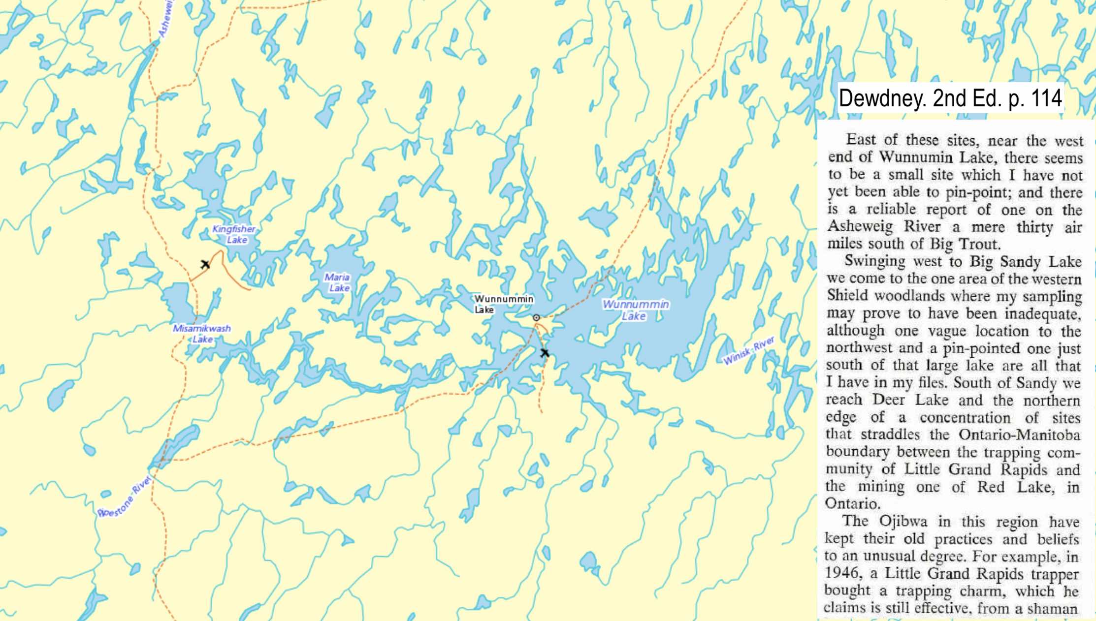
Wunnumin Lake – article in Ontario Archaeology by Andrew Hinshelwood on archeological work on the Lake here.
Lower Wabakimi Lake – site mentioned in Reid/Grand Canoeing Ontario’s Rivers
precise location yet to be determined
______________________________
4 Northeastern Region
Alma Lake – Algoma District – see map here. The exact location is not determined but is most likely at the west end of the Lake. One pictograph is of a crane footprint, a symbol for one of the five major doodems (totems) or kinship groupings in Ojibwe society.
——————
Anima-Nipissing Lake (Temagami) – six sites in all. Four sites are identified on Jeff’s Temagami map.
From north to south, they are named:
- Anima-Nipissing (ChGx-1) – 3 separate faces or panels, canoe image among them
- Shady Grove Picto Site (ChGx-2)
- Whitewater Portage (ChGx-3). Zawadska:
The dome -shaped cliff stands out sharply from the surrounding shore, which is overgrown by trees and bushes. Here as well the images are painted on a lighter -coloured cliff that is streaked with white precipitate deposits.
- Greyrock (ChGx-4)
Also, sites reported in
- 5 Crow Rock Bay, N of Site #1, discovered in 2009
- 6 Windy Arm, N of Site #3…Zawadska notes that “four oblique lines are depicted.”
The exact locations of 5 and 6 have not yet been confirmed.
——————
Bigfour Lake – a reported site but exact location not yet determined
——————
Bolkow Lake (Missinaibi area) – See the Minisaabik website for more context, the roughly indicated location, and eight images. [The site is dead as of mid-2023.]
——————
Chiblow Lake – Algoma District – see here for a map of the Lake and its surroundings. The exact location(s) has yet to be determined – lots of vertical shoreline rock to check out!
——————
Chiniguchi Lake – map; Ottertooth map reference- “rediscovered in 2008.”
——————
Collins Inlet (north side of Phillip Edward Island) – two Thunderbirds, a war canoe, and more In June 2016, we visited the site.
See The Ojibwe Rock Paintings of Killarney’s Collins Inlet for more pix, another map, and a detailed discussion.

——————
Diamond Lake
- the largest pictograph site in Temagami country.
In October 2014, my brother and I revisited the site. The following report has some historical background and analysis, as well as lots of photos.

Diamond Lake Pictograph Site

Diamond Lake – moose and vertical lines

Diamond Lake Pictographs – northernmost grouping
——————
Dog Lake (near Missanabie) –
26 images, some very faint, on 8 panels: many “tally marks,” thunderbirds, crosses, moose, a canoe, and figures with bowed legs.
——————
Ferris Lake
(formerly known as Little Hawk Lake) – brief mention by Dewdney. Also mentioned in a post on the Little Hawk Portages. The site is located at the SE corner of the Lake – see the map here.

one of the Ferris Lake pictograph panels
——————
French River
Selwyn Dewdney recorded three sites on the river in the late 1950s. Ordered from north to south, They were:
- the “Gibraltar” Point site,
- the Kennedy Island site,
- the site just above Recollet Falls.
Thor Conway, in the 1980s, noted that there were eight sites on the river. They include the site he registered
- the Keso Point site (i.e. the one at Cradle Rapids) and
- the site just north of the old Hwy. 69 bridge
The Kennedy Island site is the most extensive of the various sites. The other sites host a solitary almost-gone drawing.
Yet to be determined are the other three sites Conway had in mind. There are also late 1700s-early 1800s accounts in the voyageur literature of lichenograph sites in the Ox Bay area, but they have disappeared as the lichen has grown back over the scraped-out spaces.
See this extract from John MacDonnell’s diary for an example. Note that he does confuse the issue by conflating scratching the image out of the lichen with painting it with”some kind of red paint.” He may have two different sites in mind, one with pictographs and the other with lichenographs.
French River – Gibraltar Point.
Dewdney writes this about the site:
The paintings on “Gibraltar,” as it is called locally, are badly weathered, and little can be deciphered but a few canoes.
In a mid-80s paper, Nick Adams noted that the site had been defaced by graffiti. Once visible were four canoe images, a stick figure, and other undecipherable and weathered morphs. We looked but did not see what Dewdney saw some 60 years ago. The video below is a short clip of us paddling past “Gibraltar”…
————–
See here for an early 1980s paper by Nick Adams and the source of the drawing below.


Dewdney drawing of the Kennedy I pictos
Dewdney has a short summary of the Kennedy Island site:
Site #80, a bare half mile west of Keystone Lodge, is in clear, strong pigment. Only the thunderbird, turned on its side, is somewhat obscured by lichen. The stick figures remind us of those at Diamond and Scotia Lakes. Among the others are a canoe, a pig-like bear, and a likely fish.
He visited the Recollet Falls site in 1958 and the two upper French sites the following year See here for my annotated version of Dewdney, pp. 92-94.
Thor Conway’s Discovering Rock Art has a chapter on the Kennedy island pictographs (pp. 103-126).
We visited the site in 2019 – the following post has maps and images –

————–
French River (Cradle Rapids/Keso Point)
See this pdf file for more info and sources on the site.
Thanks to the picto site’s Keso Point name, we assumed the rock painting site was on river left and paddled down on that side – and, of course, found nothing. Apparently, a second pictograph has recently been discovered nearby.

Cradle Rapids pictograph site – indeterminant figure & round smudge – photo courtesy of Paul Kirtley
See here for a map of the exact location on river right.
Our canoe trip post – French River Top To Bottom: Day 3 – has more discussion of the site and the various interpretations of the images.
————–
French River – just above the Highway 69 bridge on the north side of the river – a human figure, perhaps an animal image, and a couple of lines. The exact location is not confirmed yet. “Just above” makes it sound closer to the road than to the cove and marina.
As we paddled down the river, the current carried us at 15 km/hr. clip. There was no chance of stopping above Hwy 69 or before Recollet Falls to look for almost-gone pictographs! A wintertime visit on snowshoes might be the answer for this site and the one below near Recollet Falls.
I do wonder if the site was impacted by the recent bridge construction.
Day 5 of Canoe Daddy’s report of a trip down the French from Dokis to Pickerel Bay and then back up the Pickerel to Hwy 69 has images of this pictograph site and the Recolet one mentioned below. See here.
——————
French River – Recollet Falls – just above the falls on the north side, about 1 km from the highway bridge Dewdney notes the faint painting of “a small human figure and one other vague mark.”
——————
Granary Lake – Algoma District – see here for the general location. The site’s location is not yet determined, but the Lake’s west shore is the most likely.
——————

Killarney Bay – see here for the story of the recent origin of the pictographs. I include quotes from Dewdney (1962) and an Ontario Government Geological Survey (the early 1980s). See the image to the right for a pictograph panel which Dewdney says is a “site near Killarney Bay.” It is unclear if this is the one he and the Ontario Government Survey are referring to.
——————
Lake Superior
Agawa Rock –
I recently uploaded a post on Agawa Rock after our second visit to the site. It has lots of images and some historical background on the various images.

a Parks guard sits by The Agawa Rock Site in Lake Superior Provincial Park

Agawa Rock Panel 3 – “The Wolf’s War Party” Paintings

Mishipizheu pictograph at Agawa Rock
A detailed guide to the pictographs of Agawa Rock and the north shore of Lake Superior is the following book by Thor Conway:

A YouTube poster, John Wanserski, has a very well-done nine-minute video of the Agawa Rock pictographs. It shows the route to get there from the highway and features great shots of the pictographs and the Lake. Images of the actual pictographs are introduced by first showing drawings of the same paintingss. It certainly makes the fragile, fading glory of the rock paintings clear. You can see the YouTube video here.
——————
Worthington Bay
A few images, including the Thunderbird below.

——————
Lake Temagami
From 3 sites to 5 to 13 to 22!
- Selwyn Dewdney, relying on local informants like George Turner of Bear Island, visited three sites on Lake Temagami sites on his 1959 visit: the Bear Island site and the site on the NW arm. The pictograph was apparently no longer there at the third site on an island!
- Between his 1959 visit and the 1965 publication of the 2nd edition of his Indian Rock Paintings, he found out about two more sites on the lake and one on Obabika. See here.
- In the 1980s, Thor and Julie Conway were able to increase the total to 13.
- In 2013, Dagmara Zawadzka (see below for her report) listed 22 pictograph sites on Lake Temagami.
The 22 sites are numbered from north to south on the following two maps:


The map above is a section of the Friends of Temagami Planning Map Jeff’s Temagami Map also shows the site locations; He probably transferred the info from the Planning Map.
————————–
The Pictograph Study To Read:
A detailed study entitled “Beyond the Sacred: Temagami Area Rock Art and Indigenous Routes“ in Ontario Archaeology (2013) by Dagmara Zawadzka is the best single source of information about pictograph sites in the Temagami area. A map with site locations, specific site overviews, and Borden numbers add to the paper’s usefulness. If the above link is dead, try here.
Zawadzka lists the 22 sites by their Borden numbers [ See here ]. I’ve put them in alphabetical order; I could not identify the locations of 6 sites. More research on nearby archaeological sites with almost-similar Borden numbers may help me fill in the missing data. Check back in a month or two!
————————–
Lake Temagami – Baie Jeanne. Jeff’s map has one location; Zawadska lists two sites.
Lake Temagami – Bear Island Jeff’s Temagami Map has two locations. Dewdney gives this account in Indian Rock Paintings of the Great Lakes –
George Turner’s Bear Island site
revealed only a barely discernible
triangle and a few tally marks. (92)
Lake Temagami – Deer Island Zawadska writes:
The site is easily spotted thanks to the widespread white precipitate on the rock. The images, which consist of crosses and smears, are barely visible against the background.
Lake Temagami – Doorstep …unclear which site is being referred to
Lake Temagami – Granny Bay …unclear which site is being referred to
Lake Temagami – Little Bear …unclear which site is being referred to
Lake Temagami – Low Rock …unclear which site is being referred to
Lake Temagami – North Arm Jeff’s map shows two sites at the south end of the arm across from Racoon Point.
Lake Temagami (North West Arm) – See here for a brief Dewdney description along with the relevant bit of Jeff’s Temagami map. There are two sites just before the narrows to Obabika Inlet. We camped there one rainy night in October and could not find anything. Send me a jpg if you do!
Lake Temagami (Mattias) – a site recently (1998) pointed out by Alex Mattias to Serge Lamaitre and discussed in this Serge Lemaitre report – Des peintures et des offrandes:Recherches récentes en art rupestre de l’Ontario (2008)
Lake Temagami – Obabika Inlet Jeff’s map does not have this one; it appears on Zawadska’s list.
Lake Temagami – Portage Bay Jeff’s map indicates two sites in the vicinity of the Bay.
Lake Temagami – Racoon Bay …two sites on the Zawadska list, but unclear which are being referred to
Lake Temagami – Sealrock Point – Jeff’s map locates a site just south of the point.
Lake Temagami – Sharp Rock Inlet – one site indicated on Jeff’s map.
Lake Temagami – Shoal Bay …unclear which site is being referred to
Lake Temagami – Turtleshell …unclear which site is being referred to
Lake Temagami – Water’s Bay area. two sites indicated on Jeff’s map
——————
Little Missinaibi Lake
Little Missinaibi Lake – a map with four sites here. The Chrismar map, Missinaibi 1, indicates the locations of the sites, as does Hap Wilson’s canoe tripper’s guide to the Missinaibi River.

Little Missinaibi Lake Pictograph Site #1 – the Pothole

Little Missinaibi Lake – Picto Site #3 – one of the many panels
See my post, The Pictographs of Little Missinaibi Lake, for an in-depth look with maps and references to Selwyn Dewdney’s late 1950s and Thor Conway’s mid-1980s work on the sites. A June 2017 visit by my brother and me resulted in lots of photos. While the Grave Bay site remains unconfirmed, thanks to directions provided by a reader of this post, we did see another minor site on the way to Eagle Island from Grave Bay.
——————
Longpoint Lake ( about 14 km east of Gowganda) – 2 sites recorded, exact locations unconfirmed One image is of a standing human.
——————
Mannajigama Lake (Temagami) – site confirmed but not the location NRC topo of the Lake here
——————
Matachewan Lake – Dewdney’s account here
——————
Matagamasi Lake – is the “second-largest site in Temagami,” according to an Ottertooth map note. This Sudbury Star article by Jim Moodie has some detail. [The Diamond Lake site is the largest site.] The image below is of the most well-known of the four separate faces that can be found at the site.

Matagamasi pictographs

Dewdney sketch in Rajnovich’s book
——————
Matabitchuan River The image below shows the most recognizable pictograph at the site these days. There are also three possibly human-shaped figures and some other indecipherable ones.

Also, this Thor Conway article – Temagami Rock Art Rescued – in Ontario Archaeology’s Arch Notes (1980-2) recounts the discovery of the pictographs and the decision to remove the salvaged piece of rock from the site.
A series of red ochre pictographs on the Matabitchuan River in the Temagami district of northern Ontario was rediscovered in 1976. John Kendrick, a Ministry of Natural Resources planner, saw a brightly coloured rock painting while studying the Matabitchuan River’s resources. His report brought the author to the site for preliminary recording.
Also found was a rock slab which had broken off from the rock face. As Conway writes:

Included in Conway’s brief report was an illustration of the three images on the salvaged slab, which is now on display on Lake Temagami’s Bear Island.

Matabitchuan pictographs on a slab now on display on Bear Island
This 2021 CBC article describes its return “home” after being missing all these years!
The site is not one that Selwyn Dewdney was informed about on his visit to the Lake Temagami area. While George Turner of Bear Island did take Dewdney to three sites he knew of on Lake Temagami – the Bear Island site and the NW Arm site, and one island site at which the pictograph had surprisingly been removed – he was unaware of the other twenty sites on the lake or those on nearby lakes like Obabika and Anima-Nipissing and rivers like the Matabitchuan.
Ernest Voorhis researched and wrote the Canadian Government publication Historic Forts and Trading Posts of the French Regime and of the English Fur Trading Companies (1930) (p.274). He was also a cottager on Lake Temagami. He would have heard the then-current local explanation for the origin of the pictographs in the region – i.e. that they were done by an invading Iroquois war party in the 1660s. Second Chief Alec Paul provided G.F. Speck with the same explanation of the pictographs’ origins in 1913 during Speck’s Bear Island visit.
Jeff’s Temagami map has the site indicated.
——————
Mattawa River (Porte de l “Enfer) – cave site with exposed hematite veins. One of the two major ochre sites mined by the Anishinaabe to make their pictograph “paint.” The other significant site was Devil’s Warehouse Island on Lake Superior.

Porte de L’Enfer on the Mattawa River – Wikipedia-sourced image here
——————
Missinaibi Lake:
Our June 2017 visit to three of the four confirmed Missinaibi Lake sites resulted in the following post –
Missinaibi Lake (Fairy Point) – The six pages from Dewdney’s Indian Rock Paintings of the Great Lakes dealing with Missinaibi can be accessed here in pdf format (1.9Mb). Fairy Point is the premier pictograph site in all of NE Ontario.

Fairy Point’s most well-known pictograph panel

Selwyn Dewdney Drawing of Fairy Point’s Main Panel (Face iX)

Fairy Point’s second major pictograph panel – Moose and White Crosses


evening light on one section of Fairy Point’s vertical rock face.
A post on the Fairy Point sketches from July 1930 by Tappan Adney reveals some details that are now more obscure.
Tappan Adney And His 1930 Visit To Missinaibi Lake’s Fairy Point
—————–
Missinaibi Lake (Whitefish Bay) –
See The Anishinaabe Pictograph Sites of Missinaibi Lake for details and images. Included in the post are sketches by Tappan Adney done in July 1930.

Missinaibi Lake’s Whitefish Bay pictograph rock face

Whitefish Bay – animal figure and canoe
—————–
Missinaibi Lake (Reva Point) – See The Anishinaabe Pictograph Sites of Missinaibi Lake for more information and images.

the Reva Point Pictograph Site on Lake Missinaibi

Reva Point pictograph panel
—————–
Mica Bay (south of Agawa) – map and Dewdney write-up
——————
Ninth Lake – see Spanish River.
——————
Obabika Lake
An Ethno-Archaeological Study of Algonkian Rock Art in Northeastern Ontario, Canada by Thor Conway and Julie Conway… a 25-page report published in Ontario Archaeology in 1989 and based on research done in 1981 and 1984. They note that –
Nearly one-third of the 77 Obabika Lake pictographs are too faint to categorize. The majority of the 50 preserved paintings show a variety of motifs with many abstract designs (Table 6). Human forms and canoes are rare, but animals are more common.
Their study includes an overview map which locates five sites. While the Conways’ accounts of each site follow, the report has much more detail and b&w images.
From north to south, the sites are –
North Rock
A single painting was discovered on a medium-sized cliff situated on the northeast end of Obibaka Lake (Table 5) (Fig. 17). It is difficult to observe the pictograph, which is not protected by an overhang. Very close examination reveals an animal, apparently an abstractly depicted cervid, such as a moose or caribou (Fig. 18). The two short lines emanating from its chest are unusual attributes.
Mystery Rock
A few rock paintings occur on a cliff near the north end of Obabika Lake on its eastern shore. The Mystery Rock site is located just north of a series of small islands and a gravel point (Fig. 13). Four panels are present and they are concentrated toward the north end of the cliff (Table 4).

Obabika Lake pictograph sites – south end
Devil’s Ledge:
A very unusual rock art site is situated at the north end of a small cove, half a kilometre north of the Shining Rock site. The Devil’s Ledge pictograph site is located on the ceiling of a small rock shelter found near the shoreline (Fig. 10). The ceiling lies 3.3 metres above the water. Ten of the 17 paintings at Devil’s Ledge are well preserved (Table 3). The ceiling group includes a rare painting of a possible flying human figure portrayed in X-ray style (Fig. 11). I
Shining Rock:
The outcrop starts at a northward point of land and extends south for 70 metres (Fig. 2). There are four painted rock panels containing 30 pictographs (Table 1), many of which are faint and difficult to observe in bright light due to the white colour of the rock. Various panels hold a canoe, a thunderbird, tally marks, and other abstract motifs.
Obabika Lake:
A small rock art site is located just over half a kilometre south of the Shining Rock site on the west shore of Obabika Lake. A series of clearly preserved paintings and smeared red ochre designs occur under a protective overhang at the base of a cliff and large talus slope (Fig. 8). This site is located on the largest rock exposure on the lake. Despite the huge blocks of rock talus, only one panel of art was discovered. Although deliberately protected by an overhang, many of the 11 paintings are poorly preserved
Obabika Inlet 2 site – noted by Zawadska with Obabika Lake given as the location while Obabika Inlet 1 Pictograph site is located in the Inlet on the other side of the portage from Obabika Lake.
——————
Quirke Lake, Algoma District– map here and related quote on Rooster Rock & Thunder Mountain here
——————
Scotia Lake:
The Lake is the headwater of the Wanapitei river system, a tributary of the French River. Dewdney’s Indian Rock Paintings of The Great Lakes has some details on the pictographs. See here for the text. Included is this image of one of the pictographs:

a possible human figure with what Dewdney calls a “rayed head”
——————
Serpent River – the mouth of. Not a pictograph site but two-horned serpent figures created by scratching away the black lichen. First reported in 1800 by fur trader Daniel Harmon. See Thor Conway’s article here in Arch Notes 1985 (March/April issue).
——————
Spanish River (Ninth Lake) – pictographs here Thor Conway’s Discovering Rock Art (2016) has a chapter on this site. He discusses 17 images in three different groupings, including the central panel with its Thunderbird, vertical line, series of five dots, snake, and perhaps an animal image above the canoe with the unusual Y-shaped figure in the middle.

Spanish River (Ninth Lake) pictographs
——————
Stouffer Lake (Temagami) – site on the east side of the Lake.

the red has been bumped up to make the pictos more evident!
- See here for the Ottertooth map, which locates a site to the south of the large island;
- Brian Back write-up of the site here.
- See here for Jeff’s Map where the site is situated across from the northern tip of the large island.
——————
Upper Grassy Lake – See here for the Dewdney account of his visit to two sites on the Lake.
——————
Wabus Creek – site reported by Luke Dalla Bona in 2001. The exact location is not yet confirmed.
——————
Wakimika Lake – N of Obabika Lake
Petroglyph site on an island – a Bill Steer article Petroglyphs – Temagami’s Rare Works of Art on Northern Ontario Travel website A couple of images are included in the write-up. This is one of them – a standing human figure, a Thunderbird, a turtle?

——————
Wizard Lake – “near Gogama, a km drive off highway 144 and 2 km paddle.” The Minissabik website, an excellent source for pictographs in NE Ontario, has 10 photographs of various rock images at the site, including the following panel, which is also on the cover of a Thor Conway book:


the middle section of the main panel – Thunderbirds done in two different styles
——————
Yorston River (Temagami) – also see here for access info.
______________________________
5. Southern Region
Bon Echo – see under Mazinaw Lake
——————

Brockville – two very minor sites, one in Brockville – the Fulford Site – and the other 7 km up the St. Lawrence River at Brockville Narrows/Hillcrest. See here for Herb Sheridan’s brief article on the Brockville pictographs. He is the one who showed Dewdney the Brockville Narrows site back in 1964.
——————
Grand Lake (Algonquin Park) – also here for an image and discussion. The site is sometimes referred to as Carcajou Bay. Check out the Topo Map view or a Jeff’s Map view.
——————
Mazinaw Lake:
Upper Mazinaw Lake: the location of the majority of the pictograph panels. See my post – The Pictographs of Mazinaw Rock: Listening For Algonquian Echoes – for a map of the Lake – Upper and Lower – and the location of the pictograph panels.

Mazinaw Rock – Dewdney’s Face II – canoe and a Mishipeshu figure or two?
Pp 95-100 of Selwyn Dewdney’s Indian Rock Paintings of the Great Lakes has a discussion of the site. A pdf file just of these pages can be downloaded here.
In May of 2015, my brother and I spent a couple of days on Mazinaw Lake. We created a post with pix, maps, and included Dewdney’ssketches to create a fairly comprehensive guide to the site. Click here to access The Pictographs of Mazinaw Rock: Listening For Algonquian Echoes.

Mazinaw Rock’s Rabbit man panel
Lower Mazinaw Lake – Dewdney identified a site with three faces about 1 mile south of the main (Upper) Mazinaw Lake site and its twenty-seven faces and 135 individual morphs or pictographs.

typical Mazinaw pictograph panel
——————
Petroglyph Provincial Park –
not pictographs, but Ontario’s largest indigenous rock carving site See here for a surprisingly negative assessment of the efforts to protect it.

In May of 2015, my brother and I spent a couple of hours at the site. The result was this post –
The Peterborough Petroglyphs – Building Over An Ancient Algonquian Ritual Site
The Peterborough Petroglyphs: Building Over An Ancient Algonquian Ritual Site

——————
Rock Lake (Algonquin Provincial Park)–
A 720 kb pdf file with maps and info from various sources can be accessed here. For a Bill Mason painting of the pictograph site cliffs, see here.

perhaps a Nanabush figure at Rock Lake
——————
Sparrow Lake Petroglyph Site

Sparrow Lake (Pope Petroglyph Site) – Borden BeGu-4. Note: not painted images, but images carved into the rock. Map here. Access Archaeological Services Inc.(ASI) report from Feb. 1994 here. The petroglyph site is discussed on pp.36-37. Not stated is where it was relocated to.
——————
St. Lawrence River (see Brockville above)
_____________________________
As you’ve noticed, much more work still needs to be done – and sites to be located – before this is truly comprehensive. Any information – pix, locations, whatever – that you’re willing to share with fellow paddlers via this post would be greatly appreciated Credit will, of course, be given – or not, depending on your preference.
Email me at true_north@mac.com
_____________________________
Grace Rajnovich
To get a handle on the meaning of the pictographs and the motivation of those who drew them on the stone Reading Rock Art by Grace Rajnovich is your best bet I ordered my paper copy from Amazon in mid-2013 It is also available as a digital download.
 _____________________________

Thor Conway
Thor Conway’s website has a gallery (here) with pictograph images, mainly from Ontario sites. Also accessible at the site are sample chapters from his various books. Titles like Discovering Rock Art, Spirits on Stone, and Painted Dreams are clues that you’re in the right place. I got copies of Discovering Rock Art and Spirits On Stone directly from the author using the contact info on the website.
_____________________________
Bob Henderson
Google Books has almost an entire chapter from Bob Henderson’s Every Trail has A Story: Heritage Travel in Canada Chapter 10 (Rock Art: A Lifelong Quest and Mystery). Scroll back to p.149 for the beginning of the chapter. Henderson provides detail on three particular sites – the two Ontario sites of McCarthy Bay and Cliff Lake and the Hickson-Maribelli Lakes site in Saskatchewan.
_____________________________
Serge Lemaitre/Valerie Decart
An 2008 article entitled Des peintures et des offrandes: Recherches récentes en art rupestre de l’Ontario by Serge Lemaitre and Valerie Decart is available on the érudit website. Click here to read their study based on the following Ontario sites:
- the Nipigon River;
- Worthington Bay;
- Devil’s Warehouse Island;
- Upper Grassy Lake;
- Gros Cap;
- Chiblow Lake;
- Lake Temagami; and
- Matachewan Lake.
Click here for a Google map of the various locations.
The article concludes with a helpful bibliography. You will be reading the article in French or using Google Translate. One new word in my vocabulary is the word rupestre, which turns out to be the word used in French instead of the English “pictograph” or “rock painting.” The Google translator confusingly translates it as “cave.”
_______________________
The Quetico Foundation
The Quetico Foundation website (before its redesign in 2014) had a page entitled About Quetico Park – Native Pictographs”. Among the facts found was the number of sites – 28 – in the Park. Another noteworthy bit of information was this statement –
In respect of the values and beliefs of the Elders of Lac La Croix First Nation related to the sacred nature of native pictographs, The Quetico Foundation has agreed to remove all photographic images of the pictographs from our Web site. In addition, as Foundation publications such as our Canoe Routes Map and brochure are updated and reprinted pictograph photographs will be removed.
Check out the new page here. While there is still mention of the 28 pictograph sites, the paragraph above has disappeared. Here is the toned-down “rewrite” to celebrate its sixtieth anniversary –
Aboriginal peoples have lived in this region for thousands of years. In fact, 28 Aboriginal pictographs can still be sighted in the Park. For many Anishinaabe at Lac La Croix, these pictographs and their locations are sacred. To protect and respect this land, we’re deeply honored to work with and learn from the Lac La Croix First Nation.
While we are told how honoured the foundation is to work with the La Croix First Nation, the rewrite has deleted the “how.” Note the incorrect reference to 28 pictographs; it should read “28 pictograph sites” since many of the sites have more than one pictograph And while Aboriginals may well have lived in the area for thousands of years, the consensus is that the Anishinaabe arrived perhaps three to five hundred years ago and displaced people who previously lived there.
 This misguided Quetico Foundation approach is based on the same attitude that would have shut Norval Morrisseau down before he could develop into one of Canada’s great artists by drawing from his Anishinaabe cultural heritage.
The University of Toronto Press published Dewdney’s book for the Quetico Foundation and it initiated the systematic study of those pictographs. Clearly, times have changed
We would know very little about these entry points to traditional Anishinaabe culture were it not for the efforts to catalogue, analyze, and understand the pictographs by the many people listed here. An essential part of the study involves getting a visual record – i.e. sketching and taking photographs. These images will be all that is left to contemplate in a few generations as the already-smeared and fading pictographs are gone forever.
_____________________________
Selwyn Dewdney and Norval Morrisseau
I recently upped a post entitled Selwyn Dewdney, Norval Morrisseau, and the Ojibway Pictograph Tradition Morrisseau himself had to grapple with the issue of whether pictographs – or aspects of Anishinaabe culture in general – should be shared with outsiders.
_____________________________
My Other Pictograph Posts:
Anishinaabe Pictograph Sites of the Canadian Shield
Aboriginal Pictograph Sites In Quebec
Anishinaabe Pictograph Sites In Ontario, as well as specific posts on
- The Pictographs of Little Missinaibi Lake
- The Pictograph Sites of Missinaibi Lake: Fairy Point & More
- The Pictographs of Wabakimi’s Cliff Lake -Part One: Selwyn Dewdney Takes Us on A Tour
- The Pictographs of Wabakimi’s Cliff Lake – Part Two
- Selwyn Dewdney, Norval Morrisseau, and the Ojibwe Pictograph Tradition
- The Anishinaabe Rock Paintings of Agawa Rock
- Anishinaabe Pictographs On The Bloodvein: The Murdock-Larus Site
- Anishinaabe Pictographs On The Bloodvein: The Artery Lake Site
- Revisiting Temagami’s Diamond Lake Pictograph Site
- The Pictographs of Mazinaw Rock: Listening For Algonquian Echoes
- The Ojibwe Rock Paintings of Killarney’s Collins Inlet
Anishinaabe Pictograph Sites In Manitoba
Indigenous Pictograph Sites In Saskatchewan
American Indian Pictograph Sites of the Border States
Chippewa Pictograph Sites of the Border States (Michigan, Minnesota; Wisconsin)
The above posts deal with pictographs “painted” with a hematite powder/fish oil mix.
—————–
The post below details perhaps the Canadian Shield’s most extensive collection of petroglyphs – i.e. images carved into the rock face.
The Peterborough Petroglyphs: Building Over An Algonkian Ritual Site
The Peterborough Petroglyphs: Building Over An Ancient Algonquian Ritual Site
I’ve seen the Pics on the shoreline rock at Jackfish Lake, NW of Fort Frances, I was looking for history of the art when I found your page. Beautiful.
Dave, there are so many sites listed that I myself have never been to that I had to check to see if Jackfish Lake was there! I notice that I have not even provided a map of the lake, let alone the location of the pictographs on the lake. I’ll provide a link to a map soon. In the meanwhile, if you’ve got any photos of the pictos you’d like to share, I’d be happy to include them in my post!
Thanks for looking – it has only been a year since I immersed myself in the topic of the rock paintings. It has provided another motivation to slip that canoe into some river in northern Ontario and see more of the pictographs myself. This summer my bro and I are paddling down the Bloodvein River from Red lake to Lake Winnipeg; one of the highlights will be the dozen Ojibwe rock painting sites we will paddle by.
Wabauskang Lake in N.W. Ontario has pictographs that aren’t listed and which only a few people probably know about.
Donny, thanks.
I just did a search for Wabauskang Lake and came up empty.
I used the following web site – http://atlas.nrcan.gc.ca/site/english/toporama
I did take the “u” out and came up with Wabaskang Lake, which fits the bill. It is on the road to Red Lake near Perrault Falls. If you have an exact location, let me know and I can add it to the map.
Thanks again for your interest and for taking the time to share your knowledge.
Have you seen the ones on the Winnipeg River near Eagle Bay Road?
Loneranger, Thanks for the heads up.
Are you referring to the Kenora area in your reference to the Winnipeg River near Eagle Bay Road? Since I only started obsessing about pictographs about a year ago, I have not really seen all that many of them. Cliff Lake above Lake Nipigon last summer was the most impressive site I have seen so far. This summer my brother and I are paddling the Bloodvein from Red Lake to Lake Winnipeg and expect to visit a dozen pictograph sites. As for the one you mention, if you’ve got a pic you’d be willing to share – or a more exact location – send it this way and I will insert in the post.
I will email you some pictures we took of the paintings when I return to Kenora ontario in the spring of 2015..Your map doesn’t show the correct location..The paintings are due North of Brown’s island on a protected historical site.
Sounds good. I’ll be happy to post the pix when you email them. I did check out the topo and found brown’s island. Send me the correct location if you want and I’ll correct it.
I have a b&w photo from The Royal Ontario Museum, Toronto of a pictograph from Burditt Lake and would like to send it to you to see if you have a color pix or know where it is located.
Bill, I looked the Dewdney’s 1962 edition of Indian Rock Paintings of the Great Lakes (https://archive.org/details/indianrockpainti00dewd) and Burditt Lake is not mentioned.
It is possible that the second edition of his work (1967) includes a description of the site but I do not have a copy of that book available.
Re: sending the image to me. What you might do is take a digital photo of it and send the jpg file to true_north@mac.com I certainly would like to see it!
Chances are it is a copy of a photo taken by Dewdney. I will do a bit of research on Burditt lake and see what I can come up with.
Thanks for the information.
I have stopped and looked at this post many times, very interesting
Ed, lots of stuff to see for sure. I am still going through Dewdney’s book and adding sites. Our recent visit to Mazinaw Rock and Petroglyphs Park gave us even more to look at. Hopefully this summer you’ll get a chance to visit one or two of the sites too!
the image in question is from Rajnovich fig77
Ah – the Rajnovitch book I’ve got!
I’ll dig it out and take a look. She may also have written an article about the Burditt Lake site which will provide more info.
Stay tuned!
Bill, I just googled Burditt Lake and got a reference to my own post on the pictographs of Ontario! Huh? So I went back and there it was – clearly I have not had enough coffee yet!
Burditt Lake is indeed listed and there is a map but no exact location known (to me). I’ll see what else I can find. The lake is about 12 kilometres from end to end – a lot of shoreline!
My wife. my son and myself started collecting photos of pictos a few years back. We’ve been to several lakes and have come across many pics not mentioned anywhere that we can see.
Two lakes for sure and one that is mentioned but we found several pics not mentioned. One my son spotted about 30 or so feet up a cliff which he climbed and took a fantastic photo of and we’ve been looking and wondering what to do with it (them).
We’ve respectfully left tobacco at ALL sights and lakes we visit. The one foto my son took would truly make an amazing book cover. It’s a rare one in the fact that it faces north. I could go on and on. Lol
Tom, you’ve had good luck in paddling by these pictographs unknown to others. I am assuming that they are located here in Ontario though you provide no specific lake names or pictograph descriptions! Perhaps you wish to keep the knowledge of the various sites to yourself – nothing wrong with that. This will allow other people in years to come to experience the same thrill of stumbling upon something known to a few.
If you haven’t already, check out Selwyn Dewdney’s Indian Rock Paintings of the Great Lakes – the second edition – for the most complete treatment of Ontario pictographs. The book is fifty years old but contains most of them. Your picto sites may be included in his list.
You could do what I have done and create a post with the images and perhaps even the locations so that fellow paddlers will have a heads up on what side of the river or lake to paddle down. You note that you “could go on and on” – creating a post would provide you with the platform to do so!
If you want to send me the digital images, I could incorporate them into my post on Ontario pictos, with or without the locations and with or without credit being given – your choice. I could even help you set up a WordPress post in your name if you want.
Thanks – It is always good to hear from someone taken by the Anishinaabe ochre images and marks they paddle by.
Thank you for this page! I am happy that I came across it as I have been trying to find some history on the pictographs we’ve found on the Sturgeon River, just west of Sturgeon Lake. Technically, the pictographs in question are between “Threebay Lake” and “Fourbay Lake” on the Sturgeon River. Here is a link to their approximate location (+/- 10 meters on the river): https://www.google.com/maps/dir//50.0889008,-90.9065761/@50.0861774,-90.9067383,14.67z
They are located on the north side of the river in two sections. For about two decades we always thought it was just a discoloration of the rock, until we got close up and clearly saw the hand print. Keep in mind, a majority of it is heavily chipped, which makes me wonder how old it might be.
full site: https://www.flickr.com/photos/kozmichammer/28992378550/in/album-72157672732582645/
Close up 1: https://www.flickr.com/photos/kozmichammer/29280722495/in/album-72157672732582645/
Color Enhancement: https://www.flickr.com/photos/kozmichammer/29172282082/in/album-72157672732582645/
Close up 2: https://www.flickr.com/photos/kozmichammer/29246601556/in/album-72157672732582645/
Directly overhead from the pictograph, you’ll see what is called “Table Rock”, which is a large boulder sitting atop smaller rocks. Most likely having occurred naturally, but interesting nevertheless: https://www.flickr.com/photos/kozmichammer/29280552535/in/album-72157672732582645/
Possible Second Site (20 meters East of above): https://www.flickr.com/photos/kozmichammer/29172313442/in/album-72157672732582645/
I’ve tried to find other references to these pictographs and haven’t come across any yet. If you know of anything you can direct me to or their meaning, please let me know. I’m happy to talk further if you’d like also.
Thanks,
Steve
Have you seen the pictos at Pictured Lake, outside of Thunder Bay? I would be happy to take you and your brother as thanks for your wonderful trip reports.
Tom, thanks for the offer! I’ve never been to that particular site – or to most of the ones I’ve catalogued! My obsession only dates back four years!
If you live in or near T’Bay you are on the doorstep of some incredible canoeing possibilities. We’ve done the 18-hour drive up from T.O. five times in the past seven years! Maybe we passed you on the highway as you were driving to Temagami or Algonquin Park for your canoe trip! Our bit of the Canadian Shield does not lack for canoe tripping choice!
The Pictured Lake site is the one that provided Selwyn Dewdney with the front cover of his book! If you’ve got any photos you’d be willing to let me use in my pictograph post, let me know!
I will gladly send you some pictures of the Pictured Lake site as soon as I get out there again. Lake Superior is open, but the inland lakes are still froze solid!
I’ve been canoe tripping for only a few years and have been lucky to have already done the Steel (twice), Kopka, Black Sturgeon (twice), as well as many smaller, less-known rivers. This year will hopefully have us on the Gull (not in Minden) and the Bloodvein.
We are definitely very fortunate to have all of these rivers so close to home. It sure makes the shuttling a lot easier.
Some beautiful rivers on your resumé – and a great line-up for this summer too! Re: the Gull. If you haven’t googled your way to Ken Kokanie’s website yet, check out his trip report on the Gull – http://kokanie.ca/gull-river-canoe-route
It was his excellent write-ups that first got me doing up one of our canoe trips back in 2010 though I still haven’t managed to do them quite like he does!
Are you going to paddle right into Gull Bay? I ask because I understand that thee some pictograph sites out there – and maybe on the river too. Echo Rock sounds like a dramatic spot to paddle by.
My bro and I are revisiting the Fairy Point pictographs on Missinaibi Lake after paddling down Little Missinaibi Lake and checking out the rock painting sites there. We figure to spend nine or ten days including the ride up from southern Ontario and back.
Happy paddling! We’ll compare notes at the end of the season!
Dear “Ramblin’ Boy”, I only discovered your wonderful site, in the recent past, when I began my research on the pictographs at Fairy Point on Missinaibi Lake in the Chapleau Crown Game Reserve.
I had spent the summers of 1967-68 with L&F as a JR and SR, on Missinaibi and Wrong Lakes. I also canoed Little “Miss” that first summer as well. Is it possible you might contact me? Thank you. Garry
Garry, your Missinaibi memories go back a bit further than mine – by a decade and more! I hope you have been back for a return visit in the meanwhile. As requested, I’ll send you an email!
I’m just happy that I can remember that far back!! I’ve returned on 3 occasions…1975 & 1976 are two of them…still searching the catacombs for the 3rd date!! lol That was the best summer of my life…bar none!
Good day. I would appreciate updates of the Quebec petroglyph sites; an earlier post shows a map and a list but thats it. Very sad about Dr Arsenault.
Colin, I wrote that post on Quebec pictograph sites a few years ago and have updated it on occasion. I think I have noted most of the sites though a few more may have been found since then. The fact is that Quebec is not especially rich in pictograph sites. It is neighbouring Ontario, espcially northwestern Ontario from Lake Nipigon to the Manitoba border, that is the place to go. Instead of Quebec’s 10 or 15 it has 500!
If you stumble upon information on any more Quebec sites in your research, do let me know and I will update my post.
Pingback: Matthew Thomson | Inarte Journal
Pingback: Explor8ion - a slice of infinity - Woodland Caribou – 2014 Canoe Trip – Leano Lake