
This post deals with Indigenous pictograph sites in Quebec. The Indigenous group most likely associated with these rock paintings knew themselves as Anishinaabeg (one of several spellings of the word). Algonquian is another term often used; cultural groups like the Innu, the Algonquin, the Ojibwe, the Cree, and the Ottawa all belong to this language family and share other cultural traits as well.
In another post – Anishinaabe Pictograph Sites of The Canadian Shield – I introduced what has become a series of posts on Indigenous rock painting sites in the Canadian Shield area. Originally one long and unwieldy post, it has since been divided into individual posts, one for each of the provinces or U.S. border states where the pictographs are found. This should make the search for specific sites that much easier.
Québec:

Click on the map to enlarge – see here for an explanation of the Borden code system used to identify these Quebec sites
The Québec contemporary of Selwyn Dewdney was Gilles Tassé; together, they released a study or two on rock art in Quebec in the 1970s. The current leading Quebec researcher is Daniel Arsenault of the Université du Québec à Montreal. A fairly complete list of his publications can be accessed here – pp. 2-12 of the Canadian Rock Art Bibliographical Database.
Click on the following article title (Les Sites d’Art Rupestre au Québec) to see an online example of his work. (Scroll down to see the actual article.) Radio Canada in 2015 did a brief news story on Arsenault and his work titled Des sites d’art rupestre découverts en Abitibi-Témiscamingue.
Update (Nov 2016): Last week, I was saddened to learn of the accidental death of Prof. Arsenault, his wife, and his son in a car crash this past July. See here for the funeral home notice. A devastating loss to his family and to his colleagues and students – and to the wider community of those interested in L’Art Rupestre au Quebec and beyond.

Arsenault uses the term “rupestre” to cover rock art in general, with “pictogrammes” (a bit different from the English term “pictographs”) and “petroglyphes” as the sub-categories. If you’re going to use the Google translation service to help you through the article, do note that the term “rupestre” is translated misleadingly as “cave”!
In the brief paper mentioned above and published in 1994, Arsenault wrote that unlike Ontario with its 500+ pictograph sites, the province of Quebec only had six! In a more recent interview (2009), he mentioned that twenty sites have now been confirmed. Here are the ones I have found mentioned –
Pictograph Sites
1. Site EiGf-2, Jamésie. Kaapehpeshapischinikamuuch
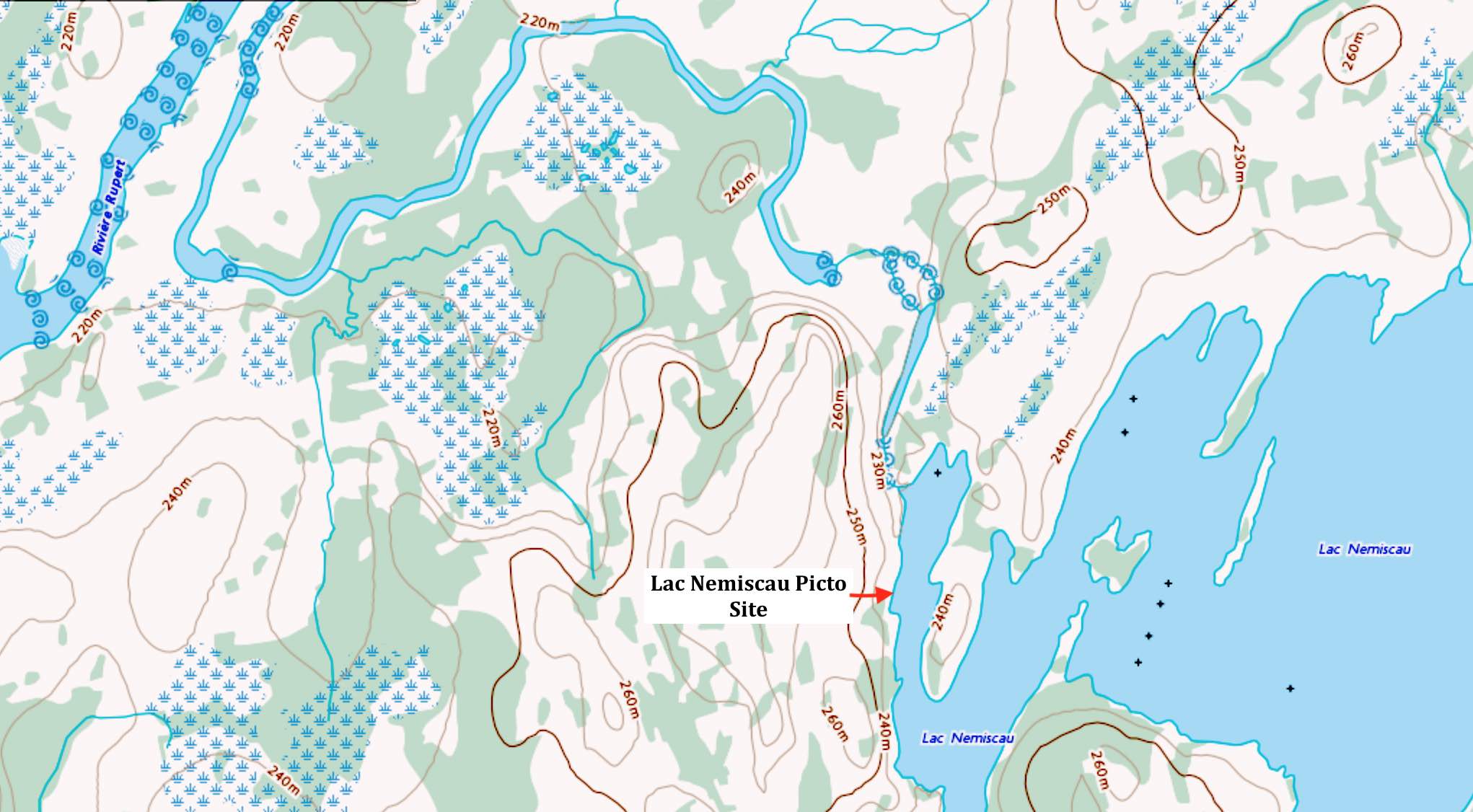
Lac Nemiskau –
(also spelled Nemiscau on some maps) Eastern James Bay area – a part of the Rupert River system; confirmed in the mid-1990s; #2 site in Quebec in terms of importance.
The site is located in the NW section of the lake. Some 15 different panels or faces have been recorded. See Dewdney’s notes on his failed attempt in 1967 to find information about or locate this site.

See here for a close-up of the site location.
The most comprehensive discussion – Pascale Vaillancourt’s 2003 Université Laval doctoral thesis on the site – can be accessed here. The appendix (Annexe E) has a good set of pictures. This is also where I found the Dewdney notes (Annexe C)
Vaillancourt also has a report on the site in Erudit –Le site Kaapehpeshapischinikanuuch (EiGf‐2) :Résultats de l’étude d’un site rupestre à tracés digitaux au lac Nemiscau.
Access the pdf file of his paper here.
——————
2. Site DcGt-41, Abitibi
Lac Duparquet – island location not specified – See here for a reference to the site
——————-
3. Site and 4. mixte DaGu-1 and DaGv-16, Abitibi
Lac Buies – exact location here
——————-
5. Site CcGh-18, Témiscamingue
Dumoine River – location not specified
——————-
6. Site CaGh-2, Outaouais
Rocher a l’Oiseau / Oiseau Rock on the Ottawa River across from Chalk River. See also here and a link to info on the 54-min. documentary Great River (2010) by Matt Lemay here. A Wikipedia article in French can be accessed ici.
Another 2011 UQAM M.A. thesis paper by Emily Royer – Le Site Rupestre du Rocher A L’Oiseau: Palimpeste Patrimonial – provides an excellent introduction to the site and Algonquian culture.
——————-
7. Site BlFs-2, Outaouais. Cap Manitou site
Lac Simon (Cap Manitou)
——————-
8. Site CdFg-5, Mauricie
Lac Wapizagonke – in the news here with an image [link dead in 2022]
——————
9. Site DeEh-1, Côte-Nord. the Nisula Site
Lac Cassette (Pepeshapissinikan) – The site is about 15 kilometers northwest of Forestville. Confusion may be caused if you search for a “Lac de la Cassette”; there are two, and one is on the other side of the St. Lawrence River!
See this Google Map here for the locations of the two different lakes.
See here for some pix and the story (n Finnish and English) of how Anne Nisula found the site in 1985 and then waited a decade for its significance to be confirmed.

Panel II – lines and human figures at what Arsenault calls the main panel
Another source of information is the chapter (pp. 344-359) by Daniel Arsenault in The Rock-Art of Eastern North America: Capturing Images and Insight (2004), edited by Carol Diaz-Granados and James R. Duncan. The chapter, entitled “Analyzing and Dating the Nisula Site,” can be read online (except for two pages) at Google Books – see here.

Nisula Site Map and GPS coordinates – click on map to enlarge
This Youtube video also has images o the Nisula site.
From the analysis, it would seem that the pictographs at this site date back about 2000 years and are much older than the rock paintings found at the other sites in Quebec and most of the sites on the Canadian Shield.
——————
Selwyn Dewdney On Pictographs In Quebec 1967:
Here are some Selwyn Dewdney notes written in 1967 about the pictograph sites of Quebec. Having spent about six weeks interviewing locals, he was only able to identify 1 site!
By 1994 Daniel Arsenault had upped the number to 6. In 2009 he was able to identify 20.
Dewdney (1967) notes about Pictograph Sites in Quebec
———————————
Petroglyph Sites:
A. Site DaGt-3, Abitibi; also Site DaGt-10
Lac Opasatica – site mentioned in an Arsenault study referred to here – the fourth study down
B. Site BiEx-19, Estrie – the Brompton Site …
no information at present…
C. Site DbEu-1, Saguenay-Lac Saint-Jean
no information at present…
update – also sites in the Hudson Strait area – JhEv-1
information needed – St. Maurice River (upper watershed) – exact location not specified
You can access an article – Les Peintures Rupestres du Quebec – by Serge Lemaitre here. It is in both French and English and provides good summary information and GPS coordinates on the following five sites –
- Lac Bluies;
- Rocher-a-l’Oiseau;
- Lac Simon;
- Lac Wapizagonke; and t
- he Nisula site at Lac Casette.
———————————
Any contributions from readers to make this list of Quebec pictograph sites more useful and accurate would be much appreciated. Vous pouvez corresponder avec moi en franćais. true_north@mac.com
Like more info about lac dumoine pictograms history
Colin – is that a question or a statement? Yes, I would like more info about pictographs on the Dumoine!
As far as I know, none have been reported. I have paddled down the Coulonge, another of the Three Sisters. I did not find any evidence of Anishinaabe rock paintings in our trip down the river from Lac au Barrage to the Ottawa. The site at Oiseau Rock on the Ottawa is the only pictograph site I know in the Pontiac region.
Hello. I am trying to figure out which pictographs I visited as a child in the 1960s. We traveled around Lake Huron, and partially around Lake Superior. We visited Wawa, which made me think we visited the pictographs at Lake Superior Provincial Park. However, I thought we looked at them from a platform of some kind, a scaffold-type structure. Current photos of LSPP show people walking along the ledges. Any idea where we might have been? Thank you!
Laura, take a look at my post on the Agawa Rock pictographs. From the details you provide, it is most likely the site you visited. However, in the 1960’s it had not yet been developed to the extent that it is now so the look will be somewhat different. These days there is still a platform with a railing above and to the side of the site with an explanatory board so that may be what you remember. You need to go back to have another look! See this post –
https://albinger.me/2014/08/02/the-anishinaabe-rock-paintings-of-agawa-rock-a-quick-guide/