
 A warm and sunny Monday weather forecast – a perfect day for a longer bike ride. Having explored and revisited the various ride options in my immediate neighbourhood, I have started using the Go Train network to venture a little further afield for some new pavement. This Monday, I added a train ride to Guelph to the list of recent hassle-free trips with my bike on the Go Train to Barrie, Oshawa, St. Catharines, and Burlington.

Go Train – Train routes north, south, west, and east
On weekdays, there is one morning train that leaves Toronto’s Union Station. Its scheduled arrival at Guelph’s downtown Central Station is 11:05. My senior Presto fare for the ride was $8.10.

Union Station to Guelph – a.m. weekday departure
Each car has a designated bike spot at each end. There were a few passengers in the car I was in; I did not see any other cyclists.

designated bike area on the Go Train – one at each end of the car

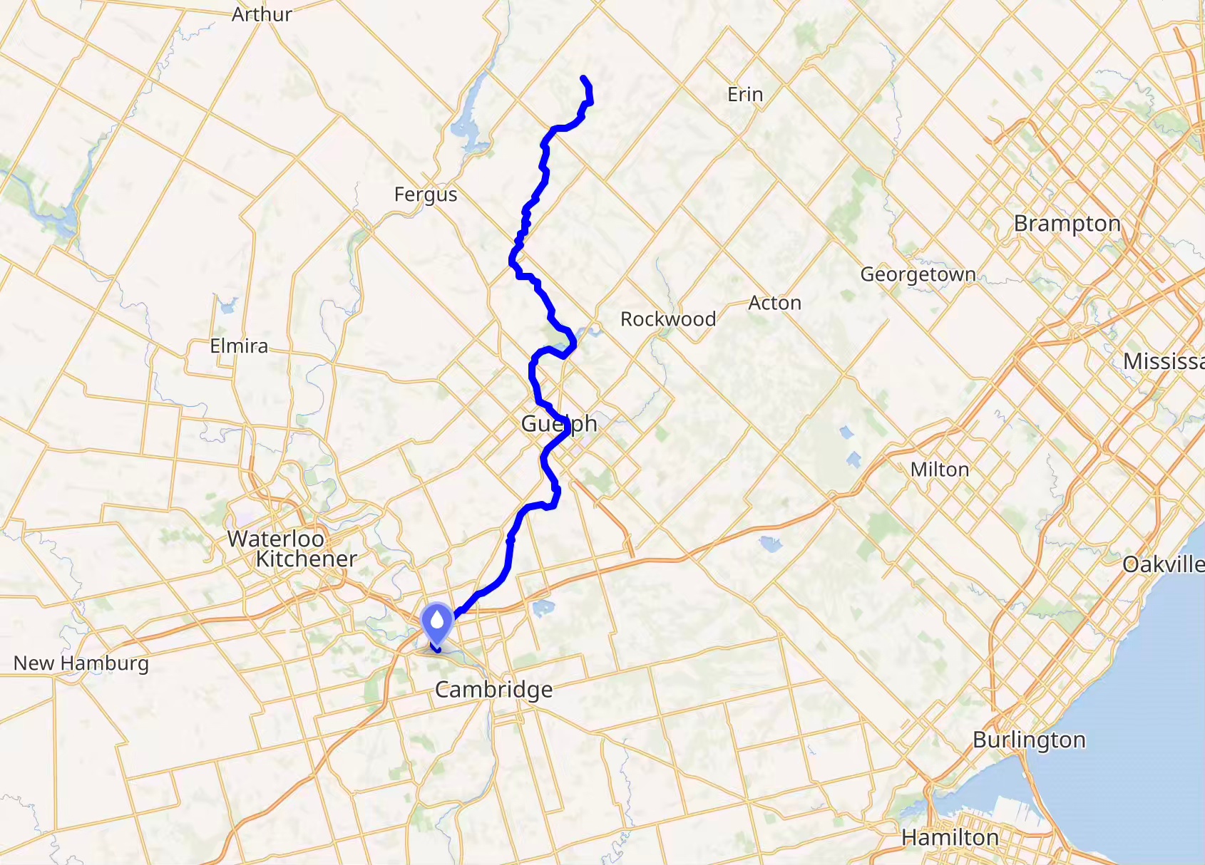
The Ride With GPS map below shows the route back to Toronto’s Riverdale neighbourhood. It is all paved except for a couple of kilometres of gravel along the Eramosa River path at the start. Lots of secondary county roads –
-
- SE on Victoria Road South to
- NE on Wellington Road 34/ 20 Sideroad to
- Fifth Line Nassagaweya to
- 15th Line Sideroad to
- Fourth Line to
- Sixth Sideroad to
- Sixth Sideroad 401 underpass
- The Glen Erin bike path
- Mississauga Road
All of the above took me to Lakeshore at Port Credit. From there, it is a flat ride along Lakeshore Blvd or the Waterfront Trail all the way to Cherry Street and the Bayview Extension Path to Riverdale. Click on the map image to access an interactive view!
Leaving Guelph Central Station, I soon found myself on the only unpaved section of the route: a two-kilometre fine-gravel path along the Eramosa River to Victoria Road.

Guelph Central Station to Victoria Road via the Eramosa River Park Gravel Path

The Eramosa River in downtown Guelph, not far from where it merges with the Speed River
[I had never heard of the two rivers – the Eramosa and the Speed – which frame downtown Guelph! The Eramosa empties into the Speed, which, in turn, merges with the Grand River in Cambridge.]

The Eramosa River gravel path
Once on Victoria Road S., it was 10 kilometres SE to a left-hand turn onto Wellington County Road 35. There was a bit of traffic at the start, but it soon died down. The one-meter-wide bike lane also made it stress-free, as did my first use of my Garmin Varia 515 tail light/radar device. When paired with my iPhone, it gives an audible warning of approaching vehicles from up to 140 metres away and follows that up with an all-clear signal when the vehicles have passed. The device also provides a visual red, yellow, or green warning on a Garmin Edge or the Ride With GPS app I was using.

from Guelph to the 401 via county roads
No bike lane once on Wellington Country Road 35, but there was minimal traffic and paved shoulders. The pavement was in decent shape – no rattling-inducing cracks running across the road every 15 meters!


Wellington County Road 35

County Road north of the 401
While there were no long climbs on the route, the section above the 401 has some rolling hills that got my heart rate into the high 130s or had me ramping up the assist level on my e-bike from Level 1 (Eco) to Level 2 (Tour).

Fifty kilometres and a couple of hours from the start, it was time to deal with the first of the major highway crossings. I avoided the hectic Trafalgar Road crossing with all the on- and off-ramps and crossed the 401 via the Sixth Line overpass. Hassle-free!

401 overpass on Sixth Line
From there, the plan was to cycle all the way down Sixth Line to Lower Baseline Road and then deal with the 407 crossing. However, construction at the corner of Sixth Line and Derry meant I had to take a detour east along Derry Road and then down Trafalgar, the busiest stretch of road I had been on so far into the trip..

a rough stretch of Derry Rd. and an empty field ready for a shopping mall or new subdivision
Somewhere down Sixth Line Road, I stopped for a short break, making use of the shade provided by a tall tree on the edge of someone’s property. A hummus-filled pita, some dates, and the rest of my water … and then it was time to continue.

I’ve come to appreciate kickstands! I parked my bike while I took a short break under the shade of a tree on Sixth Line.
Once back on Lower Baseline Road, an overpass over the 407 and a right-hand turn at Ridgeway Drive, I was on my way to yet another major roadway crossing, that over the 403! Like the two previous ones (over the 401 and the 407), this one was drama-free!

407 and 403 cycle-friendly crossings
A left-hand turn onto Unity Drive took me right to the start of the Glenn Erin Trail at Km 66. A restful 4 km later, I was on Mississauga Road and a mostly downhill roll to Lakeshore Blvd. in Port Credit.

Glenn Erin Trail from Winston Churchill Blvd to Mississauga Road – 4 km
The 32-km ride from Port Credit to the Don River and Riverdale is one I have done a hundred times over the years. Sometimes I take the Waterfront Trail; it avoids Lakeshore Blvd as much as possible for quiet side streets. This time, I took the express route on Lakeshore itself. I also turned off the Varia Radar device to end the constant oncoming vehicle(s) alert warnings!
At Lakeshore and Marine Parade, I headed for the Humber Bridge, and the rest of the ride was on the Waterfront Trail, slowing a little due to the number of joggers and strollers.

The Waterfront Trail near Bathurst – back in the city!
I left Guelph around 11:15 and got home at 4:15, happy to have put in some kilometres on a sunny afternoon on a route through some terrain I had not cycled before. When I checked my workout – i.e. heart rate – data later, I saw the following:

After a winter of indoor cycling on my bike trainer, it felt good to get outdoors and feel the wind and the occasional bumps on the road! And while a Sunday morning would be a better time to avoid traffic, for a weekday, it was not an issue, certainly less of one than what I experienced last month on the secondary roads of Taiwan.
The Go Train network provides access to some great bicycling routes in southern Ontario. The fact that you just wheel your bike on and off the train – no dismantling the bike and putting it in a box – makes it so easy. One of these years, VIA trains on the Toronto-Montreal route will finally allow cyclists the same hassle-free access to eastern Ontario and southern Quebec!