
Table Of Contents:
- Cliff Lake on the Pikitigushi R. system
- The Kopka River’s Seven Sisters section
- The Albany R. Falls – Upper Eskakwa to Snake
- The Misehkow River
- The Palisade River
- The Beckwith Cabins on Best Island
- More Spots Worthy of Consideration
- A Spot You’d Definitely Include
—————————
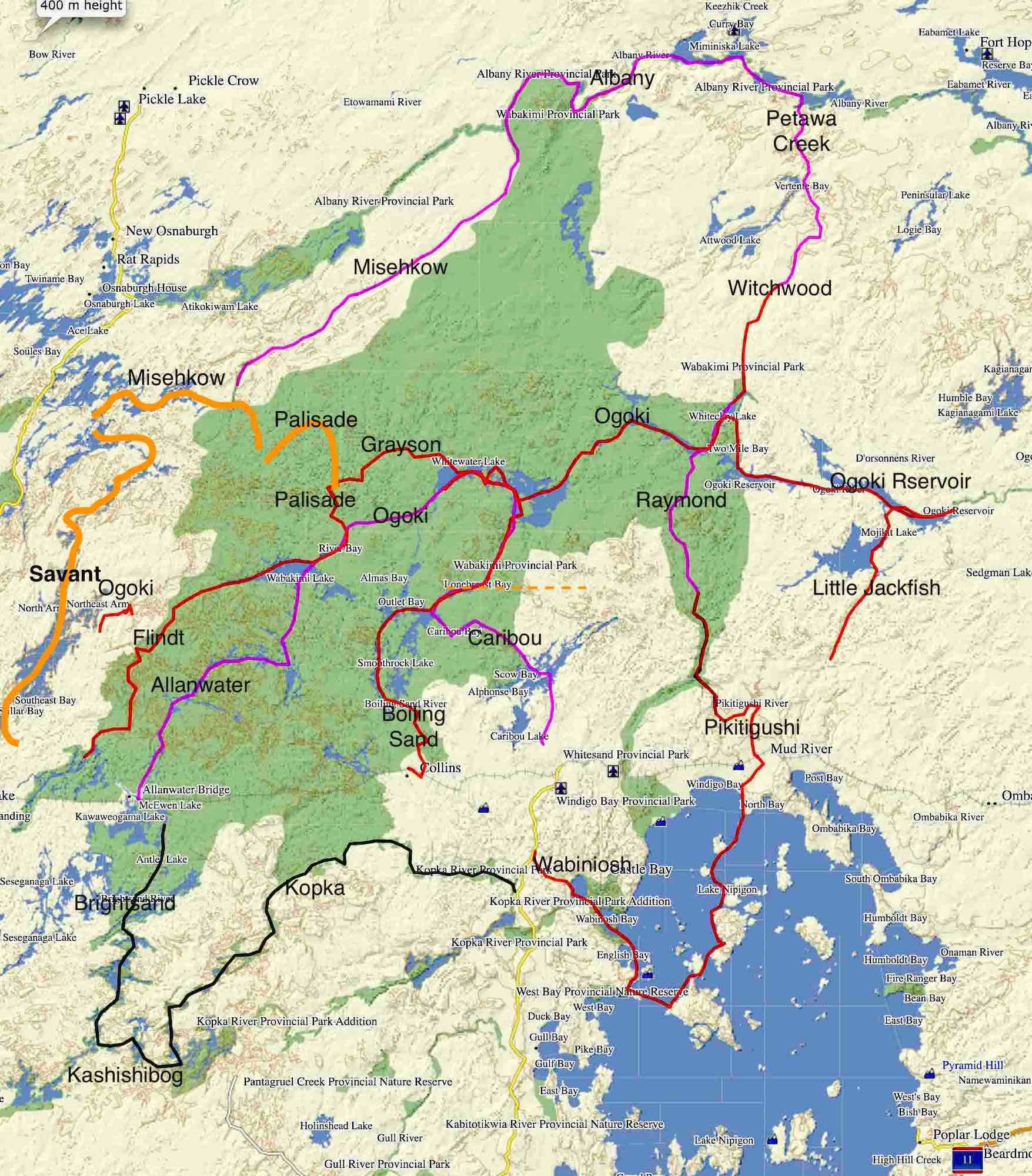
The Wabakimi Canoe Area – Overview with Maps
The Wabakimi Canoe Area – with Wabakimi Provincial Park’s 8,920 square kilometers (3,440 sq. mi.) as its core – is one of Ontario’s more remote and vast paddling destinations. The network of lakes and rivers scratched by retreating glaciers some ten thousand years ago have made this section of the Canadian Shield a paddler’s paradise.

See here to access an interactive Google Maps view of the above for more detail.
Wabakimi Canoe Area’s approximate boundaries are:
- the Albany River to the north,
- Highway 599 to the west, and
- the Kopka River and Lake Nipigon to the south and
- the Little Jackfish River to the east.
The Ogoki River, the longest river within Wabakimi Provincial Park’s boundaries, runs east from its headwaters in Endogoki Lake just outside the park’s boundary near Savant Lake. Wider sections of the Ogoki include Wabakimi Lake, Whitewater Lake, and Whiteclay Lake. The Ogoki Reservoir, meant to divert most (i.e.95%+) of this flow from the James Bay watershed to Lake Nipigon via the Little Jackfish River, was created in the early 1940s with the construction of the Waboose Dam and the height-of-land Summit Dam.

At approximately 27,000 sq. km. (10,400 sq. miles), the Wabakimi Canoe Area is larger than ten U.S. states or five times the province of Prince Edward Island. And the fantastic thing is that this remote section of north-western Ontario sees very few visitors. While some fly-in fishing outposts see some action, the seven hundred or so canoe tripping parties each year have Wabakimi mostly to themselves.
The reward for making the 250-kilometer trip up the highway from Thunder Bay to Armstrong Station is a memorable trip on any one of the many possible combinations of waterways through this slice of the Boreal Forest, limited only by time and ambition and perhaps the willingness to splurge on a bush plane insertion or pick-up.
—————————
Getting Hooked On Wabakimi:
 In early 2010, my bro Max and I hadn’t even considered Wabakimi. Actually, we had never even heard of it! And if we had, the distance from our southern Ontario homes would have made us think hard about driving that far. Then we found Kevin Callan’s book A Paddler’s Guide to Quetico and Beyond; it has a chapter that focuses on the Beckwith Cabins on Best Island in Whitewater Lake. It provided us with the initial motivation to make the 1800-kilometer drive.

Finding the Friends of Wabakimi (formerly Wabakimi Project) website led us to Phil Cotton and Barry Simon and their as-yet-unpublished material for Volume One of the five map sets that this Wabakimi advocacy group has published over the past decade. Now we had what we needed to know about our chosen canoe route. Ken Kokanie’s downloadable map set also helped provide more details on portages and campsites, making our first Wabakimi trip a reality.
Since that first trip, we have been back a half-dozen times. The map below shows the rivers we’ve paddled.
The other day while reminiscing about our various trips – over one hundred paddling days in some of what Wabakimi has to offer – we mulled over a list of our half-dozen favourites, those memorable places with a definite “wow” factor. As subjective as any such list will be, we figure that our attempt to nail The Six has to contain at least a highlight or two that would make the cut no matter who was making it!
—————————
Our Wabakimi Top Six:
- Cliff Lake on the Pikitigushi R. system
- The Kopka River’s Seven Sisters section
- The Albany R. Falls – Upper Eskakwa to Snake
- The Misehkow River
- The Palisade River
- The Beckwith Cabins on Best Island
- More Spots Worthy of Consideration
—————————————————–
1. Cliff Lake on the Pikitigushi River System:

a short stretch of Cliff Lake’s vertical rock face – that’s Max on the cliff edge!
Despite having visited Wabakimi the previous two summers, we had not even heard of Cliff Lake and had no idea what we would find. It took a trip report by Chuck Ryan to make us aware of the lake as one of the great pictograph lakes of the Canadian Shield. While the fifty feet plus in height rock faces that line some stretches of the lake are awesome in themselves, the presence of two or three-hundred-year-old Anishinaabe rock paintings elevates the lake to an even higher level.

the Cliff Lake Pictograph sites with Selwyn Dewdney’s numbering system
The east-facing orientation of these pictographs provides an interesting counterpoint to those on the west-facing Mazinaw Cliffs found on the other side of Ontario in the much more easily accessible Bon Echo Provincial Park.

Cliff Lake – Dewdney’s site #219
We will definitely get back to Cliff Lake one summer soon – and this time, we’ll spend more than a day there to experience the pictographs with hopefully both a setting and rising sun!
For more info on Cliff Lake, see
- The Pictographs of Wabakimi’s Cliff Lake – Selwyn Dewdney Takes Us On A Tour!
- The Pictographs of Wabakimi’s Cliff Lake – Part II.

rock face at the south end of the lake across from the first of the portages to Bad Medicine Lake
Update: In September 2018, we returned for a second look! Check out –
Down The Pikitigushi From Cliff Lake To Lake Nipigon: Logistics, Maps and Day 1 – Cliff Lake
_____________________________
2. The Kopka River – The “Seven Sisters” Section
The Kopka is one of the favourite rivers of Cliff Jacobson, the U.S. version of Ontario’s #1 canoe advocate, Kevin Callan. References to the Kopka River pop up in a couple of his books that I have read. Like Cliff Lake, it wasn’t a destination I was at all familiar with before I started researching. Max and I ended up with a twelve-day canoe trip from Allan Water Bridge to Hwy 529 and a shuttle back to Armstrong Station. It took us up the Brightsand and Kashishibog Rivers and down the Kopka River for the last five days from its headwaters in Redsand Lake.

While the entire trip was memorable, the most dramatic was the section of the Kopka from the south end of Lake Kenakskaniss to the bottom of the last dramatic set of rapids. This stretch makes up the Seven Sisters section of the river. In the barely two-kilometer distance between these two points, there are seven drops in elevation, adding up to an awe-inspiring 215 feet (65 meters).

Portages on the Seven Sisters section of the Kopka River

looking up to the beginning of the first of three sets of Kopka River falls
We were so taken by this stretch of the river that we are planning another trip that will combine it with a return visit to Cliff Lake – the ultimate double-header and one we can do in ten days or less. It would start with a plane ride from Mattice Lake to Cliff Lake and then a three-day paddle down the Pikitigushi River to the Mud River VIA train stop. A train ride to the west of Collins, and we’d access the Kopka via the Aldridge Lake route. The return visit will include more time spent just being there instead of paddling through.
Update 2018: Instead of connecting the two by train, we paddled down Lake Nipigon and up the mouth of the Wabinosh River to Wabinosh Lake, where the Kopka ends its run.
Canoeing Lake Nipigon From Windigo Bay To Echo Rock

Kopka River – view between first and second falls in the Seven Sisters section
For more info on the Kopka River system, see this post –
_____________________________
3. The Albany From Upper Eskakwa to Snake Falls
You can’t go wrong with waterfalls and sets of powerful rapids on any Top Six list; they demand respect and elicit awe from those paddling by. While we missed the challenging rapids just upriver from where the Misehkow empties into the Albany, we did get to experience four sets of Albany waterfalls over two days as we paddled down towards Petawanga Lake.

Well-trodden portage trails around all of them made for easy carries; we would dump our gear at the end of the trail and then walk back upriver with our camera gear, hoping to capture a little of the magic. Upper Eskakwa, Eskakwa, Snake, and Miminiska Falls too – what a buzz to stand there and take it all in!

The Albany River (892 kilometers from its headwaters in Cat Lake to James Bay) shares the “longest river in Ontario” status with the Severn River. And while it is no longer the river it once was, having been neutered by some water diversion schemes, it is still an impressive river. We were glad our canoe trip included at least a few days on this historic waterway of the fur trade era.
For More Info on The Albany: See Paddling The Albany River (From the Mouth of the Misehkow to Petawanga Lake)
_____________________________
4. The Misehkow River
We won’t soon forget the Misehkow, a short, little-travelled river system that flows about one hundred kilometers from its headwaters east and north to merge with the Albany River. The only signs of human activity along the river are an abandoned outpost on Rockcliff Lake where we landed and a mining camp just below the river’s one major waterfall, Iron Falls. What we did see during the three days we spent on the river was a half-dozen moose – more moose than on any stretch of river before.

Morning mist on the Misehkow at Day 3’s “Mooseview” Camp

moose and calf on the Misehkow

at OM on the Misehkow – Day 4 campsite and meditation center!
For more info on the Misehkow, see Canoeing Wabakimi’s Misehkow River.
_____________________________
5. The Palisade River
The Palisade is another short Wabakimi river that empties into Kenoji Lake after winding its way south and east from its headwaters near Burntrock Lake. It has some beautiful narrower stretches that add intimacy to paddling through Canadian Shield country.
We did the scenic stretch from Kenoji up to the turn-off for Scrag Lake. We had actually planned to go all the way up to Burntrock Lake. Unfortunately, it was the summer of 2011, and NW Ontario was ablaze with a record-setting number of massive fires. Thunder Bay 50 had its start right near Burntrock Lake, so our route plan changed.

smoke on the Palisade – the Thunder Bay 50 fire makes its presence known

Update Jan. 2021 – our planned trip down the Ogoki river this summer from its headwaters to the Reservoir will include a side trip up the mouth of the Palisade. This time we will check out a reported four pictograph sites we did not know about in 2013! See here for their reported locations.
_____________________________
6. Whitewater Lake – The Ogoki Lodge & The Beckwith Cabins on Best Island
From Wabakimi Lake, the Ogoki River takes you down to Whitewater Lake, passing through Kenoji Lake. Located around the lake are several lodges and outposts that make it seem quite busy, yet on our two trips across the massive lake, we saw no one…no fishermen and no paddlers.

When we paddled by the Ogoki Lodge, we stepped on shore to take a look. We were surprised to find an abandoned set of buildings, the most impressive being the main lodge pictured below and four cabins and a two-storey motel-like addition. It was an incredible amount of real estate to be sitting there idle, and we wondered what the story was.
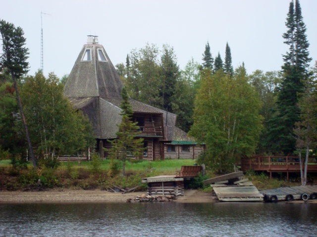
Ogoki Lodge – built in the 1970s and now all but abandoned
One story we later heard was that the tipi-inspired building at Ogoki Lodge was designed by an eccentric American hermit named Wendell Beckwith. He lived on nearby Best Island until he died in 1980. Since it was just a short paddle to Best Island, we checked out what he called “the center of the universe,” feeling a little like pilgrims as we walked around the site and peeked into the three cabins he had constructed.

one of the three Beckwith cabins on Best Island
As impressed as we were with Beckwith’s work, we left with a more depressing thought. It was clear that if something is not done soon, time and nature will combine to bring down the Cabins. The largest of them has a massive hole in the roof open to the elements; the blue tarp seen in the image above was someone’s attempt about a decade ago to deal with the problem. It has been five summers since we were there, and when our thoughts turn to the fate of the Beckwith Cabins, we meditate on the one certainty that nothing in this world can escape.
In 2021 we returned to Best island. Below is what the main cabin looked like. It is the same building Max is standing in front of in the image above.

exterior view of the Main Cabin on Best island – view from the other side
Very little is left of that blue tarp that had been put over the roof in 2007!

a view of the front of Beckwith’s Main Cabin from behind
If only the Cabins could serve as a hook of a different kind to lure visitors to Wabakimi Park. This is where the voice of reason chimes in with a harsh – “Yes, spend a million dollars to preserve and maintain the cabins so that all of fifty or sixty paddlers or fishermen a year can see them!”

For more info on Ogoki Lodge and the Beckwith Cabins, see
The Ogoki Lodge & The Beckwith Cabins: “All Things Must Pass”.
This post from 2021 brings the state of the three cabins up to date.
A Two-Day Paddle Across Wabakimi’s Whitewater Lake
_____________________________
Other Spots That Should Be On The List!
7. Brennan Falls/Granite Falls on the Allan Water River
I know – more waterfalls! The two on the Allanwater River system are especially welcome after spending a day paddling the length of Brennan Lake.

8. Our favourite Wabakimi campsite – a spot on the Kopka
Had it been a rainy day – or had the water level been higher or lower – it may well have been all different. On another day, we may have kept going in search of a campsite further downriver. Instead, we stopped at 2:00 to enjoy one of those perfect afternoons which became a perfect evening. Looking around, we agreed that we were lucky to be smack dab in the middle of one big WOW.

9. Echo Rock … on the southern edge of Wabakimi
A day’s paddle from the mouth of the Kopka River and Wabinosh Lake along the shore of Lake Nipigon is a majestic rock face we have paddled by on the southern edge of Wabakimi country. Even though the rain and wind meant less-than-ideal visits when we first paddled alongside it one afternoon and then again the next morning, we will not forget the power and majesty that this spot exudes. It reminded us of another rock face at the other end of the Anishinaabe world, the one at Bon Echo in eastern Ontario called Mazinaw Rock.

approaching Echo Rock from the east in the rain
_____________________________
A Spot Not Mentioned That You’d Definitely Include:
If you’ve been to Wabakimi, let us know if we hit some of your high points and what spot we missed that really should be mentioned. Send us a jpg image and a comment to go along with it, and we’ll post it right here!
You’ll be giving us ideas on a potential route for our next Wabakimi canoe trip!
_____________________________
Here is the complete collection of Wabakimi-related posts we have uploaded since our first visit in 2010:
The Greater Wabakimi Area:
————-
1. Down Wabakimi’s Allanwater R. To Whitewater L.
On our first visit to Wabakimi, we took the train from Armstrong to Allanwater Bridge and then paddled the route you see on the map below over a ten-day period. Our vehicle was waiting for us at the south end of Little Caribou Lake. After this trip, we were hooked on Wabakimi!

Introduction, Logistics, and Maps
————-
2. Down the Flindt River to Collins Via the Ogoki, the Palisade, the Grayson, and the Boiling Sand Rivers
Thanks to our first trip, we returned the next summer (2011). This time we had fifteen days. Starting at the CN tracks at Flindt Landing on the park’s southwest side, we paddled the route you see in red on the map below.

Introduction, Logistics, and Maps
Days 1 and 2 – Down The Flindt River From the CN Tracks
Days 3 and 4 – The Flindt and Ogoki Rivers
Days 5 and 6 – The Ogoki, the Palisade, and the Grayson Rivers
Days 7 and 8 – The Grayson River and Whitewater Lake
The Ogoki Lodge and The Beckwith Cabins: “All Things Must Pass”
Days 9 and 10 – McKinley Bay To Smoothrock Lake
Days 11 to 15 – From Smoothrock Lake To Collins Via the Boiling Sand River
————-
3. From Allanwater Bridge to the Kopka R. via the Brightsand and Kashishibog Rivers
For the third summer in a row, we drove back up to Wabakimi, an 1800-km. trip from southern Ontario. This time instead of heading north from the CN tracks, we headed south and, after paddling up the Brightsand and Kashishibog Rivers, entered the headwaters of the Kopka River. We followed it all the way down to Bukemiga Lake and the access road to Hwy. 527, where Clem Quenville was waiting to shuttle us up to our vehicle in Armstrong.

Canoe Trip Plans: From Allanwater Bridge to the Kopka
————-
4. Down The Misehkow and Albany Rivers…

bush plane insertion and 220 miles of paddling and portaging
and then back south via Petawa Creek, Hurst Lake, the Witchwood River, the Raymond River, and the Pikitigushi River to the side of the road from Armstrong Stn. where a Mattice lake Outfitter shuttle was waiting. We were back for the fourth summer in a row!
At 17 solid days, this was one of our longer trips, and it remains my brother’s favourite. It really was an epic made more interesting because of the gaps in the information we had on what was coming up. Our posts should help clarify more of what you’ll paddle into.
Overview: Paddling The Perimeter of Wabikimi Provincial Park
Wabakimi Canoe Trip Plans: Misehkow, Albany, Witchwood, Raymond, Pikitigushi Rivers
Canoeing Wabakimi’s Misehkow River
Paddling the Albany River (From the Mouth of the Misehkow to Petawanga Lake)
Up Wabakimi’s Petawa Creek Without A Paddle
Paddling From Auger Lake to Felsia Lake (The Mouth of the Witchwood River)
A Two_Day Paddle Up Wabakimi’s Witchwood River System
Up Wabakimi’s Raymond River to Cliff Lake
Down Wabakimi’s Pikitigushi River From Cliff Lake
————-
5A. The Pikitigushi R. From Cliff Lake To Windigo Bay
After an absence of a few summers when we did trips down the Bloodvein, the Coulonge, Temagami, and the French River area, we were back for an early September trip. We flew into Cliff Lake, one of our favourite Wabakimi spots, and then paddled the route you see sketched on the map below.
The first part of the adventure ended with a descent of the Pikitigushi to Windigo Bay. We could find no record or information from anyone having done it. It turned out to be a very enjoyable two-day paddle!

From Cliff Lake To Lake Nipigon: Logistics. Maps, and Day 1 – Cliff Lake
From Cliff Lake To Lake Nipigon: Days 2 & 3 – From Cliff Lake to The Bear Camp
From Cliff Lake To Lake Nipigon: Days 3, 4, &5 – From The Bear Camp To Windigo Bay
The second part of the trip (5B) had the potential for some real drama since we paddled out into Lake Nipigon. Making use of a string of islands that stretches from Windigo Bay to Gull Bay, we spent three days on the lake before hitting the mainland at Echo Rock near Jackfish Island. We returned to Hwy 599 via the Wabinosh River. On the way, we looked for a reported WWII prisoner-of-war camp a local had told us about before the start of the trip.
——-
5B. Windigo Bay To Echo Rock and Up To Waweig Lake
The NW Corner of Lake Nipigon: Windigo Bay To Echo Rock to Waweig Lake
Canoeing From Lake Nipigon’s Echo Rock To Waweig Lake
————-
6. Wabakimi’s Upper Ogoki River: From Top To Bottom (Almost!)
In July of 2021, we were dropped off by an MLO Beaver in Endogoki Lake, the headwaters lake of the Ogoki River. Our plan was to paddle all the way down to the Waboose Dam at the east end of the Ogoki Reservoir before following the redirected upper Ogoki’s water down the Little Jackfish. As the first couple of posts below reveal, we experienced some “challenges” during the first few days! They were followed by a week and a half of drama-free paddling down the Ogoki to the Waboose Dam and on to the Little Jackfish.
We now have some new Wabakimi highlights to add to our post on A Paddler’s List of Wabakimi’s Top Six Scenic Spots!

The Ogoki River From Top To Bottom
Bushwhacking The Ogoki Headwaters: Endogoki Lake Days 1 & 2
Bushwhacking The Ogoki Headwaters: Days 3, 4, and 5
A Two-Day Paddle Across the Ogoki’s Whitewater Lake
Down The Ogoki – From Above Ogoki Falls To Whiteclay Lake’s NE Arm
Down The Ogoki – From Whiteclay Lake (NE Arm) To The Ogoki Reservoir (Two Mile Bay)
Canoeing The Ogoki Reservoir: From Eight Flume Falls to “Moose Crossing”
Canoeing The Ogoki Reservoir – From “Moose Crossing” To The Waboose Dam
Paddling The Ogoki Reservoir From Waboose Dam To South Summit Dam
Paddling Down The Little Jackfish River From The Summit Dam To Zigzag Lake
————-
September 2023
7A. DownThe Savant River To East Pashkokogan Lake
- Accessing Wabakimi Canoe Country
- A Journey Worth Making
- Our West Side of Wabakimi Route Through The Caribou Forest
- Northern Canada Wildfires And Canoe Trip Planning
- Getting To The Put-In From Toronto
- VIA Rail – Washago To Savant Lake VIA Stop
- Our Shuttle Provider: Jonah Belmore
Maps and Information (Rapids, Portages, Campsites, etc.)
- Natural Resources Canada 1:50,000 Topos
- David Crawshay’s Topo Canada iOS App
- ATLOGIS Canada Topo Maps for Android OS
- Toporama Canada Online Map
- Wabakimi Project Maps – Info on Rapids and Portages
- Paddle Planner
- Our Roue GPX and Kml Files – from Max’s Garmin Etrex 20
Day-By-Day Details
- Day 1: Jutten Lake
- Day 2: Halfway Down Savant Lake
- Day 3: Down Savant Lake’s North Arm
- Day 4: Into Jabez Lake
- Day 5: Jabez to Savant Falls
- Day 6: Savant Falls To Velos Lake
- Day 7: Velos Lake to McCrae Lake
- Day 8: McCrae Lake to East Pashkokogan
——-
7B. From East Pashkokogan Lake To Kenoji Lake Via The Misehkow & Palisade Rivers
- Route Overview Map and GPX file
- Day 8: From East Pashkokogan Lake To Greenbush Lake
- Day 9: From Greenbush Lake To Metig Lake
- Getting a Wabakimi Park Backcountry Camping Permit
- Day 10: From Metig Lake To Muskiga Lake
- Day 11: From Muskiga Lake To Burntrock Lake
- The Headwaters of the Palisade River system
- History of Wildfires in the Burntrock to Kenoji Area
- Day 12: From Burntrock Lake Down The Palisade River
- Day 13: Down The Palisade Almost To Kenoji
- How The Palisade River Got Its Name
- Looking For the Palisade Pictographs
- Day 14: Bush Plane Pick-Up On Kenoji Lake
- Day 15: A Visit To Armstrong Station’s NORAD Radar Base/The Train Ride Back To Southern Ontario


Wow Wabakimi looks amazing. I’ve never been that far north in Ontario, well not past Thunderbay or Timmins that is. Planning a trip up with the girlfriend to Sleeping Giant PP, Neys PP, Pukaskwa NP and Lake Superior PP. Any tips for a first timer to Norther Ontario parks?
Boris, until a few years ago my canoe partner – and brother – and I hadn’t really ventured west of Wawa and the Soo. What we found when we did was an epic country with incredible rivers to paddle.
The drive to Thunder Bay is a long one but you get to experience – especially in the section from Marathon to Nipigon – one of the most dramatic stretches of highway in Canada. Last summer we paddled the Steel River, which is located in the country just northwest of Marathon.
A ride up there would be a great introduction to a part of Canada that is sure to draw you back time and again. The parks themselves are in great locations and should provide your camera with a good workout!
That’s what I’m hoping. Sadly I’m a very novice canoe-er and this trip is with the girlfriend. so sadly long canoe sections are limiting. But I’m looking at some rental places so I can hit lake superior on different sections.
Hiking – either day hikes or a multi-day at Pukaskwa – might be the way to go. Less complicated than the canoeing option – no need for rentals – and there are some beautiful boreal forest trails to walk. This website should give you lots of ideas!
http://www.voyageurtrail.ca/trailscasqueisles.html

Definitely check out the pictographs at Agawa Rock in Lake Superior N.P. And make sure to stand underneath the giant goose at the entrance of Wawa.
Happy trails!
I got a campsite right on the water at Agawa. Looking forward to the experience. Sadly multi-day excursions won’t happen this time as most will be day hikes. But I do how to get one out and back overnight at Pukaskwa
Just found your site (love it), while researching my summer canoe trip this year – to Wabakimi. Do you have any recommended resources, maps, reading, etc?
You might want to check out any of our Wabakimi trip reports – there are four of them! They all have what you’re looking for. See this blog’s Canoe Tripping folder –
An obvious first place to go is The Wabakimi Project website for maps and access info. To get started click here
Feel free to email me if you have some specific questions in mind; my bro and I may have the answer!
Wabakimi is an undiscovered paddlers’ paradise that will have you hooked after your first visit.
I’m planning a Wabakimi trip again this summer and plan to return on the VIA train from Collins to Toronto. This time I’ll try Whitewater Lake and the centre of the universe.
I will finish in Union Station but don’t know to get my canoe and gear out of Union Station. I’ve gone before from/to Washago so there were no problems, but can’t do it this year. I’ve called VIA but they didn’t know. If you have any suggestions, I sure would appreciate them. Dan
Dan, the two times we went by train the canoe went on in London, taken off at Union and brought to the luggage room, and then loaded again that evening. Because it was two trains it was double the cost! These days that would be $100. X 2!
Are you carrying the canoe and gear to a waiting vehicle? You can walk the canoe from the luggage room at the bottom of the ramp at Union Station to Front Street itself. You may need two people, one to deal with the doors! I guess you would want to walk it to wherever your car is parked nearby.
It might be best to go down yourself and take a look at the layout and the parking situation given all the construction and changes down there! The train arrives around 9 a.m. (if it is actually on time!) so you get to hit the end of rush hour!
Should be some nice photos of a what looks like a homeless person walking around with a canoe on his head! Good luck getting the CN Tower in the shot!
Hi – Which airline did you use from Mattice Lake to Cliff Lake? Thanks!
Paul, Cliff Lake is definitely worth a couple days’ visit. On our visit we paddled into the lake from the north.
If you want to fly in, Mattice Lake Outfitters is the plane service we have used for other drop-ins. You could paddle back to a take-out spot on the logging road on the Pikitigushi River below Pikitigushi Lake.
You could save some money by paddling up to the lake from that logging road put-in on the Pikitigushi River. Mattice Lake Outiftters does shuttles or you could drive your own car and leave it at the Boucher Bear Camp there. It would take a day or a day and a half to get to Cliff lake but would be cheaper!
A local by the name of Clement Quenville may have some other way of getting you there and might be worth contacting. Here is his wife’s email address – june@vianet.ca
Enjoy your time on the lake – awesome vertical rock face, a couple of great campsites and, of course, the pictographs!
Fantastic resource! I’m planning a trip to Wabakimi in the summer of 2021 (so we have some time to plan). We’ll have 4 paddlers coming from the US > Thunder Bay > Armstrong. We’d like to take the train in (or out) and would have 6-7 days of paddling that would be shouldered by travel to/from home. We’d prefer lake hopping and/or class I-II rapids – nothing too exciting. Is there a recommendation or route that immediately comes to mind that I should research? Again, great articles… I’m working my way through them all now. Thanks in advance for your help!
Adam, nice to hear you are finding the trip reports of use.
Wabakimi has certainly gotten our attention over the past ten summers! Next summer we are going back yet again for another two-week -or-so adventure.
The summer of 2021 means you will certainly have enough time to make plans. the biggest thing will probably be geting all four paddlers to agree to one date!
Re: possible trips.
1. In all cases, you will drive up to Armstrong Station, a small community at the end of the road (paved and in excellent shape) from Thunder Bay. It takes about 2 1/2 to 3 hours to drive.
2. You will hop on the westbound VIA train as it comes through Armstrong around 9:17 a.m. Here is the link to the current schedule. The train can be very late since the main reason the rail line exists is to move freight and not people!
Click to access 40-41_Toronto-Winnipeg-Jasper-Vancouver.pdf
Depending on where you are coming from in the US, it might be easier to catch the train as it is coming east towards Wabakimi. Sioux Lookout is a possibility.
3. Your route requirements match my brother and mine. Since we are always on our own – i.e. one canoe – we really don’t take a lot of chances with rapids. Class 1 and class 2 easy is as far as we usually go. The portages are rarely very long.
Given your time frame, of the trips we have done I would probably suggest a short version of the first one we did . Get off at Allan Water bridge, paddle down the Allan Water River to Wabakimi Lake, and then head back to Lower Wabakimi and up the Caribou River to Caribou lake and over to Little Caribou Lake to the gravel road. You can get a shuttle to have your vehicle there when you arrive. It is 6 km. 9about 3.5 miles) from the take out sport to Armstrong Stn and the long ride back to the US. Here is a map set for the trip I am suggesting you consider.
Click to access ken-kokanie-_allanwater_to_little_caribou_pdf.pdf
My trip report on an extended version of Ken Kokanie’s route is described in the trip report below. Note! This trip report is the first one I ever wrote. It is somewhat disorganized. I had no idea what I was doing other than providing a context for the photographs!
Have fun planning your trip.
Next September/October I hopefully will have posted a report on our planned trip from the west side of the park at Savant Lake to the headwaters of the Ogoki River (Endogoki Lake) down the length of the Ogoki River to the east end of Wabakimi Park at Whiteclay lake.
Good luck with your planning.
Feel free to email again if you have more questions.
Also, do note that wabakimi.org is a great source of info and it mostly run by avid canoeists from Wisconsin and Michigan.
Hey there…
I’ve been planning my Kopka river trip for a few weeks now, buy I’ve become intrigued with Savant/Albany/Misehkow..back to Armstrong, a 3-4 week trip. I’m curious: if you had to choose, would it be Kopka or the above mentioned route?
Paul, choices! choices! Both are quite scenic; neither is much-travelled; the northern choice feels wilder and more off the grid and might actually take three weeks or more; the Kopka choice is easier in terms of logistics and is a shorter trip.
The Kopka is definitely not a three-to-four week trip; it is more like a two-week one. For the first five, you go up river systems until Redsand Lake, the Kopka headwaters. I thought you did this one last summer? If you haven’t and are still interested, I can send you the wabakimi maps.com laminated map sheets of the route.
It is a beautiful trip to make and you’ll have it pretty much to yourself. To make it a bit longer you could paddle down into Wabinosh Lake; one easy portage and you’d be right in Lake Nipigon. There is a rough road that comes to the NE side of Wabinosh lake. You might be able to arrange a shuttle that would take you from there back to Armstrong and the VIA train east.
Re: the Savant/Albany/Misehkow..back to Armstrong route…that is a bit more ambitious! You could definitely spend three weeks on this, maybe more, especially if you are doing it solo. After getting off at the Savant Lake VIA stop, you’d need to get a shuttle to either Savant Lake or further up Hwy 599 to Osnaburgh Lake. Some great rapids on the Albany before it gets to the point where the Misehkow comes in. [We have not done the stretch of the Albany. above its confluence with the Misehkow.]
Paddling up the Misehkow will be a bit of work; we paddled down the Misehkow after getting flown to Rockcliff Lake from Mattice Lake near Armstrong.
East of the Misehkow is where a wildfire back in 2012 burned the area around Burntrock Lake. You’d be paddling through there and then down the Palisade River to Kenoji Lake and the Ogoki River system. A number of different ways of getting back to Armstrong from there depending on time.
You could – with a bush plane drop off – retrace our 2013 trip down the Misehkow, the Albany, and then up a few rivers to get back to a shuttle at the logging road that goes to Armstrong. It would definitely take you 21 + days! That was my brother’s all-time favourite canoe trip! [We copied the route from a 2009 trip report on the myccr forum.]
This August we are taking the train to Savant Lake, getting shuttled to the west side of the Lake itself, and then paddling the Ogoki river as far as the east end of Whiteclay Lake where we turn south up the Raymond to the Pikitigushi. We plan to hop on to the VIA train at Mud River 16 days later! We’ll be stringing together pieces of the Ogoki we have done in summers past, as well as paddling some new water. The headwaters of the Ogoki is a small lake called Endogoki; we will bushwhack the 500 meters to the lake from Savant Lake. I still have to find someone who does shuttles in the Savant Lake area.
Let me know if you want those laminated Kopka maps. Have fun making up your mind. The truth is – both need to be done! The one you don’t do this year, you will do some other!
Peter,
I’ve delayed replying because of the number of routes travelling through my head at any given time and because I’m still waiting for the Friends of Wabakimi maps to arrive. Last week, I settled on this route:
– Red Head up the Nemo River, Grayson, Whiteclay, Raymond, Pitigushi, which we were planning to do in 12 days.
That said, I found my brain returning the Misehkow:
– Fitchie, Savant, Savant River, Rockcliff, down MIsehkow and up the Albany and back to Fitchie.
The problem is, it’s not clear to me (because I’m still waiting for the FOW maps to arrive) whether the Fitchie-Savant River-Misehkow loop is a viable 12-day route, though my paddling distances tend to resemble yours. And, if it’s not viable, would removing the Misehkow and would doing a side trip to Palisade, then returning via Velos be viable?
I’ve seen your favourable comments on Misehkow and the Savant River (here and on CCR) and as you’ve pointed out it looks to be more wild than, perhaps, Brennan/Smoothrock.
Would love to hear your thoughts on these questions and reflections. In fact, I’ve outlined the first route as well as the second here: https://www.google.com/maps/d/u/0/viewer?mid=1oD3iK9Ea_gqsmSVm_viXAmEvqA_A3jsj&ll=51.022331822568525%2C-90.27433999454405&z=10
The second (black-lined route) is rougher due to lack of maps, but you’ll get the gist.
Btw, I cannot overstate how helpful your blog and replies have been over the years.
Paul
Paul, so many choices! You will be going back so what you don’t do this time you will do some other summer! My bro and I figure about 25 kilometers a day; 4 kilometers an hour seems to be the average.
You use the pronoun “we’ so I am assuming you have a paddling partner. That should make the portages and kilometers go by faster!
How about getting to the put-in and back? Are you driving up to Armstrong Station or Savant Lake? You Fitchie option sounds like you plan to park your vehicle by the highway and paddle back to it in 12 days. Paddling up that stretch of the Albany doesn’t sound like much fun! If you check out Ken Kokanie’s maps, that stretch has some major rapids and fast water. It would take you four or five days to get to the Misehkow, another four days to go down, and then 70 km up the Albany to Osnaburgh Lake and the mouth of the Savant River. 12 days would not be enough for this loop – maybe three weeks would do.
Note: we’ve never paddled the Savant River or the Lake; I would guess few have and that the portages, if they still exist, will be quite overgrown. We have done the Misehkow and other than the one trip report we drew info from there was not much available on it either. We did enjoy our time on the Misehkow – it was Part 1 of a multi-faceted trip that involved all sorts of different terrain and challenges. It remains my bro’s favourite canoe trip! It took us 17 days with a bush plane insertion at Rockcliff Lake and a shuttle from the Bear Camp on the Pikitigushi.
I took a look at the google page with your two routes roughly outlined on the terrain map. My overall impression is “Whoa – these guys are gonna be busy! I sure hope they post a trip report cuz it’s one I want to read!”
Peter,
I feel so badly inundating your page with my rambling questions. It turns out your comment about Endogoki Lake is the key to our trip (Savant-Wabakimi-Velos loop). My FOW maps are on their way to me and I spoke to Barry Simon about it briefly. He indicated, as you did, to expect bushwhacking and blowdown. If you happen to have any info on the location of the portage and route into Ogoki (while waiting for the maps) I’d love that.
Paul
Paul, one of my obsessions is doing rivers right from their headwaters. The Ogoki has long been a thing with me; I remember thinking about paddling it fifty years ago! Well, given that Endogoki looks to be the headwaters (if you forget the two little lakes that empty into it from the north and south!), I talked my brother into a rough carry into the lake from Savant Lake.
You ask – If you happen to have any info on the location of the portage and route into Ogoki (while waiting for the maps) I’d love that.
We have no idea but, given past experience, we figure we can deal with what we find.
Here is an overview map of the Savant Lake area from the VIA stop north …
There is a possible put-in about 50 kilometers from the VIA stop up Hwy 599. The logging road is hopefully in decent shape!
The conventional portage is the 700-meter one indicated to the north of Endogoki Lake; it is shown on one of the Wabakimi Project maps. I have no idea if it is still in use. We will instead be creating our own portage into Endogoki Lake; it is a 500-meter carry that we hope we can get done in an hour or two. Time will tell!
This is a satellite view of the area where we will carry into Endogoki.
The portage that the Wabakimi Project indicated on their map (but did not clear) is the 700-meter one indicated to the north of the lake; it bypasses Endogoki and the initial two kilometers of the Ogoki. We plan to bushwhack into the lake at one of the narrowest sections. It will be about 500 meters. We are hoping it will be relatively hassle-free!
From there it would just be a straightforward paddle down the Ogoki River all the way to Whiteclay Lake and the mouth of the Raymond River which we would paddle up to the Height of Land and then go down the Pikitigushi River system.
Except for the first 45 kilometers from Endogoki Lake to Tew lake and the stretch from Whitewater Lake to Whiteclay lake, we have paddled most of the upper Ogoki already. The original dream had been to go right up to the Waboose Dam at the east end of the Ogoki Reservoir but was nixed by the reality of paddling a 70-km.stretch of flat water to get to there! I’d also like to do the stretch from the dam down to where the Ogoki meets the Albany!
Keep the info flowing guys. This is great info. With all the downtime we are incurring, canoe planning is a great way to widdle away the days. Our plans are to head up to WCPP for 9 days but are always open to other areas and routes. We’re coming up from Pittsburgh, Pa. We’d love to visit Wabakimi!!
That is quite the ride – all the way from the east coast! Always nice to plant the seeds of the next canoe trip – and WCPP and Wabakimi are certainly choice paddlers’ dreamscapes. We’ve spent the winter planning an 18-day cross-Wabakimi trip on the Ogoki River system but the COVID-19 situation may prevent a mid-August departure. Looks like patience and flexibility are the keys in 2020!
Re: WCPP…the Bloodview is an incredible river to paddle down – very scenic, some nice rapids to run, and easy portages when the water is a bit too gnarly for your comfort zone. Of course, by then you’d be into Manitoba a and yet further away from Pittsburgh!
Good luck with the trip you end up choosing! And what you don’t get to this year you can do the next!