“Everyone must believe in something. I believe I’ll go canoeing.”
quote attributed (probably falsely!) to Henry David Thoreau

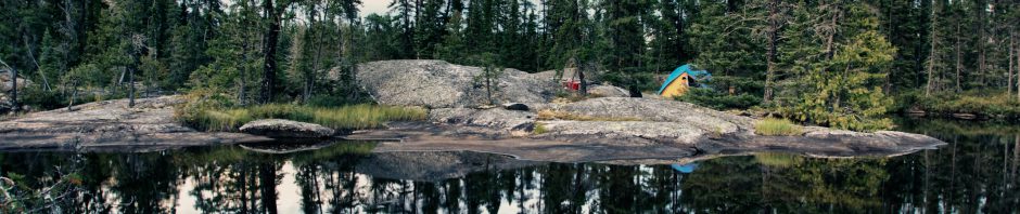
The CN Tower and the Skydome ( its name is currently the Rogers Center) from Lake Ontario
Canoeing the waters of my hometown is okay but summer calls for a bit more adventure! It is late July and my brother Max and I are off for a three-week canoe trip in Northwestern Ontario, in a little slice of the country the voyageurs of old called Le Petit Nord. It is that vast expanse of the Canadian Shield from James Bay all the way to the eastern shores of Lake Winnipeg.
For a while, this past winter it looked like a return to the Missinaibi River (map here) was on order. It is one of North America’s great wilderness rivers, free-running from one end to the other ,,, and in years gone by it is where we developed our canoe tripping skills. We first did the entire river in the early 1980s and have more recently (2003) revisited the upper section for a fourth time.

a disorienting shot! – calm water in the bay below Beaver Falls on the Missinaibi River
I leafed through my copy of Hap Wilson’s volume on the river (Missinaibi: Journey To The Northern Sky: From Lake Superior To James Bay By Canoe) again; we made contact with an outfitter who could pick up our vehicle in Hearst at the beginning of the trip and have it in Cochrane at the end when we got off the Polar Bear Express from either Moosonee or Moose River Crossing.

our Grumman in the Algoma Central baggage car in Hearst at the start of our Missinaibi paddle – we take the train down south towards Wawa for a put-in at Lake Wabatongushi
In the end, I’m not sure exactly why we put the Missinaibi on the back burner for now. Complications with the shuttle arrangements? The urge to have new and seemingly unpronounceable names like Misehkow or Miminiska or Petawanga or Pikitigushi roll off our tongues as if we were born saying them? (See here for the Missinaibi shuttle solution I found too late for this year. There is always 2014! 😊)
Whatever the case – we’re putting the canoe on top of the car one more time this July 27th. for the day-and-a-half drive from southern Ontario to what has become our summer camp – i.e. Wabakimi Provincial Park.
(See the Canoe Tripping folder for our canoe posts, many of which deal with Wabakimi along with new ones in the Temagami and Bloodvein areas).

on the Yukon River in the summer of 1978 – my first great canoe trip! From the left that would be Graeme, Jim, me, Barb, Roy, and Obie. The Grummans were Hudson Bay Company rentals out of Whitehorse. We paddled them to Dawson City, some 500 miles downriver. (Map here)
We’ve managed to add some extra paddling days this time, thanks to my brother’s recent acceptance of that state known as “early retirement” and the indulgence of our wives, who get to watch the trip progress via the GPS coordinates sent from our Spot Connect! While the trip won’t be quite as long as the six weeks we spent paddling from just east of Pickle Lake to James Bay on the Otoskwin/Attawapiskat River systems (click on the blue text for the Google map) way back in 1982, it will be five or six days longer than any of our recent ones.
The weather forecast for the first fifteen days is a mixed bag. While I’d love to see a string of smiling sun icons right across the page, in the end you’ve got to take each day as it comes.

Armstrong Station – 14-Day Weather Forecast – see here for today’s actual weather
Some rain – without thunderstorms and lightning! – will help cool down the boreal forest and make sure that we do not get a repeat of the Summer of the Fires (2011). Our area is showing no fires before our departure. Click here for the latest.
Here is the overview of the route, which will take us into areas of the park and just outside of it that we have not paddled on our three previous visits to Wabakimi.

2013 Wabakimi Canoe Trip Overview – the Google interactive version is HERE – zoom in or out, change to satellite view, and get more detail
In brief, the plan is this – drive up to Mattice Lake Outfitters just south of Armstrong Station for noon and hopefully get dropped off by their float plane at Rockcliff Lake by late afternoon. Weather and wind will determine exactly when we get to go!
The first half of the trip is downriver in an NE direction on the Misehkow River to where it meets the Albany River. Paddling with the Albany current will take us to Petawanga Lake. The approximate distance is 180 kilometres.
The second half of the trip is southbound and mostly upriver. From Petawanga Lake we work our way back to Armstrong Station, paddling up Petawa Creek to Hurst Lake and then up the Witchwood River system to Whiteclay Lake. Then we follow the Raymond River system to the height of land and the beginnings of the Pikitigushi River, which flows southward to Lake Nipigon. After reaching Pikitigushi Lake we travel a bit further downriver to a take-out point where a logging road from Armstrong Station crosses the river. We had initially thought of paddling the Pikitigushi River right to the CN tracks and catching the eastbound VIA there. However, a look at the map (here) reveals a crazy stretch of meandering river! While we will no longer be training it back to Toronto, we may paddle down the river from the pick-up point if we have some extra time at the end – maybe to check the state of the long portage which cuts off some of the worst of the meandering.

Pikitigushi River Take-out Spots – logging road or the CN tracks at the Mud River stop
An afternoon shuttle back to our vehicle at Mattice Lake Outfitters and we will be able to say that we did indeed git ‘er dun!
2013 Wabakimi Tentative Day-By-Day:
We will spend a day and a half to get to Armstrong and Mattice Lake Outfitters – Our drive up from Toronto to Marathon is a 7:00 a.m. start. The next morning we head to Armstrong, arriving around 1 p.m. with a possible flight to Rockcliff Lake early that evening or, if not, the next morning.
Northbound section – total distance 184.5 km
From Distance To
Day 1 S end of Rockcliff Lake 13.5 km campsite at N end of the lake
Day 2 Rockcliff Lake north end 29 km Iron Falls
(Portages – Total of 6 for 1790 m )
Day 3 Iron Falls 26 km camp N of Heather Lake
(Portages – Total of 2 for 100 m )
Day 4 N of Heather Lake 34.5 km junction of Albany River
(Portages – Total of 2 for 400 m )
Day 5 Albany junction camp 35 km Upper Eskakwa Falls
(Portages – Total of 1 for 375 m )
Day 6 Upper Eskakwa Falls 35 km Miminiska Falls campsite
Series of swifts from Upper Eskakwa to Eskakwa Falls; P Eskakwa Falls 125 L
Series of swifts after Eskakwa Falls; P Snake Falls 270 m L ; P860 Miminiska Falls SE of small island
(Portages – Total of 3 for 1255 m )
Day 7 spare day
Day 8 Miminiska Falls camp 11.5 km Petawanga island camp
total portages and distance first half 14 – 3920m
+++++++++++++++++++++++++++++++++++++++++++++++++++++++
Southbound Section 177.5 km.
Day 9 Petawanga Island camp 24 km Outpost Auger Lake
(P Total of 2 for 600 m )
Day 10 Auger Lake outpost 24 km S end of Felsia L/ Witchwood R
(P Total of 3 for 1390 m )
Day 11 Felsia Lake campsite 30 km camp N of logging road
(P Total of 7 for 1445 m )
Day 12 Witchwood R bend 26 km NE Arm of Whiteclay L
(P Total of 2 for 1775 m )
Day 13 NE Whiteclay Lake 22 km Raymond R to Pickett L
(P Total of 1 for 300 m )
Day 14 Pickett Lake 10 km campsite on Butland L
(P Total of 5 for 2770 m )
Day 15 Butland L camp 16 km Cliff Lake – east side
(P Total of 1 for 1440 m )
Day 16 Pictograph Appreciation Day at Cliff Lake
Day 17 Cliff Lake 16 km Wash L. or Derraugh L
(P Total of 5 for 1150 m )
Day 18 Derraugh L camp 12 km logging road – Pikitigushi R.
total portages and distance – second half of trip = 28 for 12,370 m
Trip total – 42 portages and 16,290 meters (or so!)
See Paddling the Perimeter of Wabakimi Provincial Park for the complete list of posts
Paddling the Perimeter of Wabakimi Provincial Park – Overview Map and Links To Detailed Posts
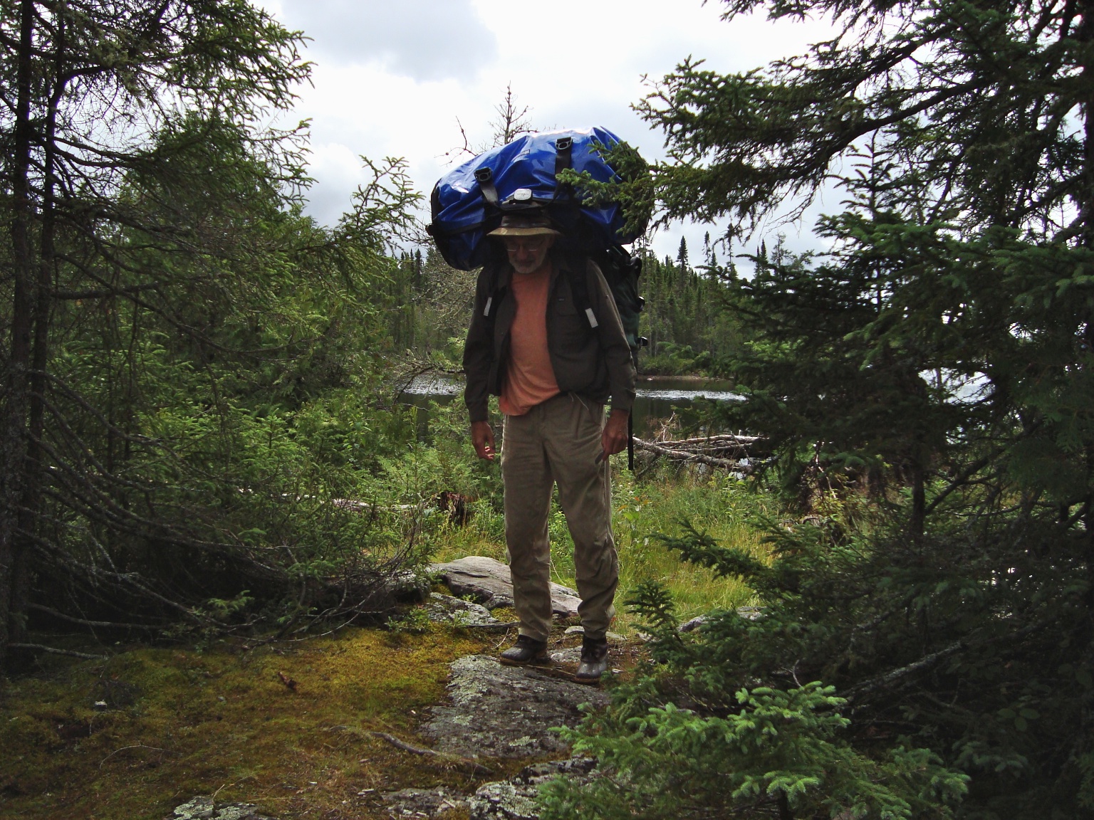
my brother Max double-bagging it on the portage trail
Our portages involve the canoe and paddles and four bags – the two 110-liter Hooligan packs (updated Duluth packs), a Woods pack (a Canadian-made version of the Duluth), and a large North Face duffel bag. Max will take a Hooligan pack and the duffel all the way to the end of the portage while I carry the other two bags and four paddles at what seems like halfway. Leaving them on the side of the trail, I head back for the canoe. By the time I get back to the canoe, Max has reached the end of the portage and is starting to head back for the packs that I left halfway. If we meet at the place where I left the packs, we know that we are pretty close to figuring out the halfway point! Each one of us ends up walking the distance of the portage trail twice per carry.
Given the figures above, it looks like we have about 33 kilometres of walking to do, with three-quarters of that carrying something. Now that we have that 42-lb. Swift Kevlar/carbon canoe, getting to carry it will represent the easiest of the portage options next to carrying nothing!
“If The Shit Hits The Fan”:
If an emergency situation should arise, we may be able to head to a nearby outpost for help. These outposts are run by outfitters based in the Armstrong area and often have visitors booked in for a week of fishing. If people are there, they may well have a satellite phone available. While we certainly do not expect to have to seek help, it doesn’t hurt to know exactly where the outposts are located – just in case. We’re hoping that the biggest emergency we have to report is that our SPOT Connect satellite tracker (and one-way email communicator) is not working because we ran out of batteries. Here is a Google map of the lakes with available outposts we’ll pass en route.
Mattice Lake Outfitters and Wilderness North are two of the outfitters with the biggest presence in the territory we’ll be paddling through. Links to the various outposts can be found here – Rockcliff, Miminiska, Auger, Hurst, Whiteclay, Pickett, Butland, Ratte (2017 update – The last two no longer have a web presence!)
Useful Links
Our route is not original! It is pretty much a copy of the one that CIIcanoe describes in his epic series of posts from 2009 entitled 21 Day Canoe Trip To the “Little North”. He and his partner Dave started their trip in Pashkokogan Lake, just west of Greenbush Lake, which is the headwaters of the Misehkow River. They spent their first two days covering the 53 kilometres to Rockcliff Lake. This is where we pick up their route and follow it to the end. Relevant bits of info on the route and the portages from CIIcanoe’s report will be posted on the digital copies of our maps before I run off a couple of paper sets that will come along for the ride.
A shout-out to CIIcanoe (aka Chuck Ryan) and his paddling partner Dave Phillips (aka djrocks) – thanks for the scouting report and the inspiration! We do hope that the weather is kinder to us and will be very happy not to have to deal with the high water levels that you experienced.
It is possible to get to the starting point on the Misehkow River at Rockcliff Lake from Flindt Landing, Allanwater Ridge, or even Caribou Lake. It would involve at least a one-week paddle up the Palisade River from Kenoji Lake to Burntrock Lake and then some tough slogging NW to Rockcliff. (The Reid/Grand book mentioned below describes one of these routes to the Misehkow.) We decided to forego this preamble and use the week instead to paddle in areas where we have not yet been. Check out this YouTube video (here) of a bush plane flying over the Wabakimi boreal forest. It looks like it is Jonny Jelinski’s flying out of his Allanwater Bridge Lodge property – perhaps to one of his outposts.

Dehavilland Beaver float plane – the 45-minute ride will save us a week of paddling! See here for the image source and more info on this legendary plane. See this page at the Canadian Aviation and Space Museum website for still more details.
This meant arranging a forty-five-minute ride in Don Elliott’s Beaver from his base on Mattice Lake to Rockcliff Lake. Don and his wife Brenda run not only a bush plane service but a complete outfitters’ service for fishermen and paddlers. We’ll just be getting a ride and a shuttle at the end of the trip but Mattice Lake Outfitters can do it all for you – from outposts to fishing boats to canoes to gear to permits to food to maps to drop-offs …well, you get the idea! Check out their website here for the complete list of services offered.
Talking about maps, this year marks the third time we’ve used the excellent map sets that Laurence Mills puts together. See this link – wabakmimaps.com – for more information. [Note: link not working in May 2017}
We also seem to be shadowing the Ken Kokanie “Le Petit Nord” exploration team! No sooner does he post the annotated map set for his most recent adventure at kokanie.ca (sadly the link is no longer alive) than we have checked it out and incorporated it into our upcoming plans. It is no different this time. See here for his comprehensive 2012 trip package for the Albany from Osnaburgh Lake to Miminiska Lake. We will make use of the maps from the point where the Misehkow meets the Albany all the way down to Miminiska Lake.
The classic Canoeing Ontario’s Rivers by Ron Reid and Janet Grand (first published in 1985 with a reprint in 1994) ) has an 18-page chapter entitled “The Misehkow” which provides an overview of their trip –
- from the CN tracks just west of Collins down to Wabakimi Lake and then over to Burntrock Lake.
- From there they made their way to Rockcliff Lake and the beginning of the Misehkow River.
- They paddled the Misehkow down to the Albany
- and then followed it downriver to their take-out point at Fort Hope, a bit further east than Petawanga Lake where we will be heading back south.
It has been thirty years since they recorded the details of their trip but there is lots of useful information to be had. I’m glad I pulled it down from its place in the canoeing section of my little library and took a look at the table of contents!

front cover of the Reid-Grand guidebook
The myccr.com site was also scoured for any relevant threads. Some that I culled for potentially useful information included these –
Wabakimi – Cliff Lake thread from 2006 – with 18 posts including a few from Allan Jacobs, from back in the day when he wasn’t stuck in the head office dealing with the flood of trip reports for the myccr.com website pouring his way!
Trip Report on Allanwater/Ogoki/Raymond/Pikitigushi by Ben Gervais in 2006. The section of the report from Whiteclay Lake to the end has useful information on portages and more.
First, it was the fur trade. Then it was lumber and minerals. The economy of the Canadian Shield has been built on a sequence of resource extraction activities. We’ll see some signs of this as we paddle down the Misehkow, the site in recent years of mineral exploration. I came across this interesting (but admittedly incomprehensible at times because of the geology-specific language!) – Technical Report: Geology and Mineralization of the Misehkow River Property (2008). It explains the activity that CIIcanoe noted as they paddled north from Iron Falls on the Misehkow in August of 2009, given that the Jiminex mining claims are staked in an eight-kilometre area along the river in this area. It’s worth a look.
If you’re into fishing then this link to Miminiska Lodge’s map of a dozen great fishing spots from Upper Eskakwa Falls all the way to Miminiska Falls and Petawanga Lake will be of use. I’ll admit that we are not into fishing but this stretch of the Albany seems to get rave reviews from those who are.
This trip report by finnbay from their 2006 paddle down the Albany has dozens of fishing-related pix and lots of commentary on fishing spots, as well as some excellent all-around info and great photos.
myccr.com has an interesting thread from 2006 entitled Wabakimi Pictograph Locations with some thought-provoking arguments about what purpose the rock paintings served and whether or not their locations should be made public and appreciated by all who took the time to paddle to them.

We are quite excited to be paddling through Cliff Lake. If you check the day-by-day plan above you’ll notice we set aside an entire day to explore the lake. The reason? On the rock face of the cliffs surrounding the lake are numerous native pictographs, some still clearly visible after hundreds of years of exposure. A copy of Reading Rock Art: Interpreting the Indian Rock Paintings of the Canadian Shield (3rd printing, 2009) by Grace Rajnovich has deepened my understanding and appreciation of the painted icons, examples of which we have already paddled by at Fairy Point on Lake Missinaibi and on Diamond Lake in Temagami.

Temagami’s Diamond Lake pictographs
If you want to preview Rajnovich’s book, check out the Google Books preview here. You can read all of chapters 1 and 3 – just enough to get you to order the whole thing! The only thing that is missing from the book are some examples from Cliff Lake! I hope to come back with enough to create an entire post dedicated to the Cliff Lake pictographs.

the front cover of a classic
There is also an out-of-print book first published in 1962 with a second edition in 1967. Indian Rock Paintings of the Great Lakes, was researched, written, and illustrated by Selwyn Dewdney and has a final chapter by Kenneth Kidd entitled “Anthropological Background”. It may be difficult to find. Luckily, the Toronto Public Library system has a couple of copies. I received a copy (the 1973 reprint) after a brief wait and spent a few enjoyable hours with it.
The following maps from the book make clear why in our thirty years of canoe tripping in the northeastern part of Ontario we really haven’t had the chance to paddle by very many pictographs. Quetico and the Lake of the Woods area contain the majority of the identified sites.

Indian Rock Paintings of the Canadian Shield map – from Lake Missinaibi to Lake Winnipeg

Indian Rock Paintings of the Canadian Shield map – from Lake Missinaibi east into Quebec
While the map work is from the early 1960’s it probably indicates most of the currently known pictograph and petroglyph sites. Something we hope to do before this summer’s trip is visiting Bon Echo Park for southern Ontario’s largest collection of pictographs; on the way there we could also visit the petroglyph site just east of Peterborough, apparently the most impressive in all of Canada – and pay another visit to the Canadian Canoe Museum, truly a pilgrimage center for canoe devotees! See here for a Google map to locate the sites mentioned above.
Re: the pictographs. I ended up creating a new post specifically on the rock paintings, focussing on sources of information and on a list of lakes and rivers where they can be found. Check out Indian Pictographs of the Canadian Shield if you want more information.
Update:
We are back from our paddle around the edges of Wabakimi Provincial Park, truly a great place to paddle made easier by the great work being done by Phil Cotton’s Wabakimi Project. While the folks at home followed us along thanks to our SPOT Connect, the only humans we saw were one fishing boat on WhiteClay Lake and float planes parked in front of outposts at Hurst and Felsia Lakes, all during a single day of our two-week-plus 350 km paddle. We did not meet any other canoe trippers.
It will take a while to decompress and write up a trip report but in the meantime, here is a random collection of impressions that will give you an idea of how it went:
The number of no-paddle Rain Days – one. We spent it on Auger Lake on a campsite indicated on a Wabakimi Project-supplied map.
Best campsite – the site on Cliff Lake facing the 250-meter long rock wall on the west shore about a third of the way down the lake as you enter from the north
The site at the south end of Butland Lake was also special and had all the ingredients we look for – that sloped rock front area, a flat area sheltered from the wind for our 4-person MEC Wanderer, easy exit for the canoe, breezy point.
Steepest Portage: Witchwood Lake to Whiteclay Bay. Starts off with a heart rate pumper before levelling off a bit. We’d include the Bad Medicine Lake portage but it is only bad if you are coming from the south.
Oddest Lunch Spots: The abandoned beaver lodge on the Misenkow since there are so few places to stop and maybe the flat rock in the Albany before Eskakwa Falls.
Most Dramatic Portage: Going from Cliff Lake to Bad Medicine Lake takes you up an incline (not as steep as Witchwood Lake) and levels off with the rapids as background entertainment. Some additional up and down and then at the end a steep decline with a narrow footpath section followed by a rapid drop to the put-in point. The bonus is a dramatic cliff face just across from you. Made a nice lunch spot!
The most poorly maintained portage trail – the 1.4 km one into Pikitigushi Lake from Derraugh Lake. It is seriously overgrown. We still can’t figure out why it would be in such bad shape when the ones before it are pretty good.
Biggest Single Day of Paddling – Day 1 – 42 km from Rockcliff Lake to Iron Falls. After lunch at a good potential campsite, we pressed on, hoping to find something before five. We got to Iron Falls at about 8:30, not having seen anything with campsite potential and having spent some time looking for the start of portage trails.
Most Impressive Set of Rapids/Falls: Eskakwa Falls. (Well, maybe Snake Falls too!) What a great photo op. From the portage put-in you can walk right back along the edge of the falls to the top, with stunning views all over. Both are on the Albany River after it and the Misehkow meet.
Top Speed reached; 14 km/hour according to Mr. Garmin thanks to the swifts we were going down along with the wind going our way and the contributions from our paddles. The stretch of the Misehkow River coming into the Albany, the Albany River below Miminiska Falls, and even a stretch of the Pikitigushi River near the end of the trip. Always a buzz!
Worst wind day – the day we approached Lake Miminiska from Howells Lake. The NW wind gave us every reason to get off the water at 1 p.m.; we landed on a nice strip of sand beach on the south shore and carved out a serviceable campsite tucked in a sheltered-from-the-wind spot just off the beach.
The Single most challenging day – the eight hours that we spent covering the 11 kilometres from the mouth of Petawa Creek to the top of Auger Lake. Other than the portage trails at the beginning and end of the creek – both worked on by Cotton’s crew last summer, I think – there are no portages. Blowdown and deadfall would make carving portage trails to get around all the rapids an entire summer project! The only answer – tracking right up the creek – over the deadfall and sweepers. The first half, while not easy, sucks you in; then the second half comes at you with faster water, more difficult rapids, and more creek-crossing deadfall. The creek also took away a prized Auggie Lolk paddle we bought from him in 1987. Could that have been a maymaygwayshi we saw using the paddle as a surfboard as he floated on the top of the waves? I guess we won’t be seeing it again! But if you do find it let us know.
Best Stretch for Moose Encounters: We saw five moose on the Misehkow over a 3 ½ day span. The turns in the river mean that you often surprise the moose as you come around the corner. On the Witchwood River, we also came to about 25 meters from the biggest bull moose we have ever seen, while we surprised a moose and her calf at about 10 meters on the Pikitigushi. Bears – zero. Eagles – every day. Much of the Misehkow, The Witchwood, and the Raymond Rivers are lined with the reeds and grasses the moose graze on – “moose country”.
The day we used the word “Wow” most often: we paddled around Cliff Lake with the vertical rock faces towering over us. It reminded us of the vertical rock on the small lake on the Kopka just before the last of the portages that takes you around the falls; it is just that Cliff Lake has way more of it and it is much higher. To top it off, we saw more pictographs on Cliff Lake than we have seen in all of our previous canoe trips put together – and some of them are in pretty good shape, even if many are smudged and all but gone. We spent about five hours taking in the energy exuded by the rock faces and their ochre paintings. Truly memorable.
The following posts describe different segments of our trip. Check them out for more info –
Canoeing Wabakimi’s Misehkow River
Paddling the Albany River (From the Mouth of the Misehkow to Petawanga Lake)
Paddling The Albany River (From the Mouth of the Misehkow to Petawanga Lake)
Up Wabakimi’s Petawa Creek Without A Paddle
Paddling From Auger Lake to Felsia Lake (The Mouth of the Witchwood River)
Paddling From Auger Lake to Felsia Lake (The Mouth of The Witchwood River System)
A Two_Day Paddle Up Wabakimi’s Witchwood River System
Up Wabakimi’s Raymond River to Cliff Lake
Down Wabakimi’s Pikitigushi River From Cliff Lake
A few years later we completed the Pikitigushi down to Lake Nipigon. The following post has the details –
Down The Pikitigushi From The Bear Camp To Lake Nipigon
Down The Pikitigushi River From Cliff Lake To Lake Nipigon: From The Bear Camp To Windigo Bay
Hi there,
I head up the marketing department at Wilderness North, and yes we do have multiple places for you should you require services or want to ditch the tent for a night in the cabin. You should check out our website and take a look at some of the maps under destinations. There are a few that coincide with your rout. I am also incredibly interested in hearing about your journey down the Pikitigushi river system. Wilderness North operates two trappers cabins one on Butland and the other on Rattie. We are looking into developing a package for guests to go on a day trip from Striker’s Point Lodge on Whitewater Lake following your same route -we would be flying them via a Beaver to either Butland or Rattie and have guests end up at the other end to spend a night in the trapper’s cabin.
Hope to hear from you soon,
Robert
Robert, I did check out the Wilderness North website! See the post for links to the Wilderness North site and reference to your various cabins.
I am not clear about this trapper’s cabin you mention – I take it that it is located at the CN stop at Mud River? In your Lodge section you have it listed as North Nipigon Lodge, which you named the building you apparently bought in 2004. What is not clear is if the place is operational – the info window just says that you are refurbishing it.
Also of interest is if there are any other inhabited buidlngs at Mud River. The Google Earth satellite image seems to show a number of structures, although it is not really clear.
Would you have any information about navigating the Pikitigushi River from Pikitigushi Lake on down to Mud River? There is an indication of a 2 km portage that cuts off the long eastern loop of the meandering river; I do know that there are a couple of portages on the last stretch of the river before Mud River.
Given your Butland Lake and Ratte Lake cabins, as well as what might be a cabin at the CN tracks at Mud River, a canoeing package that took paddlers from Butland to Mud River would be a nice little adventure. The opportunity to see the petroglyphs at Cliff Lake would be a hook to add to the great fishing possibilities and the common sightings of moose in the height of land area between Butland and Cliff. BTW – you guys are the only ones who write Ratte with an i -i.e. Rattie! Is there a story there?
A few more questions – would a stay at the cabin have to be arranged beforehand for a specific day or would we be able to make use of it on whatever day we got there -trip plans don’t always work out when they collide with reality! How much would you be asking per night?
Thanks for the info. I appreciate the time you put into this.