Previous Post: Down The Ogoki From Whiteclay Lake to Two Mile Bay
We spent 3 days on the Ogoki Reservoir, first paddling from Two Mile Bay to Eight Flume Falls and then the almost 50 km. to the east end of the reservoir at Waboose Falls (and Dam) before heading to the South Summit Dam south of Mojikit Lake.

Day 10: From Eight Flume Falls To “Moose Crossing”
-
- distance: 28 km
- time: 7.5 h
- portages/rapids: 0/0
- weather: overcast, cloudy with little wind for most of the day.
- campsite: ~60m from shore, possible multi 1 x 2p sites plus a couple 1 x 4p
- Natural Resources Canada archived 1:50000 topo maps: Whiteclay Lake 052 I 15 and d’Orsonnens Lake 052 I 16.
- See Toporama (here) for NRC’s current interactive coloured mapping and print what you need.

Day 10 of our trip – and the first full day on the reservoir
We left our Two Mile Bay campsite (the only one we did not take a photo of and one that neither of us can even describe!) and headed west to check out Eight Flume Falls. On our way, we would paddle past more reminders of the impact of the Waboose Dam some fifty kilometers downriver. As we have seen at the top of Two Mile Bay, there were more remnant stumps on the land that had been flooded in the early 1940s.

taking in the 80-year-old stumps in the Ogoki Reservoir at the bottom of Two Mile Bay
Eight Flume Falls
We had come down the Two Mile Bay route because of what seems to be the general view that it is an easier – and safer – entry into the Reservoir. The previous post describes the Two Mile Bay route; while it is also quite scenic and perhaps “safer” since there is no whitewater to deal with, I am not so sure about the “easier” part.

Eight Flume Falls and Two Mile Bay Portages
As we paddled towards the bottom of Eight Flume Island, we saw a couple of beached canoes. Fellow canoe trippers – a Toronto-area YMCA Pine Crest group of eight mid-teenagers with a couple of leaders in their early to mid-20s! They had come down the northeast arm of Whiteclay Lake from the Witchwood River the day before and then took the Eight Flume route while we were doing the two portages into Two Mile Bay!
They were all veterans of previous Pince Crest canoe trips and were as surprised to see us as we were to see them. Other than the father/daughter combo fishing at the bottom of the first set of rapids out of Whitewater Lake, they were the only paddlers we saw in our 14 days out.

YMCA Pine Crest canoe at the Ogoki’s Eight Flume Falls campsite
It is always great to see a new generation of wilderness trippers doing what we love to do! This day was one they had made into a rest day, a great choice since they got to enjoy a very scenic slice of Wabakimi. Some of them had plans to run the bottom rapids later on in the day.
[A few days later we would meet the Pine Crest crew again on Stork Lake below the South Summit Dam!]

a satellite image of Eight Flume – high water conditions / red line indicates portage trail
We walked through the edge of their campsite and up the portage trail as far as we could. The closer we got to the top the worse the shape of the trail, perhaps due to the fact that
- it is really a high-water portage trail and
- is used by very few paddlers in any given year.
Here we were in late August of a low-water year and descent via the right channel looked to be pretty straightforward – certainly not the “hazardous” that may apply with early-season high-water conditions. Given that Eight Flume Falls is within the Wabakimi Park boundaries, perhaps an occasional visit by a Park portage trail maintenance crew would be in order!

the right and left channels on the east side of Eight Flume Island
To give you an idea of what it looked like, I’ve arranged the images below starting from near the top (the north end) of the right channel down to the bottom and finally over to the bottom of the left channel.

as far as we went up the Ogoki Eight Flume Falls portage trail

a chute at the Ogoki’s Eight Flume Falls


panorama of the bottom stretch of Eight Flume Falls’ right channel

Eight Flume Falls area – beached canoes on the right channel

the Ogoki’s Eight Flume Falls – the final drop on the right channel
The Natural Resources Canada Toporama website provides a.s.l. (above sea level) figures. While Whiteclay Lake is at 329 meters, the Ogoki Reservoir a.s.l. is given as 327 meters. If the figures are accurate, there is a mere 2-meter drop at Eight Flume Falls. Contrast that with
- the 6-meter drop from Whitewater Lake to Whiteclay Lake or
- the 8-meter drop from Wabakimi Lake to Kenoji Lake!
Admittedly the 2-meter drop at Eight Flume comes in a more compressed space – and we did get the sense that the 2-meter NRC figure is a bit of an underestimate. By chance, I was looking at a surface geology map superimposed on a topo (Map 23 “Thunder Bay”) put out by the Ontario Dept of Lands and Forests in 1963. It has the following figures: Whiteclay at 1094′ and the Ogoki Reservoir 1079″ for a difference of 15′ or 4.6 meters.


the campsite a the bottom of the right channel of the Ogoki’s eight flume falls and the end of the channel coming in from the left
In any case, coming down the Ogoki to Eight Flume Falls would put you exactly where you would want to be – a great campsite at the bottom of the Falls and an entry point to The Ogoki Reservoir that would probably require less effort than the Two Mile Bay route. If we are ever back this way, it will be the route we choose.
In the meanwhile, if you have been down via Eight Flume, any comments you care to share would be appreciated and make more clear what is involved. I will note that we were seeing it at the end of August in a low-water year. Coming down in early July some other year might present paddlers with a different-looking stretch of whitewater, rapids, and falls.

the bottom of the Ogoki’s Eight Flume Falls right channel and the left channel in the distance

two Toronto-area YMCA Pine Crest canoes at the bottom of the Ogoki’s Eight Flume Falls

Hello, Ogoki Reservoir – the bottom of Eight Flume Falls
With our quick tour of the Ogoki’s Eight Flume Falls right channel and the portage trail done, we said goodbye to the Pine Crest crew and headed over to the bottom of the left channel for a different perspective.
Checking Out the Left Channel at Eight Flume Falls
This aerial image from the north shows the left and right channels as they come down to the Reservoir. On our late-August visit, the water was low enough for us to be standing on the rock outcrop ledge at the bottom of the left channel. In the image below it is under water!

the image is from a Mattice Lake Outfitters web page. They have a lodge not far from Eight Flume.
Looking at the left channel in the aerial photo above, it looks like an even easier entry route to the Reservoir than going down the right channel. Again, water levels and current would be key. On our visit, it was quite doable, given a combination of float, line, and lift over.

the bottom of the Ogoki’s left channel at Eight Flume Falls

the bottom of the Ogoki’s left channel and the bottom of the right channel in the background

the Ogoki’s Eight Flume Falls – left channel and right channel merging at the bottom
The Area Flooded by The Waboose Dam:
If the name “Eight Flume” is older than the Ogoki Reservoir, it is possible that some of those flumes – another word for “channels” – may have been submerged with the rising water blocked by the dam. However, given the following map with the grey areas showing what was flooded, it would seem that the area around Eight Flume Falls and Two Mile Bay were less affected. [Then again, see here for some of what we saw at the top of Two Mile Bay the previous day.]

We would see some of the lingering evidence of that flooding over the next two days as we paddled down the reservoir to the Waboose Dam.
 At about 10 a.m. we paddled away from Eight Flume and embraced what we knew would be a long slog down a narrow and shallow Ogoki Reservoir. A half-hour later we stopped for a Clif Bar/Gatorade break just to the east of the Mattice Lake Outfitters island lodge.
We were now no longer in Wabakimi Provincial Park; until we got to the bottom of the South Channel Dam we would be in Mojikit Lake Conservation Reserve, a protected area set up in 2003.

the Mattice Lake Outfitters island lodge not far from Eight Flume Falls
The water was remarkably calm. Over the next six hours, we made easy progress 25 km. down the reservoir, stopping occasionally to stretch our legs and – at the 14 km. count for the day – for a 1 1/4 hr. lunch break in the shade. Here is the beach area where we set up our Helinox chairs and sipped on coffee. Listen to my rain pants as I shuffle along the beach trying to keep the iPhone steady!
A few days later we would meet the Pine Crest campers below the South Summit Dam. They came down the Reservoir on the following day and thanks to the wind and their sails, they said that they did the 34 kilometers to Mojikit Channel in an easy day. Given that winds are usually from the NW or SW, the Reservoir west-east orientation makes it an ideal place to harness that wind!
“Moose Crossing”:
Near the end of our day’s paddle, we passed through a narrow section of the reservoir where the north and south shores almost meet. As we scanned the shoreline for a potential campsite, we saw the Moose Crossing sign that someone had erected.

Day 10 CS – halfway down the Ogoki Reservoir

The sign is perhaps whimsical but it could be the legit local name for the spot! That moose would make use of the almost-touching opposite shores to cross is not hard to believe. Earlier we had paddled past a bay with a Wilderness North outpost called Moose Crossing perhaps because it is fairly close (7 km) to this narrowing of the reservoir.
Then again, moose are strong swimmers and given how shallow much of the reservoir is (or was in late August 2021) they could cross anywhere. In any case, the sign caught our eyes in a fairly desolate landscape. For some reason, the line “The land that God gave to Cain” streamed through my mind a number of times this day and the next as we paddled our way to Waboose Falls!

Moose Crossing sign on the south side of the Ogoki Reservoir
While we noted a fire pit near the sign, we moved on, figuring something better – i.e. more sheltered – would come up. Less than a kilometer later, we approached a set of massive boulders on the south shore. Behind them was a wooded area that looked promising. In the image below you can see what we came up with – there is a bit of apple green tarp visible in the bush about 60 meters in from the shore.

Moose Crossing campsite – the Three Boulders On the Shore
We hopped out and checked it out. Within 45 minutes the tent was up and the canoe was set up to serve as a windscreen for our butane stoves.

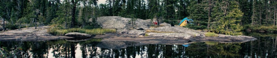
our Day 10 CS on the Ogoki Reservoir’s south shore near “Moose Crossing”

our campsite just one kilometer east from “Moose Crossing”

The Three Boulders – where we stopped for the night

dead tree stumps along the south shore of the Ogoki Reservoir near our campsite
We were happy with the way the day had turned out: we had visited Eight Flume Falls and then paddled halfway down the Ogoki Reservoir. That meant that we would be camping at the Waboose Dam the next day! The next post has the pics and maps, including our walk to the bottom of the portage trail around the totally neutered Waboose Falls.
Next Post: Canoeing The Ogoki Reservoir – From “Moose Crossing” To Waboose Dam