
Table of Contents:
- Day 1: From Toronto to Hartley Bay to A Pickerel River Campsite
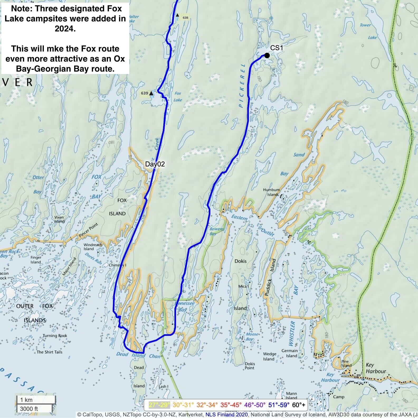
- Day 2: Down The Pickerel & Up the Fox Route to Pickerel Bay
- Day 3: Pickerel Bay Campsite to Georgian Bay
- Day 4: Georgian Bay To The Bottom Of The Old Voyageur Channel
- Day 5: From The Old Voyageur Channel to Whitefish Bay
- Day 6: Whitefish Bay to the Wanapitei River’s Sturgeon Chutes
- Day 7: Sturgeon Chutes to Hartley Bay
- 1. Federal Government NRC Topo Maps – free
- 2. Crawshay’s Topo Canada iOS App – free.
- 3. ATLOGIS Canada Topo Maps for Android OS: free/$14.
- 4. Friends of French River P.P. Map – $15
- 5. Maps By Jeff – $20
Ontario Parks Online Backcountry Permit
More Information And Inspiration
- Kas Stone. Paddling and Hiking The Georgian Bay Coast.
- Toni Harting. French River: Canoeing The River of the Stick Wavers
- TV Ontario’s Tripping Series – The French River.
Our Other Georgian Bay/French River Trip Reports
—————–
Introduction:
It was less than a decade ago that we stumbled upon the NE corner of Georgian Bay as a paddler’s paradise.
- 2016 – Philip Edward Island
- 2017 – Chikanishing to Snug Harbour
- 2017 – the French River Delta Area
- 2019 –The French River from Lake Nipissing with the last 5 days in the delta
This early fall, keen on a destination that did not require a day or two to get to the put-in, a return to the French River Delta with Hartley Bay Marina as the put-in spot was an easy choice. We’d get to experience again the Delta’s scenic eye candy and contemplate its many layers of history.
Our previous visit in June 2019 coincided with extremely high water conditions. We wondered what we would find in early October. To create some novelty, we decided to do the channels and outlets of the Delta in the reverse direction we had done them in before –
- the Pickerel River from Pickerel Bay
- Fox Creek/Lake/Bay
- the Canoe Channel/Bass Creek
- the Main Outlet (Dalles and Little Dalles Rapids)
- the Old Voyageur Channel
- the Channel with Boston Falls at its top
Also on our to-do list were visits to
- one of our favourite Delta campsites – 634 on Pickerel Bay
- the now-off-limits boardwalk portage on Bass Creek
- the ruins of the Gauthier Fish Plant on the island near Bad River Point
- the reputed Fort at the top of the Fort Channel,
- the scenic view from the elevated rock at Devil’s Door Rapids
- another look at the remains of French River Village
- a paddle up the Wanapitei River to check out the Sturgeon Chutes
The weather forecast looked great and the many scrapes and gouges on our canoe bottom from our 2023 trip down the Savant River NW of Lake Nipigon had been filled with G-Flex the weekend before.
It was time to head up the 400 to the French River.

canoe bottom g-flex and paint under blue tarp
—————–
The Route: Overview Map

2024 French River Delta Overview
You can access our GPS track at Caltopo – see here and choose export for the GPX or KML file.
—————–
Day 1: Toronto to Hartley Bay to A Pickerel River Campsite
- Date: September 29, 2024
- Distance: 17 km
- Time: 11:20 – 5:20: 6 hrs
- Rapids: none
- Portages: 3
- Weather: hot hot hot shirts off
- Sightings: a dozen motor boats in Hartley Bay; some paddlers at the end of their trip
- Campsite: N45° 57.711′ W80° 45.465′
- Caltopo link to our GPS track for the entire 7-day route

the usual shot – this one from the start of our 2023 journey to Savant Lake in NW Ontario
The image above is the usual one we take at the beginning of a canoe trip. We moved the location from our residential street to something a bit more dramatic for this year’s shot!

The view from Broadview at dawn

We set off at 7:00 a.m., taking a couple of minutes to get that shot of our canoe with the downtown skyline in the background. By 11:30, we were paddling away from the Hartley Bay Marina dock ($10 for dock access). We left the car in the marina parking lot ($15 a day). While there may be no-cost options available, we figured the convenience and security of the marina, as well as its proximity to the delta, were worth the cost.


We had lunch on Pickerel Bay at CS634. The next day on our return via the Fox route we would overnight there, to the confusion of the folks back home. They thought maybe we had forgotten something and had to return!

CS634 on Pickerel Bay FRPP
With lunch done, we headed for the Pickerel River. The final 12-kilometre stretch of the river down to Georgian Bay is seldom travelled, just like our next day’s Fox route. Neither has any cottages, and both require some portaging. The rock-lined narrow stretches, as seen in the image below, make for some enchanting paddling.

down a narrow Pickerel River channel – near CS636

Pickerel River – same channel, a few minutes later
We had come up the west channel in 2017 after one easy portage. However, the low water levels this October – and maybe in the years before – nixed that as an option. We walked down the top of the channel; it was completely dry for as far as we could see! Instead, we headed for the east channel indicated on the Maps By Jeff map; it noted one portage.
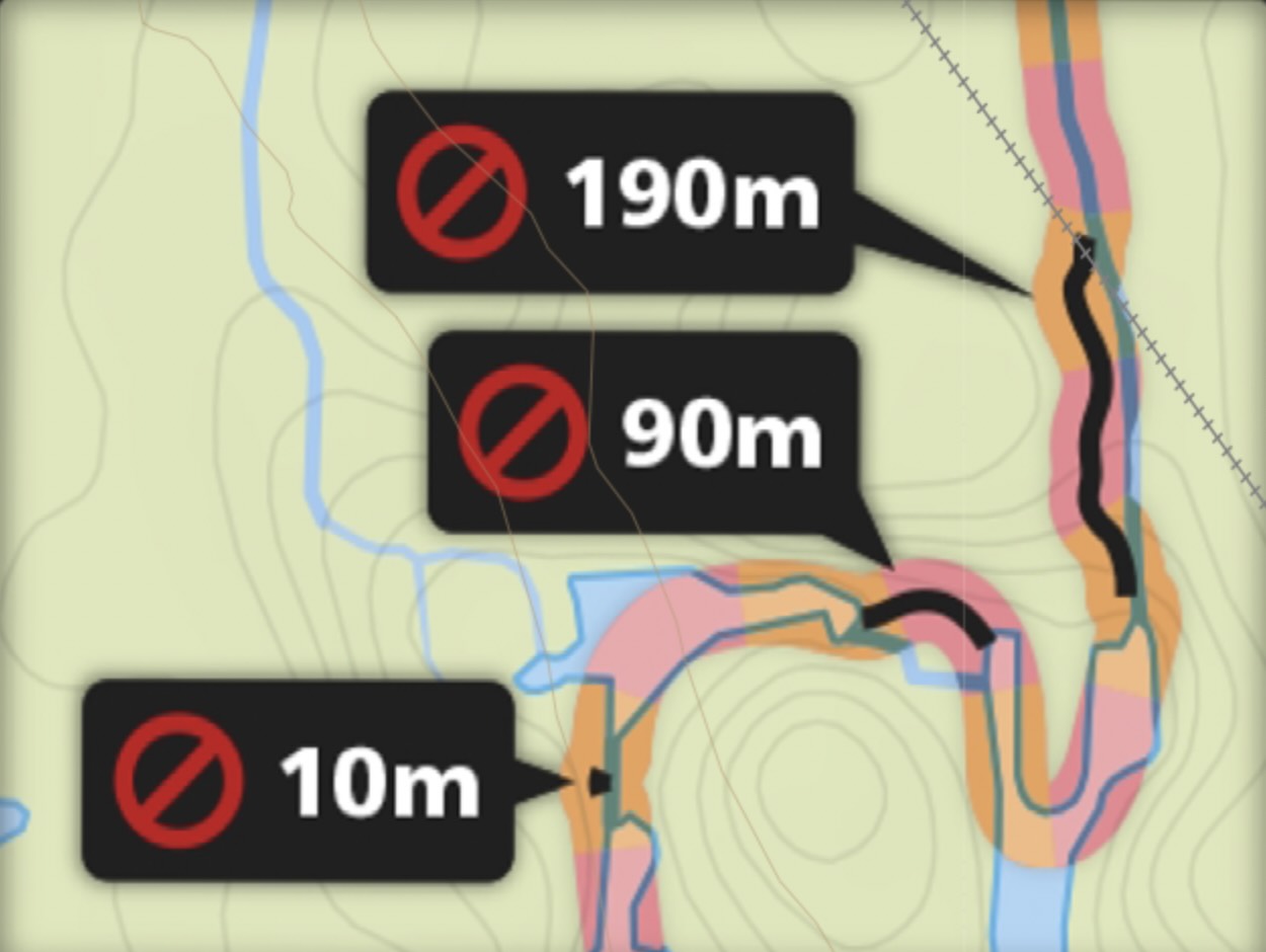
At 3:00, we had been sitting at the top of the completely dry, overgrown west channel. Over the next two hours, we dealt with three obstacles to our forward progress –
- #1 – 85 meters 20 minutes
- #2 – 80 meters 20 minutes
- #3 – 300 meters 60 minutes

We spent 40 minutes dealing with two “portages,” rather than the one indicated on Jeff’s Maps (see here). His map has as one portage the first two we did.
While his route turned west to two shorter portages, we continued south to tackle the longest of the three portages. The route Jeff’s map indicates would probably have been less work!
Shortly after 5, we were at the end of the final and most demanding portage. Before we went into campsite search mode, I figured I’d make a video recording of what we had just hauled our packs and gear and dragged the canoe through. The image below shows the last short section and me walking back to the top of the portage.

Walking back to the put-in of the third and last portage on the lower Pickerel
While we stayed with the water and the marsh below, my video was shot from the edge of the elevated, mostly flat rock outcrop, about 2 or 3 meters above. A bit of work would turn it into a usable portage trail.
Our Day 1 campsite was a decent, unofficial one just past the last of the three Pickerel River portages we had done in the afternoon. We left for the next morning, the rest of the paddle down the Pickerel to Georgian Bay.

panorama of Day 1 CS on the lower Pickerel River

Day 1 CS on the lower Pickerel

sunset on the lower Pickerel
Even though we had started around 11:30, we had put in a solid day’s work – 17 kilometres and three portages. The low water conditions – three or more feet lower than on our last visit – meant that in the following days, we’d get to deal with the consequences again.
—————–
Day 2: Down The Pickerel & Up the Fox to Pickerel Bay
- Date: September 30, 2024
- Distance: 24.1 km
- Time: 8:30 -5:00 pm 8.5 hrs
- Rapids: none
- Portages: 3 on Fox Creek; 1 lift over in the bay
- Weather: sunny and warm
- Sightings:
- Campsite: CS634 on Ox/Pickerel Bay
- Caltopo link to our GPS track for the entire 7-day route

We started the day curious about the pictograph that the Maps by Jeff locates in the narrow channel not far from where we had camped. The site was registered by Thor Conway in 1975 and has the Borden location number BlHe-1.
A note on the map reads –
A low-lying rock that juts into the main channel features an image of a man portaging a canoe.
We came to this rock that seemed to fit the description better than anything else. After scanning the north side of the rock and not seeing any fading image “painted” with the red iron oxide powder used by the Ojibwe, we checked the south face.
The image below shows the south face of the rock. Still no image. We considered the map description – man portaging a canoe. For us, it would be the first-ever pictograph with such a depiction.

possible location of the reputed Pickerel River pictograph
Not seeing any iron oxide marks, we looked at the faint white streaks on the rock face. There are a few examples of traditional Anishinaabe rock images painted in white. The Moose and Stars panel at Fairy Point on Missinaibi Lake comes to mind –

Fairy Point – Moose and Stars Panel
Humans are adept at creating meaning – even where there is none. Staring at this rock, the image of a man carrying a canoe can certainly be imagined, especially if told to look for it. Click on the image below to see what we came up with as we stared at the white paint stains!

A bit of post-trip Googling turned up this shot of the same rock in a Passionate Paddler blog entry from May 2008. In the space where we created a man portaging a canoe, there is what looks like a figure T with downward-sloping ends on the horizontal line, which could represent the overturned canoe. The vertical line would be the paddler!

same rock – photograph from 2008
Yet another example of creating meaning where there is none? Interesting to see that the T-shaped marking has almost completely disappeared over the past 16 years. We figure it was done in modern white paint. Surely this is not the painted image that Thor Conway registered!
Maybe we were not looking at the correct low-lying rock that juts into the main channel. If you have seen the actual pictograph, let me know in the comments below!
————
We switched from our failed pictograph search and continued our paddle down the vertical rock-lined channel. Now we were seeing the results of the 2018 Parry Sound 33 wildfire started by a careless construction crew working on the Henvey Inlet wind turbine project. The 120 sq. km fire stretched as far as the Fox Creek route. Along with charred tree trunks – looking less black than we remembered from our 2019 visit – were more signs of the start of another growth cycle.

Parry Sound 33 Fire of 2018

evidence of 2018’s wildfire along the lower Pickerel River
Seeing an elevated rock outcrop, we decided to stretch our legs and walk to the top to see the view it offered. The two images below are what we came up with!

walking up for a hilltop view of the lower Pickerel

hilltop view looking south on the Pickerel River
By 11:00 a.m., we were making our way to the start of our ascent of the Fox route through the many narrow slivers of rock along the Georgian Bay coast. In the image below, we reached a spot where the only way forward was a quick mini-portage to reach the water on the other side.

The Fox route involves three portages – two at the very top and the one we were now approaching. Before we tackled it, we stopped for a lunch break in the neighbourhood’s one shady spot.

Lunchtime on the Fox Route – our first portage awaits

day 2 lunch in the neighbourhood’s only shady spot
 We had done the portage in the reverse direction (N to S) in June 2019 in very high water conditions. Well, the end of September 2024 presented us with the opposite – we did it first instead of last in a low-water year compounded by end-of-season conditions! Note: We did notice portage markers above a part of the route we took, but ignored them. We may not have made the best choice!
We got started by dragging the canoe about 30 meters across the grass, as shown in the image below.

That brought us to a small stretch of floatable water that we crossed to reach the next obstacle – another carry across a walkable path up to the put-in. The image below shows Max looking at the faint trail we would use to reach the end of the carry.

All in all, it took us about 45 minutes to get the 230-meter drag-paddle-carry portage done. When we got to the put-in, we saw the boat shell that had been there in June 2019. [See 2019 – The Fox Route’s Third Portage for the same portage in high water and done in reverse.]
Yet more 2018 wildfire evidence as we made our way to the portages at the top of Fox Creek, which would take us to Pickerel Bay.


Both portages were much like we remembered, with the additional benefit of someone having marked the trail with a few of the yellow trail direction signs you can get from Chrismar, the map company. A thumbs up to whoever took the time to put them there! They have made a less-travelled but very scenic route to or from Georgian Bay that much better.
We got to CS634 shortly after 5. Since sunset was around 7:10, we got to work putting up the tent and getting supper done while it was still light. We seem to have been so busy that we did not take the time to get some pix of what we think is one of the park’s best campsites. Take a look at our 2019 report to see what we mean –
A Favourite French River Delta Campsite – CS634
—————–
Day 3: Pickerel Bay CS to Georgian Bay
- Date: October 1, 2024
- Distance: 14.5 km
- Time: 8:30 – 12:15 pm 3h:50m
- Rapids: none
- Portages: 2 – Bass Creek
- Weather: Cloudy, overcast, rain around 3 pm
- Sightings: three cottagers at a Bass Lake property
- Campsite: CS730 at the bottom of the Eastern Outlet (Bass Creek)
- Caltopo link to our GPS track for the entire 7-day route

Our weather forecast (courtesy of our Garmin inReach Explorer+) predicted rain starting mid-afternoon, so we set off planning a shorter day so that we’d have the tent and tarps up before it arrived.
As the map above shows, we reached Obstacle Island, where we decided to pull in at the official campsite (CS730). It was about 12:30, and the day was done!
On our way there, we took our first break as we neared CS670 at the SE corner of the Elbow. We were surprised to see a still smouldering log lying outside the fire ring. We hadn’t seen any paddlers that morning – and wouldn’t for the next three days.


CS670 and a smouldering log – south of the Elbow
In 2019, we had come up the Bass Creek route and lined our canoe through a narrow 10-meter section. Well, the image below shows what it looked like this October with four feet less water! 10 minutes and 30 meters later we were paddling south to the final Bass Creek portage.

approaching the Bass Creek life-over from the north


Bass Creek lift-over and portage
Once past the lift-over (mini portage), it was down the narrow channel to the longer portage, the last one before Georgian Bay. Bass Creek is definitely the easiest route for paddlers (canoe or kayak) to access Georgian Bay.


 We got to the put-in of the 100-meter carry expecting to see the dock that had been there five years ago. It was gone – but now there was a new dock on the north side of the creek with the owner’s name on it, While the property is now private, there used to be a boardwalk used by paddlers instead of the two portages we had just done. In the satellite image above you can make out sections of the boardwalk, as well as the roofs of a few buildings.

dock and south end of the now-private Bass Creek boardwalk
Satellite images of the neighbourhood show that the boardwalk still exists. The images above show the dock at the south end and parts of a boardwalk that paddlers once used to get around the falls. The boardwalk replaced a tramway used by a lumber company in the early 1910s to move equipment from the defunct French River Village up to the Pickerel River via Bass Creek to what would become Pickerel Landing Village. [See here for more info.] Carts ran on the fixed tracks of the tramway, but in time, things fell into disrepair. The tramway was eventually replaced by the wooden boardwalk that is now there.
If you have any more info about the property’s history, let me know in the comments. Most of what I’ve learned about the Bass Creek tramway can be found in Kas Stone’s essential book Paddling and Hiking the Georgian Bay Coast.
More scenic paddling down a narrow channel to Georgian Bay and Obstacle Island, and it was time to stop for the day.

down the channel from Bass Creek to Georgian Bay
We travel with two 10’x14′ silnylon tarps,
- one to put over the tent for that extra bit of protection when necessary and
- one over our dining area, usually framed on one side by our overturned canoe
This was the one day of the trip when they proved their worth. Given the forecast for mid-afternoon rain, we stopped for the day around 12:30. The campsite was CS730 on Obstacle Island at the bottom of Bass Creek.
The tent and tent tarp went up immediately; just after the dining tarp went up, the rain started coming down and continued steadily for some time. We listened to the raindrops hitting the tarp as we stretched out in our comfy Helinox chairs and sipped post-lunch coffee.

Obstacle Island campsite

Max fine-tunes the tension of the strings of the tarp over our tent
—————–
Day 4: G’ Bay to the bottom of the Old Voyageur Channel
- Date: October 2, 2024
- Distance: 21 km
- Time: 8:50 – 2:50 6hrs
- Rapids: 0
- Portages: none
- Weather: Cloudy w/sunny periods; calm winds
- Sightings: no motor boats or paddlers; one person at the property E of the Gauthier Fish Plant island
- Campsite: CS830
- Caltopo link to our GPS track for the entire 7-day route

We set off from our Obstacle Island CS with a major decision to make – did we head out to the Bustards or not? The two kilometres from Cantin Point to Tarpot Island are the shortest route to the Bustards, and the wind conditions were certainly favourable. However, the forecast for the next day was much less promising – strong winds with gusts up to 40 km. Not wanting to get windbound, we reluctantly decided to pass up on the offshore islands and head west along the Georgian Bay coast to the Western Channel.
We stopped on the west side of Sand Bay to take a photo of the Bustard lighthouses, which were about 4 kilometres away. Max’s Sony RX80 with its 720mm focal length reach captured the following shot.

The Bustard Rock lighthouses on Max’s Sony HX 80
I went to the opposite end and got the view you see below at 24mm. The lighthouses are specks on the horizon!


the smooth, low-lying rock outcrops of Georgian Bay
A Visit to The Gauthier Fish Packing Plant Ruins
Weaving our way through the almost submerged rock outcrops, we passed by a privately owned island with several well-maintained buildings on it. We saw someone there walking from one building to another as we headed to the nearby island to check out what was left of the Gauthier Fish Packing Plant.

front row seats on Georgian Bay – privately owned island

Maps by Jeff note on the Gauthier Fish Packing Plant ruins
Like the fish station at Highland Home in the Bustard Islands, the Gauthier fish packing plant closed about 60 years ago. Kas Stone, in her chapter on The French River Delta in Paddling and Hiking The Georgian Bay Coast, notes the following factors which led to the collapse of the commercial fisheries on the Bay –
- overfishing
- pollution of the spawning grounds by logging debris
- invasion of the bay by sea lamprey and other non-native species
We rambled around the site, noting the boiler and rusting pieces of other machinery, as well as the foundations of a few buildings.


boiler at Gauthier Fish Packing Plant on Georgian Bay


the concrete foundation of a Gauthier fish plant building

Ruins of Gauthier Fish Packing Plant – Georgian Bay

Gauthier fish plant building foundation
The Gauthier plant ruins are just east of the Lodge Channel. Curious about the several buildings at the top of the channel that our topo map indicated, we paddled up the channel to take a look. We found a small community of perhaps fifteen cottages, all looking in good shape. We wondered whether they were all part of a lodge that still existed or were individually owned.


close-up of some Lodge Channel cottages
Checking Out “The Fort” A Supposed Ambush Location

“The Fort” – boulder deposit
Paddling back to the Bay from the Lodge Channel, we made our way up the Fort Channel. We were headed to a landmark identified by Harting as The Fort, a supposed ambush site used by Indigenous pirates to rob the voyageurs of their trade goods. The site – see below – is a jumble of rocks that may or may not look like a fort, depending on how much you want it to be one!
Again, to quote the best book written about the French River:
On the south shore of the West Cross Channel, close to Black Bay, there is a peculiar collection of tumbled-down rocks where several circular openings seem to have been constructed. This was possibly used as a shelter by Natives lying in ambush for the treasure-filled fur-trade canoes that would pass down the channel, which is quite narrow at this point. This could well be the “Fort” talked about in some old reports and after which the Fort Channel is named. [Harting 32]
The story itself left us skeptical. How often could it have been used as an ambush site before the fur brigades realized there would be trouble up ahead? It is no more amazing an ambush site than countless others they could have picked.
Furthermore, just which Indigenous tribe would be doing the hold-up? If it was an Algonkian (i.e. Anishinaabe) people, they would only be ticking off their many fellow Ojibwe who worked with the French.
If it were a Five Nation Iroquois Haudenosaunee tribe from the upper New York State area, it would seem a long way to come to steal goods that could be taken much closer to home. It would also date its use to the 1600s when the Iroquois were still a military power. By 1700, various Anishinaabek (i.e. Algonkian) peoples controlled southern Ontario.
Two Fur Trader Accounts of the Fort
- John Macdonell 1793
The Journal of the fur trader John Macdonell – found in a collection titled Five Fur Traders of the Northwest– has this entry from June 26, 1793:

See here for a 9.7 Mb pdf file of Macdonell’s Journal.
Macdonnell’s account puts a different spin on the story than Harting’s. For one, it sounds like a one-off ambush and not an oft-used spot; it also makes clear who the attackers were – and also how unsuccessful they were! It would date the attempted ambush around 1740, long after the military power of the Iroquois had been defeated by an alliance of Algonkian-speaking tribes. By 1740, all of southern Ontario was controlled by various Anishinaabek peoples, and it is quite unlikely that the upper New York State Iroquois would have dared venture all the way to the French River Delta.
2. Daniel Harmon 1800
The fur trader Daniel Harmon has yet another account of the indigenous pirates who ambushed westward-bound voyageurs with their trade goods. His May 24, 1800 diary entry reads:

Download a 19.7 Mb pdf file of Harmon’s A Journal of The Voyages And Travels In The Interior of North America.

His account has the bandits as Anishinaabe – Ojibwe or Cree – and implies that the spot was used for an extended period before “the Good Indians” decided enough was enough. While Macdonnell places the incident(s) in the French period, Harmon’s mention of the NW Co. puts it post-Conquest, sometime after 1770. The Montreal-based NW Co. was established in the late 1770s.
We had somehow missed seeing the so-called fort on our 2019 visit, having paddled up the wrong channel! This time, we made sure we got to the site and spent some time examining it.


The Fort – a closer-up view

The Fort – a view from the top
The nearby presence of other boulder and gravel deposits, and even a bay named Gravel, provides a clue to the origin of the jumble of rocks which the voyageurs paddled by and turned into a fort.
Much more fantastical to them would have been the story we tell about a two-kilometre-thick ice sheet covering the area for thousands of years, while subglacial streams moved, broke, and ground the rocks into pieces as small as grains of sand!

from The Fort back to the canoe
Note: The Fort material is mostly a cut-and-paste from our 2019 trip report. See here –
Canoeing The French River From Top To Bottom: Days 8 & 9 – Across the Delta From East To West
From the Fort location, we headed east on the West Cross Channel to the bottom of the Old Voyageur Channel and CS830, a nice site complete with trails to a couple of vistas of the neighbourhood. As with all the sites we camped at on the trip, this was litter-free.


a messy kitchen table at CS830

hilltop view of the end of the Old Voyageur Channel
—————–
Day 5: From Old Voyageur Channel to Whitefish Bay
- Date: October 3, 2024
- Distance: 15 km
- Time: 9:00 – 4:00 pm. 7 hrs
- Rapids: 0
- Portages: 3 – low water extended in the Cross Channel
- Weather: sunny w/ breeze; stiff in the bay
- Sightings:
- Campsite: CS803 on Whitefish Bay’s west side
- Toilet Box: none found
- Caltopo link to our GPS track for the entire 7-day route

We set off from our campsite at the bottom of the historic Old Voyageur Channel on the French River, expecting to have to portage our canoe past La Dalle, the long set of swifts we had come down a couple of times before, enjoying the ride as we did so.

Looking up the Old Voyageur Channel from CS830
However, it was late in the season – October 2 – and water levels were so low that we were able to paddle up the swifts with no effort. We were so amazed by our good fortune that we turned back down to the start of La Dalle and paddled up a second time!
It really is a scenic stretch of the delta made more special by the echoes of the voyageurs in their canôts du Maitre coming down. I’ve always wondered if La Dalle is what Frances Ane Hopkins had in mind when she painted the following scene –


a section of La Dalle on the French River’s Old Voyageur Channel
After our double ascent of La Dalle, it was on to Palmer Rapids and another case of us paddling up the rapids with no sweat! That left only one more obstacle at the very top of the Old Voyageur Channel, La Petite Faucille. It would have been the one set of rapids the voyageurs would have had to do on their way to La Prairie, their camping spot for the end of a long day that began at the very top of the French River.
The following pics show what we found as we approached. There was no water coming over the drop!


the bottom of La Petite Faucille Rapids

La Petite Faucille in very low water
The traditional portage is on river left; having done it a couple of times, we knew the drill and were soon up and over. Before continuing on up to the top of the Old Voyageur Channel, we paddled into the bay to the east of the channel to check out the views. We were not disappointed.

Screenshot
Boston Falls sits at the top of a nameless channel that goes right down to the west cross channel. We had come up the channel in 2019 and were now heading down. Instead of the Boston Falls portage indicated on the Maps by Jeff map, we took a side channel, which took us to a nameless set of falls below Boston Falls.

Like everything else this morning, it was characterized by the lack of water! An easy 70-meter carry over a flat stretch of rock outcrop brought us to the put-in on the other side. Thirty minutes and a couple of dead ends later, we were in the cross channel.

Falls below Boston Falls – a mere trickle of water coming down

another view of no-name falls below Boston Falls

Once down the west section of the Cross Channel, we paddled east towards Devil’s Door Rapids. We had already done the portage around the rapids twice. We wondered what the low water conditions we were experiencing would do to the 1-meter-plus drop we had seen before.

With our canoe at the start of the 50-meter straight up-and-down portage, we scampered up the rock to get a view from above. The 4′ drop was not there, and what was there we could easily ride through. We went back down to the canoe, relieved that a portage was not necessary. Heading to the left side of the rapids, we were through in a second and on our way to the east section of the cross channel.

a view of Devil’s Door Rapids from above

The Cross Channel route to avoid Georgian Bay wind and waves
As we got closer to the open waters of Georgian Bay, we had to deal with strong SSW wind, strong enough that we could not land our canoe when we turned into Whitefish Bay. After first heading to the other side of the bay to a spot where we could land the canoe and not finding anything suitable, we made our way back. This time, we were lucky to come upon a spot where we could land.
We found an excellent sheltered and, from appearances, seldom-used campsite. Like all the others we used, it was tidy and free of litter.

Georgian Bay – Whitefish Bay CS803

Whitefish Bay CS803 – nicely sheltered
—————–
Day 6: Whitefish Bay to Sturgeon Chutes
- Date: October 4, 2024
- Distance: 24 km
- Time: 8:30 – 3:30 pm. 7 hrs
- Rapids: 0
- Portages: 1
- Weather: sunny, some clouds, warm
- Sightings:
- Campsite: CS647 on the east side of the Wanapitei River’s Sturgeon Chutes
- Toilet Box: yes
- Caltopo link to our GPS track for the entire 7-day route


Our last full day in the Park and, knowing it would be our last paddling day of 2024, we made it a big one, 24 km up to the northernmost campsite in the French River Delta. That would be CS647 on the east side of the Sturgeon Chutes on the Wanapitei River.
At the bottom of the Main Outlet, the preferred route of the voyageurs on their way to the west end of Lake Superior, we stopped for a moment to look at the Henvey Inlet wind turbines about twenty kilometres away. There are 87 in all, which have been at work since 2019. The Henvey Inlet First Nation, as a 50% partner in the operation, apparently earns about $ 10 million. A year from the electricity generated.

Morning view of the Henvey F.N.:/Pattern Energy wind turbines
We continued up the Main Outlet, seeing evidence of what had been, for a quarter-century, a thriving resource-extraction community. By 1910, however, the lumber boom was over and French River Village faded away, burnt down like the Queen’s Hotel or hauled off to be reused elsewhere, with only a few ruins and a lighthouse remaining.

French River Village ruins
We soon came to Loading Cove, the spot where the lumber would be transferred to waiting ships for delivery to various Lake Huron towns on both sides of the border. One hundred years after the demise of French River Village, nature has seemingly reclaimed the space!


As we paddled past the cove, we looked at the solitary cottage sitting near the outside corner. What we didn’t see were the other buildings behind it screened by the bush. A satellite image of the area shows this –

The following post has more info and some historical images of French River Village:
Across the remains of French River Village is Camp McIntosh, the only still-operating fishing lodge on Georgian Bay in the French River Delta. The other one, Georgian Bay Fishing Camp, closed shortly after its owner’s death. [There is also Bear’s Den Lodge, but it is up in Hartley Bay.]

The McIntosh Camp below Dalles Rapids on the French River
Just above Camp McIntosh are the Little Dalles Rapids. Shortly after we had paddled up to them, Max, the mapkeeper, asked me when they were coming up! He was surprised to hear we were already on our way to Dalles Rapids.

approaching Little Dalles Rapids from the bottom
Our last portage of the trip was the one around Dalles Rapids. The trail is well-used. Max took one canoe pack, one duffel, and the paddles, and walked them 350 meters to the other end; I took the other canoe pack and duffel, and my camera bag, and walked them halfway, using my Garmin watch to calculate the halfway point. Then I went back for the canoe.
For one last time this year, I got to bounce 60 pounds off my left thigh, lift it over my head, and set it on my shoulders. When I got to the halfway point of the portage, Max was just arriving, ready to pick up the packs I had dumped there. Good timing!

canoe loaded at the top of the Dalles Rapids portage
Then it was on up the Main Outlet to access the mouth of the Wanapitei River. We had paddled up the mouth of the river to The Forks the last time we were here, and were looking forward to doing it again.
After a few days on or close to Georgian Bay, it is a totally different experience. Instead of bare rock and scraggy pine, we were entering a deciduous forest mostly free of rock outcrops until we arrived at our campsite for the night at Sturgeon Chutes.

The Wanapitei River below the Sturgeon Chutes
We would camp on the side of the last set of chutes; the next morning, we walked to the upper set along a scenic high trail.


satellite view of the Sturgeon Chutes, the last dramatic set of falls on the Wanapitei River
There are three designated campsites as you near the Sturgeon Chutes. The first one, CS645, is a complete dud hidden under a meter of bush and in severe need of some maintenance. No fire ring or thunderbox was spotted in my quick look at the site. Given how far it is from the chutes, you’d have to wonder why anyone would choose to camp there.
The next one, CS646, is in fine shape with flat space for more than one tent. We put a hold on it while we paddled over to the northernmost one, CS647, on the east side of the Sturgeon Chutes. In the end, its proximity to the chutes and a decent spot to put our four-person tent won the day. The site provides lots of photo opportunities, and the portage trail upriver proved to be a scenic diversion. And as we drifted away to dreamland, the sound of the falls proved to be a non-issue. [Some admittedly find comfort in the constant sound of tumbling water!]

panorama of Sturgeon Chutes – the last drop

a view of the final chute at Sturgeon Chutes

the top section of Sturgeon Chutes on the Wanapitei R.

looking south from the Sturgeon Chutes on the Wanapitei River


We shared our campsite with a fellow paddler whom we had first met after paddling away from our Dalles Rapids portage. Like us, he was heading back to Hartley Bay Marina the next day. We all agreed that Sturgeon Chutes had been an excellent final tent spot, an exclamation mark at the end of an already memorable one-week ramble in the Delta.
—————–
Day 7: Sturgeon Chutes to Hartley Bay
- Date: October 5, 2024
- Distance: 10 km
- Time: 8:40 – 10:30 a.m. – 2 hrs with some time for sightseeing
- Rapids: none
- Portages: none
- Weather: sunny and cool in the am
- Sightings:
- Campsite: home and home

Before we headed back to our vehicle at the marina, we took some time to walk some of the portage trail, which goes through the campsite up to the top set of chutes. [Jeff’s map has it as a 350-meter carry.] Our reward was a bit of fall colour and some fine views of the river from the elevated trail.


We also paddled over to the other side of the river for a different perspective and got a few shots of the chutes from there. We had expected that the Chutes might attract a few fishing boats, but only one boat motored up during our time there.

heading for a shot from the bottom of the Sturgeon Chutes – a photo by a fellow paddler

the final – and most dramatic – of the Sturgeon Chutes on the Wanapitei River

a fellow paddler above Sturgeon Chutes

a view of Sturgeon Chutes from the bottom

fall morning on the Wanapitei River
The closer you get to Hartley Bay, the more likely you are to have motor boats go ripping by you. Given our experience earlier that week on Sunday morning when we left Hartley Bay for the Pickerel River, we were expecting the worst! The number of cottages and the lodge on Hartley Bay and nearby Ox Bay guarantee it!

Well, it was Saturday morning at 9:00, and we only saw two boats – and they were at a distance! We enjoyed the sun and the wake-free water in Hartley Bay as we knocked off the last four kilometres.

ready for Le Grand Portage
With the canoe strapped down for the Grand Portage to Toronto. We agreed that the trip had surpassed already-high expectations, thanks to
- a variety of unexpected paddling challenges
- thanks to water levels being much lower than on our last visit
- through some eye-candy-level landscape
- infused with multiple layers of history that add an extra dimension to savour.
Time now to write that Canoe Tripadvisor review. We’re giving it
![]()

—————–
Maps
1. Federal Government NRC Topo Maps – free

If you want to download and make your own paper copies of the relevant bits from the Natural Resources Canada 1:50,000 topos, just click on the following map titles. The links will take you to a tif file at the Government of Canada’s geogratis site –
Note: The Federal Government provides the maps “free,” but is no longer in the map-printing business. Some entrepreneurs have stepped in and set up businesses to print the maps. Most use a plastic material (DuPont’s Tyvek?) instead of paper; individual sheets cost $20. CDN or so.
—————
2. Crawshay’s Topo Canada iOS App – free.
Thanks to its GPS capability, your smartphone is a helpful thing to bring along.

I also brought along my iPhone 6, with David Crawshay’s Topo Canada app installed, and the downloaded topographic sheets above. The app is free, as are the NRC topo maps you must download before the trip. On a few occasions, especially as we paddled through a maze of channels and islands, I fired it up to see where we were. The one thing I did not do was leave my iPhone on all day with GPS enabled.
—————
3. ATLOGIS Canada Topo Maps for Android OS: free/$14.
There is an Android OS app from a German app developer similar to Crawshay’s Topo Canada iOS app. However, it costs $14. Given its usefulness, the one-time cost is a worthwhile investment that will save you time and aggravation. Click here to access the Google App Store page –

Note: The free version of the app may be enough for your purpose.
—————
The above map sources are all based on the Natural Resources Canada topographic maps and are accurate.
However, they lack two essential bits of info:
- 1. portage and
- 2. campsite locations.
For this, you will need to turn to the Friends of French River P.P. Map and the Maps By Jeff (the latest incarnation of Jeff’s Maps and Unlostify).
—————
4. Friends of French River P.P. Map – $15.
 The official park map for 2023 is the 2021 4th. Edition of the 1:50,000 scale Friends of French River map. It has the new campsite numbers. The waterproof map is not only a good investment, it also provides the Friends with a bit of money to support their work.
The map indicates the relatively few portages in the Park. It also shows the campsite locations, using the revised 2021 cs #s.
Now Out-of-date older maps
In 2021 the FRPP managers decided to retire a few campsites and renumber many others. The result is that pre-2021 Unlostify and the Friends of FRPP maps and trip reports with specific numbered campsites are now outdated. Some campers will be confused as they try to match the number on their pre-2021 map to the one nailed to a tree.
Here is a list of the campsites with their old and new numbers. If you have an older copy of the map, you can note the changed numbers.
Getting a copy of the new park map at the Park Visitors’ Center, along with your backcountry permit, would be the easiest thing to do.

—————
Maps By Jeff – $20.

Another useful map is the Maps by Jeff French River map, available for $20 in a waterproof plastic material. It covers the French River from just east of Highway 69 to Georgian Bay. It has the new campsite numbers.
Here is an image of the map to give you an idea of the look –

If the map’s overall style looks familiar, the reason is the involvement of Jeff McMurtie, who used to be Jeff’s Maps and then Unlostify! The map provides some historical and geological background on notable spots, as well as up-to-date campsite locations and numbers.
—————–
Ontario Parks Online Backcountry Permit

Backcountry camping permits can be purchased online at the Ontario Parks website. Click on the Reservations option in the header and then the “Backcountry ” prompt to the right of Day Use.

Once on the Backcountry page, scroll down and choose French River in the Park folder and then enter the other required info.
Note: In 2024, FRPP changed its backcountry reservation system. You now need to pick a specific site for each night in the Park.
Kevin Callan explains the change in an Explore magazine online article –
For the 2025 paddling season, Ontario Parks has implemented a site-specific reservation model for all backcountry paddling campsites at this Provincial Park, which previously had divided zones to reserve. This “site-specific” style of booking a backcountry site isn’t new. Other parks, such as the nearby Killarney Provincial Park, have already transitioned to this type of reservation when overcrowded by visitors, especially beginner canoe trippers. Source
The change means that you are committed to specific campsites and that last-minute changes to your itinerary due to weather conditions or a decision to paddle an hour more or less are technically not possible. A pre-determined list of campsites is not how my brother and I do canoe tripping! Except for CS634 on Day 2, all of our campsite choices on this trip were made the day of! The fact that we keep our visits to the Delta to May-June and September-October means that there are very few other campers around.
Paddlers will now need information on specific campsites to make sure they do not end up with a dud of a site, of which there are a few in the Park.
The 2025 French River fee structure looks like this:

I was surprised to see a $9.73 (+ GST!) charge for getting the backcountry permit online. Maybe it’s been there for years, and I just didn’t notice before?

Another option is to stop at the French River Park Visitor Center and get your camping permits there. Maps and up-to-date info on matters relating to the park – fires, bear sightings, water levels, campsite closures, etc. – would also be available.

—————–
More Information And Inspiration
Kas Stone. Paddling and Hiking The Georgian Bay Coast.
 In preparation for our first trip to the French River delta and often consulted since is Kas Stone’s 2008 guidebook Paddling and Hiking The Georgian Bay Coast.
In it, you’ll find detailed descriptions of over thirty excursions, each complete with maps, info on access points and the natural and cultural history of the area, and a list of key points to visit for each excursion. The stunning photographs included in the book will convince any reader to begin their own exploration of the G’Bay Coast. The book is an investment and will add to your understanding and appreciation of a somewhat overlooked corner of Ontario that would draw Canadian travellers if it were anywhere else but in their own backyard! Chapter 6 – French River Delta and the Bustards – is the one I reread for this trip.
The Toronto Public Library has five copies available. See here.
Toni Harting. French River: Canoeing The River of the Stick Wavers

Tired of waiting in line for the one copy in the Toronto Library system of Toni Harting’s French River: Canoeing The River of the Stick Wavers (1996), I turned instead to Amazon and found a used copy. for $20. (shipping included). A week later, I had my own copy of the single best source of information on the French River from top to bottom.
It has everything from geology to history to topography and canoe-specific information. While a few things have changed in the past quarter-century since it was written, it has aged well. Any time spent paddling down the French or in the French River delta will be enriched by reading this well-researched book; Harting points out things that you’d never know otherwise as you paddle by. (Example: the Voyageur Channel is misnamed. It was not used by the voyageurs as a way to get to Georgian Bay!)
BTW -The reference to “stick wavers” in the title refers to the Jesuits with their wooden crosses!
TV Ontario’s Tripping Series – The French River.
Click here or on the image below to access the TV Ontario website. [Note: Set your VPN server to a Canadian address.]

If you are trying to convince someone to share your canoe for a week on the French River or in the French River Delta, this documentary will seal the deal.
- Great river-level photography and
- use of drone cameras for dramatic overview sequences,
- a minimum of talking,
- the occasional explanatory text, and
- a soundtrack you could use to enter a meditative state
The last third of the film focuses mostly on the delta area from Ox Bay to Georgian Bay.
—————–
Our Other NE Georgian Bay/French River Delta Trip Reports
1. An introductory post to the north and east coast of Georgian Bay-
Georgian Bay’s N and E Coast – Paddlers’ Eye Candy

————-
2. A Four-Day Canoe Trip Around Philip Edward Island

Philip Edward Island canoe trip route
Paddling Around Georgian Bay’s Philip Edward Island – Part One
Paddling Around Georgian Bay’s Philip Edward Island – Part Two
————-
3. From Killarney’s Chikanishing Creek to Snug Harbour

Kayaking Georgian Bay – From Killarney To Snug Harbour – Intro & Logistics
Days 1 & 2 Chikanishing Creek To Solomons Island to NE of Point Grondine
Days 3 & 4 Point Grondine To The Bustards’ Tanvat Island To S of Byng Inlet
Days 5 & 6 S of Byng Inlet To Hangdog I. Channel To Garland Island (Minks)
Days 7 & 8 Garland Island to Franklin Island To Snug Harbour
————-
4. The French River Delta and the Bustard Islands:

Logistics, Maps & Day 1 (Hartley Bay To the French River’s “The Elbow”)
Day 2 – From The Elbow to the Bustards
Day 3 – From the Bustards to Eagle Next Point (West boundary of Park)
Day 4 – From Eagle Nest Point to East of the Fingerboard
Day 5 – To Bass Creek And The Park’s East Side
Day 6 – From the Georgian Bay Coast Up To Pickerel Bay (The Elephants)
Day 7 – From Pickerel Bay To Hartley Bay To Recollet Falls To Home