Table of Contents:
- Arranging A kayak Rental at White Squall
- My Only Other Kayak Trip – Lake Superior’s NE Coast
- Our Introduction To Georgian Bay – Philip Edward Island
- The Route: From Chikanishing To Snug Harbour
- Testing the New Garmin inReach Explorer+
- Where To End the Trip – Dillon or Snug Harbour?
- Maps, Logistics, and Days 1 & 2: Chikanishing Creek To Solomons I. to NE of Point Grondine
- Days 3 & 4: Point Grondine To The Bustards’ Tanvat I. To S of Byng Inlet
- Days 5 & 6: S of Byng Inlet To Hangdog I. Channel To Garland I. (Minks)
- Days 7 & 8: Garland Island to Franklin Island To Snug Harbour
——————-
Arranging A Kayak Rental From White Squall

Georgian Bay’s La Cloche Mountains in the distance from an island hilltop view

I pick up the rented Epsilon C200 at White Squall’s Paddling Center north of Parry Sound on Tuesday, and then one of its drivers shuttles us up to the north end of Georgian Bay for the start of what will be a memorable paddle down the coast of “the sixth Great Lake”!

Boreal Design Epsilon C200 – 17′ long and about 2′ wide!
If you need to rent a kayak for the trip, other rental options include
Killarney Outfitters is not far from the put-in
Swift Outdoor Center – Waubaushene (Georgian Bay)
In all cases, the earlier you book your rental the more likely they will have one available for you.
——————-
My Only Other Kayak Trip: Lake Superior’s NE Coast
It has been quite a while since my one and only major kayak trip! Back in 1995, five of us from southern Ontario – we had three solo kayaks and one tandem – paddled along the northeast shore of Lake Superior from Hattie Cove on the west side of Pukaskwa National Park back to Michipicoten. (That’s Puck a saw if you’re wondering!)

It was incredibly beautiful – and occasionally quite intimidating as I watched my fellow kayakers disappear as two-meter waves rolled in. We just sat out for a couple of days as the strong wind blew and waves pounded the shore. Lake Superior is a big open lake – the largest freshwater lake in the world – and when that wind is blowing from the southwest, there is nowhere to hide! As Lightfoot sings in The Wreck of The Edmund Fitzgerald – “It’s the lake they call Gichi Gumi“! Big Water!
——————-
Our Intro To Georgian Bay – Philip Edward Island

Last summer’s four-day canoe trip with my brother Max around Philip Edward Island at the top end of the bay was my introduction to the area.
We came back raving about the beauty of Georgian Bay and the pleasure of paddling past and down channels created by the countless islands (some bare rock and looking like whalebacks and others partially treed and with great campsites). We were also reassured by how those islands – supposedly 30,000 in all – can serve as windbreaks and safe passage when the wind picks up.
Paddling Around Georgian Bay’s Philip Edward Island – Part One
——————-
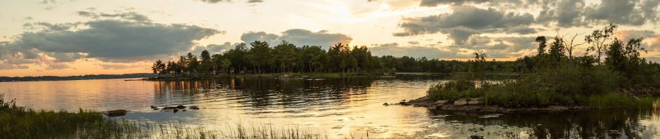
From Chikanishing Creek To Snug Harbour
Unlike that Lake Superior trip, this time, the northeast shore of a somewhat more gentle Georgian Bay (Champlain named it “La Mer Douce” on his 1618 map) will provide the stunning seascape and island scenery.

Ken, Rick, and I will put in on the banks of Chikanishing Creek in Killarney Provincial Park. The starting point is about ten kilometers east of the town of Killarney and eliminates some open and exposed paddling in favour of a more gentle start.
- Rick has done several trips on Lake Superior and Georgian Bay;
- Ken is a lifelong sailor with lots of Caribbean big water experience.
- And then there’s me with my summers spent canoeing the interior lakes and rivers of the Canadian Shield! I figure I’m the kayaking rookie and in pretty good hands!
The weather forecast for August 22 – August 30 looks excellent – all except for some rain on the very first day/ Maybe it will be over by the time we set off!

During that timeframe, the plan is to paddle the 150 kilometers down to Snug Harbour at the entrance to Parry Sound. On the way, we’ll make our way east on the G’Bay side of Philip Edward Island and along the mouth of the French River, the very first river to make the list of Canadian Heritage Rivers, thanks to its association with the voyageurs and the fur trade from the early 1600s to the 1820s.
Then we cruise by the mouth of the Key River and the entrance to Byng Inlet – lots more history, this time of the lumber industry and railroads. Nearing Point Au Baril, as the weekend approaches, we may see some boat traffic because of the increasing number of cottages the further south we head.
——————-
Exit Point: Dillon or Snug Harbour?

Both Dillon and Snug Harbour are popular start and endpoints for Georgian Bay kayak trips. While both are close to Franklin Island, Snug Harbour is closer to the many excellent campsites at the island’s south end.
Before getting shuttled up to the start of the trip at Chikanishing, we will park our vehicles at Snug Harbour.

The Gilly’s Marina parking lot makes for a convenient – and safe – spot. They charge $7.50 a day for the service. The Dillon Cove Marina up at the north end of Franklin charges a similar fee.

West Fox’s gravel beach on the W side of the island
It will be non-stop photo ops as we make our way through some incredible “eye candy”! Most of the shots will undoubtedly be taken from land, but I plan to have my Fuji x20 on board inside a waterproof Pelican case as we paddle so I can get the occasional shot from the water.

approaching the Bustard Rock lighthouse

Bell Cell Phone Coverage
We have set aside nine days to do the 150-kilometer journey. If we don’t need the extra wind days, then we’ll get it done in a day or two less!
Amazingly, this beautiful slice of nature – wild, even if not completely devoid of signs of “civilization” – is within a three-hour drive from Toronto and the G.T.A., North America’s fifth-largest bit of urban sprawl! Except for the first day or two, we’ll be close enough to Highway 69 to be in cell phone coverage range for the entire trip! Last year phone calls were even possible in the Philip Edward Island stretch at the top end of the route.
Testing Our New Garmin inReach Explorer +

inReach Explorer+

iPhone & SPOT Connect
I am taking along our new Garmin inReach Explorer+ GPS tracker and two-way communication device to get to know how it works. It replaces our previous GPS tracker and SOS transmitter, the Spot Connect pictured on the right. We decided to make the switch to the Garmin inReach because it not only sends out messages but can also receive them. The Spot can only send brief 45-character messages; it also requires a smartphone to be functional, while the inReach can function independently.
We also switched because of an incident where the Spot initiated an SOS call without our input! It was a total energy-sapping fiasco that, like it or not, came to define the trip. You can read all about it by scrolling to the tail end of this post dealing with Day Two of a recent canoe trip –
Canoeing The Little Missinaibi River: Day 2 – From Ramhill Lake To Below Rawhide Lake
Both devices provide real-time tracking information – the GPS location – which is posted at the respective company-maintained website. Below is a screenshot of the page as it looks right now – i.e. empty!

On Tuesday, August 22, our kayaks will be in the water! Until then – some last-minute packing to do. Cramming everything into the kayak’s two main hatches in little waterproof bags will be a novelty to this canoe tripper used to organize everything in two large 110-liter canoe packs and two large duffle bags!

a protected channel near Hincks Island in Georgian Bay – a shot from last summer
Day-By-Day Reports
Check out the following posts for maps, info, and pix of our paddle down the coast.
Days 1 & 2 Chikanishing Creek To Solomons I. to NE of Point Grondine
Days 3 & 4 Point Grondine To The Bustards’ Tanvat I. To S of Byng Inlet
Days 5 & 6 S of Byng Inlet To Hangdog I. Channel To Garland I. (Minks)
Days 7 & 8 Garland Island to Franklin Island To Snug Harbour
The weather – i.e. the wind and the waves – determined our route – and it will determine yours! Most days I wore the Farmer John neoprene wet suit that I had picked up at Mountain Equipment Co-Op in 1995 for that Lake Superior kayak trip. I’m glad I hadn’t given it away in the intervening twenty years!

Looking forward to seeing those photos…
Shirley Rose Cockburn
CockburnStudio
And having looked at your recent paintings, I can imagine what you’d do with Georgian Bay! Your painting #733 – Northern Lights – a tent spot with that as the view would make the trip! Wow!
From the book In The Footsteps of the Group of Seven by the Sue and Jim Waddington, I learned that some of the Group spent time on the Bay and were inspired by the views. They brought their paints and easels. I am going to bring my tripod and massive dslr and hope for the best – i.e. #733!
Ramblin’ Boy! Georgian Bay is beautiful so you’ll have your fill of ‘GB Eye Candy”!! But keep an eye out for the ellusive “Georgian Bay Turtles”….they can be especially pesky…should you “happen upon” one. Garry/Bolton
Garry, thanks for the “heads up”! First I read about the massasauga rattlesnake in the French River delta area and on the various off-shore islands – and now you add “pesky” turtles to the list of wildlife! I should be so lucky as to say “hello” to either but will have my camera ready!
In June for our trip through the Chapleau Crown Game Preserve – world-renowned for its bear population! – I bought two cans of bear spray…one for me and one for my brother. I was fully expecting some company! We did see two bears over the nine days but in each case they took off after seeing us. We’d have better luck if we hung around Chapleau’s garbage dump!
Ramblin’ Boy…with regards a bear…don’t forget, you don’t have to out run the bear…just out run your brother!!
You do know what a GB Turtle is? Garry
Good advice, Garry! That must be why they recommend you enter the woods in groups of four or more! Re: the pesky turltles! Clearly i missed that one completely! Thanks for sending the explanation via private email so I don’t look like a total idiot!
A poijnt of clarification – the “turtles” Garry is referring to is…well, here is how he put it in that email …
Kas Stone in her guide-book to the Bay does mention the ever-changing nature of passages between islands and narrow channels that seem to disappear from one year to the next depending on water levels. I’ll have to be extra-careful with my rental kayak from White Squall!
Garry, thanks for explaining the metaphor!
Just so you don’t feel so bad but…I first thought they had 4 legs as well…I learned through a friend who purchased a cottage years ago “on the Bay” and was warned by his neighbours…before he found out tha hard way. He strung me along for a while.
Nice of you to come clean within the hour!
Suzanne, nice to hear my posts are useful! If nothing else, they prove that while you can take the teacher out of the clasroom (after 35 years!), you can’t take the classroom out of the teacher!
Re: my Garmin GPS unit. While my brother uses his on every trip, i have stopped using my Garmin Oregon unit. Our new Garmin Exlpoer+ does come along but not for navigation purposes. We take it because it created a track of our route so that the folks at home can see where we are and follow along. It also allows for two-way communication and has a nice weather forecast function. The map on the unit is very small and is certainly not like looking into an iPhone screen.
I would say – if you do not have a GPS unit yet, don’t bother getting one. Instead, make use of your iPhone. Since you already have figured out how to download Google maps, you know it works. However, there are better maps for Georgian Bay paddlers available for download and they are free.
You can get the maps via a free ios app called Topo Maps Canada by David Crawshay. Here is the link –
https://itunes.apple.com/ca/app/topo-maps-canada/id392857820
After you have installed it on your iPhone, the next step is to start up the app and download the 1:50,000 Natural Resources Canada topographical maps which cover the area you are interested in. These map sheets cover G’ Bay from Chikanishing to Parry Sound::
041 I 03 Lake Panache
041 H 14 Collins Inlet
041 H 15 Key Harbour
041 H 10 Naiscoot River
041 H 09 Pointe au Baril Station
041 H 08 Parry Sound
While you are at it you might also print paper copies of the parts of the above map sheets that you need. Much better to make use of hard copy maps most of the time and just use the iPhone occasionally to confirm where you are.
There is also an Unlostify Map for the Killarney coastline and for the French River delta area that you can get free digital copies of – and which work with your iPhone’s GPS. The Unlostify maps also come in a plastic version – $20. a copy – which should survive years of use and abuse!
The iPhone is even useful in some spots on the Bay to make phone calls home!
I did get a waterproof Pelican case for my iPhone though I am sure a ziplock bag will also do the trick!
Check out the Topo Canada Maps app and let me know how it goes! And all the best in putting it all to work when you are out on the Bay when paddling season begins! My bro and I are planning a trip down the length of the French river from lake Nipissing – just two months to go!