Previous Post: Day 4 – From West to East – Up, Down and Across the FR Delta
Day 5 – To Bass Creek and F. R. P. P.’s East Side
- distance: 19.4 km (includes a side trip to Bass Lake and some hill scrambling)
- time: 8:30 a.m.; finish 2:15 p.m.
- portages/rapids: 1 / 1
- P1 – 105m – side trip up to Bass Lake and then back again later
- L/O – high water paddle/lining job or low water lift-over
- weather: sunny and hot; some wind;
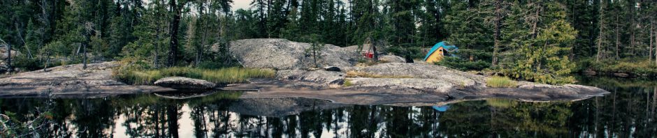
- campsite: CS 712 (old #913) in the delta; multiple 2 or 4-person tents, 1 nicely sheltered spot
——————–
Table of Contents
- Checking Out The Bass Creek Portages
- The Used-To-Be Tramway and Boardwalk
- Bass Creek Scenic Lookout
- Bass Creek Route – The Easiest Route to Georgian Bay
- The Piece of Dock at Dock Island
- Looking For a Campsite at the Park’s East End
- Update: The Impact of the 2018 Henvey First Nation Wildfire On The Lower Pickerel River Campsites
——————–
Checking Out The Bass Creek Portages
By 8:35, we were on the water for another day of paddling through the maze of rocks and islands along the Georgian Bay coast. We had as our target the east end of French River Provincial Park and maybe – if we could find a good one – a campsite on one of the Outer Fox Islands. If not, there were some designated campsites nearby that we could check out.
But first – a reconnaissance mission! We wanted to see the Bass Creek portages and the route up to Bass Lake. Once there had been a tramway; then, there was a boardwalk. We wanted to see what was there now!

NB. All maps and images enlarge with a tap or a click or two.

looking west towards our last night’s G’Bay campsite
On the way, we did stop on Macoun Rock to stretch our legs and fuel up on Gatorade and a Clif Bar. It was just after nine, and we were already feeling the heat! To the north of us was Hershel Island, whose east side we paddled along a few minutes later.

Break time on Macoun Rock just S of Hershel I.

canoe beached at Macoun Rock
By 10:00, we were past Flat Island and nearing Bass Creek. After a 400-meter paddle up the Creek from its mouth, we came to the floating dock. It is the take-out for the 115-meter portage. (See the image below.) Stashing our bags in the bush at the start of the portage trail, we carried the canoe and paddles – and camera bag – to the other end. We’d be coming back in about an hour.

the dock and portage take-out spot on Bass Creek
As we paddled away from the put-in at the south end of a narrow lake, we looked back and noted the portage signs. They were just two of perhaps eight or nine signs indicating a portage we would see on our visit! Some – like the ones in the photo above – look like official park signs; others were probably put there by the landowners at the other end who are tired of paddlers tramping across their property looking for a boardwalk that no longer exists!
——————–
The Used-To-Be Tramway and Boardwalk
Kas Stone’s Paddling And Hiking the Georgian Bay Coast provides some history to make sense of what was once there and what is there now. Of the original tramway, complete with rail tracks and a flatbed car, she notes this –
The line was built in 1912 by the Pine Lake Lumber Company, which had just purchased the abandoned sawmills at French River Village and wanted to move them upstream to a new location on the Pickerel River. Subsequently the tramway was maintained by the provincial Department of Lands and Forests for transporting firefighting equipment back and forth and also used by local cottagers and fishing camps to move their boats, building materials, and even their guests between the French River and Georgian Bay. Indeed, Rainbow Camp was built in the early 1920’s at the top end of the tramway to allow its guests easy access to fishing in both the bay and the river. (Stone, 71)
Eventually (no date was given), the tramway was taken apart, and the rails were removed. It was replaced by a 240-meter-long boardwalk. Stone’s book was published in 2008. At that time, the boardwalk was still in use. She writes –
Although the land around Rainbow Camp is privately owned, the tramway [i.e. the boardwalk!] itself is available for anyone to use.

1990’s Federal Govt topo with the boardwalk portage indicated – NB no longer in use! Use the signed portages instead.
However, some time since 2008, the boardwalk has been dismantled after falling into disrepair. The apparent reason: the owner of the land it crossed was afraid of getting sued by someone who hurt themselves using it. How that fits with Stone’s above comment, I am not sure! Googling “Rainbow Camp Bass Creek” turns up no information! There is a Rainbow Camp on the French River, but it is near Noelville on the North Channel on the east side of Highway 69. The Bass Creek property has likely been turned into a private cottage.
I was surprised to see the boardwalk recommended as part of a route in Kevin Callan’s recent (May 3, 2017) article on the Explore website – 6 Northeastern Ontario Paddle Trips to Get Stoked On. In the section on The French River, he gives canoe trippers some outdated-by-a-decade information. Of the Bass Creek Tramway, he writes –
The return trip to the access at Hartley Bay Marina is by way of the Eastern Outlet and the Bass Creek Tramway. This 240-metre boardwalk, originally constructed of rails mounted on large timbers, was first established as a way for the lumber companies to move their mills off Georgian Bay and move them more inland.
There is no boardwalk anymore. There is one easy portage at the south end and a lift-over at the north end!

the portage markers on the east side of the Bass Creek Portage
After our carry from the dock, we did the short paddle up the narrow lake to the second “portage.” The official park map has it marked as “10 meters”. We found a shallow and narrow channel – and maybe the beginnings of a beaver dam! – that we pulled our way up. We may have stepped out of the canoe to move it along. According to locals, the higher water levels in 2017 – two feet higher – explain the missing mini-portage!


The 5-meter lift-over into Bass Creek – we paddled up and back down.
We were now in Bass Creek again, looking at a collection of signs pointing to the five-meter “lift-over” we had just negotiated. Whoever put them there wants you to head for the narrow channel we had just come up rather than looking for a no-longer operational boardwalk! The broken-line trail indicated on that 1990’s vintage Natural Resources Canada topo map above does not help matters! The image below shows the remains of some of that boardwalk in front of the cottage.

private property on the east side of Bass Creek
——————–
Bass Creek Scenic Lookout
We paddled south on Bass Creek past the property. We should have stepped ashore and checked out the remains of the boardwalk and snapped some photos, but we did not want to annoy the owners. In retrospect, we realize they probably weren’t there anyway! We paddled down the Creek, soon beached the canoe, and scampered up that hilltop on the west side of the Creek you see in the photo below.

Max on top of Viewpoint Rock on Bass Creek – stupendous spot!


looking north up Bass Creek from the hilltop

Bass Creek – looking north and east

a grand view of Bass Creek – looking south

looking northeast up Bass Creek

a view from the top of Bass Creek

looking down Bass Creek
We spent a half-hour enjoying the views from our hilltop viewpoint and expressed the “wow” concept several times in different ways! This was an unexpected bonus thrown in on top of what was already a fantastic scenic paddling trip. I’m glad we took the time to get out of the canoe and scamper up the rock. Sometimes my brother and I can get too focused on getting those kilometers in!

paddling back to the portage from our visit to upper Bass Creek
——————–
Bass Creek – the #1 Easiest Way to Georgian Bay from Hartley or Ox Bay
Then it was back the way we came – down the narrow lake through the reedy part at the north end, over the portage trail and back to our canoe packs and duffels we had left behind – and finally, back down Bass Creek to the Georgian Bay coast.
If there is an “easiest” route from Hartley Bay to the Georgian Bay coast, one involving the least portaging, this route down Bass Lake and Bass Creek must be it. Easy for canoers, it would not be that bad for kayakers either. As a bonus, it leads you to Cantin Point and the shortest crossing over to the Bustard Islands.
——————–
The Piece of Dock At Dock Island
 As we headed east, we paddled along the south side of Dock Island and wondered about the dock pictured in the image below and if it was the reason for the island’s name.
We looked south and saw the buildings of the Georgian Bay Fishing Camp, a full-service lodge that looks a lot grander than its name!
Update: A reader – see his comment below – provided the explanation for the dock. He writes:
The old dock in your one photo actually drifted over from the fishing camp. The camp has been unused since 2016. Lack of maintenace plus higher water levels allowed it to be set adrift.

Dock on the south shore of Dock Island across from Georgian Bay Fishing Camp
——————–
Looking For a Campsite
We soon stopped for lunch in Beacon Rock Bay. Not far away were the Outer Fox Islands. In the image below, Max is examining the map for the best way of getting over there for a tour of the small archipelago. We thought we might find a possible campsite on one of the islands if it had some tree shelter and a flat spot for a four-person tent. If not, as the map below shows, there were several designated French River Provincial Park campsites that we could check out.
![]()
Our visit to the Outer Foxes provided yet more great views and scenic small channel paddling – but, after checking out a few likely spots, we did not find our campsite for the night. We decided to aim for CS 913 (new #712), given its location and proximity to Genessee Bay since we’d be paddling up the Pickerel River the next day.

Note: campsite #s are the old ones. See this FRPP CS # list for the new #s issued mid-2021.

CS 712 (old #913) just above Dead IslandChannel
The site proved to be a good choice. It had a sheltered and flat spot for the tent, with the earth floor being a bonus. A dozen tents could be pitched nearby, depending on how fussy you were! The rock outcrop running along the shore up the bay also meant we could explore later.

looking up the bay to where a couple of other campsites are located

CS712 seen from CS 711 (old #914)

We did walk up the shore of the bay to the next campsite – CS 711. It was not as nice a site, and at first, I could not even see its marker. The blue sign finally caught my eye as I looked over at the fallen tree trunks in the photo below. The wind or a beaver – or maybe both – had done the job!

CS 914 marker
There is a boaters’ channel that runs along the coast. As we sat there and looked out into Georgian Bay, we saw two boats make their way between Dead Island and the point we were camping on. It was a Sunday afternoon, and we thought it might be busier, especially given our proximity to Key Harbour. However, since it was late September, it was much more tranquil than during prime summer. As for fellow paddlers, we had only seen one party of four kayaks and four canoes during our first five days out. We basically had the park to ourselves!

the view of the boaters’ passage from our CS 712

one of the fire rings at CS712
At the end of the day, we packed up the food bag and took it for a 70-meter walk down the shore. It has been a few years since we did the nightly “dangling the food bag from the  branch of a tall enough tree” ritual. Partly it was because the terrain we were paddling in often did not have the trees required to hoist our forty-pound bag up. These days – no more bear piñata! Now, we slip the food bag – one of our two rugged nylon Hooligan Canoe Packs – inside a large garbage bag, put a log over it, and walk back to the tent. Never an issue since 2012!

On tap for the next day was our trip back towards Hartley Bay and our vehicle. While we could easily have done the entire distance in one day, we had decided to stop for the day just a bit short of the endpoint. Given the number of campsites in Pickerel Bay, we were aiming for that.

Note: CS #s are the pre-2021 ones. See this FRPP list for the revised numbers.

——————–
Update: the Impact of The 2018 Henvey Inlet Fire.

Henvey Inlet Fire 2018 – and east end of French River Provincial Park
The 2018 wildfire was caused by construction crews working on the Henvey First Nation windmill project. It spread as far west as the Fox Creek corridor and impacted the lower Pickerel River. The campsites on the Pickerel – including 913/712 we made use of – were closed in July 2018 as a result.
It should still be possible to paddle up or down the half-day stretch of the Pickerel from G’Bay to Pickerel Bay, but from a reader’s comment, it seems that CS913/712 is still closed. She wrote (August 2022) –
We went to site 913 / 712 last week and it is closed- burned in a forest fire. We ended up on the same shore, closer to the point, as we couldn’t battle more wind that day to get to another official campsite. The spot we ended up at was nice, protected from wind, sleeping on flat granite. Posting this to help others plan.

The 2021 edition of the official Park map should indicate which campsites are still closed due to the 2018 fire. If you stop off at the Visitors’ Center to get your backcountry permits and a copy of the map, you might also ask the park staff at the info desk about closed campsites.
Excellent write-up! Yes, Wow describes the area perfectly. We spend some time up there every year putting around and camping/scubadiving/enjoying the emptiness.
The old dock in your one photo actually drifted over from the fishing camp.The camp has been unused since 2016.Lack of maintenace plus higher water levels allowed it to be set adrift.
May you get back up there soon.
Bill, thanks for the explanation for how that dock got there! I’ll add your info to the post. We’ll hopefully be back up there this fall! It makes for a nice week-long escape from the 416!
Your explanation of how to get through Bass Creek is super helpful, because I am planning to go through there myself in May… and as you say, Callan in 2017 was not up to date, and neither is Tom Harting’s book.
By the way, my Polish dad also spent all of WWII in a POW camp (I never was able to beat him in chess after that!), and I similarly learned to appreciate nature and love the outdoors from him (it’s a Polish thing, maybe), so that at 68 I too am still happily at it… (kayaking in Ammassalik for example was… nice!).
Send me a side email if you like, I’d welcome it.
The Bass Creek bypass is very easy to do – just the one short portage and a possible lining up the swifts at the north end. Callan’s 2017 account is a decade out of date; Harting’s book came out in 1995 so it was correct when it was published. Things change!
We lived in Rouyn Noranda and my father worked for 35 years in the mine there, at first underground in the timber gang and then on the surface in the machine shop after he caught bronchitis working down below. I still remember the hikes he took my brother and me on when I was about ten years old – three kilometers through the bush to a small lake – Rose Bear we called it – north of the edge of town where we lived in a company house. The bush was our playground when we were kids; we spent our entire summers building forts, cutting trails … to me, it has always been a place to recharge and have fun, a return to simpler times. Like you, I’m 68 and planning the next canoe trip.
BTW the NE corner of Georgian Bay has drawn my brother and me back a few times since our original visit when we paddled around Philip Edward Island back in 2016. It makes for a very accessible canoe trip and does not involve park fees and campsite reservations…just the way we like it. There is still a feel of wilderness to it.
Enjoy your trip on the G’ Bay coast. Good luck with the weather! May it be calm enough for you to paddle over to the Bustards!
The galactic center is visible in the south in summer, and the north shore of Georgian Bay is one of the few places around where there is little light pollution looking south, and where the horizon is also visible, and not obscured by trees… the rocky coast reflects weak light and makes a great foreground too… what a marvellous place, even at night! Maybe we’ll meet up out there then some day.
Thanks for the tip about the NE corner… (I have kayaked with Black Feather from Killarney to Key River, so I went past there.)
My dad also once took me and my two sisters on a hike through the bush using his WW11 compass to a deserted lake where we found a wrecked rowboat with a hole that we were able to plug up with a shirt button wrapped in a rag… this was north of St Jerome, in Quebec.
Thanks so much for posting these travelogues! They’re fantastic to get the ‘feel’ of the French River, and set our plans (we followed many of yours). We went to site 913 / 712 last week and it is closed- burned in a forest fire. We ended up on the same shore, closer to the point, as we couldn’t battle more wind that day to get to another official campsite. The spot we ended up at was nice, protected from wind, sleeping on flat granite. Posting this to help others plan.
Jaana, thanks for giving me a nudge to update my post! It was written before the 2018 fire that impacted the Pickerel River corridor. I knew that the campsites on the lower Pickerel were closed. Did you paddle up or down the Pickerel and see how the flora is recovering four years later? I will never tire of paddling the French River delta area – up, down, across – it is all incredibly scenic. Nice to hear my posts helped you in your route planning.