Table of Contents:
- The Day’s Basic Data and Map
- Heading To The Voyageur Channel
- Checking Out Campsite #834 (old #818)
- La Prairie – Voyageurs’ Stopping Place
- Up Black Bay To The Top of the Voyageur Channel
- Lunch At The Top of The Voyageur Channel
- We Meet Two Paddlers Whose Trip Had Started In Alberta
- Paul Kane and La Petite Faucille
- Down La Dalle And East Along The Cross Channel To Devil’s Door Rapids
- The Devil’s Door Portage
- Down The Cross Channel’s East Section
- Our Campsite On Georgian Bay
- Day 5 Preview with Map
Previous Post: Day 3 – Bustard Islands Camp To Eagle Nest Point
Canoeing Georgian Bay’s French River Delta:: Day 3 -The Bustards To Eagle Nest Point
—————
The Day’s Basic Data and Map
- distance: 18.2 km
- time: 8:35 a.m.; finish 4:15 p.m.
- portages/rapids: 3 + a few lift-overs and a bit of lining
- L/O – 30 m – lifted and tracked
- P1 – 120m
- P2 – 20m Old Voyageur Channel
- L/O – cross-channel – lift and track sections
- P3 – Devil’s Door Rapids – 30 m up the hill, 30 m down the hill in two minutes!
- L/O – 10m – perhaps a portage in low water
- L/O – 5m beaver dam type structure
- weather: sunny and hot; some wind;
- campsite: CS 689 (old #723) on the delta; multiple 2 or 4-person tents, 1 nicely sheltered spot

Day 4 – From Eagle Nest Point To CS 723 East of The Fingerboards Islands
—————
Heading To The Voyageur Channel
Another clear sky day was on tap as we went through the usual routine after crawling out of our sleeping bags and stuffing them back into their compression sacks. Intent on not missing the rising sun, I snapped a shot of the islands of Green Island Bay to the northwest and another of White Rock some 400 meters offshore from Eagle Nest Point.


looking south from Eagle Nest Point To White Rock in Georgian Bay
We were on the water before 9 and headed north. After a day of coastal paddling, we had something else in mind for this day. We were going to check out the French River’s two so-called Voyageur Channels, paddling up one and then coming down the other.
Visions of Indigenous traders and guides, Canadien voyageurs and North West Company canoes came to mind as we made our way. No wonder when the newly established Canadian Heritage Rivers program began in 1986, the French River was the first river chosen!
—————
Checking Out Campsite #834 (old #818)

CS 834 (old #818) in Batt Bay/Green Island Bay
On our way, we stopped to check out CS 834, a site on the north end of an island a kilometer north of the one at Eagle Nest Point. It is one of seven designated sites in the Green Island Bay/Batt Bay area.

Eagle Nest Point and Surrounding Area
While it is a good site, it does not have the superb location of the one we stopped at. Note that the CS numbers on the map above are the old, pre-2021 ones.)

The CS # is now 834!

CS 834 tent spot on Batt Bay island – see Day 3 post for a map of the bay and campsites
—————
La Prairie – Voyageurs’ Stopping Place
Update (2020): At the top of Batt Bay and the west end of the Voyageur Channel is a site identified by Toni Harting as a favourite stopping place of the fur trade brigades after their descent of the French River from Lake Nipissing. They usually did the French River in one or two days and then met at this spot – called La Prairie – before continuing on to Georgian Bay and the journey along the Lake Huron coast to Sault Ste. Marie and beyond.

I only learned about La Prairie a couple of years after this trip by reading Toni Harting’s book. A recent post from last year’s trip down the French River from Lake Nipissing – click here – has the details.
But more than that, it told me that my understanding that the voyageurs used the Voyageur Channel was incorrect! I had assumed the name given to this channel corresponded to the reality of their route choice. Not so! Harting writes:
On maps, the Voyageur Channel looks tempting as a possible canoe route as it is shorter than the others. However, this channel is very hard to access at low water levels, especially using large canoes. It seems, therefore, somewhat out of place to call this the Voyageur Channel since it is unlikely that fur-trade freight canoes would have used this channel on a regular basis given the great difficluties that would have been encountered. [Toni Harting, 32]
—————
Up Black Bay To The Top of the Voyageur Channel
Paddling east on the Voyageur Channel we turned north into Black Bay. We planned to follow it up to the top and then take the channel which runs parallel to it on the east – the Old Voyageur Channel – back down to Balis Point before turning east on the Cross-Channel all the way to Devil’s Door Rapids.

Even though we had the official Park Map, we had no idea of any complications along the way; the Park map does not show any rapids or portages.
The annotated map below shows what we found out over the next few hours!

The canoes (10 meters in length and about 1.5 meters wide) were the freighters of the fur trade, carrying the trade goods from Montreal to the far end of Lake Superior and then returning with the furs. The portaging necessary on the Voyageur Channel would undoubtedly have been more time-consuming and awkward than what was required on either
- the Main Outlet’s Dalles Rapids or
- the channel now called Old Voyageur Channel.

10:45 a.m.- at the top of a section
On our way up the Voyageur Channel, we first dealt with Washerwoman Rapids. An awkward tracking job – lousy footing! – it got done in fifteen minutes, and then it was on to the short portage at the channel’s top.
—————
Lunch At The Top of Voyageur Channel
Twenty minutes later, we rounded the corner for the Old Voyageur Channel, where we stopped for lunch. Then we started to make our way down. the channel is certainly narrower than the Black Bay we had come up in the morning. We were struck yet again by what a sustained scenic marvel this trip was!
Having done canoe trips all over the boreal forest area of the Canadian Shield, we figure the French River area is not only one of the most accessible but also has the most day-after-day beautiful scenery. A bonus is that very little portaging is needed as you paddle around. The campsites are mostly terrific. This is where you bring a newbie to introduce them to the pleasures of canoe tripping – but in June or September when it is less busy than it gets in the prime summer months.

Hopkins. Canoes manned by voyageurs passing a waterfall. 1869.
—————
We Meet Two Paddlers Whose Trip Had Started In Alberta
Just before we came to the one set of rapids on the Old Voyageur Channel, we approached a canoe coming upriver. I was initially struck by the paddling technique of the couple in the canoe. They were alternating sides every four strokes. I remember thinking they were total novices out for a day paddle. Their response to my first question – “Where are you guys coming from?” – was yet another reminder of the danger of making rash judgments! Their response – “We started off in Alberta in May.” Whoa!
We had paddled into Cas and Michael Wild, a newlywed couple from Scotland, on the last leg of their epic canoe trip, starting at Rocky Mountain House in mid-May. It was now late September, and they were on the home stretch to Montreal! We chatted for a while and then headed in opposite directions, they up to Lake Nipissing and the Mattawa River. You can check out their website for more on their epic canoe trip at The Doctors Wild WordPress website.

Chatting with the Doctors Wild on the Old Voyageur Channel
—————
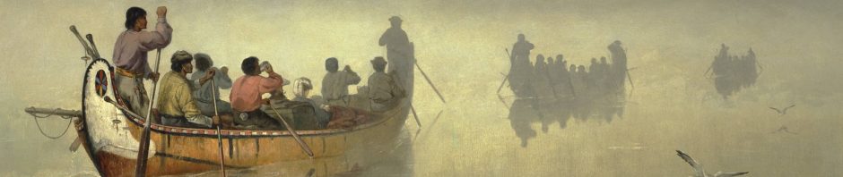
Paul Kane and La Petite Faucille
Up next – that set of rapids around the corner! To the voyageurs, it was known as Petite Faucille, an abrupt one-meter drop in the river. Given the length and depth of their canoes, a 20-meter portage was the norm.
Until recently, it was thought that Paul Kane’s painting “French River Rapids” depicted this very spot, turning the sketch he did at the scene in May of 1846 into a painting some years after returning to Toronto.

Paul Kane. French River Rapids. 1850’s
As I sat there on the rock, I looked for the rock face on the other side of the river. It wasn’t there! The assumption over the years has been that Kane took a bit of artistic license to heighten the scene’s drama at Petite Faucille.

La Petitie Faucille – Old Voyageur Channel rapids
I have since learned that there is a better explanation, one that was not found until 2006, when Ken Lister set off with his canoe, Kane’s journal, and a collection of Kane’s sketches. It turns out that Kane never came down the French River into Georgian Bay so he would not have had a drawing of any of the rapids! [See here for a map of his route to Lake Superior.]
In an impressive piece of detective work, Lister found the location of the mislabeled “French River Rapids” painting. It is referred to in Kane’s journal as “the French Portage.” Lister found it in northwestern Ontario! As Lister writes –
The French Portage—part of the Kaministiquia River–Dog Lake fur trade route between Lake Superior and Rainy Lake—was known to fur-traders as the Grand Portage des Français and was used to bypass a long section of the French River that was shallow and winding.
See Lister’s account of his quest and how it all fell into place.

Petite Faucille on the Old Voyageur Channel
—————
Down La Dalle And East On the Cross Channel To Devil’s Door Rapids
We continued down the narrow channel. Some swifts (known as La Dalle) as you approach Balis Point will speed things up a bit for about three hundred meters.
The cross-channel from Balis Point to Devil’s Door Rapids is a leisurely paddle with only one set of rapids to deal with. We lined our canoe past them and continued on to Devil’s Door, indeed a dramatic name. We got there just as some kayakers were cautiously going over the ledge of the rapids – though “Falls” is a better word to describe the 1.5-meter plunge. They went over, disappeared from sight for a moment, and reappeared as their kayak came close to smashing into the left-side rock wall. We needed to take a closer look before we did anything!

kayakers taking the plunge down Devil’s Door Rapids
The Friends Park map does not show the portage around the rapids. [Why not?] We headed to a small bay on river left, beached the canoe, and scrambled up the rock to the top for fantastic neighbourhood views.
- A look down at the rapids,
- a look up the channel to where we had come from –
and then decision time. We were going to portage.

a view from above the Devil’s Door Rapids

Max checking out Devil’s Door Rapids

looking up the West Cross Channel from above Devil’s Door Rapids/Falls
—————
The Devil’s Door Portage
But where to portage? Our scramble up to the top of the cliff told us that this was not the way.
 Once back down to the canoe, the answer became obvious. In our rush to get to that hilltop view of Devil’s Door, we had not noticed the 30-meter “path” littered with boulders going up to a ridge. We walked up to the top and looked down another 30 meters to the shoreline and a tranquil bit of water below the rapids. This was going to be much easier than expected!

looking back at our canoe from the top of the Devil’s Door portage trail
The bags – the two Hooligan Packs and the two duffels – and the four paddles went over first. Then I went back for the canoe. Max decided this portage would be captured in video and stood on the top of the path as I carried it up and over. Since the front of the canoe was at the rear, the first thing I had to do once the canoe was up on my shoulders was whirl the thing around. As for the carry – total time? Two minutes! No big deal!
However, if you are looking for a bit more drama to go along with the name of the rapids, check out the account of the portage in this YouTube video – Devil’s Door Rapids – uploaded by a solo paddler earlier this year. The Devil’s Door Rapids section begins at 10:00 and lasts four minutes. It gives viewers a false impression and seriously over-hypes the 60-meter carry.
—————
Down The Cross Channel’s East Section

from Devil’s Door Rapids to CS 804 (old #723) E of the Fingerboards
Crossing Bad River Channel, we headed for the continuation of the cross-channel and easier and totally enjoyable paddling down a narrow channel past lots of vertical rock faces. Only two obstacles along the way, both of which we dealt with in a few minutes.
—————
Our Campsite On Georgian Bay
We were heading back to the coast and CS 804 (old # 723) on an island accessed from the interior side. A 50-meter walk, and you are on the Georgian Bay side. The collections of rocks on various flat surfaces are evidence of yet more tenting choices when tent pegs do not work.

CS 804 – home for the night with a Georgian Bay view
The tent spot we chose was a flat spot nicely tucked inside a stand of cedars and pines with enough earth to use those tent pegs. After we set up a line to hang our down sleeping bags on for a bit of wind and sun, we set up the canoe as a tabletop and got supper ready. That done, we wandered over to the Bay side where, later that evening, we returned for some sunset views of the big water. We also got to see some old friends again – but from a different angle!

About four kilometers away from CS 804 are the Bustard Rocks lighthouses. We had approached them from the east on Day 3, and now we were looking at them from the north!

A few minutes later, with my back to the setting sun, I framed a photo on the other side of the island campsite. A different look for sure!

—————
Day 5 Preview
Day 4 had been an excellent paddling day; Day 5 would be a day we played tourist – paddling up Bass Creek to see what the portages were like – before heading back to the G’Bay coastline and a possible campsite in the Outer Fox Islands. None were indicated on the official map, but we hoped to find something suitable.

Next Post: Day 5 – from CS 804 to CS 712 With A Side Trip Up Bass Creek
Canoeing Georgian Bay’s French River Delta: Day 5 – To Bass Creek and the Park’s East Side
Devil’s Door can go from being completely flatwater to ragging 2 foot drop -at least. If the river is high and the Bay is low it is impassable for everyone. The Jamison can be just as bad. The Crooked has claimed a few lives and so has the Jamison (and almost took out the Assistant Park Superintendent who has lived up there his whole life)- what a story that is and how he and his coworker survived. I’m glad you enjoyed your paddle in what I call home. My family has been cottaging there since 1916.
1916! Now that is roots!
I have heard of people paddling up the Devil’s Door. I was initially skeptical but have heard it more than once. As for the other rapids in the Bad River Channel, we hope to go up and down all of them before our paddling days are over! We have already learned that the rapids you go down one year can be quite different the next, thanks to different water levels.
The Delta area is where I will be doing my last little canoe trips – it is close to Toronto and is 11/10 for scenic views and campsite possibilities – and very few portages needed, all of which are easy and short. What’s not to like!