We were looking for a shorter Ontario river system this year, something
doable in a week or so
with uncomplicated logistics while
still having the feel of wilderness.
We found it in the Steel River system in the Lake Superior High Country to the north of Terrace Bay!
Actually, what we found first was Rob Haslam’s post “Steel River Maps” in the Ontario Trip Reports section of the Canadian Canoe Routes forum. See below in the Mapping The Route section of the post. Rob provides the most up-to-date and detailed information on the river – everything from portages to campsite locations to rapids, swifts, and logjams.
—————————
Steel River Provincial Park Maps and Info
Rainbow Falls – one of the highlights of a trip down the Steel
Eventually flowing into the north shore of Lake Superior, the Steel River system is smack dab in the middle of the very scenic High Country between Marathon and Terrace Bay. We have driven past it a few times on Highway 17 up to and back from Wabakimi or Woodland Caribou. It makes up the core of Ontario’s Steel River Provincial Park, categorized as “non-operating” since it is not staffed by anyone and does not have maintained campsites or portage trails.
An email to Ontario Parks confirmed there are no fees to pay – whether you are an Ontario resident or a non-resident from another province or the US.
the 1200-kilometer “grande portage” from Toronto to the put-in at Santoy Lake
A quick visit to the Parks Ontario website turned up the following brief description –
This wishbone-shaped park consists of long, narrow lakes, rugged cliffs, ravines, swamps, ponds, oxbow lakes, and a 20-metre waterfall. Great blue herons nest on the islands of Cairngorm Lake.
Park Facilities and Activities: There are no visitor facilities. Backcountry camping and canoeing are recommended activities.
Location: Twenty-four kilometres east of Terrace Bay, off Highway 17, above Lake Superior’s north shore.
Even better, we could paddle away from our vehicle on Day One, paddle down the 170 kilometers of the river over six or seven days, and end up right back where we started. It sounded like the canoe trippers’ version of a Penrose Staircase! Escher would be interested!
————————-
Jacobson, Callan, and Harting On the Steel
More research revealed that the Steel river loop was a tripping favourite of Cliff Jacobson, who has done the loop at least eight times since his first in 1976. Two of his books are in the canoeing section of what is left of my hard copy library. His extensive paddling resumé made his recommendation worth something.
my bro Max at the Santoy Lake Put-in On Day One – calm waters at the start!!
Included was a map of the route with Santoy Lake as the put-in. Callan has also included the chapter on the Steel River in a more recent compilation titled Top 50 Canoe Routes of Ontario. [A mapless version can be found at the paddling.net website here.]
Sitting next to Callan’s book on the public library bookshelf was PaddleQuest, a compilation of various writers, each describing one of thirty-seven of Canada’s best canoe routes. Edited by Alister Thomas and published in 2000, the book provided more fuel to stoke our interest.
It has a chapter by the late Toni Harting, noted photographer and past editor of the Wilderness Canoe Association’s journal Nastawgan. Titled “The Steel River: A Remarkable Loop,” Harting’s chapter provides the following evaluation –
The Steel River offers a remarkable 170-kilometer adventure just north of Lake Superior, all in one loop, beginning and ending on Santoy Lake. In many respects, this is a superb wilderness river: remote, clear, lots of flatwater, and manageable whitewater, between 15 and 20 portages…A marvellous river indeed, but not a trip for novices without sufficient whitewater and portaging experience.
Yet another positive recommendation to clinch the deal! It was time to look more closely at all the maps available! [The archive.org website has a downloadable copy of Paddle Quest.]
As mentioned, Rob Haslam’s maps are the obvious starting point. They are based on the Garmin Topo Canada maps and have all portages, most campsite possibilities, and the locations of the four significant logjams on the lower Steel indicated. Haslam knows the river and has done the entire loop a dozen times over the past 25 years. We would find his information totally reliable and very helpful in dealing with the challenges of the river.
————-
1:50,000 Natural Resources Canada Topo Maps:
The topographical maps maintained by the Canadian Federal Government’s map department still provide the most accurate map information for canoe trippers. The one thng they lack is info on portages and campsites. They are available at no cost online if you want to print them – or the parts of them that are relevant to your trip. For the Steel River Loop, three 1:50,000 topos cover all your map needs.
Click on the map titles for my 4 Mb jpg formatted files of the maps or
2. access the Natural Resources Canada 042 folder (here) for the 20 Mb tif files.
————–
David Crawshay’s Topo Canada iOS App:
David Crawshay’s Topo Canada iOS App for iPhone lets you download all of the above to your iPhone. While leaving the iPhone on all day to use as your primary GPS device would eat up battery power like crazy, it is handy to quickly confirm that you are indeed where you think you are! Download the app here.
—————
ATLOGIS Canada Topo Maps for Android OS
There is an Android OS app from a German app developer similar to Crawshay’s Topo Canada iOS app. However, it costs $14. U.S. Given its usefulness, the one-time cost is a worthwhile investment that will save you time and aggravation. Click here to access the Google App Store page –
Note: The free version of the app may be enough for your purpose.
—————
Toporama Canada Online Map:
Toporama is NRC’s modern version of the archived topo sheets listed above. It is essentially a seamless map of the entire country and allows you to extract from and apply all sorts of additional information and features to the map.
——————-
Garmin Topo Canada Map
As well as paper copies of the Federal Govt. Topos, we each have a Garmin GPS unit – the Oregon 450 and the Etrex 20 – with the latest Garmin Topo Canada v 4maps on it. (It is listed at an incredible $181. CDN in early 2018. We paid $110. back in 2011.) While not as accurate as the NRC maps, they serve as backup and provide a ready answer in those situations where you can’t figure out exactly where you are! We also like the waypoint and tracking features and how the eTrex and Oregon archive each day’s progress.
——————-
inReach Explorer+
If I don’t already have a GPS unit, a better option might be a device like the Garmin inReach Explorer+, which serves as a two-way communication device and also has many of the features of a GPS unit. We were still using our Spot Connect on the Steel to provide the folks back home with GPS tracking and nightly brief email message. Since then, we have upgraded to the inReach.
If you just wanted the GPS function, then your smartphone with the Crawshay Topo Canada app would do the job, as long as you could keep the battery charged! The Steel River area is off the grid, so you won’t be able to use your phone to contact anyone!
————————-
Our Steel River GPX Track:
We have also uploaded the gpx file of our Steel River Loop waypoints (along with several points noted on Haslam’s maps). You can download the 66 kb .gpx (Garmin format) file as a 5 Kb zip file from my Dropbox folder here.
______________________________
A Slight Complication!
Needless to say, that nifty 2-D Penrose Staircase shown above cannot exist in reality! In their trip reports, all of the above paddlers are quick to point out the one thing I haven’t mentioned yet – the price to be paid to get to that starting square for the ride down. Known as the Diablo Portage, it is an 1100-meter carry from Santoy Lake (249 m asl ) to Diablo Lake (348 m asl) and involves a 100-meter gain in altitude. Another 10 meters of altitude gain from Diablo Lake to Cairngorm Lake via three more portages, and you are in the true headwaters of the Steel River system. Some work will be required!
a typical stretch of the upper part of the Diablo Portage “trail”
After canoeing waterways all over the world, guidebook author Cliff Jacobson says the portage between Santoy and Diabolo [sic] Lakes is tougher than any other he’s found, even in the remote reaches of Nunavut—yet this pristine paddling escape sits right off the Trans-Canada Highway. “At just under a mile—1,673 meters, to be exact—it would be doable in 20 minutes if it were relatively flat,” he says, but hauling a canoe and gear through piles of Mini Cooper-size boulders takes all day. The elevation gain is about 300 feet (with 100 feet stacked into the first 100 yards), so “progress is measured in meters, not miles, per hour.”
[Note: 1,673 meters is not “just under a mile” – at 1.04 miles, it is just over! And while it may have felt like just under a mile to Jacobson, the actual portage is “only” about .7 miles or 1100 meters.]
We repeated our canoe-tripping mantra – ” we’ll git ‘er dun” – a few times as we looked at the contour lines bunching up close to each other between Santoy Lake and Diablo Lake. We accepted it as the price of admission and embraced it as only those who don’t really know can!
Update: August 2018. A four-man Anishinaabe crew from nearby Pic River First Nation worked on the portages from Santoy Lake to the south end of Steel Lake. This should make things easier for the next few years! See my Day One – Diablo Portage post for more info.
a northern one via the Catlonite Road off Highway 11 to the east of Long Lac
a southern one a few kilometres off the Trans-Canada Highway (Highway 17) east of the town of Terrace Bay (or west of Marathon for those coming from the east).
———————
1. Northern Approach from Highway 11
Rob Haslam describes this approach in the post referred to above. Beginning at one of the lakes from Grehan to Eaglecrest (Haslam gives directions on how to get to Eaglecrest), you paddle down the Little Steel River system to the point where it meets the Steel River itself. Then it is all the way down to Santoy Lake and the Diablo Portage.
After your little tussle with the devil, it is mostly lake paddle back north to your vehicle. Among the plusses of this approach would be the chance to get into trip shape before you hit the Diablo Portage.
Update:Early July 2022. A caution from Brian (see the Comments section below) about the current state of the first bridge crossing on Catlonite Road:
As of early summer 2022 the alternative northern start that Haslam describes here has a problem. The first crossing of the Making Ground River on Catlonite road south of Longlac is currently closed as the bridge is apparently damaged. Two large gravel birms flank the sides and it is impassible. Could be another road to the east that reconnects further south, but not something I confirmed. I cut losses and made the drive around to Santoy. Make sure you do your homework before attempting the northern start!
On July 8, a Rob Haslam email provided this information…
the bridge is still out, but there is a work around. The Seagram road is about 8.5 k east of Longlac on the highway. It heads south and joins up with the Catlonite just past Seagram Lake. It’s not a big diversion. I’ll let you know if I hear a timeline on the bridge.
Note: The bridge issue was dealt with by the end of the summer.
———————
2. Southern Approach From Hwy 17 – Santoy
The southern approach off the Trans-Canada Highway was our choice for our Steel River loop. While the driving distance from Toronto to Longlac is about the same as that to Santoy Lake, we liked the idea of getting the worst of the trip done first. The ride into Santoy from the highway is also much shorter than the 50 kilometers on the Catlonite Road from Highway 11.
Given that there is no sign indicating the side road that goes to Santoy, we drove right by the turn-off and had to come back at it from Jackfish Lake. The gravel road leads to a fair-sized parking area, a dilapidated dock and a boat launch ramp in a bay on the south shore of Santoy.
This Microsoft Bing Aerial map should make clear the ride to the Santoy Lake parking lot:
You are not yet in the park; it only begins near the far end of the Diablo Portage, about 100 meters from Diablo Lake. Our vehicle was the only one in the parking lot the day we arrived; a week later, there were a few more on our return. On the lake itself, there are a couple of cottages at the north end and a trailer camp on the east side.
Now to get this canoe trip on the water! It started with an hour’s paddle up Santoy and then our “uplifting” experience on the Diablo Portage – and we got to do it in the rain.
Definitely check out the Comments section at the end of the post for what some readers make of all this!
______________
N.B. The term Algonquian (also spelled Algonkian) refers to one of North America’s largest indigenous language families. Individual tribes or First Nations like the Innu, the Abenaki, the Mikmaq, the Algonquin, the Nipissing, the Ojibwe (Chippewa in the U.S.), and the Cree all speak a version of Algonquian.
(See here for a primer.) These people know themselves as Anishinaabe, the Original People.
The Algonkian-speaking World
A one-hour drive from Peterborough and the Canadian Canoe Museum, and we were approaching the entrance to Petroglyphs Provincial Park. It is a day-use-only park with hiking trails, but its real reason for existing is the 90′ x 120′ outcrop of gently sloping white marble (limestone) in the center of the park.
In 1954, a prospector, Everett Davis, sat on this rock face as he surveyed the area east of Eels Creek and north of Upper Stony Lake. He had been there before but had never noticed anything special; this time, the sun’s light hit the rock just right, and the images came out of the rock – some recognizable as humans or animals and others more abstract or fantastical. As he pushed away the leaves and moss covering some of the sloping rock outcrop, more and more petroglyphs were revealed. He did not know it at the time, but he was standing on one of the largest petroglyph sites in Canada. He also did not know that someone else had come upon it thirty years before! As the ministry account of the park’s history (see here) notes:
The petroglyphs site was discovered in 1924 by Mr. Charles
Kingam, a local resident and a member of the Peterborough Historical Society. His discovery was not widely publicized.
While little came of Kingam’s “discovery,” a year after Davis, the Royal Ontario Museum sent a U of Toronto team led by Paul Sweetman and James Gooding to examine the site. Based on a quick mapping of the site and their identification of about 100 petroglyphs, the Museum published an account of their findings – A preliminary report on the Peterborough Petroglyphs – in 1955.
Davis found the site overgrown and covered in places with grass, shallow-rooted plants, and deadfall. In the photo above, the debris has been cleared away. The cavities of the petroglyphs look like they have been coloured. The Sweetman/Gooding crew used charcoal crayons to aid in their visibility and identification. In the mid-60s, the Vastokas team also used charcoal crayons to make yet more glyphs easier to see.
entrance to Petroglyphs Provincial Park from Highway 56 (Northey Bay Road)
______________
Who carved the images into the rock?
Since 1954 – and especially since the late 1960s – the site has seen increasing numbers of curious visitors. Wild theories popped up to explain the nine hundred or so marks and images – many of them difficult to see – hammered out of the rock face. Who put them there? Phoenicians, Vikings, and Celts were just some of the suggested answers. As entertaining as they may have been, the explanations of people from far away do not stand up to any serious examination of what we know about those cultures and their iconography.
Milwaukee Journal headline from October 27, 1962
The answer lies much closer to nearby Stony Lake. The territory lies on the southern edge of the Canadian Shield. Before the arrival of the Europeans, it was in the cultural transition zone between Algonkian-speaking communities (the Anishinaabeg) to the north, who lived in small mobile hunter-gatherer (foraging) bands and Iroquoian-speaking communities (the Wendat and Haudenosaunee) with their larger and more advanced agriculture-based villages to the south.
The answer to who hammered out the images on the relatively soft limestone rock face can be traced back to one of these two Indigenous Peoples. Since there is no evidence – for example, common iconography at other sites – connecting the Iroquois with the petroglyphs, we are left with one of the Algonquian-speaking peoples.
some major pictograph sites in Ontario
Many of the images on the rock have parallels with pictographs at other sites on the Canadian Shield known as Algonquin, Ojibwe, or Cree. Oiseau Rock on the Ottawa River and Mazinaw Rock in Bon Echo Park are two well-known Anishinaabe pictograph sites. Thus, placing the petroglyphs in an Algonquian context fits the evidence best.
The map below (see here for the source) shows the extent of the Iroquoian world before contact with the Europeans. Note that the northern boundary passes just below the north side of Stony Lake and shows the estimated extent of Wendat – i.e. Huron – territory before 1550.
Burleigh Falls and Stony Lake mark the southern edge of the Canadian Shield. While the Iroquoian-speaking groups were not a people of the Shield, the Anishinaabeg certainly were.
An Anishinaabe shaman hammering out images – see herefor the source
Since carbon dating a petroglyph is not possible, the discovery of other datable material at the site helped set a rough parameter for when it was used. Found in the crevasses of the rock were bits of pottery – the remains of small offering bowls? – which were dated back about 1000 years, placing it in the Woodlands Period of pre-European Contact archaeology. At the very least, this puts the creation of the petroglyphs pre-contact – i.e. before the arrival of the French in the early 1600s.
______________
Who is responsible for the site?
In 1976, the Ontario government of the day created a new park – Petroglyphs Provincial Park. Since 1990 Ontario Parks has managed the site along with nearby Ojibwa Curve Lake First Nation members, whose ancestors first moved into the area in the early 1700s. Their present community is found on the peninsula between Lake Chemong and Buckhorn Lake, southwest of and above Burleigh Falls. (See here for a Google map view.)
Burleigh Falls below the bridge – water tumbling into Stoney Lake
It is about a forty-kilometre hike and paddle from the petroglyph site to their community. However, the area may have been considered the hunting grounds of one of their families before the lumbermen, farmers, and miners started arriving in the 1850s. While the Ojibwe community has no direct link to the petroglyphs, the 2015 Park Information Guide informs us that –
Today the local First Nation of Curve Lake acts as a steward of the petroglyph site providing Ontario Parks with guidance in this culturally significant and ceremonial place.
This guidance is presumably because the site’s current “spiritual caretakers” share some cultural traits with the creators of the petroglyphs, in particular, a mythological worldview that they can use to explain the meaning of the images. The ongoing mystery about the exact meaning of the petroglyphs shows how tenuous that cultural connection really is.
The mid-1980s structure – 35′ high with lots of windows – was built to protect the petroglyph site
______________
The Vastokas Study of The Site:
For almost thirty years after the site’s discovery, it received only a minimum of attention from authorities. At first, it was completely open, and one could walk over the rock face. Eventually, concerns about the deterioration of the site – and a few examples of graffiti left by unthinking visitors – motivated officials to erect a series of increasingly serious fences to keep people away from the sloping rock face while still permitting it to be viewed. In the mid-1960s, Joan Vastokas (then of U of T) and Romas Vastokas of Trent U in nearby Peterborough began their study of the site with their students. Among other things, they used a charcoal-coloured crayon to enhance some of the petroglyphs so that they could be better seen. Their findings were eventually written up in Sacred Art of the Algonkians, which was published in 1973. Almost a half-century later, it remains the definitive study of the site. It is also a difficult book to get a hold of – in December 2020, an Amazon seller had a used copy available for CDN $556.86 + $5. for shipping! The Toronto Public Library system does not have a single copy.
July 2021 Update: A digital copy of the book can be found at the archive.org site! While it cannot be downloaded as a PDF or other file, it can be borrowed for one hour at a time. Signing up with the Internet Archive site is free. Click here to access the site.
________
Update: After this post was written, but long before I found the archive.org site, I stumbled upon this brief passage from the Vastokas book. It examines the history of the site and its connection to the First Nations people now living near it. It supports some of what you’ll read in this post:
“. . . there are no indications that the early settlers or the government survey teams ever came across the site in the course of lumbering, hunting, or exploration. Nor are there any references in the pioneer literature of the area to suggest that the native inhabitants at Chemong Lake or Rice Lake had any knowledge of the petroglyphs.
At the turn of the nineteenth century, Stony Lake and the streams and lakes in its vicinity were apparently claimed by the Ojibwa chief Handsome Jack as his hunting and fishing grounds. However, among the interesting details collected by Pelham Mulvaney in 1884 about Handsome Jack, his family, and their lands there is no mention of the petroglyphs.
In 1904, Chief Robert Paudash, a Mississauga from the Rice Lake settlement, recorded the oral traditions concerning the coming of his ancestors from the north shore of Lake Huron to the Trent Valley. Robert Paudash came from a long line of hereditary chiefs and was capable and anxious to record the achievements of the Mississaugas; had he known of the Stony Lake site he would have probably referred to it in the context of the Rice Lake Serpent Mounds, whose authorship he attributed to his forefathers.
In addition, it should be borne in mind that when the Mississaugas arrived in southern Ontario in the eighteenth century, they had already been exposed to considerable contact and trade, and that some of the elements of their new culture might have found their way into the array of engraved forms. There is nothing in the site, however, to suggest European contact.
At the present, therefore, it is not possible to establish a direct link between the native inhabitants at the nearby Chemong Lake and Rice Lake settlements and the petroglyphs at Stony Lake. Nor is it at all likely that the artists were the Ontario Iroquois who occupied sections of the Trent waterway during the fifteenth and sixteenth centuries.
The most probable conclusion that can be drawn on the available evidence is that the petroglyphs were engraved by prehistoric Algonkians at the latter end of the Woodland period, sometime between 900 and 1400 A.D.” (Vastokas.1973:26-27).
See here for the online source of the above Vastokas excerpt.
do and don’t sign at the entrance of Petroglyphs Provincial Park
The Canadian Heritage Site Plaque beside the site
Petroglyphs Park after the parking lot
______________
What To Do At Petroglyphs Park:
Besides the various hiking trail options, three other activities are available to visitors.
I’ll take a look at each one in turn. Click on the highlighted text above to jump directly to one of the three.
1. The Learning Centre
The Visitors’ Centre, also called The Learning Centre, opened to the public in 2002 and is where the visit to the site begins. While the building has a small gift shop with various souvenirs and a movie theatre with seats for perhaps 80 visitors, the main attraction is a colourful multi-panelled poster display. We spent some time reading our way through the various snippets of text. I had expected an introduction to the petroglyphs and their meaning to be the main focus, but it soon became clear that something else was being presented here.
Welcome Center (The Learning Place) display
The wall in the photo above, nicely decorated with Norval Morrisseau-esque spirit lines emanating from the sun symbol, sums it up. “A culture is a living thing.” The folks responsible for the exhibit have used this space to present an updated version of Indigenous spirituality, an adaptation felt to be more relevant to the late 1900s than the original Paleolithic foraging culture. Pretty much absent is any reference to the animistic beliefs that ruled the lives of the actual people who created the petroglyphs.
The “Ecological Indian” Myth
Since the 1960s, a new Indigenous spirituality has centred on the “Ecological Indian” myth. One expression of this would be the fictitious “speech” falsely attributed to Chief Seattle, popular and posterized and found on many university dorm walls in the early 1970s. In the article “The Myth of Chief Seattle,” William S. Abruzzi makes this observation:
More recently, with the growth of large environmental and counter- cultural new age movements, a new Indian image has emerged. Native Americans have become the repositories of a traditional wisdom to those challenging institutionalized beliefs and practices in contemporary industrial societies. However, this latter-day Indian stereotype represents yet another white fiction serving the interests of those who believe in it.
I didn’t realize it then, but this modern blend of New Age spirituality and environmentalism as a defining feature of being Aboriginal is now a widely held view.
On the Assembly of First Nations website, for example, I found this statement –
Indigenous peoples are caretakers of Mother Earth and realize and respect her gifts of water, air and fire. First Nations peoples’ have a special relationship with the earth and all living things in it. This relationship is based on a profound spiritual connection to Mother Earth that guided indigenous peoples to practice reverence, humility and reciprocity. (see here for source)
It left me wondering where a non-Indigenous person fits in. Presumably not as a “caretaker” since (s)he lacks “a special relationship” and “profound spiritual connection to Mother Earth.” This race-based approach parallels the stance taken in many of the world’s religions, also built on the notion that this select group of people has a special relationship with the Great Spirit. In the Tanakh (the Hebrew “Bible”), for example, this relationship is called a covenant, and those who make it with the Great Spirit are His Chosen People.
Having established this special relationship, the next step is to claim possession of a sacred text containing the very words of that God. Or, if not a book, then at least some sort of special knowledge for pre-literate societies. In the case of the Algonkian-speaking cultures, it is referred to as orally transmitted traditional knowledge supposedly not accessible to “outsiders.”
The Teaching Rocks – building a new worldview on ancient rocks
It is a place where we come to reflect…
______________
Naming The Site
The Vastokas study described how the site was probably used:
…the suggested role of petroglyph sites in Algonkian culture as sacred places where communion between man and the manitous was possible; “it is said here that formerly, within the memory of the living, the place was visited by Indians who wish to consult the gods (manitous)”61 This statement documents the additional aspect of petroglyph sites in Algonkian culture as oracles, where the manitous might be encountered and where their messages might be received.
While the original purpose of the site can be guessed at –
a site visited as part of a vision quest
the shamans’ source of medicines or guidance from resident manitous
The Learning Center repurposes the petroglyph site for interested Anishinaabe as they live their lives in the 21st century. It has turned into Kinoomaagewaabkong (The Teaching Rocks), a site where select youth were brought by spiritually advanced elders to be introduced to deep religious mysteries. Waabkong may refer to the waabi (white) kong (rock) that the images are carved on; kinoomagge means “to teach.” There are a few different transliterations of the name, including Kinomagewapkong and Kinomägewäpkong.
The name Kinoomaagewaabkong or its translation, The Teaching Rocks, does not appear in the Vastokas study (1973). The 1977 Ontario Govt Park Master Plan does not make use of the term either. The first reference to the name (that I found) was the title of Lloyd Walton’s short 1987 documentary. He used the term Kinomägewäpkong and the English translation.
By then, the site had become a destination for visiting participants of the annual Trent University-hosted Elders’ Gathering, held in Peterborough since 1970. It is the likely source of the new interpretation of the site and its name. Earlier use of the name may appear in some of the material published by the Elders’ Gathering in the late 1970s or early 1980s. Wintertime visits were possible with the construction of the building covering the site in 1985.
By 1996, Basil Johnson would include a discussion of The Teaching Rocks in his book The Manitous. He writes:
Besides these sessions, there were other teaching methods that might be regarded as formal. Certain youths, selected for their strength of character, breadth of mind, and their kinship with the manitous were taken to the kikinoomaukaeassin (the teaching rocks), where they were taught the wisdom and the knowledge of the Anishinaubae people by the elders, through stories represented by symbols inscribed on the face of the rock or impressed on birch bark. The purpose of these tutorials was to prepare the candidates to be the future custodians, interpreters, and teachers of the cultural and spiritual heritage of the people. And when their time came and they still led exemplary lives, they would succeed their tutors as “elders,” by virtue not of their age, but of their knowledge, wisdom, and integrity.
His account of the site’s use echoes that of Fred Wheatley in Walton’s film. Johnson gives The Teaching Rock the name Kikinoomaukaeassin, a somewhat different rendition of the name.
Given the Roman Catholic education that both Wheatley and Johnson received as youths, it sounds like they are describing a Jesuit-in-training institution! In the documentary, Wheatley says –
Years ago a child who was very active, with his legs going who was obviously going to be a smart person would be brought to the petroglyphs to be trained (like a priest). It was not for everybody but for someone who would become an elder and a priest in his own right.
It is unclear why Wheatley would associate fidgetiness with superior intelligence or if only males were taken to the site. If culture is indeed a living thing, then the response today would surely stress that a girl could also become “an elder and a priest in (her) own right.”
Richard Wagamese’s Indian Horse: A Novel (2012) also references the Teaching Rocks. It paints a different picture of the site’s purpose:
Then one day Shabogeesick called everyone together in a circle on the teaching rocks where the Old Ones drew stories on the stone. The people were only ever called to those sacred stones when something vital needed to be shared. No one knows where that place is today. Of all the things that would die in the change to come, the way to that sacred place was perhaps the most grievous loss.
As the eye-catching Learning Center poster says. “Culture is a living thing.” It does indeed change to suit new realities. The petroglyph site is a compelling focal point of cultural renewal/recreation.
A statement of the environmental ethos of contemporary Anishinaabe culture, but with traditional gender-assigned roles still intact!
The above poster alludes to the possibility that the Anishinaabe (i.e. Ojibwe) once lived on the shores of the Atlantic at the mouth of the St. Lawrence River. From details of the various accounts told by members of the Midewiwin (the shamans’ exclusive medicine society) to William Warren in Minnesota in the 1840s, some scholars date the migration westward towards Lake Superior somewhere around 1350. Others propose a later date.
They connect it to the arrival of the Black Plague along with European fishermen on the eastern shores of North America at that time. If so, it clashes with the vague “since time immemorial” notion of Anishinaabe presence around the Great Lakes. It is likely as unhistorical a story as the legend of Moses and the Israelites and their similar journey to a Promised Land.
Changing one’s worldview in response to changing times is not uncommon. It is also not uncommon to reinterpret and repurpose older cultural expressions – like the petroglyphs – which you did not have a hand in creating and which you can make no special claim to understanding. While the sentiment expressed in the poster above is laudable and may well be true to those who now visit the site, there is no basis for the claim that this is what the rock was all about.
If our legends fall silent…there will be new legends and new heroes
The Turtle …
Shrouded in mystery but yet having much to reveal.
What The Bear Teaches …
Miigwech…to Mother Earth (Aki)
The Learning Centre reveals surprisingly little about the meaning of the petroglyphs we are about to see. The primary focus is on Mother Earth and how we should treat it – perhaps given the difficulty of saying much about the petroglyphs, the hope is that this environmentalist focus will give visitors an acceptable alternative lens through which to see the images on the rock face.
______________
2. Lloyd Walton Film: The Teaching Rocks.
We moved on from the poster displays to the movie theatre. My brother and I were the only two there that afternoon, but the Park Ranger – I did not get his name – graciously set up the film for us to watch. Entitled The Teaching Rocks, the nineteen-minute documentary-style film was released in 1987.
The Ontario Ministry of Natural Resources commissioned the cinematographer Lloyd Walton to direct the project; Fred Wheatley, an Ojibwe language teacher at Peterborough’s Trent U as well as an Ojibwe elder, did the narration. Not clear is if he also wrote the film’s script or whether others, like Peter O’Chiese, the charismatic elder from Alberta, also provided input to the script.
See here for a transcript of the film’s narration, along with some additional commentary.
The Vimeo website, which once hosted the film, had the following brief summary:
A visually arresting film, concentrates on the native art of the Ojibwa tribe. Much Ojibwa history and philosophy has been related through the rock carvings and paintings which are featured throughout this work. The voices of the Elders are heard in the film, describing the tales of creation and existence that mark the group’s iconography. A sense of mystery informs this evocative film as the realization strikes that no individual can expect to penetrate the mythos of the Ojibwa.
The Teaching Rocks On YouTube
In April 2021, the documentary was uploaded to YouTube. See the full-screen version by going to YouTube.
The film begins with a scrolling text which tells us that “the precise meaning of the petroglyphs are carefully shrouded in mystery.” This puts a positive spin on the difficulty of entering into the minds of those who put these images and markings here 800 years ago.
Given that the documentary is meant to teach us about the culture behind the images hammered out on the rock face, it makes remarkably little use of traditional Algonkian/Ojibwe myths and legends. Missing is any discussion of Thunderbird and Mishipeshu, of Nanabush and the Giant Beaver.
early 1960s Norval Morrisseau painting of Animikii (Thunderbird) and Michipeshu (The Great Lynx)
What we are offered instead are modern-day musings on the environment as Mother Earth becomes the central mythic figure. Walton does combine some nicely filmed scenes of the rocks and water of the Canadian Shield, as well as shots of pictograph sites at Agawa Rock on Lake Superior and Lake Missinaibi, and I think a couple of seconds of Mazinaw Rock.
a stretch of Mazinaw Rock
Fred Wheatley’s Advice To Anishinaabe Youth:
On top of close-up clips of the animals of the Shield country – the moose, beaver, bear, and heron – the narrator provides a commentary emphasizing the same environmentalist ethos presented by the displays in the Learning Centre. The narrator, speaking as an elder, tells us that –
We were put on this earth to look after our mother, the earth … Every blade of grass has a right to grow and whenever you set your tipi up, or your shelter, don’t leave it there for long because you will kill the grass if you leave it there. That’s why the Great Spirit has given you a strong body to be able to do these things…
Given that the narrator was an Ojibwe language teacher at Trent University in Peterborough in a classroom in a large concrete block on the banks of the Otonobee River, you have to wonder just what he was seriously advocating that other people do. At the same time, he showed up to teach an Ojibwe language class in a grass-killing structure.
Elsewhere, he says this –
It is up to us to go back to our traditional ways and to try to warn the white man before he has poisoned the whole earth. Don’t contribute to the mess that’s being made…
Consider the usefulness of this elder’s ethnocentric “wisdom” for today’s young Ojibwe as they try to find a meaningful role for themselves in the world which they are told is poisoned by the “white man,” who is presented as the ignorant and greedy despoiler of “our mother, the earth.”
Romanticizing the past – advocating a return to an indigenous past that never actually existed – surely is not the answer. And just what do “traditional ways” include? Do they include: Money? Electricity? Cell phones? Snowmobiles? Rifles? Boats with kickers? Literacy? Modern medicine and surgery? Hip-hop music? Gambling casinos? Speaking English or French? A house that you live in all year round? A teaching job at one of the settlers’ universities? Will “traditional” ways include white dog sacrifices? Special isolated menstruation huts? Vision quests?
A Misrepresentation of the Past:
To emphasize the harmonious nature of life before the coming of the white man, Wheatley tells us of the annual month-of-May Ojibwe “meetings with the Sioux on the south shore of Lake Superior to exchange medicines.” The word “Sioux” is Ojibwe in origin and has the uncomplimentary meaning of “little snake.” [For the Ojibwe, the Iroquois were the big snakes.]
Known to themselves as the Dakota or Lakota, the “Sioux” were neighbouring people who lived at the western end of Lake Superior. When the Ojibwe moved into this area from further east around 1650 to 1700, they battled with the Dakota for control of this land. For generations, there were back-and-forth raids and battles between the two cultural groups for control; the Ojibwe won out, and the Dakota moved further west.
For generations, the Ojibwe were also at war with the Iroquois tribes. This is in the historical record; Wheatley presents a pre-European-contact paradise that never existed. This may suit his purpose, but it gives those watching the film a false idea of how things were.
_____________________________
Exploring the Historical Past:
(Access here a PDF copy of George Copway’s 1851 book The Traditional History and Characteristic Sketches of the Ojibway Nation
Check out Chapter 5 for his account of those wars. Copway was an Ojibwe from the Trenton area to the east of the petroglyph site. He was born in 1818. Note: He does mischaracterize the relationship between the Wendat (i.e. Huron) and the Ojibway. The two actually fought together to soundly defeat the upper New York State Iroquois in the 1690s.
————————–
Click here to download a copy of William Warren’s History of the Ojibways, Based Upon Traditions and Oral Statements, written in the late 1840s. He provides detailed accounts of the Ojibwa conflict with the Dakotas. The edition linked to here is the free 1st ed.
A much better second edition was published in 2009. Edited and annotated by Theresa Schenck, it also includes an excellent introductory section. The Amazon write-up of the book states this –
William W. Warren’s History of the Ojibway People has long been recognized as a classic source on Ojibwe history and culture. Warren, the son of an Ojibwe woman, wrote his history in the hope of saving traditional stories for posterity even as he presented to the American public a sympathetic view of a people he believed were fast disappearing under the onslaught of a corrupt frontier population. He collected firsthand descriptions and stories from relatives, tribal leaders, and acquaintances and transcribed this oral history in terms that nineteenth-century whites coul understand,focusing on warfare, tribal organizations, and political leaders.
The Ojibwa of Southern Ontario by Peter Schmalz (1991) is another worthwhile book to get. The Amazon summary describes it like this –
The Ojibwa have lived in Ontario longer than any other ethnic group. Until now, however, their history has never been fully recorded. Peter Schmalz offers a sweeping account of the Ojibwa in which he corrects many long-standing historical errors and fills in numerous gaps in their story. His narrative is based as much on Ojibwa oral tradition as on the usual historical sources.
Schmalz provides an excellent summary of the Ojibwa-Iroquois War of the late 1600s. See Chapter 2 –Conquest – “By the Power of the Great Serpent.” The book is available on Amazon here.
————————–
Today’s petroglyph site is presented as “The Teaching Rocks,” a place where select young people were supposedly taken as a step in the initiation into becoming shamans. Using the images on the rock as teaching tools, Wheatley states that the young person would learn some of the truths that he would need to become a medicine man in his own right.
It is unlikely that the creators and original users of this rock face used it in this way. Here, we have a modern repurposing of the rock face to fit in with the reality of a contemporary Ojibwe culture being swamped by external cultural forces. It is an attempt by its political leaders and creatives to develop a focal point for cultural revival three hundred years after the deluge began.
____________________________
3. The Petroglyph Site
The Request For No Photos
As we approached the petroglyph site, another sign reminded us again that given the sacredness of the site, no photography is allowed. The stated intent is to reinforce the deep spiritual significance of the site. Is it because taking photos would rob the site of its essence, just as some of our ancestors believed that their souls would be stolen if their photo portraits were taken? Given the cell phones with cameras that almost everyone has these days, this must be tough to enforce.
I think back at pix I’ve taken on the Temple Mount in Jerusalem, the Sistine Chapel in Rome, or, more recently, at the most sacred Buddhist site in Myanmar – the Shwedagon Pagoda – with its gold-plated stupa and relics said to be of the Buddha himself. The Myanmar site even provides visitors with free internet access on the temple grounds! The reason for the “no photo” rule here feels, more than anything else, like petty politics. Having let the folks on duty know my view on the matter, I did abide by it.
Notice at the entry to the fenced site
We walked through a gate in the fence, which I assume rings the entire site and separates it from the rest of the park. The photo below sets the scene as you approach the site. The structure covering the petroglyph site was built in 1984. The glass walls reach a height of about 40′ (12 meters) and let in a fair amount of subdued light.
approaching the petroglyph site
Not far from the site, archaeologists – perhaps the Vastokas team – found gneiss rock hammers that the creators of the petroglyphs used to peck and grind out the images. Somewhere nearby, there are two smaller petroglyph sites. The 1977 Master Plan for Petroglyphs Park provides this information –
One of the smaller sites is directly north of the major concentration, while the other site is 250 m to the northwest.The second small site consists of 23 distinct glyphs. In addition to these sites, there are a few glyphs scattered through the peripheral areas of the site. (Click on the title above to access)
Should The Building Have Been Erected?
The covered structure over the petroglyph site
Not everyone is happy about the building covering the site. Joan Vastokas, mentioned above as one of the authors of the still-definitive study of the site, has said that the structure itself is the biggest act of vandalism that has been done to the site!
At the end of the post is a link to a paper written by Dagmara Zawadzka of Université du Québec à Montréal (who studied under Vastokas), which gives a similar negative assessment of the Ontario Parks solution to protect the site.
I photographed the information board – see below – in which the Park officials present the reasons for doing what they did.
Peterborough Petroglyphs Site Info Panel – Part 1
Peterborough Petroglyphs Site Info panel – Part 2
My view on the building – while it may not be perfect, it was the best solution to the realities of the soft limestone rock and the need to protect the ongoing erosion of the petroglyphs from the environment and the impact of visitors walking on the surface of the rock.
Once we entered the building itself, I did not take any more photos. For study purposes, it would have been nice to have a set of images that I could examine in more detail at my leisure. We did have the benefit of having the park official – the same young man who had set up the movie for us – as a guide. We had him to ourselves for about forty-five minutes, and he gave us a fantastic tour of the rock face, taking us from one end to the other and pointing out key petroglyphs and some of the meanings given to them and their supposed relationship to others nearby. Only two other people – a young couple – came in while we were there. Their five-minute visit left us wondering why they had even bothered coming all this way.
As you enter the building, there is a rack with pamphlets available; they explain the overall significance of the site, as well as a few of the dominant images. The tone of the pamphlet is more like what I had expected at the Learning Centre. Also on the wall was a 24″x36″ or so drawing of the rock face and its many petroglyphs. I’d imagine it is from the Vastokas book mentioned above. At the end of the tour, the park official was good enough to take it off its wall hook and bring it outside the building, where I took a couple of photos of at least parts of it.
photo of a drawing of some of the petroglyph rock face
While this Wikipedia entry tells you that there are 1200 petroglyphs at the site – an unlikely high number – it does not go on to say that maybe 200 to 250 of them are still recognizable.
photo of the same drawing – the far corner of the rock face
In the above drawings, a few images jump out, probably because our minds can find some sort of meaning in them. Human forms and animal forms are definitely there, as are objects like canoes. Some are fantastical, and others are more abstract geometric forms.
The photo below was shot in 1970 and is one of a dozen that can be found on Jim Werner’s website. Serpents, turtles, a “rabbit-eared” human figure, the 56″ long crane, the attention-grabbing triangles…obviously, while the charcoal crayon which Vastokas’ students used to colour in the petroglyphs helps us see them better, we are seeing the site in a manner not thought of by the various people who hammered their images out of the rock. One could characterize the colouring of the cavities as an act of vandalism in itself.
Robin Lyke – Peterboro Petroglyph (1970) – used with permission of the owner
Update: I found the following image of the entire site in a Pinterest thread. It provides another perspective of the site –
Peterborough petroglyphs – sketch of the entire surface
————————–
What Do The Various Images Mean?
This is where you ask the question – what does it all mean? The first thing to recognize is that the images were not all put here at the same time. It is more accurate to picture the site as one to which the image-makers – the shamans? – came throughout generations to leave their particular mark for whatever purpose.
Having said that, it is important to resist the human impulse to take two adjacent images and create a “story” that explains their connection. Chances are, they actually have nothing to do with each other. So, what is the key to unlocking their meaning?
There is no Rosetta Stone; there is no “grand theory of everything” which we can apply here. However, the images are the product of a particular culture with its set of myths and stories developed over time to explain all that they needed to explain. And what culture? As already indicated – the pre-European-contact culture of an Algonkian-speaking people like the Algonquin seems like a safe bet.
An interesting feature of the site is the number of crevasses and cracks in the rock face. One, in particular, goes diagonally across the entire rock face. Even more significant, there is a stream that passes underneath, and at least in the past, one could apparently hear the echo of the moving water. The sounds were given a spiritual twist and taken as voices of the manitous who dwelt in or under the rock. A parallel Ojibwe belief would be in the maymaygweshiwuk, who lived in underwater caves associated with rock faces where shamans would leave their ochre images as a part of the ritual of obtaining favour or medicine from these spirits. Many of my posts on pictograph sites on the Canadian Shield have images of such rock faces.
————————–
Female Figure with Menstrual Blood?
Another interesting feature – and one that some people feel uncomfortable dealing with – is the holes at different places on the rock face. The Parks site pamphlet mentioned above discreetly omits this petroglyph from the discussion, even though it may have been one of the first to be put there. Apparently, a seam of reddish iron oxide runs right through the figure and is thought to symbolize menstrual blood. The drawing can be seen in one of the images above. An internet-sourced image on the left makes it all clear – the image’s creator has incorporated the round pothole as female genitalia. On the upper body, one can make out a breast. On the day of our visit, a small amount of tobacco sat on top of the outstretched right arm of the female figure, presumably left by someone as a part of a petition or a thanksgiving ritual.
————————–
Camel, Moose, or Mishipeshu?
Mishipeshu and the Snakes – Agawa Rock
In the third drawing above, a figure below the female figure has been interpreted as a camel! Notice the humps?
“Aha,” the reasoning goes, “So the Phoenicians really were here!”
It most likely is meant to represent a moose or caribou. Another possible explanation – one that comes from traditional Ojibwe iconography – is that it represents Mishipeshu. He is the underwater lynx who is seen as a counter-force to the Thunderbird (Animikii)) who is second only to Gitchi Manitou (the Spirit above all other spirits) in power. The famous pictograph of Mishipeshu at Agawa Rock bears similarities to the animal depicted here. It was only after contact with the Jesuits that The Great Lynx came to be associated with evil, right down to the devil’s horns on his head! Whether the cultural group that created these images actually shared the Mishipeshu myth with the Lake Superior Ojibwe is unclear.
————————–
The Serpent As a Positive Symbol:
Also very common on this rock face are depictions of snakes. Unlike the Christian spin put on the snake – Satan the deceiver in the Garden of Eden – for the Algonquins and Ojibwe, the snake, often depicted with two horns (Mishikinebik), is a positive force associated with the medicine and wisdom that a shaman would have come for.
Norval Morrisseau – (1962) Serpent Legend – shamans being infused with spiritual power
The Park pamphlet puts it this way – “Because snakes live and move between the spirit worlds, they are often viewed as messengers from the underworld and protectors of the springs.” Look at the first photo of the drawings – not having any photos to double-check, I assume that whoever drew the images did so accurately! You’ll see three different snake figures with the double horns indicated. There are apparently thirty or so snake images at the site, with some of them incorporating the crevasses and cracks of the rock face.
————————–
A Reference To the Serpent Mounds At Rice Lake?
from the Rice Lake Serpent Mounds To Stony Lake Petroglyphs
However, the 1977 Parks document does provide a questionable interpretation of another collection of petroglyphs also featuring a serpent flanked by a row of small circular glyphs:
…one petroglyph depicting a snake with dots signifying eggs is a reproduction of the landscape of the Adena-Hopewell Indian burial ground at Serpent Mounds Provincial Park. See here for the source, p.36
The image below is the “snake with dots signifying eggs” petroglyph referred to in the quote.
This interpretation can be traced back to the Vastokas’ study from 1973.
It presumes that David Boyle was correct in his interpretation of the large burial mound as a serpent effigy and the other oval or circular mounds as “eggs.”
A Google search for a site map of the Serpent Mounds area turned up a sketch drawn by David Boyle, Canada’s pre-eminent archaeologist in the late 1800s, after his 1896 visit to the Rice Lake site, the first by an archaeologist.
The so-called snake mound is about 60 meters (200′) long, with the “head” of the snake pointing east/northeast and facing two small mounds. On the south side of the snake are other small mounds. Oddly, Boyle’s ground plan has flipped the layout horizontally; he has the head on the left (i.e.west) side.
Boyle’s fanciful sketch of the “serpent” mound 1896 -See here for the actual orientation of the mound.
To state that what is carved above is a “reproduction of the landscape” of the Rice Lake Serpent Mound is not supported by the facts and the reality on the ground.
While Boyle applied the name “serpent” to the mound in 1896, the two subsequent archaeologists to visit the site both cast doubt and, in essence, rejected his interpretation –
Henry Montgomery, after a 1909 visit and
Richard Johnson, after five years of work at the site with his Royal Ontario Museum/U of Toronto team from 1955-1960.
Below is the Johnson team’s sketch of Mound E, Boyle’s “serpent.” It lays to rest Boyle’s notion that the mound was meant to represent a serpent and that the serpent petroglyph with a row of dots on either side was meant to reproduce or show “a formal affinity” with the Rice Lake burial mounds.
For a deeper look at the Rice Lake Serpent Mounds, check out the following post –
Another animal figure which figures prominently on the site is the turtle Mikinak. It is seen at pictograph sites across the Algonquian world and represents the messenger who brings the manitous’ communication to the shamans. At this site, there are a dozen turtle images – one depicted in the image to the left. One interpretation has the dots as eggs, which symbolize new life. There was even an explanation for the number of eggs – 13? – which I have forgotten. It is best to take many of the explanations with a touch of skepticism and resist the urge to create a story based on nearby glyphs.
————————–
Kitchi Manitou, shaman, or something else?
One unusual image that provokes puzzlement is the one to the right. It seems to show the lower part of a human body and then a sun symbol on a vertical line interpreted as the upper body.
The park pamphlet states: “This large central figure near the centre of the site is thought by some First Nations to be a carving of ‘Gitchi Manitou…it may also represent a shaman who has been given powers by the creator.”
Given the transcendent nature of Kitchi Manitou (often translated as “Great Mystery”), it seems unlikely to have been thought of in human form. If the top and bottom are indeed one image, then the shaman filled with the Great Spirit is a more likely interpretation.
Missing from the phrase “some First Nations” is the qualifier “a few members of…”. Since most members of nearby First Nations communities have moved on from traditional pre-Contact Anishinaabe myth and religion, they would be unlikely to have given any thought to the image’s meaning.
Vastokas devotes a few pages to what she labels the “Sun-Figure” and provides parallels from other glyphs at the Peterborough site and from other pictograph sites.
The most striking one is from the Scotia Lake pictograph site in NE Ontario. It shows the upper body of a human figure with two concentric circles (and perhaps a dot in the very center) surrounded by rays.
Vastokas’ examination of the sun figure image and more can be accessed at the Internet Archive website here.
Grace Rajnovch does not discuss the “Sun Figure” but does examine Anishinaabe symbolism, including the circle and encircled heads. See here for the relevant section in her Reading Rock Art for more. She states that the circle with a dot in the center (or, I assume, a smaller inner circle) can be interpreted as a non-anthropomorphic symbol for Kitche Manitou. That would explain the shaman’s head, infused with the Supreme Ultimate.
Diamond Lake pictos – the circle with a dot.
Selwyn Dewdney, in his examination of the Diamond Lake site in the 1960s, makes no mention of the Kitchi Manitou interpretation of the symbol and instead points out that two mid-1800s writers give different meanings for it –
Dewdney, Rajovitch, Schoolcraft, Copway – each with a different take on the meaning of this recurring morph.
The eminent Canadian archaeologist J.V. Wright, who worked at the Canadian Museum of Civilization for forty years, provides this summary of the Sun-Figure pictograph, its possible origin, and its usual interpretation. (Click on his name to access a brief bio.)
[If the Vastokas pre-Contact dates for the petroglyphs are correct, it seems unlikely that the Abenaki would be hunting beaver that far west before the arrival of the French – and before it became an essential item of barter which they had depleted further east. ]
The image below also includes a second circle on a pole, but it is not attached to what one could interpret as legs with a torso. The site’s petroglyph cavities were coloured in with carbon crayons, and those who did the colouring may have emphasized or exaggerated certain aspects of the cavities.
Looking at the so-called Kitchi Manitou image, another interpretation comes to mind. Perhaps we are looking at two different pictographs, one done by chance on top of the other and not actually related or even done at the same time by the same person.
The fact that we link the two may say more about how the human mind works to create meaning out of coincidence than it does about what the rock carvers engraved in the rock face. Comparing the relative depths of the two petroglyphs at different points might provide some evidence.
————————–
Shaman With Turtle Rattle?
Another image commented on in the pamphlet is one of what may be a shaman or “medicine man.” The object in the figure’s right hand “may possibly be a turtle rattle used in ceremonial practices. The cone-shaped hat over the person’s head may indicate his/her connection to the spirit world and the power of healing.” The shaman figures I have seen further west share some common elements with this one. Like this one, they are always standing figures who hold something in an outstretched arm. That “something” is interpreted to be an otter skin medicine bag. This image from the Bloodvein River is typical –
Artery Lake Pictograph Site- Face IV Shaman with Medicine Bag figure
While the Artery Lake figure does not have the conical hat, he does have what could be interpreted as a spirit line going into his head. Perhaps there is a parallel there? Here is a drawing from the Smithsonian Institute’s anthropological archives. It depicts a medicine man with a ritual object in his left hand, which he seems to be spinning or shaking –
Ojibwe shaman with rattle – Smithsonian Institute’s anthropological archives – see here for source.
————————–
the crane and the Nanabush figures
A physically large petroglyph is that of the crane or heron that you see in the image to the right. It measures some 56″ from top to bottom. According to the Park pamphlet, the crane “is a common totem bird among the different Algonkian peoples. Playing a relevant role in the world of shamanism, signified as helping spirits that aid in revealing prophecies, and they are receptacles of the souls of the dead, as birds can read the future. Members of this clan traditionally are the speakers at meetings.”
Mazinaw Rock’s Rabbit man panel
In the above photo, you will also find two images associated with Nanaboozoo or Nanabush, the rabbit-eared “trickster” of Ojibwe myth. The next day, we would see a similar ochre pictograph at Mazinaw Rock – a human figure with two large “ears” protruding from his head. In all of southern Ontario – from Sudbury to the Ottawa River down to Lake Ontario- there are only two aboriginal rock image sites – Mazinaw Rock at Bon Echo and this petroglyph site. Interestingly, both are the most extensive sites of their kind in Ontario – and maybe in Canada.
See here for our report on the Mazinaw pictograph site.
The walkway takes you right around the site. Every few meters, there is an information board explaining particular images. Normally, I would have taken photos of them and reread them after the visit. The pamphlet deals with most of the ones I’ve covered above. It also has a bit to say about the canoe images, the Thunderbird, what looks like large arrowheads but which could be a shaman’s spirit (the pamphlet’s suggestion) or the silly suggestion made in that Milwaukee Journal at the start of the post (a Xmas tree!). I haven’t seen anything like it in all the pictograph sites I have been to – or seen images from.
More time and access to photos of different parts of the site would add more substance to my analysis. So would reading the Vastokas’ book!
Robin Lyke 1970 photo- used with permission from J. Werner – in this photo, the animal below her feet looks like a long-legged moose.
______________________________
Click on the header to access.
Jim Werner’s Website & Photos of the Petroglyphs:
If you want to see more images of the petroglyphs, the best collection I have found online belongs to Jim Werner; the photos were actually taken by his uncle Robin L. Lyke in the early 1970s. His website has an excellent discussion and twelve images; you can access it here.
______________________________
Questions Answered/Answers Questioned
The drive to Petroglyphs Provincial Park took us about an hour from Peterborough. We had spent the morning at the Canadian Canoe Museum, so we got there at about 2:30. I am glad we took the time to finally check it out.
As is often the case, we left with more questions than we had arrived with – but isn’t that why we travel and check out things we don’t know about? We came knowing we would see the physical structure over the petroglyph site; we were left wondering about the ideological reconstruction of the site undertaken over the past fifty years.
This post was my attempt to grapple with some of those questions. I have a feeling that in the coming months, I will be returning to this post, rethinking, revising, researching, and replying to comments of those who may or may not agree with my view of things.
______________________________
Useful Links For More Insight:
1. Petroglyphs of the Kawarthas
A website belonging to Ian C MacFarlane has a comprehensive collection of resources – print and video – related to the petroglyphs, referred to as petroglyphs of the Kawarthas. Click on the heading below to access the material –
Included is a downloadable copy of the Vastokas study of the site, as well as an interview with the Park Assistant Superintendent, Jay Johnson, explaining why the Barry Fell Viking theory of the glyphs’ origins misses the mark entirely. [See here.} [The link is dead when last checked in May 2025.]
2. The Ontario Govt’s 1977 Master Plan for the Park:
The 1977 Ontario Government “Master Plan” for Petroglyph Provincial Park is worth skimming through. You can access it here. I also took pp. 32-36, the section on the history of the site, and put it into a 1.2 Mb pdf file, which you can download here.
Among the statistics in the report were the annual visits for 1974 (14,227) and 1975 (13,613). The most recent statistics I could find were for 2010 (13,254). If the stats are all measuring exactly the same thing, it would seem that fewer people are visiting now than forty years ago! If so, I wonder why?
______________________________
3. Dagmara Zawadzka’s academic paper on the site:
Dagmara Zawadzka of Université du Québec à Montréal has a 2008 paper accessible online as a PDF file.
Due to the site’s uniqueness and popularity, the Ontario Ministry of Natural Resources (MNR) implemented measures to protect and conserve it, as well as to transform it into a tourist attraction. One such measure was the construction of a building directly on top of the site. In the following paper, I demonstrate that this building thwarts the understanding of the meaning inherent in this sacred Indigenous site, and that less intrusive and culturally sensitive conservation measures might be more suited for transmitting the spirit of the place.
Click on the title to access the contents of the entire paper.
Zawadzka only sees or chooses to acknowledge the physical building over the site by the MNR, not its ideological repurposing. A consideration of the role played by Trent University and the Elders’ Gatherings it hosted, which began in 1970, might explain how the site came to be redefined and revitalized. Likely, the new name now used for the site -Kinomagtewapkong – The Teaching Rocks – dates back to this time of “restor(y)ing” the site.
______________________________
4. Access To a Chapter On the Site by Joan Vastokas
Carol Diaz-Granados and James R. Duncan have edited a collection of papers in The Rock-Art of Eastern North America: Capturing Images and Insight(2004). Chapter 16 – The Peterborough Petroglyphs: Native or Norse? – is a contribution by Joan Vastokas. The teaser blurb begins –
This chapter discusses the ongoing debate over the Peterborough Petroglyphs and whether they were created by Native Americans or Norsemen. First, a history of the debate is covered positing the various theories. Then, forms of writing that have been compared to the Peterborough Petroglyphs are addressed and their similarities and differences explained. Throughout the chapter, I present evidence that concludes a Native Ameri-…
And they leave it at that! Given the author, we can guess what the conclusion is. Most of the chapter (except for three pages) can be read here at Google Books.
______________________________
5. A Wide-Ranging and Philosophical Approach To the Site and Its Meaning
Charles Lock is currently a Professor of English at the University of Copenhagen, but for twelve years (1983-1995), he taught at the University of Toronto. He has a 15-page paper in a 1994 issue of Semiotica (special edition on Prehistoric Signs) entitled “Petroglyphs In And Out Of Perspective.” It is available here. While written for an academic audience and occasionally an obtuse read (just like this post), it is worth the effort. He uses the Peterborough Petroglyphs to illustrate some of the points he makes about how and why modern scholars study “primitive” art. Here is a brief sample from the article:
Unlike prehistoric artefacts in Europe , but like mediaeval ones, the petroglyphs of North and Central America are still, or have become again, the focus of cult. The most famous petroglyph site in Ontario — near Peterborough — was discovered in 1954, and the Ontario Ministry of Natural Resources undertook to preserve ‘this important part of our national heritage … for future generations of Canadians’ (Sweetman 1955: 108). Fences of increasing seriousness were built to protect the site from visitors — not only from wear, but from the graffiti that graffiti always invites — until it was recognized that the main damage was caused by the weather. Before their discovery the petroglyphs had been well protected by moss and undergrowth. In the late 1970s the Ministry built a large structure over the entire rock surface; the atmosphere inside is now fully controlled. In 1976 the site was designated a Provincial Park . I first visited the petroglyphs in 1984, and my thought then was that as the petroglyph would not go to the Museum, the Museum had gone to the petroglyph. Sometime between then and my next visit in 1990 a wooden sign appeared, on the path between the car-park and the site, and visitors are now informed that this is a sacred place, honored and used for ritual purposes by Native Americans; non-Natives are asked to behave with respect. Native people are now the guides and wardens of the Park, and there is talk of the Ontario government ‘handing back’ the petroglyphs to Native Americans.
The way we view these petroglyphs has changed radically. No longer a museum, ideologically neutral and spatially homogeneous, the structure belongs to others and is to be entered on sufferance. Should one remove one’s hat? One’s shoes? Voices are lowered. And one certainly gets a ‘romantic thrill’ from seeing on that great rock, at a discreet distance from any carving, the traces of a tobacco offering. Visiting in 1992, however, I noticed not only tobacco and feathers and stones, but also red, yellow, and white ribbon. These ribbons are traditional and authentic, but my aesthetic sense inwardly protested that the effect was tawdry. With petroglyphs as with icons, offerings must be placed in contiguity with the object of devotion, and thus become part of it; one cannot open a site to cultic devotion and then ask that offerings be left elsewhere, to the side. As a visitor, one knows that one’s aesthetic protest would be, if voiced, a mark of disrespect. In a museum, of course, complaints are expected.
Here we have a rare and spectacular instance of a prehistoric artefact which is now serving what we might call a ‘first-order purpose’. Obviously there has been no continuity of cult; the Ojibway Anishinabe band, who now revere the site and care for it, do not pretend that it was ever associated with their ancestors. Whether the contemporary cult is the same or similar to that practiced in prehistoric times is of course unknown; indeed, not everyone is agreed that these petroglyphs ever had sacred significance or were at any time the site of a cult. Probability certainly favors the Ojibway, and whatever the authenticity of the present cult, it must be considered ‘first-order’: there is a consensus among Native people which legitimates the cult, and the ritual has nothing to do with ‘second-order purposes’, the aesthetic and cognitive practices of non-Native viewers. Viewers, spectators, scholars, helpfully raised on the ramp that encircles the rock, prevented by railings from falling (or straying) onto the rock, we notice the little gate through which Natives may pass: the way in, not for viewers but only for participants.
______________________________
6. An Alternative History Approach:
Robert Burcher has developed the unlikely argument that the petroglyphs result from an Anishinaabe hunting party encounter with Celtic sailors some 2000 years ago. He writes –
The hunters, confounded and frightened, turned back into the safety of the forest. They raced north to a sacred site where they could communicate with their gods. They carved images of the invaders on an expanse of white rock in explanation, perhaps a warning, to their kinsmen who also searched these woods for food and fuel.
With this as the fantastical premise, Burcher’s book The Leather Boat fleshes out a tale in which Celtic-inspired images ended up in the limestone of the central Ontario wilds some 2000 years ago. Entering a world of fiction requires that the audience suspend its disbelief and accept certain things as “true.” Given the out-of-the-way location of the rock face, it would have had zero value as a place to put a warning to kinsmen; it also assumes they would even be able to “read” the supposedly never-seen-before images hammered into the rocks – especially the one on the book’s front cover of the Celtic ship – correctly!
Burcher is also a WordPress blogger; unlike me, he has a book for sale. See here for details! Alas, no copies in the Toronto Public Library system to sign out for a quick read.
______________________________
Next Post – We travel to Bon Echo Provincial Park and check out
There was a time in this fair land when the railroad did not run
When the wild majestic mountains stood alone against the sun
Long before the white man and long before the wheel
When the green dark forest was too silent to be real. (Gordon Lightfoot. “Canadian Railroad Trilogy”)
The Canadian Canoe Museum provides a unique entry point to understanding the indigenous peoples who made what we know as Canada their “home and native land”. This was the time before the Canadian Pacific Railway and the Trans-Canada Highway became the new rivers of a vast and growing country. The Maliseet, the Algonquin, the Ojibwe, the Cree, the Dene, and the Nootka (to name just a few of the many indigenous peoples) developed watercraft that allowed them to move across the countless lakes and rivers of the Canadian Shield and tundra or along the ocean’s edge.
I know a man whose school could never teach him patriotism, but who acquired that virtue when he felt in his bones the vastness of his land, and the greatness of those who founded it. (Pierre Trudeau)
voyageurs and native guides at rest
The development of the canoe would be furthered by the fur traders and their equivalent of the 18-wheeler laden with trade goods, the canot du Maitre. The Canadien voyageurs paddled them from Montreal to the Grand Portage at Lake Superior’s western end. Also a part of the story are the late 19th century innovators in the Peterborough area of Ontario who would revolutionize the art of canoe construction through techniques like the use of molds.
Canadian Canoe Museum’s second floor
The Museum currently has about six hundred canoes and other watercraft – most from northern North America; the 150 or so not in the nearby warehouse are the ones currently on display in the Museum building itself.
the entrance of The Canadian Canoe Museum
Kirk Wipper And The Founding of the Museum:
Located in Peterborough, Ontario’s version of renowned canoe-building centers like Old Town, Maine or Fredericton, N.B., the museum has been open since 1997. How the impressive collection came to be is a story in itself. It can be traced back to the passion of one man – Kirk Wipper. In 1959 he started with one which became two and then a half-dozen vintage canoes. They were put on display in the dining hall of Camp Kandalore, the boys’ camp he owned and ran in the Halliburton area from 1957 to the mid-1970s. It grew into what may well be the finest collection of canoes, kayaks, and dugout canoes in the world.
Peterborough, Camp Kandalore, Minden, Port Hope –
By 1976 the first museum had opened at Camp Kandalore. Named the Kanawa International Museum of Canoes, Kayaks, and Rowing Craft, it soon outgrew the space available and the search was on to find a more suitable site. While the towns of nearby Minden and Port Hope on the shore of Lake Ontario were considered, in the end Peterborough won out. Given its canoe-building heritage and the presence of Trent University with its Native Studies program, it was a good choice. With the $1. offer of a building left vacant by a departing U.S. outboard motor manufacturer in the mid -1980’s there was now a place big enough to do the collection justice.
Canadian Canoe Museum entrance view from the second floor
My brother and I visited the collection this May as a part of what we called a First Nations’ trifecta. After overnighting in Peterborough, we also visited Petroglyphs Provincial Park and then spent a couple of days checking out the pictographs at Mazinaw Rock.
The Museum’s First Floor Displays:
As you walk into the museum, the space to the left of the ticket counter seems to be dedicated to a current and topical display. The one up right now is in keeping with the theme of the 2015 Pan-American Games in Toronto. Sleek modern boats belonging to some recent Olympic champion paddlers are hanging there with all the latest design features and materials.
racing shells at the museum entrance in May 2015
more racing boats on the ground floor display
a different perspective of the racing shells on the ground floor
There is more on the first floor of the museum – a series of displays outlining the life of Kirk Wipper, a display on the Geological Survey of Canada and its craft, many examples of Lakefield and Peterborough canoes, as well as displays featuring two iconic Canadian paddlers – Bill Mason and Pierre Trudeau. We would see all this after our visit to the second floor, where the story properly begins.
The Museum’s Second Floor Displays:
The steps to the second floor take you to the heart of the collection, the First Nations dug-outs, canoes, and kayaks made of birch bark, elm bark, and sealskin. There may have been about fifty or sixty on display; some go back to the 1850s and some are the work of modern builders like William and Mary Commanda of Maniwaki. Also on the second floor as well as the canoe displays is a recreation of a voyageur campsite and a Hudson Bay post counter and a birch bark tipi.
birch bark canoe on display
a long-nosed Ojibway-style birch bark canoe circa 1850
In the mid-1970s Wipper had seized the rare opportunity to purchase forty-four canoes and kayaks from New York City’s Museum of the American Indian. As Beverley Haun tells the story –
The boats represented most indigenous design variations across North America, the majority of them being from peoples inhabiting the northern half of the continent. The Heye Foundation was interested in finding the craft a new home. In fact, they were in financial distress and needed to disperse parts of the collection. Kirk stepped in. He had received an Ontario government grant to pay for the additional Kanawa museum building, but when the Heye collection became available he used the funds in 1976 to purchase the Aboriginal watercraft. (Haun, 121)
The above canoe from Leech Lake, Minnesota is just one of the canoes of the Heye Collection on display when we were there.
overview of display of various canoe types – the Gwich’in canoe is at the bottom
The canoe at the bottom – an 18′ 5″ Gwi’chin birch bark canoe from around 1850 – complete with Chinese trade beads at the stem and Chinese rattan instead of root around the gunwales – also came to Wipper as a part of the Heye Collection. While diverting the money from its intended purpose would complicate matters for Wipper later on, it is clear that in spite of the bumps in the road it led to a much stronger collection in the end.
Ojibwe canoe
Dene birch bark canoes
Algonquin birch bark canoe detail decoration
Among the canoes is a recent one built in the 1970s in Maniwaki Quebec by William Commanda and his wife Mary. (Commanda was inducted into the Museum’s Hall of Honour in 1995.) The photo above shows some of the decorations on the bow of their canoe.
three Algonquin-style birch bark canoes – the Commanda one is up top
One canoe on display – a canoe from the Gatineau area of Quebec – was built from one piece of birch bark!
the high end of an Algonquin-style canoe
Lac Seul circa 1900 with Cree-Ojibwe design features
West Coast style dugout canoe
west coast dugout canoe with sail
Inuit kayak
birch bark central- canoes and tipi
1880’s Maliseet – Penobscot birch bark canoes
As well as the Algonquin and Ojibwa canoes the exhibit includes a few built by the Maliseet. The St. John River in modern-day New Brunswick was their heartland. Along with the Mi’kmaq, they are considered the builders of the finest birch bark canoes on the continent (so writes John Jennings in The Canoe: A Living Tradition). It left me wondering if any of their design concepts found their way into the canoes of N.B.’s Chestnut Canoe Company.
map with the height of land, river flow, and major fur trade routes
Along with the First Nations dugouts, canoes, and kayaks, the second floor devotes some space to the fur trade. Replicas of the canot du maitre and the canot du Nord are on display, as is a recreation of a Hudson Bay Company trading post counter.
decorative detail from HBC birch bark canoe
canot du Nord…birch-bark-canoe
Canot du Nord decorative detail
HBC Trading Post recreation
snowshoes and beaver pelts
An hour and a half later we found ourselves back at the steps leading to the first floor. It had been quite the inspiring history lesson that had us marveling at both the ingenuity and toughness of those who came before us.
Canoe Museum ground floor entrance view
Past the current display of racing craft, we checked out the display recapping the life and dreams of Kirk Wipper. A favorite hat, a recreation of a Camp Kandalore dining room table…nicely done. If not for his obsession, this museum would not exist.
Kirk Wipper gallery
Peterborough and Lakefield Canoes:
Around the corner…a bit of local history, the glory days of Peterborough – and nearby Lakefield – canoe-building centers whose watercraft would find their way to lakes and rivers across North America. Before my visit to the Museum, I will admit to having no real clue about any of this.
Peterborough Canoe Co. canoes
Cedar Strip Freight Canoe by Lakefield Co.
My brother Max spent extra time looking at the above canoe. He recognized the workmanship and the technique used since he had once been given a 1922 – vintage Lakefield canoe that he worked on for a bit before deciding to pass it on to another owner. Like this one, once stripped of its outer canvas and gently sanded it too showed the copper nails used to secure the cedar strips to the half-round ribs. Brass ‘Lakefield’ oval badges (for lack of a better word) were located on the outside where the thwarts were fastened with brass screws. Half-round brass was also used as a skid or guard both stern and bow and as with many canoes of this era had the bow plate hole to allow rigging of a sail. How did he know the vintage? An original owner had burned a date and name to the underside of the bow deck plate. From the stories told by the person from whom he received the canoe, he may have been the third or fourth owner.
Two Displays: Bill Mason and Pierre Trudeau
The Museum visit ended with us checking the last two displays. Bill Mason’s red cedar strip canoe was there, as was his cotton canvas campfire tent. Mason’s late 1970’s films – Path of the Paddle and Song of the Paddle – helped ignite my interest in wilderness paddling back then. His books would become go-to sources of instruction and advice – and his adoption of the Tilley hat just made it seem like the obvious head-gear for any real paddler! I have gone through more than a few in the past thirty years, thanks to the occasional capsize.
Pierre Trudeau’s buckskin jacket
And finally, Pierre Trudeau. Say what you want, the guy had a certain something – style, charisma, cojones – and of all the images of our late Prime Minister the one that speaks to me the most is the one of him serenely paddling his canoe.
“I Know A Man whose school could never teach him patriotism….”
Post-2015 Canadian Federal Election:
I stumbled upon this Toronto Star photo of Pierre Trudeau paddling with his eldest son Justin in the early 1970s. It captures a pretty neat moment of our then-Prime Minister at play.
Toronto Star photo – Pierre Trudeau and his son Justin running the rapids!
Our two-hour-plus visit to The Canadian Canoe Museum was absolutely worth it. There is no way I could remember all the bits of information that I read as we went from one exhibit to the next. Beyond the many facts, however, which I know I can always google to find, there is still the overriding impression that I do not need to google.
It is simply this – a deep sense of respect for those who built not only these incredible canoes but also the very country I know as Canada. It is this incredible story which the Museum tells through its collection.
back to the entrance of the museum
Plans For A New Museum:
There are plans to move the Museum from 910 Monaghan Road to a new and better site. The Museum website describes what it hopes will happen in the next few years –
The construction of a new museum at this location would consolidate two significant tourism and recreation destinations in the region and offer enhanced opportunities for Canadian families, including the opportunity to better explore the canoe’s history in Canada and enjoy the diverse water-related programming and associated activities that can be offered by the Museum at this historic location.
See here for the museum’s current page on why a new museum is necessary.
The Canadian Canoe Museum warehouse – just across the parking lot from the Display building
The new museum will allow many more of the 480+ canoes now sitting in the warehouse to be put on display. As for the building itself, here is an artist’s rendition of what it will look like on the side of the lift lock –
Beverley Haun. 2013. 152 pages. especially chapters 4 and 5 which cover the period from his taking over Camp Kandalore in 1957 to the opening of the Canadian Canoe Museum in Peterborough in 1997. It details the growth of the collection of canoes and related watercraft and the increasingly urgent need for a home that could accommodate them all.
I found a copy of the book in the Toronto Library system. If you are a cardholder, see hereto reserve one of the two copies available. (Update: as of Jan. 2017, there is now only one copy available and it is at the reference library for in-library use only. Oddly enough, the Canoe Museum itself does not seem to have copies available! Check out its book section here.
The Canoe: A Living Tradition (2002) is the essential companion book to the Canadian Canoe Museum. Edited and introduced by John Jennings, it has contributions from leading experts on various aspects of the canoe story. Forget Google – this book is the source!
The Canadian Canoe Museum website has all the information you would expect. Click on the title to find what you need to know about getting there, hours of operation, and the like.
Update: The Boudhanath Stupa did not suffer any severe damage from the earthquakes of early 2015. However, the part of the stupa above the dome was later removed because of a significant crack. An article from The Guardian (Nov. 22, 2016) describes the reopening of the stupa after the rebuilding of the spire.
See the end of the post for more information and links to videos.
___________________________
A short tuk-tuk ride from Thamel – the “tourist ghetto” of Kathmandu – and we were at the ticket booth and the short street leading north to the Great Stupa at Boudhanath (also spelled Bodhnath).
One main physical focus – The Great Chorten or Stupa – is in this once-small village called Boudha to the east of Kathmandu. Hundreds of years ago, it became a stopping point on the great yak caravan route from this valley to Lhasa, a shrine to leave offerings or petitions at the journey’s start or end.
These days, however, it is the heart of the growing Tibetan Buddhist community in the Kathmandu valley. It has attracted all around it both refugees who fled their homeland when the Chinese invaded in 1959 and the Sherpas who have branched out from their traditional heartland in the Khumbu. We spent a few memorable mornings at Boudhanath, walking around and taking in the stupa from various vantage points.
From above, the stupa looks like a 3D mandala
All around the Stupa are multi-storey homes, guesthouses, gompas, meditation centers, thangka shops, cafés, and restaurants…it is teeming with life. In fact, on my next visit to Kathmandu, I will make Boudhanath my base camp. Being there early in the morning or later at night after the tourist/pilgrim ratio changes would make the experience even more special.
Boudhanath – entrance to the complex
You walk through the archway and down the narrow street pictured above from the main road. First up is a stop at the ticket booth, where you pay a nominal entrance fee. Then you walk into a sea of Tibetan prayer flags, all imprinted with mantras whose positive energy the wind is said to blow into the world. Around the stupa, prayer wheels spin, turned by pilgrims who walk by in a clockwise direction.
Boudhanath prayer flags at the north end of the square
Symbols of Tibetan Buddhism are everywhere; so are signs of a living faith exhibited by the total gamut of pilgrims – from well-heeled city dwellers to rough-clad peasants to young and old monks in their maroon, yellow, and red robes.
Boudhanath double Dorje (thunderbolt) on top of Ajima’s shrine
Boudhanath sculpture of a seated multi-armed goddess
We made our way to buildings on the front (i.e. north) side of the Stupa. A fantastic view can be had from the fourth-floor terrace of the Stupa View Cafe and Restaurant. In the pic below, you can see the top of the shrine dedicated to Ajima (aka Hariti), the demoness of smallpox.
It seems that an encounter with the Buddha convinced her that infecting children with the disease was not a Buddhist thing to do (the Buddha had converted her), so she agreed to stop – with one proviso. She would stay within the confines of the shrine as long as she received offerings and prayers there. And so they come, kneeling between the two lion figures on the outside and looking into the shrine at the Ajima statue with their petitions and prayers.
Bodhnath – looking up the north steps.
Behind the shrine are the steps leading up to the three levels of the platform to the very base of the stupa. The steps take you past the two riders on elephants.
Bodhnath – the bottom of the north steps to the stupa base
Bodhnath’s north end looking up at the elephant and rider
Boudhanath rider on north steps
Boudhanath stupa with 108 buddha niches around the base
The Stupa is about 40 meters high and 100 meters in diameter. While it may be Nepal’s largest, the current Lonely Planet guide is wrong to call it Asia’s “largest stupa.” Sri
approaching the Ruvanvelisaya Dagoba
Lanka’s Anuradhapura, for example, has two much higher stupas – the Jetavanaramaya at 122 meters and the Ruwanwelisaya at 92 – and with larger diameters. Beyond all the measurements, however, the scene around the stupa at Boudhanath was much more atmospheric and vibrant than what I found with the Sri Lankan stupas (dagobas in Sinhala) since they are in an archaeological zone away from the modern city.
looking from the base of the Boudhanath Stupa to the Stupa View Restaurant
Each of the five flag colours signifies a different essential element, with yellow representing earth, green water, red fire, white air, and blue space.
A walk around the two levels of the stupa platform provides a different perspective. Looking back at the Stupa View Restaurant in the photo above, you can see the restaurant sign if you zoom in on the image!
Bodhnath stupa peak
Like the Swayambhu Stupa, this one has all the classic elements – the dome, the square box (the harmika) on top, and the 13 receding steps of the spire leading up to the elaborate umbrella. The different elements also correspond to the symbolism of the prayer flags, with the base being earth, the dome water, the square box fire, the spire air, and the umbrella space. Having grown up as a Roman Catholic, I can appreciate how Tibetan Buddhists revel in their highly visual approach to faith!
chorten symbolism
Visualizing the stupa as a three-dimensional mandala – not a big stretch – would also reveal more profound levels of meaning in the structure. Consider the following –
The stupa as a religious structure began as a relic mound supposedly containing some bone remains of the Buddha salvaged after his cremation. Some stupas, especially those in Myanmar, claim to have strands of hair that the Buddha gave to Burmese travellers while he was alive.
The Boudhanath stupa, some believe, holds the Buddha’s collar bone, but the most fantastic story is this one retold by Keith Dowman in his The Power Places Of the Kathmandu Valley.
When the stupa was consecrated 100 million Buddhas dissolved into it, and it has the glory of being filled with their sacred relics. Whatever prayer is offered to it is fulfilled, and if you meditate upon your personal deity here, at the time of your death you will be reborn in Sukhavati.
Boudhanath – the view from the Stupa View Terrace
Around the stupa base are 108 niches, each with a seated Buddha figure in the Dhyani (meditation), “touching the earth” or other mudras. The dome itself gets its stain thanks to saffron-coloured water, which they toss on the dome, supposedly to create the look of lotus leaves. Here is a Youtube video showing how it is done –
The Walk From Boudhanath Stupa to Pashupatinath
After we visited the Great Stupa, we walked towards the Bagmati River and headed towards the Hindu temple complex. If Boudhanath is the heart of Tibetan Buddhism in the Kathmandu Valley, then Pashupatinath plays the same role for Hindus.
Boudhanath After The Earthquakes of April-May 2015:
Click here for a report on the state of the UNESCO sites in the Kathmandu Valley as of May 11th and 12th. You can find the blogger’s profile here.
As the above blog mentions, the stupa itself escaped any serious damage. He reported some bricks having been dislodged from the spire. At the base, one of the mini-stupas has crumbled apart.
According to a Nepali Times news article, the site and Pashupatinath were declared safe to visit on May 26. Click here. Safe or not, it was decided to take the box and spire down and do a rebuild a year later.
This brief Youtube video of the stupa area filmed on May 9th, 2015 is worth watching –
So is this Youtube timelapse video which shows the stupa without the box and the spire on top of the dome and the reconstruction from February to November 2016.
checking out Mazinaw Rock from the landing/boat launch area near our campsite
Massanog, Massinaw, Mazinaw …no matter how you spell it in English, the roots of the word lie in the Algonkian language of those who came to this lake over a period measured in centuries. Meaning something like “painted image,” the lake gets its name from the close to three hundred ochre rock paintings by Algonkin or other Algonkian-speaking people (aka the Anishinaabeg) three or four hundred years ago or perhaps even longer. Their canvas? Three kilometers of an awe-inducing vertical pink granite cliff face with heights of up to one hundred meters. Mazinaw Rock has the most extensive single collection of pictographs in the entire Canadian Shield area.
In numbers of paintings as well as for sheer bulk Bon Echo has no rival in Ontario. In June of ’58 I recorded a hundred and thirty-five symbols, scattered over twenty-seven faces. Site #38, on Little Mazinaw, roughly a mile and a half south of the main site, has three faces. (Dewdney, 94-95)
My brother and I have visited a few Ontario and Manitoba rock painting sites over the past three years, often taken in by the majestic settings in which the shamans and vision quest-ers of old chose to make their ochre marks.
Agawa Rock on Lake Superior,
the Pikitigushi River’s Cliff Lake,
the Bloodvein’s Artery Lake …
one hushed “wow” after another as we came up to these Anishinaabe pictograph sites. Now we were looking at the Mazinaw Rock about five hundred meters across the lake, ready for the biggest wow of all.
———————-
Bon Echo Provincial Park and Mazinaw Rock
Bon Echo Campsites =- a small town when everybody’s there!
We visited Mazinaw Rock in May, just before Victoria Day weekend. The Lake and the Rock are a part of Bon Echo Provincial Park, and as the map above illustrates, when its four hundred campsites are full – common during prime time summer – it becomes a small town! While there, we saw two other tents and a camper van. The emptiness definitely added to our appreciation of the lake and the Rock!
sign to our campsite on Mazinaw’s west shore
I booked our campsite online in March; Billed as a “premium” walk-in site, it requires a two-hundred-meter carry from the parking lot. On the park map above, you will find it at the extreme top left – site #168.
I still recall when the total cost for two nights at the site popped up on my computer screen – $99.71. I almost scrapped the idea of visiting right then and there – $100. for 2 nights at a park tent site? Well, thankfully, I got over it. While nothing beats our usual camping on Crown land for free, in this case, sitting right across from Mazinaw Rock had an added value that made the fee seem more reasonable.
Bon Echo Campsite #168
———————-
Mazinaw Rock Views From Our Campsite #168
We arrived there early Wednesday evening and left a couple of mornings later. While the two nights were a bit coolish, we had clear sunny weather during the day and saw Mazinaw Rock – it faces westward – change colour from the dark grey of early morning to a lighter grey in the late morning to an almost reddish glow in the late afternoon. It was magical.
our Swift Dumoine across from Mazinaw Rock
During our time there, we paddled the entire length of the rock face twice – once in the morning and again in the late afternoon. Before we left the following day, we went over one more time and redid a good stretch of it. What a great way to spend time!
None of our pix captured the feeling of sitting in our canoe and looking up eighty meters of the vertical rock face. Now that I think of it using the camera’s video option would perhaps have been the way to show some of the sheer grandeur of Mazinaw.
a dusk shot of Mazinaw Rock from our Bon Echo Campsite
———————-
Information About Mazinaw Rock – Book Sources
Selwyn Dewdney:
We set off the next morning before breakfast for a ninety-minute paddle down the two-kilometer length of Mazinaw Rock from the south tip of German Bay to the Narrows. As we had done on other pictograph site visits, we enlisted Selwyn Dewdney as our guide. He is the one who initiated the systematic recording and analysis of Canadian Shield pictographs in the late 1950s and provided us with explanations of sometimes puzzling ochre marks and images.
————
John Campbell
Dewdney, of course, was not the first to note the existence of the pictographs. In The Mazinaw Experience: Bon Echo and Beyond (see the end of the post for a link to the book), John Campbell lists references to the rock paintings that go back to 1848. This is when J.S. Hargen (or Harper, according to another source) saw them while surveying the Mississippi River system of which Lake Mazinaw is the headwaters. It is also mentioned in an A.J.B. Halfpenny article in the 1879 edition of The Canadian Antiquarian and Numismatic Journal and in reports from the 1880s by both the Smithsonian Institute and Canada’s Federal Department of Indian Affairs.
————
David Boyle
In the early 1890s, the site was also visited and systematically recorded by David Boyle, Canada’s pre-eminent archaeologist of the day and the director of the Ontario Provincial Museum (which would later become the Royal Ontario Museum). Given that many had already noted the existence of the rock paintings, his initial skepticism was unwarranted.
Needless to say, Boyle found what his informants (Messrs. Caldwell of Lanark and Drummond of Perth identified in the footnote indicated in the quote) had told him about. Boyle would write a brief report on his visit, representing an archaeologist’s first attempt to deal with the site and its meaning. (See the end of the post for access to the report.)
———————-
Map With Locations of The Mazinaw Pictographs
The Nature of the Pictographs That You’ll See
I arranged our photos of the pictographs in the same north-to-south order Dewdney used. We would soon see that while there may well be 295 pictographs at Mazinaw Rock, many are on the verge of disappearing, and most are no more than lines and what some refer to as “tally marks.” Like 80% of the pictographs found in the Temagami area, for example, the Mazinaw ones tend to be abstract. Dewdney makes the following general comment on the site –
Handprints are entirely absent, canoes are rare, and the tendencies to geometric types of abstractions so marked that we are tempted to ask whether the paintings are not the product of a culture quite distinct from those further west.They seem older, too, in so far as a large number have been weathered to near-disappearance. (p.97)
Take a look here at my photos of the pictographs from the Bloodvein River’s Artery Lake site, and you will see what Dewdney is getting at when he contrasts the Mazinaw’s pictograph style to the naturalistic portrayal of humans and animals more common further west.
the northernmost pictograph we found – it may be an animal or perhaps a T shape
one of the pictographs north of Face II’s Mishupeshu – four uneven parallel lines
———————-
Face II – Mishupeshu and Canoe
We were soon rewarded with one of the two most striking pictograph faces of the entire site – Dewdney labels it Face II. He begins by commenting on a figure that others have connected to Mishupeshu, the mythic underwater lynx –
The weird central figure is surely no native animal, although the shoulder-neck area is too badly weathered for the viewer to be able to make out the original outline.The strong suggestion of cloven hoofs is unique. Note the same animal below this one’s belly – not identifiable either, but far more typical of the other animals on the site. Even the canoe, if we so interpret the lower part of the painting, is strikingly different from others elsewhere.
Mazinaw Rock – the Mishupeshu Face (Dewdney’s Face II)
Dewdney’s sketch of Mazinaw’s Face II
As a comparison, here is how David Boyle saw the same panel in his 1892 visit. His ordering system goes from south to north, so by the time he got to this Face, he was up to #37.
Boyle’s drawing of what Dewdney labelled Face II
Mazinaw Face II – afternoon shot
Just underneath and to the south of Face II is what could be interpreted in the Ojibwa worldview as a water-level cave entrance for the maymaygweshi, the very creatures the shaman would come to meet. (See the above face overview photo for the exact location.) Next to the rock indent are the pictographs seen in the image below, more cryptic and indecipherable lines, including three sets of vertical parallel ones.
pictographs just south of Dewdney’s Face II
———————-
Graffiti and Scuff Marks On Mazinaw Rock
We paddled on, seeing single ochre marks in a couple of places. We also saw the first evidence of graffiti – someone’s initials scratched onto the rock face. Admittedly, given that the lake has hosted increasing numbers of vacationers for over a hundred years, things could be a lot worse. First, with the Bon Echo Inn and its satellite cabins and now with Bon Echo Park and its four hundred campsites, 99.9% of visitors have been able to look at, appreciate and just paddle on.
Initials scratched onto Mazinaw Rock.
When I quickly reviewed our photos after the trip, I was initially puzzled by the one below. And then, I noticed the two rock screws permanently embedded in Mazinaw. I remembered that the Alpine Club of Canada (the Toronto chapter to which I used to belong!) has a hut around the corner in German Bay. Its members often do climbs on Mazinaw Rock. The first recorded climb was in 1956. Now I am curious about where the various routes are located and their impact on the pictographs!
rock screws on Mazinaw between Faces II and VII
I took a photo of the rock face below because of what initially seemed to us like intentional scouring of the ochre. You can see the two lighter-coloured areas. Given that it makes no sense at all, there must be a better explanation! Perhaps it is the result of shoes slipping on the Rock as climbers try to get traction at the start of their climb?
a scoured patch of Mazinaw rock face
Paddling South Between Face II and Face VII
pictographs just south of Dewdney’s Face II
six pictographs between Face II and Face VII – afternoon shot
a stretch of Mazinaw Rock north of Face VII – morning shot
Face VII
Mazinaw moose pictograph and vertical lines – Y-like figures
Dewdney drawing of Musclow moose
Mazinaw – Dewdney Face VII
It is a human trait to find meaning everywhere – even where it usually isn’t! We’re able to turn random events into parts of an engaging narrative! Looking at the rock face above had me thinking about another one 1500 miles away on the Musclow River in Northwestern Ontario. Dewdney sketched a moose pictograph there that bears some similarity to the one on this Mazinaw rock face.
As we headed south to the following prominent Face, the one with “Rabbit man,” we passed this rock face that Dewdney had stopped to sketch and which he labelled Face VII. The sketch and the image below show three human-like figures and some vertical slashes above them.
Mazinaw – Dewdney’s Face VII – click on the image to enlarge it.
———————-
Face VIII? – The Tectiform and The Rabbit Man
Next up was the other striking rock face, along with Face II. It features a figure that Dewdney labels “Rabbit-Man.” Everything is up in the air as he tries to make sense of what he is looking at. Of the pictograph on the south side of the Face, he asks –
Are these a hare’s ears on this strange small figure? Or large feathers? If it is Ojibwa in origin we could make out a case for its representing Nanabozho, legendary hero and “demigod’, traditionally a hare. (99-100)
And of the left side of the Face, he asks about what some have called “the picket fence” –
Are other rabbit ears emerging from the “tectiform” to the left? This strangely structured form, unique to the Mazinaw site, appears again on two other faces.
Stumped by the word “tectiform”? I was. The online dictionary defined it as “adesignfoundinPaleolithiccaveartandbelievedto representastructureor dwelling.” It certainly sounds better than what I first imagined – a chorus line of thirteen penguins!
Mazinaw Rock’s Rabbit Man Face
“picket fence” and possible Nanabush pictograph on the right
Again as a point of comparison, here are the sketches as they appear in Boyle’s report from the 1890s – I am again struck by how straight Boyle made everything. He certainly seemed to be lacking the artist’s sensibility that Dewdney had in spades. It is also a reflection of the era each lived in – the rather starchy Victorian Era versus the free-wheelin’ 1960s.
I am a bit confused here by Boyle’s numbering system. #26 and #34 are right next to each other but not numbered that way. Also, since the pictographs sketched below are closer to #37 – the “Mishupeshu” pictograph panel – you’d think their number would be higher than the “Nanabush” pictograph on the right.
The Mazinaw Lake pictographs in eastern Ontario are puzzling to this author. The repeated “honeycomb” or “picket fence” signs (Figure 143) do not occur elsewhere in Shield rock art, so the site appears to be unique, perhaps someone’s deeply personal dream. (161)
She notes that a birch bark scroll found in northwestern Ontario at Burntside Lake has similar designs. However, her comment about the site as the possible expression of “someone’s deeply personal dream” is perplexing. She must be referring to this particular rock face, not the entire site.
She would know from her extensive work at other sites that Mazinaw is not one person’s work. Many “painters” came to this special place over an extended period to create the sheer quantity of pictographs which are still evident today. Also, as personal as these ochre paintings may be, the fact remains that those who came here were members of the same culture and shared a common mythological image bank and purpose. To emphasize the “deeply personal” misses the point.
———————-
South of The Rabbit Man Face
another difficult to interpret Mazinaw pictograph face
Dewdney noted this about the pictographs in his above sketch and also shown in the photo just above –
At the top left of the opposite page we have an abstraction which we are also tempted to relate to the “rabbit-man” already viewed. The face illustrated below it was most frustrating to record, much of it being too faint to trace directly. The rendering here suggests dorsal spines and a horned head, but these should be regarded with some suspicion; I may well here have succumbed to my own wishful thinking. (pp.100-101 of IRPOTGL, 1967)
close-up view of the above Mazinaw panel
A few meters later, we saw this pictograph which reminded us of similar ones on the Bloodvein, where we saw a couple of versions of a standing human figure holding something in his outstretched arm. We looked at this one and wondered if this could also be interpreted as a shaman holding out his otter skin medicine bag.
canoe and double-ended Y
———————-
The Cave, The Turtle, and Lismer’s “Sheep’s Nose”
As you paddle south, you will pass by dozens more pictographs, some in better shape than others. Eventually, you approach the Narrows. But first, a feature that looks like a cave comes up. Max hopped out of the canoe to see if there were any pictographs on the inner walls of the “cave” – the answer was “No.” We didn’t know it yet, but Max had just walked inside the belly of the Turtle!
As we paddled around the corner, there was the Turtle! In the pic below, you can see the Turtle’s head stick out over the water. From another angle, you can almost imagine the front legs. You can see how this spot is ready for some meaning to be assigned to it!
View of Turtle Rock from the south
Arthur Lismer was one of the legendary Group of Seven painters who spent time at the Bon Echo Inn in the early 1920s. He made Turtle Rock the subject of a painting entitled “Sheep’s Nose. Bon Echo. 1922”. It was purchased in 2010 for $ 1.2 million by the Vancouver Art Gallery and now hangs with the other Lismers in its collection. Had I been aware of this painting before we visited Mazinaw Rock, I would have made more effort to duplicate Lismer’s framing of the scene! I found it while leafing through my copy of Sue and Jim Waddington’s In The Footsteps of The Group of Seven.
I’m not sure about the colour temperature of this image. The actual painting may be somewhat darker. Let me know if you have seen it! See herefor my initial version – too dark for me.
———————-
Face Just South of The Turtle
Beyond the Turtle’s nose – though, oddly, Lismer calls it Sheep’s Nose! – we paddled by another indecipherable rock face sketched by Dewdney.
more Mazinaw pictographs which left Dewdney puzzled
Of this Face and its pictographs, Dewdney wrote –
The more familiar forms below call for little comment, but those in the bottom margin [of p. 101] are strange indeed. The one might have been influenced by a pottery design; the other might be described as “geometricized tree branches” for lack of a better guess.
close-up of the above rock face
———————-
Traditional Iron Oxide Powder Vs. Modern Paint Test!
Next was this strange collection of small rectangles – different shades of white and ochre-coloured strips. Perhaps an experiment to see how long various paints and ochre formulations last?
Strips of white and ochre – an experiment in progress?
Update (July 2020): A fellow paddler, Christian Joos, found the answer to the question I posed above. He emailed:
I happened across your blog while I was searching for information about the Mazinaw Rock paintings. My wife and I were canoeing Bon Echo last weekend when we came across the strange ‘barcode’ inscription. Pic attached. The series of patches in both red and white. I posed the question to the ‘Friends of Bon Echo’, and Lisa from the ministry of the environment replied back to me, this is what she wrote:
“Your recent email to The Friends of Bon Echo was forwarded to me. The white and red bar-code like images you saw are not pictographs. They are test patches painted in 1980 by scientists from the Canadian Conservation Institute. This was done to test the durability of various white and red paint formulations on the exposed rock.
The 6 white test patches were made with different formulations of titanium oxide in different media and applied in a series of small rectangles. This was done to determine a suitable pigment to repaint the “Old Walt” inscription if park staff decided to do this. The inscription was painted white in the 1950s (before it was a park) when Mazinaw Rock was rededicated to Walt Whitman.
The 7 red test patches were also made by the scientists in 1980 and are variations of the paint used by the Indigenous people to paint the pictographs. They are all iron oxide-based pigments in different media and a red crayon was used in one patch. The iron oxide or ochre pigments were selected since these were the pigments used in pictographs while the media (binder) can vary e.g. fish oil or bear grease. The scientists wanted to see which combination of ochre & a medium or binder lasted the longest. In 1983, the scientists revisited the test patches and noticed the patch of ochre in sturgeon oil had completely disappeared as had the patch made with a red crayon. The patch of ochre with water was less weathered than the rest.”
Hope this helps with the mystery…
It certainly does, Christian! Thanks for taking the time to find the story behind those two rows of paint samples. I will admit I am surprised at how faded most of the ochre formulations are compared to the titanium oxide formulations; only three are still visible. Maybe give the test another 150 years?!
———————-
The Bon Echo Inn and Walt Whitman
From 1900 to 1930the Bon Echo Inn and its cabins were located not far from the Narrows. It attracted a few members of the famed Group of Seven painters as its clientele; the owner was Flora MacDonald Denison, a woman with progressive and somewhat unconventional views. As well as being a women’s rights campaigner and a spiritualist of the Madame Blavatsky sort, she was also smitten by Walt Whitman, the U.S. poet. In 1920 she had a memorial to Whitman – entitled “Old Walt” – engraved onto Mazinaw Rock just a bit north of the Narrows.
Old Walt engraving on Mazinaw Rock
We were surprised to find more pictographs south of the Old Walt engraving and wondered what ochre images had been destroyed in creating the homage to Whitman.
———————-
Dewdney’s Face XXIV:
Dewdney’s Face XXIV at Mazinaw Rock
Mazinaw – Dewdney’s Face XXIV – afternoon shot
Dewdney sketch of Mazinaw Face XXIV
a close-up shot of Dewdney’s Mazinaw Face XXIV
———————-
Dewdney’s Face XXVIII:
There is one more site north of the Narrows – Face XXVIII. It is divided into two parts, the first of which Dewdney labelled XXVIIIa.
Dewdney’s Face XXVIIIa – pictograph face north of the Narrows
Mazinaw Rock – Dewdney’s Face XXVIIIa and yet more to the south
Mazinaw – the pictographs just S of Dewdney’s Face XXVIIIa
on the west side of Mazinaw Lake at the Narrows
a paddler passing Old Walt N of Mazinaw Narrows
With our early morning paddle done, we headed back to our campsite and had breakfast. Given that we had entered the park the previous evening after closing time, we also had to go up to the gate, register our vehicle, and get our two-day pass. Driving through the park, we were surprised to see that there was nobody there.
———————-
The Cliff Top Trail:
Mazinaw dock to the south of the Narrows
We returned to the east side in the afternoon and paddled by all the pictos again. The light and shadows gave the rock face a different and warmer look. When we got to the dock just beyond the Narrows, we parked the canoe and spent an hour walking up to the top of the cliff and enjoying the view from the various viewing platforms developed by Friends of Bon Echo Park. A commendable project and very nicely done!
Mazinaw Cliff Top Trail info board
The Friends of Bon Echo Gravel Project
a stretch of the Cliff Top Trail
a few flights of steps to deal with on the way to the cliff top
a view of the Lagoon and lower Mazinaw Lake view from the top of Mazinaw Rock
Clifftop view of Mazinaw Lake with the Narrows below
looking north up Mazinaw Lake from the Cliff Top viewing spot
———————-
Lower Mazinaw Lake Pictographs:
Leaving the dock after our Cliff Top visit, we paddled south to see the three rock faces mentioned by Dewdney on the lower part of the lake. (They make up Site #38 on his list.) While I have ordered them here in the order we would have seen them (north to south), I decided not to take any pix as we paddled down. “I’ll just get them when we come back in a few minutes,” was how I put it.
So – we ended up seeing four different rock faces with pictographs as we paddled down, but when we came back, we could only find three! I am also not sure why none of the three sites we photographed have a face that looks like the Face III sketch on p.102 of Dewdney’s book – unless it is the one we missed on the way back!
Lower Mazinaw Lake pictographs
Lower Mazinaw pictographs – two vertical lines
Lower Mazinaw – two vertical lines closer up
Lower Mazinaw Lake – southernmost pictographs
We paddled back to our campsite and spent some time rambling around the area behind our tent. As sunset came, we got to see Mazinaw Rock glow one more time. While it had taken us a while to get there, we recognized our good fortune in being able to glide past the ochre signs still visible just above water level. In the process of listening to the pictographs, we came away with more pieces of a puzzle that seems to get bigger instead of smaller!
shadow on Rock – ephemeral pictograph!
chillin’ at Bon Echo campsite #168 on a cool May evening
Useful Links For More Information:
John Campbell’s The Mazinaw Experience: Bon Echo And Beyond provides a great overview of the history of the area. The first two chapters deal with the First Nations period, and further chapters cover lumbering, farming settlements, mining, and tourism in the region. Click on the title above to see its Amazon page (available as a Mobi file) or read the introduction and the first two chapters (pp.1-23) at Google Books.
————-
The first edition (1962) of Selwyn Dewdney’s Indian Rock Paintings of the Great Lakes is accessible for online reading or downloadable in various formats thanks to the Royal Ontario Museum. It contributed the book to the Internet Archive in 2014. Just click on the book title to go to the website. Mazinaw is dealt with from pp. 96 to 101.
————-
David Boyle’s report Rock Paintings At Lake Massanog can be found online at the Google Books site. The article begins at the bottom of p. 46 and is preceded by three pages of general comments entitled “Rock Paintings or Petrography.” I’ve taken both articles and put them into a 1.4 Mb pdf file which you can download here.
Update:Many of Swayambhu’s structures suffered considerable damage in the earthquake of April 2015. The Anantapura shikhara to the left of the steps toppled, and there was severe damage to buildings on the west side of the stupa. See the end of the post for more images and links to video footage.
image from CBC news report on Nepal after the quake – see at the end of the post for a link
After a three-kilometer walk from Thamel across the Vishnumati River, you soon come to the foot of a tree-covered hill called “Swayambhu” (the self-arisen). This site figures in the creation story of the Kathmandu Valley. If nearby Boudhanath is the #1 site for Tibetans, this one was traditionally central to Newari Buddhists. Since the early 1960s the Tibetan refugee population has also embraced it, as the gompas nearby show.
Their origin myth tells of a lake which once filled the entire valley until Manjushri, the bodhisattva of wisdom, paid a visit to worship the lotus he had seen in a dream. Finding the lotus and wanting to make it easier for pilgrims to reach, he cut a gorge at one end of the lake and thus drained it. And so the Kathmandu valley came to be – and the spot where the lotus was became the top of the hill we see today. In time a stupa was built where the lotus used to be – and eventually, other shrines and temples around it on the hilltop we know as Swayambhu.
While there is a road that goes up to the top from the west side of the hill, it is really much better to take your time walking up the stone steps – over 300 – on the east side, in the company of Buddhist pilgrims who believe that the merit gained here is worth immeasurably more than that gained elsewhere. (The Swayambhu Purana states that it is thirteen billion times more – a pretty convincing argument for choosing Swayambhu!)
Swayambhu – worshipper at the bottom of steps on the eastern side
The steps to the top pass by many shrines and statues erected over the centuries by Buddhists keen to earn merit at this holiest of Kathmandu’s sites. Tibetan prayer flags flutter on the way up – the healing mantras imprinted on them blown into an imperfect world. You see them behind the seated Buddhas in the pix above and below. They are in the “touching the earth” mudra associated with the moment under the Bodhi Tree when Siddhartha Gautama became the Buddha, the Awakened One.
Swayambhu – bottom of steps up to the stupa
Swayambhu – shrine on the way up
Swayambhu – the bottom of the pathway to the top platform
Swayambhu standing Buddhas on the path up
Swayambhu – two seated Buddhas – unusual mudra
The pix above and below illustrate the seated Buddha in a mudra named varada. Unlike the Bhumisparsha (touching the earth) mudra, here the palm of the right hand is turned outward and symbolizes the granting of wishes. All of the Buddha figures hold a bowl – it contains the medicine or Dharma for what ails us – in their left hands.
Swayambhu – looking back down the steps.
As you approach the top, you are met by rhesus macaques, who have been known to intimidate a pilgrim or two. They are more likely to be found on the northwest side of the hill. Their presence here has led some to call Swayambhunath “the Monkey Temple.” You are more likely to encounter them at the end of the day as things cool down and they venture out.
approaching the top of Swayambhu
The first thing you see as you approach the top is #9 (map below), the Dorje or Great Thunderbolt, symbolic of a great spiritual force (the Dharma) which can cut through all things. Behind it is #2 – the enclosed shine of Akshobhya, one of the Five Buddhas.
See here for the source of the map – Karmapa’s Swayambhu monastery renovation project.
As you walk around the stupa clockwise, you pass by another three at the various cardinal points. (#s 4,5,6) The fifth Buddha’s shrine (#3), which should symbolically be placed in the centre of the stupa, can be seen in the pic below just to the left of the Akshobhya shrine at the eastern entrance.
Swayambhu Buddha shrines and prayer wheels
Swayambhu – Dorje (thunderbolt) with Stupa and two Buddha shrines in the background
detail of one of the Five Buddha shrines around the base of the stupa
Swayambhu – birds on the stupa
The stupa itself is made up of four main parts: the whitewashed dome, a cube which sits on the top, a cone with thirteen progressively smaller rings up to the top, and an umbrella. The dome is often splashed with saffron-coloured water; on each of the four vertical sides of the cube or harmika are painted the Buddha’s eyes, as well as ek, the Nepali number 1 (which some take to be the nose!). Between the eyes – and just above them – is the urna curl, the tuft of hair which is one of the key marks of a Buddha. It is sometimes interpreted as the Buddha’s third and all-seeing eye.
chorten symbolism – see here for a detailed explanation
pilgrim leaving an offering at one of the small shikharas
All around the stupa at shoulder height are prayer wheels inscribed with the words “Om Mani Padme Hum” (Hail to the Jewel in the Lotus), a petition to Avalokitesvara, the Bodhisattva of Compassion. He is known as Chenrezig in Tibetan Buddhism and has the Tara as his female equivalent. Elsewhere this bodhisattva takes on a female form and is known as Guanyin in China and Kannon in Japan. Spin the wheel and release the prayer into the world so that all sentient beings may benefit!
Swayambhu – prayer wheels
seated Buddhas in different mudras
standing Buddhas and mini chaityas to the side of the stupa
The standing Buddha in the pic below is shown in the Abhaya (Have no fear) mudra, with the right-hand palm outward; the left hand is in the varada mudra, also seen in a few of the pix above. The stray dog may well be a dead dog. On our first visit to Kathmandu in 1996, we were struck by the hundreds of stray dogs roaming Thamel, especially early in the morning before the streets came alive.
Swayambhu standing Buddha looking over a stray dog in bad shape
tourists and vendor – the postcards seem so 1996 – which is when the photo was taken
Later that day from the rooftop of our hotel in the Thamel area, I pointed my telephoto lens west towards Swayambhu and got this shot of the lit-up stupa and the two slender Malla-era shikharas. As the images and film footage below show, the earthquake toppled the one on the left.
Since the April 2015 Earthquake:
Swayambhu after the earthquake – a snapshot of images in a Google search window
A May 20th video from the New York Times looks at Swayambhu and the fate of the salvaged statues and other objects from the ruins. See here.
A Canadian Broadcasting Corp News item from May 7 (“Saving Nepal’s Heritage Sites”) has perceptive commentary by Adrienne Arsenault and some video on sites like Swayambhu and Lalitpur (Patan) and Kathmandu’s Durbar Square.
Swayambhunath suffered some damage from the earthquake and the aftershocks of April 2015. Check out this link for a drone-filmed view of the damage on the hilltop – An Aerial View of Earthquake Damage in Kathmandu
soldiers going through the ruins at Swayambhunath – see here for photo source and article
Nepal and Kathmandu are in the news in April 2018 for the worst of reasons, a catastrophe at once massive and yet recurring. The Years 1255 and 1934 saw similar earthquakes severely rattle the region’s foundations and then too its mountainsides and some of its rich architectural legacy of the Kathmandu Valley collapsed on top of a stoic people who did not have much to begin with.
Update: June 16th saw the reopening of six of the seven UNESCO World Heritage sites as Nepal tries to revive its tourism industry. It annually hosts some 800,000 visitors, 85% of whom are coming for the country’s cultural attractions and the other 15% the trekking possibilities. See here for a related news article.
before the 2015 earthquake …Kathmandu- rickshaw drivers at rest by the Trailokya Mohan Narayan Temple
It has almost been a decade since my last visit to Nepal and the Kathmandu Valley but it is never far from my mind. Laila and I spent three memorable weeks there in October of 1996, mostly in the Kathmandu Valley and the Pokhara area. In 2006 I would return for six weeks of trekking – three weeks in the Annapurnas and three in the Mount Everest region. And before, after, and in between the two treks I got to explore once more the cultural treasures of Kathmandu and the towns nearby.
But now this. The temple in the above photo is now a pile of rubble, just one of the thousands of buildings destroyed in a few minutes on April 25. Aftershocks have added to the damage and severely rattled the people’s confidence about sleeping inside their homes.
Associated Press photo of Kathmandu’s Trailokya Mohan Narayan Temple after the quake
Kathmandu’s Durbar Square After The Quakes
Here is a web-sourced image which I labelled to indicate the extent of damage in Kathmandu’s Durbar Square –
Kathmandu post-earthquake 2015 Durbar Square with three collapsed temples
October of 2016 was to be my return to the valley to reacquaint myself with an enchanting city and a welcoming people that may be at the top of all the places I have ever visited. While that plan is now on hold, Nepal will remain in my thoughts as its people rebuild their homes and roads and the temples which are an essential part of a culture in which religion is still a living force.
Swayambhunath- bottom of the steps leading up to the stupa
This everyday faith of theirs and their own efforts, coupled with the generous aid of friends from outside the country, will hopefully mean that in a decade from now Nepal will be back on its feet and welcoming trekking adventurers and those who would like to see for themselves one of the world’s most amazing expressions of human culture, the Hindu-Buddhist world of the Kathmandu Valley and points beyond.
before the quake – pilgrims on the steps to the Bagmati River from Pashupatinath Temple, one of the Hindu world’s major shrines
Buried all these years on a series of computer hard drives have been a few hundred jpgs image files of the Kathmandu Valley. News of the earthquake led me to dig them up and look at them again. What I hope to do in the next few posts, other than contrast the Kathmandu that was with the one that is now, is show what it is that makes the Kathmandu Valley so special.
April 2015 – web-sourced pic of Pashupatinath Temple steps and cremations on other bank of the Bagmati River
——————
The Kathmandu Valley’s UNESCO Sites
Geography and history have made the Kathmandu Valley a cultural treasure acknowledged by people the world over. The United Nations and its program of World Heritage Sites has designated seven different sites, all within a few kilometers of each other, for special mention. Beginning with Kathmandu itself, they are:
2. the stupa at Bodhnath (sometimes spelled Boudhanath) – 250 NR
3. the Shiva Temple Complex at Pashupatinath – 1000 NR
4. the stupa at Swayambhunath – 1000 NR
5. Durbar Square in Patan – 1000 NR
6. Durbar Square in Bhaktapur – 1500 NR
7. the Changu Narayan Temple on the road to Nagarkot – 300 NR
Kathmandu Valley – UNESCO World Heritage Sites
An excellent book for background and inspiration is Power Places of Kathmandu (1995) , a 130-page coffeetable-sized book with incredible photos by Kevin Bubriski and insightful – and readable- text by Keith Dowman.
See here for a link to the UNESCO web page on the Kathmandu Valley.
——————
“The Five Rules of Disaster Charity”
Post-April 25, 2015, the question I had been asking is this – What is the best way I can help Nepal?
Of all the answers to the question that I have seen, this one in an article by Doug Saunders in the Globe & Mail was the most clearly reasoned. It was also based on his experience with the Sri Lanka tsunami relief operation. Click on the link below to see what he says –
A few years ago, I recall donating to the Shelterbox organization for the Haiti disaster. This time I have taken Saunders’ advice and gone with one of the agencies he mentions.
We got to the public dock and parking area at the end of Temagami’s Central Access Road (the old Mine Road) on an overcast Wednesday afternoon; it was October 1. Ahead of us was up to a week of paddling and camping in a part of Ontario we have grown to love over the past few years. The plan was to paddle up to the pictograph site on the north arm of Diamond Lake and then loop back through Wakimika Lake and River to Obabika Lake.
The total distance: 100 kilometers. The biggest concern: the weather!
We hoped the two weeks of “Indian summer” in late September would continue for another week. Appreciated was the fact that a six-hour drive from southern Ontario put us on the edge of something approaching wilderness. Since it was autumn, it would mean that we wouldn’t see (m)any other paddlers on Temagami waters which can be quite busy during the prime summer months. And while Temagami fall colours are not as dramatic as those in Algonquin Park, we knew we were in for some lovely splashes of red and yellow to go along with the evergreen.
We left Toronto at 7:00 a.m. for the 470-kilometer drive up Highway 11 to the Lake Temagami Access Road just south of the town of Temagami itself. (See here for a Google view of the ride.) When we arrived at 1:00, a few other vehicles were in the public parking lot. We had chosen this starting point instead of Sandy Inlet at the end of Red Squirrel Road because we were a bit concerned about a possible car break-in while we were paddling.
put-in at the end of the Lake Temagami Access Road – Temagami Island sits at the top of the pic
We should have gone with the Red Squirrel Road/Sandy Inlet entry. Fellow paddlers have since assured me that the chances of our vehicle being broken into are pretty low. Also, the 60 kilometers of primarily big lake paddle from our car to the north end of Obabika Lake and back would be eliminated. Given the wind and waves we faced on both Obabika and Temagami, a Sandy Inlet put-in certainly has its attractions.
———————
Day 1: Central Access Road Put-In to NW Arm of Lake Temagami – Turtle Rock CS
Two and half hours of paddling took us from the put-in up the northwest arm of Lake Temagami to an established campsite at Turtle Rock. Nearby are a couple of pictograph sites, but we had no luck finding them.
As the map below indicates, Bear Island also has two pictograph sites. [Site #41 in Dewdney’s Indian Rock Paintings-p.92]. Paddling along the north shore of Bear Island, we decided to keep them for the return in a few days. We hoped that the conditions would be more conducive for a search for faint ochre marks on vertical rock.
Day One – From the put-in up the northwest arm of Lake Temagami
A bit of rambling around our Turtle Rock campsite did turn up a thunderbox (i.e., box toilet), nicely tucked away in the bush and covered with leaves.
We spent a wet evening under the kitchen tarp testing our new camp chairs. After twenty years of the venerable MEC Senate Seat, we have gone seriously upscale (and “upweight” at two pounds [900 gms] each). We splurged on the Helinox Chair One for the decadence of off-the-ground seating. The post-trip decision – we’re definitely making room for them on all our future portages!
—————————-
Day 2: Obabika Inlet to Chee-Shon Lake
distance: 20 km
weather: overcast/drizzle and rain, windy.
portages: 900 m into Obabika from Obabika Inlet; 760 m into Chee-skon from Obabika
campsite: the point at the north end of Chee-skon Lake
Day Two – from Turtle Rock To Chee-skon Lake
Going up Obabika Inlet gave us some sheltered paddling, and the portage, a broad and well-trodden trail, even if 900 meters, was no big deal. Just before the somewhat muddy take-out, we did spot the shell of an old 1940’s truck that did duty on the trail back in the days of logging in the area.
We went up the east shore of Obabika, getting out to stretch our legs at a sand spit named Ranger (or Fog) Point. The campsite here has room for several tents and a lovely beach. We continued past the two Grandparent (Kokomis and Shomis) Rocks, which figure in the traditional mythology of the local Anishinaabe.
the rock formation on the east bank of Obabika Lake, which figures in local native myth – pic taken on a summertime trip in 2009
When we reached the top of the lake, we looked around for the beginning of the portage that would take us into the day’s goal, Chee-skon (also spelled Shish Kong) Lake. It was another landmark of significance in the traditional Anishinaabe world, thanks to a striking rock face and a rock tower on the east side of the lake.
the portage from Obabika Lake to Shishkong Lake
The portage marker told us we were at the right spot. As the photo shows, there is definitely room here for a tent or two if it is too late in the day to contemplate the 760-meter carry into Chee-skon.
We both set off with a Duluth pack (the modern nylon version by the now sadly defunct company Hooligan Gear) on our backs and a duffel on top and the paddles. Since it was hunting season, before we set off, we also had our orange vests draped around the packs and replaced our usual Tilley’s with orange caps.
When we got to what felt like halfway, I put down my load and went back for the canoe while Max carried on to the end. I know we have done a good job estimating when I meet him again at the halfway point, and he is just picking up the pack and duffel. It wouldn’t be happening this time, however.
yellow Shishkong portage marker
A “space cadet” moment would have me taking the canoe for a hike far away from the comforting yellow portage markers. Along with the portage trail, the Chee-skon area has some hiking trails that take walkers through one of North America’s finest old-growth pine forests. The map below will show you where I made a right turn and headed towards that creek flowing out of Chee Skon to Obabika!
You will note the orange hiking trail marker on the pics below –
Chee-skon Hiking Trail marker in the distance
I should have picked up on the difference as I walked along with the canoe over my head. If that wasn’t enough of a clue, then I should definitely have clued in that something was wrong when I crossed Chee-skon Creek in the photo below –
the creek flowing from Chee-skon to Obabika
I now get the difference between the orange and yellow markers, but that afternoon, I kept on truckin’ further than I should have as the trail got rougher and rougher. Finally, that “Duh” moment when it struck me that I had left the portage trail behind for an adventure I didn’t want. It sure was scenic though!
Putting down the canoe, I started making my way back until I bumped into my brother, who was wondering what was taking me so long. He offered to retrieve the canoe and carry it the rest of the way while I took a bit of a break, but since it was my screw-up, I went back for it and finished the carry. (Note: the canoe – a Swift Dumoinekevlar/carbon version – only weighs 19 kilos or 42 lbs.)
hiking the Chee-skon Old Growth Trails
We got to the end of the portage, and I finally got to see Chee-skon. At the put-in was an overturned canoe, probably left by locals to allow them to paddle to the Conjuring Rock at the other end of the lake without having to carry a canoe the 760 meters from Obabika. Across from the put-in was a small stretch of vertical rock with a nice reflection –
But it was the view down through the narrows to the north end of the lake that really caught our attention.
You can see the rock face, the pile of talus, and the scree in the distance. We would paddle down the lake through the narrows and camp on the small point across from the rock. We then paddled across to look at Conjuring Rock up close. The photo below shows our campsite on the far side of the lake. The green dot is our 10’x14′ MEC tarp.
Max went for a scramble over the broken rock to the vertical cliff face itself; it rises about fifty meters and has a powerful presence. It’s easy to see how it would be considered a special place in the context of the rest of the terrain in the neighbourhood.
This shot was taken from above and north of the tower-like Conjuring Rock with the lake in the background. Looking down the lake, you can see Obabika Lake.
Conjuring Rock and Chee-skon Lake…thanks to Anon for the pic!
And down below is the entire cliff face with the rock tower – Conjuring Rock – in the middle.
Conjuring Rock – the granite pillar on Chee Skon Lake
———————
Conjuring Rock or Spirit Rock – Or Just “Huge Rock”?
An issue of terminology to explore here – shades of leaving the portage trail for another impromptu hike!
In Hap Wilson’s 2004 Canoeing, Kayaking and Hiking Temagami (and the 2011 edition retitled Temagami: A Wilderness Paradise), the rock tower is called “Conjuring Rock.” Wilson bases this name on a late-nineteenth-century map of the area apparently sketched by the Anishinaabe elder Windaban for the Geological Survey of Canada’s Robert Bell. In a chapter about Chee-skon in his book Trails and Tribulations Wilson writes about the map:
One place of prominent importance was Chee-skon-abikong sakahegan, or, for those not fluent in Ojibwa, “conjuring rock place lake”….Anishnabe linguistic expert and historian Craig MacDonald says of Chee-skon, “The name is derived from the root word for ‘shaking tent’- the seven-poled open-topped used by medicine healers (shamans).”
So there you have the reason why it is called Conjuring Rock.
On the other hand, The Friends of Temagami map has gone with the name “Spirit Rock,” as does Jeff’s Temagami Map. That is a somewhat blander choice.
Both names convey the significance of the rock as a sacred place to the Anishinaabe – but while the first name makes clear the exact nature of the activity, the second name – Spirit Rock – has a vaguer and general feel to it. One explanation offered for avoiding the supposedly negative term “conjuring” is that it was used by the Christian missionaries, to whom conjuring was an evil thing and who also affixed names like “devil” and “wizard” to other nearby locations.
Oddly enough, the chapter on Chee Skon and the vertical rock in Hap Wilson’s Trails and Tribulations (2009) is titled “Place of the Huge Rock Lake.” No hint of conjuring here! The reason for the de-emphasis of the claimed traditional view of the lake and the rock is not made clear.
a part of the cliff face immediately north of Conjuring Rock
Chee-skon Lake – east side cliff and Conjuring Rock from the campsite across the lake
———————
We would spend the late afternoon paddling around the lake and taking in the views of a spot we were happy to have finally gotten to. Looking south from the base of the cliff, we saw where we had put our canoe back in the water after the portage –
Chee-skon Lake from the talus below the cliff face
the south end of Chee-skon – the portage from Obabika ends at the water line at image center
the north end of Chee-skon Lake and the dramatic stretch of the 50-meter high rock wall
We returned to our camp just as it started drizzling; our dining room tarp was already set up, so we just deked in under it and stretched out on our plush new camp chairs. After supper – an Indian curry in a boil-a-pouch each and some pasta – we leaned back with our coffee mugs and whisky and contemplated the rock face in front of us. For a moment, we let our thoughts wander to the pair of panties we had found next to the fire circle and wondered what that was all about.
Chee-skon campsite on the north endpoint
taking in the view at Chee-skon
looking at the rock face from our campsite
—————————-
Day 3: Chee-Skon To Diamond Lake Island CS
Distance: 10 km.
Weather: overcast in the morning with one 15-minute slash of sunshine; wind and rain the rest of the day.
Portages: 840 m from Chee-skon to Mud; 265 m from Mud to Bob; 1175 m from Bob to Diamond.
canoe at take-out on Chee-skon waiting to be carried across the portage to Mud Lake
The day of the portages! We hoped to get to the pictograph site on the north arm of Diamond Lake by early afternoon and then head back down to find a campsite on the west end of Diamond. The morning part – the portages – actually went smoothly, though the Mud Lake portage did live up to its name at both ends!
In the afternoon, a combination of wind and rain starting around 1 meant we set up camp earlier than planned.
portage trail from Chee-skon to Mud Lake
end of portage into Mud Lake from Chee-skon Lake
the put-in on Mud Lake from Chee-skon
some nice rock face on the east shore of Mud Lake
off the portage trail from Mud Lake to Bob Lake
The portage trail to Diamond Lake from Bob Lake is in good shape and pretty flat most of the way. Near the end, it crosses an old gravel logging road, as the map below illustrates. We sat at the end of the portage, had lunch, and enjoyed our first sunshine of the trip. It was not to last.
As we paddled out of the shelter of the bay into the open lake itself, we met a fierce east wind and the waves it was pushing our way. Once we committed ourselves to crossing, we were relieved to get to a small island. It was pretty exposed, but we did find a spot that was somewhat sheltered from the wind and quickly put up our tent and supplemented it with a tarp for extra protection. Propping up the canoe between the wind and the tent made a difference. It would rain most of the afternoon and evening; we focussed on staying dry and warm.
campsite choices
In retrospect, we should have paddled to one of the two campsites on the mainland. Both are less exposed and would have made for better foul-weather picks.
Our visit to the pictograph site up the north arm of the lake – about 2.5 kilometers from where we were tented – would have to wait until the next day.
—————————-
Day 4: Diamond L. Picto Site to top of Obabika Lake
Distance: 26 km.
Weather: overcast but calm in the morning; wind and occasional drizzle in the afternoon; rain throughout the night.
Portages: from Diamond to Lain450 m; from Lain to Wakimika 435 m; a couple of 20 m or so carries and liftovers on the lower Wakimika River.
Campsite: an established site on the north point across from Misabi and the start of the Obabika River
We got up to an overcast day, but it had stopped raining, and there was no wind. Here is what the north arm of Diamond looked like as I gazed up the lake towards the pictograph site.
Breakfast done and the canoe loaded with the gear, we paddled the three kilometers north to revisit a rock face we had passed by in 2006 and 2009. This time we planned to do a better job getting a visual record. Here is a shot taken a half-hour later when we got to the site’s north end; we’d spend a half-hour there checking things out.
the north end of the Diamond Lake pictograph site
If you want to see more close-up pics of the pictographs, I’ve set up another post that looks at the site in greater detail and provides some background to its history and the interpretation of the various images.
The site represented the turn-around point of the trip; we’d spend the rest of the morning paddling back down to the main body of Diamond and then to the west end of the lake. Luckily the wind had yet to become an issue, so the kilometres slipped by nice and easy.
The pic above is a shot of the west end of Diamond Lake; we rounded the point on the left and headed down to a couple of portages that would take us into Wakimika Lake. Here is a shot of the very scenic bay you paddle into to get to the take-out for the 450-meter portage trail over to Lain Lake –
A part of the route we always enjoy is the stretch on the Wakimiika River. After crossing the lake into a noticeable headwind, it was nice to slip into the narrow confines of the river/creek as it meanders its way to the marshes at the north end of Obabika Lake. Paddling around or slipping under fallen trees is part of the fun –
By 3:30, we were at the top of Obabika and facing a strong wind. We decided to make it to the point on the north side of where the Obabika River starts; we had camped there back in 2006 on another wet and soggy Temagami fall trip! I did, however, take a closer look at the campsite just north of it to see how it compared. We moved on.
Max with the canoe on the rock while I check out an Obabika campsite
That evening brought more rain and cooler temperatures, but the two silnylon tarps – one as insurance over our tent and the other over our cook area – made things easier to deal with.
Portages: just one – from Obabika into Lake Temagami – 900 m.
The plan had been to be out for six or seven days, but here we were at the start of Day Five, having decided to paddle out this very day if possible. It would mean we would not be paddling over to Alex Mathias’ place to say “hello”; the visit to the three pictograph sites on the south end of the lake would also be scrapped for another time. So too would spending some time hiking the Old Growth Trails around Chee-skon.
We were on the water by 7:00 and by 9:00 having breakfast at the start of the 900-meter portage into Lake Temagami. By 1 p.m., we were back at the campsite we had stayed at on Day One. By now, the wind was blowing, and the water was rolling from the south. We stopped there for lunch and then knocked off the rest of the distance by 4.
Along the way, we would meet our first person since the start of the trip, a cottager who was shutting things down for the winter. He shouted to us – “You guys are pretty brave to be out here today.” We thanked him for his choice of words and said we could think of other less positive ones. As the map above shows, we used the series of islands in the middle of the lake to break the wind and waves as we made our way back to the north side of Bear and Temagami Islands to our vehicle.
While the weather had not been the best, and it sometimes felt like we were in an episode of Survivor: Temagami, the pics hopefully illustrate that we got to paddle for a few days through a beautiful stretch of the woodlands of the Canadian Shield.
The next morning, sitting at the kitchen table in Toronto, we considered the thought – “Maybe we were a bit hasty with our decision to pull out a day early?” If nothing else, we have many reasons to get back there someday soon.
—————————-
Hap Wilson’s Essential Temagami Guide:
If you are planning to visit the general area that this post describes, there are a few resources that will help you get a handle on routes, campsites, and the like.
Temagami: A Wilderness Paradise (2011) by Hap Wilson is the obvious starting point for any Temagami canoe trip. Drawing on his decade-plus experience as a park ranger in the Temagami area, Wilson provides detailed maps and descriptions of twenty-seven routes, complete with portages, campsites and other points of interest. We used “Route #6: Diamond, Wakimika and Obabika Lake Loop” for our trip planning.
See the Amazon website here for more info on the book.
If you have a Toronto Library System card, you can access one of the 13 copies it has – click here to see.
You can read the entire chapter about Chee-skon from Wilson’s book Trails and Tribulations online. It is available at Google Books. Click hereand scroll back to the beginning of the chapter. Oddly enough, the chapter is titled “Place of the Huge Rock Lake.” No hint of conjuring there! You have to wonder if there is a reason for the de-emphasis on the traditional view of the lake.
—————————-
Maps – lots of choices!
1. The Wilson Temagami guidebook mentioned above
2. Natural Resources Canada 1:50000 topos
The 1:50,000 topo maps that you need for this little trip are these two:
Just click on the above map titles to access 4 Mb jpg versions of the maps on my WordPress site. The originals (20Mb+ tif files) can be found on the Natural Resources Canada website. See hereand go to the 41 folder.
—————-
3. David Crawshay’s Topo Canada app for iOS
David Crawshay’s Topo Canada iOS App for iPhone enables you to download all of the NRC topos above to your iPhone or iPad. While leaving the iPhone on all day to use as your primary GPS device would eat up battery power like crazy, it is handy to quickly confirm that you are indeed where you think you are! Download Crawshay’s app here.
—————-
4. Toporama Canada Online Map:
Toporama is NRC’s modern version of the archived topo sheets. It is a seamless map of the entire country and allows you to extract from and apply all sorts of additional information and features to the map.
—————-
For Portage and Campsite Info:
The 1:50,000 NRC maps are the best for showing the terrain, but they lack information on rapids, portages and campsites. You’ll need to turn to the Wilson maps or one of the following for that information.
5. ChrisMar Adventure Series Maps
I have a half-dozen different Chrismar maps; they are of excellent value and provide you with the portage and campsite information you want. The entire Temagami Area is covered in these four maps, each one of which is plasticized and laminated and will take years of rain and abuse as they serve as your in-canoe maps. For this trip, you’d need Vol. 1 and Vol 2. See here for info on how to order – or look for them at MEC.
—————-
6. Friends of Temagami Map:
The F of T has a map titled Obabika Loop / Maple Mountain Companion Map. It costs $18, provides you with all the info you want, and also supports this volunteer group dedicated, as their website says, to “preserving and promoting the Temagami experience since 1995”. You can also support their efforts by buying an annual membership and becoming an active member. See here for the map details.
—————-
7. The Maps By Jeff Temagami Map –
Digital Version 1.0 from August 2014
Maps By Jeffis the latest incarnation of Jeffrey McMurtrie’s collection of Ontario canoe-tripping maps. His current website has the digital version of the entire original Jeff’s Maps Temagami map set from 2014, which covered the greater Temagami area.
Unlike the Natural Resources Canada topos, these maps are heavily annotated with helpful information on campsites, portages, points of interest, and distances between various points.
The available digital Temagami map is the 1.0 version. Jeff did not get around to an update with the suggested corrections and additions. However, the map is still quite useful for planning purposes and the info it provides.
—————-
More Information:
Ontario Parks …
A recently published (2016) map of the Obabika area indicates all the Old Growth Forest Trails, the portage trail from Obabika to Chee Skon and the one from Chee Skon to Mud Lake. See here for a downloadable pdf copy.
Ottertooth
If you have just discovered Temagami as a paddling destination, the Ottertooth website has enough material to keep you busy for days –
annotated maps,
mini-essays on a variety of canoe-related topics,
a forum area with threads on a wide range of topics.
The forum seems dead these days, but the archived material is worth going through. We took along a printed copy of “Wakimika Triangle” and some related material.
Canadian Canoe Routes Forum
The Canadian Canoe Routes website is another internet resource you should check out. This General Information page of Temagami-related links organized by Allan Jacobs is a great place to start. The Ontario Trip Reports folder has dozens of Temagami-related contributions by forum members;
if you are just getting into wilderness tripping, the website is a great one to visit regularly to read informed views on everything from gear to food to canoe routes and a whole lot more.
The balloon ride over the plains of Bagan would be an hour-long “wow” as I took in the brick remains of what must have been an impressive capital city some eight or nine hundred years ago. Not agreed upon is just how many people lived here – estimates range from a likely 20,000 to an unbelievable 2,000,000! In any case, while all the everyday wooden buildings have disappeared over time, the much more durable religious structures still dot the plains, a testament to the power of belief to motivate people.
Both before and after the balloon ride I had almost three days to get a more up-close, even if incomplete, look at some of the major stupas, temples and monastic complexes. While the architecture itself is often impressive, the overriding impression I got of the statuary was this – poorly realized and clumsy Buddha statues whose lifeless quality left me cold.
Thatbyinnyu overview
The first temple (paya) I visited was the Thatbyinnyu, pictured above. At 61 meters (201 feet) It is the tallest temple in Bagan. I would not get to see the central Buddha statue here since it is located on the second floor – an unusual arrangement for a Bagan temple – and the stairway is closed to visitors. I walked around the ground floor corridors and contemplated the Buddha statues which filled the various alcoves. Clearly, a temple without Buddha statues would be an empty space. Here is one I walked by –
Thatbyinnyu seated Buddha in “touching the earth” mudra
Freshly painted and showing all the signs that tell me he is the Buddha we know as Siddhartha Gautama – the head bump (ushnisha), the elongated ears, the very position he is sitting in… it does the job. In all likelihood, it is no more than 25 years old and is the result of the restoration and refurbishing campaign that brought howls of protest from art experts the world over. Wrote one specialist in Asian religious art –
The hundreds of brick images within temples were nearly all renovated during the 1990’s and are now covered in loud colours clashing with the surrounding ancient stucco and murals.
(Stadtner. Ancient Pagan. 88)
another Thatbyinnyu seated Buddha
————–
Why Looters Smashed The Buddha Figures
Stadtner writes that five centuries of looters searching for relic boxes contained within the brick and stucco Buddha statues means that most had been smashed open before the British even arrived. Prime areas to search were the head, the centre of the chest, and beneath the figure. Murals and paintings survived simply because they did not contain what the looters were looking for. Instead, they would be covered over by the whitewashers!
————–
More “Touching The Earth” Buddha Figures
Most (99%!) seated Buddha statues in Myanmar show the historical Siddhartha Gautama at the moment that he became the Awakened One, the Buddha. Sitting under the Bo Tree, he has survived all of Mara’s attempts to deflect him from his course. Finally, in response to Mara’s army of demons who claim to bear witness to Mara as the one who should be sitting in Siddhartha’s spot, Siddhartha touches the earth and it roars in his defence – “I am your witness.” Mara disappears and the World Saviour has arrived. The hand gesture is known as the “touching the earth” mudra. (Bhumi-sparsha mudra)
seated Buddha with painted Bodhi Tree
Thatbyinnyu seated Buddha in an alcove
————–
The Bagan Replica of Bodh Gaya’s Mahabodhi Temple
Old Bagan’s Mahabodhi Temple
A short walk from Thatbyinnyu is the above temple, a recreation of the original Mahabodhi temple in Bodh Gaya at the very spot where Siddhartha Gautama became the Buddha. In niches around the external perimeter were these rather crude Buddha figures with one in a standing position. I am not sure what they are made of – wood or stucco covered with gold-coloured paint.
Buddha figures – three different poses – in external niches of the Mahabodhi Temple
Inside was the main Buddha statue. In the Bagan of eight hundred years ago, that meant a seated Buddha figure. This statue definitely fills the space and you wonder if the proportions of the original did not leave a bit more headroom.
Mahabodhi Temple’s main Buddha statue
————–
Looking Into Other Shrines
You could wander for days in Bagan and peek into hundreds of minor stupas and temples. I passed by these two lounging locals on my way to yet another temple entrance.
cattle in the fields of Old Bagan – watching the world go by
recently repainted inner shrine statue
the central statue of a minor temple
————–
The reconstructed Bupaya
Somehow I found myself down by the Ayeyarwaddy River and on the platform of the Bupaya, I was looking at a reconstruction of the original since the massive July 1975 earthquake (8 on the Richter Scale) that hit the Bagan area had destroyed the one that was there before.
Bagan’s Bupaya and the Ayeyarwaddy River in the background
————–
The Shwe-zigon
Later I would find my way to the Shwe-zigon just as dusk was approaching. If the Buddha sculptures I had seen during the day were uninspiring, then the Shwe-zigon bowled me over with its beauty. It is a stupa – while there are steps leading up its sides, there is no “inside”. Instead, four temples, one at each cardinal point, serve the purpose of shrine rooms.
Bagan’s Shwe-zigon at dusk
As I went around the stupa, the one shrine room I did look into is in the photo below. Thankfully the tacky flashing neon light halo around his head was not working! The statue is in the “have no fear” mudra – the open and raised right hand with the left hand also opened. While not as common as the seated “touch the earth” mudra that you usually see, it is the most common standing mudra.
one of the four standing metal Buddhas at Shwe-zigon
And then it was time to head back to the hotel and a good night’s sleep. The next morning we would be getting up extra early – 5:00 a.m. – for a balloon ride!
lacquered umbrellas in Nyaung-U on the way home
Click on the following link to see what floating over the plains of Bagan at 7:00 a.m. would look like!
After the balloon ride, it was back to the hotel for breakfast – i.e. something more than the bubbly white wine and croissants served in the balloon landing field not far from New Bagan!
————–
Gubyauk Gyi and Dhammayan-Gyi Buddha Figures
Bagan – small bronze seated Buddha statue in a shrine room
After the balloon ride, it was off to see our last stupas and temples- with visits to Gubyauk Gyi and Dhammayan-Gyi and finishing off with the grandest of them all, the Ananda Pahto. The small bronze above may have been the finest single Buddha figure I saw; since bronzes were not at all common in Bagan eight hundred years ago, the piece is probably of fairly recent times.
another clumsy Buddha statue – Kubyauk-Gyi (Myinkaba)
The above figure, with arms almost as wide as its waist, has an almost cartoonish look about it; it looks like it has been recently installed or repainted. The statue below sits in an alcove that has not been completely restored. Sections of the wall reveal the bare brick underneath the stucco covering.
Kubyauk-Gyi (Myinkaba) Buddha
Dhammayan-Gyi seated Buddha statue
unusual double Buddha Statues at Dhammayan-Gyi
————–
The Ananda Pahto Temple’s Stunning Buddha Figures
Of all the large-scale Buddhas I saw at Bagan, I was most moved by the ones I saw at the Ananda Pahto Temple. While they are not the ones that originally filled the space, they do so majestically. The four wooden Buddhas stand about 9.5 meters high (30 feet) and are the only major temple Buddhas in Bagan which are not in the seated position; this leads Stadtner to conclude that they are not original and likely date back to the Konbaung period (1752 – 1885 C.E.).
The Four Ananda Standing Buddhas, gilded with fine gold leaf, are located in the niches of the central cube of the temple. See below for a drawing of the pahto.
Drawing of The Ananda Pahto from Buddhist Architecture by Le Huu Phuoc.
It was George Luce who assigned the name of a particular Buddha to each of the four statues. He related them to the Buddhas of the present age or mythological unit of time known as a Kalpa. In the Buddhist myth, there have already been four Buddhas with the fifth – Maitreya- yet to come; Luce places one in each of the four niches.
Kassapa is supposedly in the south niche
with Kakusandha in the north. This leaves
Konagamana in the east and
in the west we have the historical Buddha, Siddhartha Gautama.
More recently scholars have questioned Luce’s entire explanation since there is no evidence associating various Buddhas with the cardinal points. The various mudras they exhibit also do not provide any reason for associating them with one Buddha and not another. However, the guidebooks seem to like the explanation and it has taken on the status of fact thanks to constant repetition!
Luce’s Siddhartha Gautama facing west
the south-facing Ananda Buddha
north-facing Buddha at Ananda Temple
the east-facing Buddha statue at Bagan’s Ananda Temple
—————-
Getting A Guide/Guidebook For Your Bagan Visit
Bagan is really all about the stupas and temples. If you are going to be spending a few days in Bagan, you will definitely get much more out of your visit with a good guide. Most will be able to take you to the highlights; some will be able to deliver more than the usual patter and provide more considered insight.
The ultimate book to read beforehand is the 2013 second edition of Ancient Pagan: Buddhist Plain of Merit by Donald M. Stadtner. The insightful text draws on the author’s forty years of study of Burmese art and architecture and is beautifully illustrated by the photos of Michael Freeman, a top-notch photographer. The book focuses on thirty-three key structures; you’ll have had an incredible visit if you can see most of them during your stay! In spite of my occasionally negative comment in this post, Bagan is absolutely worth the visit.
As far as the eye can see brick and stucco structures – stupas, temples, shrines, monasteries – bear witness to a remarkable moment in history on the east banks of Myanmar’s Ayeyarwady River. Time has not been kind to many of these buildings; nor have the relic hunters over the ensuing centuries who smashed their way into hundreds of stupas and seated Buddha figures looking for relic boxes. In 1975 a major 6.6 earthquake hit the Bagan area – one of an estimated 400 since 1900 – and did significant damage to many of the structures. In spite of all this, and in spite of the clumsy and the often just plain-wrong attempts of recent renovators of the Bagan Archaeological Zone to spiff up the structures, what one sees is still magical.
balloons over Bagan’s Dhammayan-gyi with the Ayeyarwady River in the background
click on to enlarge
Some Historical Context:
Turn back the clock 750 years and we would be in the capital city of a thriving kingdom which controlled the agricultural wealth of the Ayeyarwady River basin. The city – Bagan (referred to in older books as Pagan). And the people? They are the Bamars – again, formerly referred to as Burmans or Burmese. They speak a Sino-Tibetan language and had migrated into the Ayeyarwady River basin from the Himalayas to the north about 1500 years ago. Over the next five hundred years, as they grew in power, they conquered and absorbed the Pyu and Mon societies they found and incorporated elements of those cultures into theirs. One of those things was Theravada Buddhism, which was merged with the pre-Buddhist animism that they practised. It involved the worship of many spirits or nats and to this day there is a major centre of nat worship nearby at Mount Popa, a very common day trip for visitors staying in Bagan.
Bagan thrived from about 1000 C.E. to 1300 C.E. and a succession of Bamar rulers commissioned an astonishing number of religious structures. These buildings celebrated the Buddhism they had embraced after their entry into Myanmar. Not only were the buildings seen as evidence of the power of these rulers in this world, but it was also believed to earn its royal builders merit (or karma) for the next life. To make their positions irreproachable, kings would sometimes reveal genealogies that showed that they ultimately were of divine origin.
It is this world that a modern visitor to Bagan tries to get a handle of. Overwhelmed by the sheer number of potential stupas and temples to visit – and by the unfamiliar history and names which were never a part of any western history class! – a highly recommended thing to do is the forty-five-minute to one-hour balloon ride over the 65 square kilometers (25 square miles) of the Archaeological Zone. It certainly does not come cheap – it is currently $320. U.S. – but those who are able to rationalize getting a ticket are almost 100% agreed that it was one of the highlights of their trip to Myanmar. I know – I overcame my reluctance and am really glad I did! Here are some pix of a very memorable hour that I spent early one February morning floating over the ruins of the once capital of the Bamars.
Bagan at dawn – balloons being readied for the ride
There are three companies offering a balloon ride over Bagan’s Archaeological Zone: Golden Eagle Ballooning, the newest of the three, having started in late 2014; Oriental Ballooning, a 2013 start-up; and Balloons Over Bagan, the pioneers of hot air balloon operations, not only in Bagan but in all of Southeast Asia. It started in 2001 and currently has 10 balloons. While I am sure all three outfits do a fine job, I went with the originals.
Bagan – balloons being prepped at dawn
After a 5:45 a.m. hotel pick-up, we were driven to a field on the southwest end of Nyaung-U where the balloons were being readied by some of the 100 local staff in their employ. The baskets of our balloons had room for sixteen guests as well as the pilot. In our case, it was a very personable English guy by the name of Mike who had everyone laughing – and then seriously listening to his safety instructions – in short order.
Bagan balloons rising over the start point at Wetkyi-in
Over the next hour, we would float our way south and east until we landed in a field near New Bagan. Mornings are the preferred – and often only – time that the balloons go up. The heat of the afternoon and its impact on wind currents make it much more difficult to pilot. The ballooning season coincides with winter – November to March – and tickets can be scarce. Many have booked the ride long before they arrive in Myanmar; I requested a ticket two days before and luckily scored a last-minute spot.
satellite view of the plains of Bagan from Nyaung-U to New Bagan
The ride was remarkably smooth and the pilot provided a concise commentary as we flew over various landmarks. In the image below, I am looking back at Shwe-Zigon, perhaps the single most impressive stupa (the Bamar term is paya) on the fields of Bagan. Later that day as the sun set we would pay it an up-close visit.
Bagan – looking north towards Shwe-Zigon
early morning mist and smoke rise over Bagan fields – Htilominlo and Dhammanyan-gyi in the distance and a stupa I can’t identify in the foreground!
balloons from two of the three companies floating over Bagan
one of 3000 minor temples on the plains of Bagan
farm buildings on the plains of Bagan
Bagan balloons and temples in the morning mist
a few of the countless spires of Bagan!
The distinction between a stupa (paya) or temple (pahto) is that the former is essentially a solid relic mound placed over some object considered sacred (strands of the Buddha’s hair is a common one in Myanmar) while the pahto can be entered. While the Shwe-zigon is a stupa, the structure below is a temple. Later that day we would visit a number of temples and stupas and see the paintings and statues contained within some of them.
visitors enjoying the early morning view from the temple’s rooftop
balloons over Bagan in the morning
morning balloon ride over the stupas of Bagan – Ananda in the centre & Thatbyinnyu to the right
the green balloons of Oriental Ballooning to go along with the yellow and ochre ones
looking down at the Sulamani Temple
side view of the Sulamani Pahto
looking back at the Sulamani with the Ayeyarwady in the distance
stupa as a viewing platform for morning visitors
Bagan morning scene from our balloon
The Ananda Temple with the Museum and Ayeyarwady in the background
The Museum, Thatbinnyu, and the Ananda Temple
approaching Dhammayan-gyi Temple
Dhammayan-gyi
I read somewhere that an estimated six million bricks with an average size of 36x18x6 cm. were used in the construction of the Dhammayan-gyi, one of Bagan’s larger temples. Multiply this by a thousand and you have some idea of the impact of dedicating the economy’s resources to this massive building campaign for almost three centuries. It brings to mind the similar focus in ancient Egypt on the construction of increasingly ambitious funeral mounds for their god-kings. Whether for Bagan itself or from Bamar villages up or down the river, fired bricks arrived to create on the fields of Bagan a very visible attempt at gaining spiritual merit for the next life by contributing to the construction of edifices honouring the Buddha in this life. Even villagers could contribute with their humble donation of fired bricks. And as in ancient Egypt, a closer look at the architecture reveals an increasing complexity and sophistication of buildings over the 300-year time span.
morning light on the east face of Dhammayan-gyi
looking north from the fields of New Bagan – one of the resettlement subdivisions
In 1990 villagers living in the archaeological zone – and particularly in Old Bagan – were forcibly moved a few kilometers to the south to what has become New Bagan (Myothit to the locals). The stated intent was to protect the monuments from potential looters and treasure seekers, who were selling bits and pieces of the temples and their artwork to tourists. Admittedly, it did also clear the area for the development of international tourism. You will find in Old Bagan these days some upscale hotels; the budget and mid-range ones will be found in New Bagan and in Nyaung-U.
paths leading to farm in fields near New Bagan
the fields of New Bagan from our balloon
farmer and oxen at work ploughing the field
a new settlement for locals displaced from the Archaeological Zone
balloon landing in the fields of New Bagan – field workers watch the proceedings
Are you nuts! $320.U.S. for a balloon ride? How can you justify this while all around you there are people who don’t even earn that in a month? We floated down onto a field in which local farmers were working the soil of Bagan as they have been for the past thousand years. What could they have thought as we settled down? Perhaps they do not even react anymore since it has become an everyday occurrence in their world over the past decade. Near them were other locals, young men working for Balloons Over Bagan whose job was to anchor the balloon on landing and then pack it all up carefully for the return to base camp, where they would get things ready for the next flight.
The image below has a dozen of them, all in uniform and a part of a team just like the farmers. The company employs about one hundred locals to make the business work. The few non-locals would seem to be the pilots and mechanics, although I was told that some locals are receiving the necessary training so that they can work their way up in these areas too. Clearly, the balloon business is opening up opportunities for Bagan’s next generation.
Back to the $320. Subtract the unavoidable government tax of at least 10%, the cost of the pretty pricy balloon and its upkeep, the salary of the skilled and probably difficult to find pilot, the well-trained mechanics, the ground crew, the insurance, the semi-annual safely checks and certificates necessary to stay in the air…well, you get the picture. In the end, while the company founders are undoubtedly being rewarded for their initiative and business skills, your money is going to all sorts of people who live in Bagan and are better off thanks to the opportunity that Balloons Over Bagan has provided them. And what do we get? An incredible view of one of Asia’s cultural wonders. It’s right up there with Angkor Wat and Anuradhapura and Xian.
the pilot and a dozen landing crew guys at work
Our memorable flight over the plains of Bagan over, we stood in the field and watched as the crew rolled up the balloon and got everything back in the support vehicle. There was enough time to chat with our basket mates while we sipped on a glass or two of champagne and sampled the croissants. By 8:30 we were back at the hotel and telling those who had chosen not to go about our “wow’ experience.
___________________________
Useful Links:
The ultimate guide to the Bagan Archaeological Zone is Ancient Pagan: Buddhist Plain of Merit by Donald M. Stadtner with photography by Michael Freeman. It is solidly researched and very readable, as well as liberally illustrated with high-quality colour images. I read it before I left for Myanmar but it was one of the last things I took out of my duffel before I left. Why? It weighs 1.5 lbs! An ebook version would have been great to take along.
The website Asian Historical Architecture does a well-researched examination of the most significant of Bagan’s stupas and temples.
Google Balloons over Bagan and you will find lots of info on the company and on the experience in general. Check out this TripAdvisor link – over 140 reviews with an average of 5 on 5. That says it all!
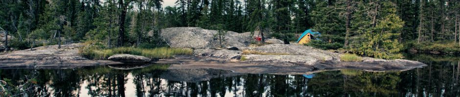


 Leafing through a copy of Kevin Callan’s A Paddler’s Guide to Ontario’s Lost Canoe Routes, I found an account of a trip down the Steel that he had done with his wife Alana sometime around 2003.


 As well as paper copies of the Federal Govt. Topos, we each have a Garmin GPS unit – the Oregon 450 and the Etrex 20 – with the latest Garmin Topo Canada v 4 maps on it. (It is listed at an incredible $181. CDN in early 2018. We paid $110. back in 2011.) While not as accurate as the NRC maps, they serve as backup and provide a ready answer in those situations where you can’t figure out exactly where you are! We also like the waypoint and tracking features and how the eTrex and Oregon archive each day’s progress.


 The Ojibwa of Southern Ontario by Peter Schmalz (1991) is another worthwhile book to get. The Amazon summary describes it like this –


