
Last revised: October 19, 2022.
Previous Post: Peterborough’s The Canadian Canoe Museum – Journey Into An Epic Past
Related Post: Anishinaabe Rock Art
N.B. The term Algonquian (also spelled Algonkian) refers to one of North America’s largest indigenous language families. Individual tribes or First Nations like the Innu, the Abenaki, the Mikmaq, the Algonquin, the Nipissing, the Ojibwe (Chippewa in the U.S.),, and the Cree all speak a version of Algonquian. (See here for a primer.) These people know themselves as Anishinaabe, the Original People.
A one-hour drive from Peterborough and the Canadian Canoe Museum, and we were approaching the entrance to Petroglyphs Provincial Park. It is a day-use-only park with hiking trails, but its real reason for existing is the 90′ x 120′ outcrop of gently sloping white marble (limestone) in the center of the park.
____________________________
Click on specific headings to access directly:
- The Site Is Discovered/Uncovered
- Who carved the images into the rock?
- Who is responsible for the site these days?
- The most detailed study of the site
- Three Main Things To Do At Petroglyphs Park
2. Lloyd Walton’s film The Teaching Rocks,
- The Teaching Rocks on Youtube
- Fred Wheatley’s Advice To Anishinaabe Youth:
- A Misrepresentation of the Past:
- Exploring the Historical Past:
- The Request For No Photos
- Controversy over the Building Over the Rock Face
- Inside The Building
- What do the images “mean”?
Useful Links For Further Exploration
Also, check out the Comments for what some readers make of all this!
____________________________
The Petroglyph Site Is Discovered/Uncovered:
Peterborough Petroglyphs – Everett Davis
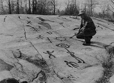
In 1954 a prospector, Everett Davis, sat on this rock face as he surveyed the area east of Eels Creek and north of Upper Stony Lake. He had been there before but had never noticed anything special; this time, the sun’s light hit the rock just right, and the images came out of the rock – some recognizable as humans or animals and others more abstract or fantastical. As he pushed away the leaves and moss covering some of the sloping rock outcrop, more and more petroglyphs were revealed. He did not know it at the time, but he was standing on one of the largest petroglyph sites in Canada. He also did not know that someone else had come upon it thirty years before! As the ministry account of the park’s history (see here) notes:
The petroglyphs site was discovered in 1924 by Mr. Charles
Kingam, a local resident and a member of the Peterborough Historical Society. His discovery was not widely publicized.
While little came of Kingam’s “discovery,” a year after Davis, the Royal Ontario Museum sent a U of Toronto team led by Paul Sweetman and James Gooding to examine the site. Based on a quick mapping of the site and their identification of about 100 petroglyphs, the Museum published an account of their findings – A preliminary report on the Peterborough Petroglyphs – in 1955.
Davis found the site overgrown and covered in places with grass, shallow-rooted plants, and deadfall. In the photo above, the debris has been cleared away. The cavities of the petroglyphs look like they have been coloured. The Sweetman/Gooding crew used charcoal crayons to aid in their visibility and identification. In the mid-60s, the Vastokas team also used charcoal crayons to make yet more glyphs easier to see.

entrance to Petroglyphs Provincial Park from Highway 56 (Northey Bay Road)
Who carved the images into the rock?
Since 1954 – and especially since the late 1960s – the site has seen increasing numbers of curious visitors. Wild theories popped up to explain the nine hundred or so marks and images – many of them difficult to see – hammered out of the rock face. Who put them there? Phoenicians, Vikings, and Celts were just some of the suggested answers. As entertaining as they may have been, the explanations of people from far away do not stand up to any serious examination of what we know about those cultures and their iconography.

Milwaukee Journal headline from October 27, 1962
The answer lies much closer to nearby Stony Lake. The territory lies on the southern edge of the Canadian Shield. Before the arrival of the Europeans, it was in the cultural transition zone between Algonkian-speaking communities (the Anishinaabeg) to the north who lived in small mobile hunter-gatherer (foraging) bands and Iroquoian-speaking communities (the Wendat and Haudenosaunee) with their larger and more advanced agriculture-based villages to the south.
The answer to who hammered out the images on the relatively soft limestone rock face can be traced back to one of these two Indigenous Peoples. Since there is no evidence – for example, common iconography at other sites – connecting the Iroquois with the petroglyphs, we are left with one of the Algonquian-speaking peoples.

some major pictograph sites in Ontario
Many of the images on the rock have parallels with pictographs at other sites on the Canadian Shield known as Algonquin, Ojibwe, or Cree. Oiseau Rock on the Ottawa river and Mazinaw Rock in Bon Echo Park are two well-known Anishinaabe pictograph sites. Thus, placing the petroglyphs in an Algonquian context fits the evidence best.
The map below (see here for the source) shows the extent of the Iroquoian world before contact with the Europeans. Note that the northern boundary passes just below the north side of Stony Lake and shows the estimated extent of Wendat – i.e. Huron – territory before 1550.

The map is from a 2015 paper titled “Current Research on the Historical Development of Northern Iroquoian Societies” by Jennifer Birch in the Journal of Archaeological Research. It represents the current consensus view of archaeologists of the extent of Iroquoian settlement during the 1000-1550 CE period.
Burleigh Falls and Stony Lake mark the southern edge of the Canadian Shield. While the Iroquoian-speaking groups were not a people of the Shield, the Anishinaabeg certainly were.

an Anishinaabe shaman hammering out images – see here for the source
Since carbon dating a petroglyph is not possible, the discovery of other datable material at the site helped set a rough parameter for when it was used. Found in the crevasses of the rock were bits of pottery – the remains of small offering bowls? – which were dated back about 1000 years, placing it in the Woodlands Period of pre-European Contact archaeology. At the very least, this puts the creation of the petroglyphs pre-contact – i.e. before the arrival of the French in the early 1600s.

Who is responsible for the site?
In 1976 the Ontario government of the day created a new park – Petroglyphs Provincial Park. Since 1990 Ontario Parks has managed the site along with nearby Ojibwa Curve Lake First Nation members, whose ancestors first moved into the area in the early 1700s. Their present community is found on the peninsula between Lake Chemong and Buckhorn Lake, southwest of and above Burleigh Falls. (See here for a Google map view.)

Burleigh Falls below the bridge – water tumbling into Stoney Lake
It is about a forty-kilometer hike and paddle from the petroglyph site to their community. However, the area may have been considered the hunting grounds of one of their families before the lumbermen, farmers, and miners started arriving in the 1850s. While the Ojibwe community has no direct link to the petroglyphs, the 2015 Park Information Guide informs us that –
Today the local First Nation of Curve Lake acts as a steward of the petroglyph site providing Ontario Parks with guidance in this culturally significant and ceremonial place.
This guidance is presumably because the site’s current “spiritual caretakers” share some cultural traits with the creators of the petroglyphs, in particular, a mythological worldview that they can use to explain the meaning of the images. The ongoing mystery about the exact meaning of the petroglyphs shows how tenuous that cultural connection really is.

The mid-1980s structure – 35′ high with lots of windows – was built to protect the petroglyph site
The Vastokas Study of The Site:
For almost thirty years after the site’s discovery, it received only a minimum of attention from authorities. At first, it was completely open, and one could walk over the rock face. Eventually, concerns about the deterioration of the site – and a few examples of graffiti left by unthinking visitors – motivated officials to erect a series of increasingly serious fences to keep people away from the sloping rock face while still permitting it to be viewed.  In the mid-1960s, Joan Vastokas (then of U of T) and Romas Vastokas of Trent U in nearby Peterborough began their study of the site with their students. Among other things, they used a charcoal-coloured crayon to enhance some of the petroglyphs so that they could be better seen. Their findings were eventually written up in Sacred Art of the Algonkians, which was published in 1973. Almost a half-century later, it remains the definitive study of the site. It is also a difficult book to get a hold of – in December 2020, an Amazon seller had a used copy available for CDN $556.86 + $5. for shipping! The Toronto Public Library system does not have a single copy.
______________________________
The Internet Archive site has a digital copy of the book!

July 2021 Update: A digital copy of the book can be found at the archive.org site! While it cannot be downloaded as a PDF or other file, it can be borrowed for one hour at a time. Signing up with the Internet Archive site is free. Click here to access the site.
______________________________
Update: After this post was written – but before I found the archive.org site – I stumbled upon this brief passage from the Vastokas book. It examines the history of the site and its connection to those First Nations people now living near it. It supports some of what you’ll read in this post:
“. . . there are no indications that the early settlers or the government survey teams ever came across the site in the course of lumbering, hunting, or exploration. Nor are there any references in the pioneer literature of the area to suggest that the native inhabitants at Chemong Lake or Rice Lake had any knowledge of the petroglyphs.
At the turn of the nineteenth century, Stony Lake and the streams and lakes in its vicinity were apparently claimed by the Ojibwa chief Handsome Jack as his hunting and fishing grounds. However, among the interesting details collected by Pelham Mulvaney in 1884 about Handsome Jack, his family, and their lands there is no mention of the petroglyphs.
In 1904, Chief Robert Paudash, a Mississauga from the Rice Lake settlement, recorded the oral traditions concerning the coming of his ancestors from the north shore of Lake Huron to the Trent Valley. Robert Paudash came from a long line of hereditary chiefs and was capable and anxious to record the achievements of the Mississaugas; had he known of the Stony Lake site he would have probably referred to it in the context of the Rice Lake Serpent Mounds, whose authorship he attributed to his forefathers.
In addition, it should be borne in mind that when the Mississaugas arrived in southern Ontario in the eighteenth century, they had already been exposed to considerable contact and trade, and that some of the elements of their new culture might have found their way into the array of engraved forms. There is nothing in the site, however, to suggest European contact.
At the present, therefore, it is not possible to establish a direct link between the native inhabitants at the nearby Chemong Lake and Rice Lake settlements and the petroglyphs at Stony Lake. Nor is it at all likely that the artists were the Ontario Iroquois who occupied sections of the Trent waterway during the fifteenth and sixteenth centuries.
The most probable conclusion that can be drawn on the available evidence is that the petroglyphs were engraved by prehistoric Algonkians at the latter end of the Woodland period, sometime between 900 and 1400 A.D.” (Vastokas.1973:26-27).
See here for the online source of the above Vastokas exerpt.

do and don’t sign at the entrance of Petroglyphs Provincial Park

The Canadian Heritage Site Plaque beside the site

Petroglyphs Park after the parking lot
What To Do At Petroglyphs Park:
Besides the various hiking trail options, three other activities are available to visitors.
- It begins at The Learning Centre and its various poster displays.
- continues with a brief 18-minute Lloyd Walton film overview of Ojibwa culture and
- concludes with a visit to the petroglyph site itself.
I’ll take a look at each one in turn. Click on the highlighted text above to jump directly to one of the three.
1. The Learning Centre
The Visitors’ Centre, also called The Learning Centre, opened to the public in 2002 and is where the visit to the site begins. While the building has a small gift shop with various souvenirs and a movie theatre with seats for perhaps 80 visitors, the main attraction is a colourful multi-panelled poster display. We spent some time reading our way through the various snippets of text. I had expected an introduction to the petroglyphs and their meaning to be the main focus, but it soon became clear that something else was being presented here.

welcome center (The Learning Place) display
The wall in the photo above, nicely decorated with Norval Morrisseau-esque spirit lines emanating from the sun symbol, sums it up. “A culture is a living thing.” The folks responsible for the exhibit have used this space to present an updated version of indigenous spirituality, an adaptation felt to be more relevant to the late 1900s than the original paleolithic foraging culture. Pretty much absent is any reference to the animistic beliefs that ruled the lives of the actual people who created the petroglyphs.
The “Ecological Indian” Myth
 Since the 1960s, a new indigenous spirituality has centered on the “Ecological Indian” myth. One expression of this would be the fictitious “speech” falsely attributed to Chief Seattle, popular and posterized and found on many university dorm walls in the early 1970s. In the article “The Myth of Chief Seattle,” William S. Abruzzi makes this observation:
More recently, with the growth of large environmental and counter- cultural new age movements, a new Indian image has emerged. Native Americans have become the repositories of a traditional wisdom to those challenging institutionalized beliefs and practices in contemporary industrial societies. However, this latter-day Indian stereotype represents yet another white fiction serving the interests of those who believe in it.
I didn’t realize it then, but this modern blend of New Age spirituality and environmentalism as a defining feature of being aboriginal is now a widely held view.
On the Assembly of First Nations website, for example, I found this statement –
Indigenous peoples are caretakers of Mother Earth and realize and respect her gifts of water, air and fire. First Nations peoples’ have a special relationship with the earth and all living things in it. This relationship is based on a profound spiritual connection to Mother Earth that guided indigenous peoples to practice reverence, humility and reciprocity. (see here for source)
It left me wondering where a non-Indigenous person fits in. Presumably not as a “caretaker” since (s)he lacks “a special relationship” and “profound spiritual connection to Mother Earth.” This race-based approach parallels the stance taken in many of the world’s religions – also built on the notion that this select group of people has a special relationship with the Great Spirit. In the Tanak (the Jewish “Bible”), for example, this relationship is called a covenant, and the ones making it with the Great Spirit are His Chosen People.
Having established this special relationship, the next step is to claim possession of some sacred text with the very words of that God in it. Or, if not a book, then at least some sort of special knowledge for pre-literate societies. In the case of the Algonkian-speaking cultures, it is referred to as traditional knowledge supposedly not accessible to “outsiders.”

The Teaching Rocks – building a new worldview on ancient rocks

It is a place where we come to reflect…
Naming The Site
The Vastokas study described how the site was probably used:
…the suggested role of petroglyph sites in Algonkian culture as sacred places where communion between man and the manitous was possible; “it is said here that formerly, within the memory of the living, the place was visited by Indians who wish to consult the gods (manitous)”61 This statement documents the additional aspect of petroglyph sites in Algonkian culture as oracles, where the manitous might be encountered and where their messages might be received.
While the original purpose of the site can be guessed at –
- a site visited as part of a vision quest
- the shamans’ source of medicines or guidance from resident manitous
The Learning Center repurposes the petroglyph site for interested Anishinaabe as they live their lives in the 21st C. It has turned into Kinoomaagewaabkong (The Teaching Rocks), a site where select youth were bought by spiritually advanced elders to be introduced to deep religious mysteries. Waabkong may refer to the waabi (white) kong (rock) that the images are carved on; kinoomagge means “to teach.” There are a few different transliterations of the name, including Kinomagewapkong and Kinomägewäpkong.
The name Kinoomaagewaabkong or its translation, The Teaching Rocks, does not appear in the Vastokas study (1973). The 1977 Ontario Govt. Park Master Plan does not make use of the phrase either. The first reference to the name (that I found) was the title of Lloyd Walton’s short 1987 documentary. He used the term Kinomägewäpkong and the English translation.
By then, the site had become a destination for visiting participants of the annual Trent University-hosted Elders’ Gathering, held in Peterborough since 1970. It was the likely source of the new interpretation of the site and its name. Earlier use of the name may appear in some of the material published by the Elders’ Gathering in the late 1970s or early 1980s. Wintertime visits were possible with the construction of the building covering the site in 1985.

By 1996, Basil Johnson would include a discussion of The Teaching Rocks in his book The Manitous. He writes:
Besides these sessions, there were other teaching methods that might be regarded as formal. Certain youths, selected for their strength of character, breadth of mind, and their kinship with the manitous were taken to the kikinoomaukaeassin (the teaching rocks), where they were taught the wisdom and the knowledge of the Anishinaubae people by the elders, through stories represented by symbols inscribed on the face of the rock or impressed on birch bark. The purpose of these tutorials was to prepare the candidates to be the future custodians, interpreters, and teachers of the cultural and spiritual heritage of the people. And when their time came and they still led exemplary lives, they would succeed their tutors as “elders,” by virtue not of their age, but of their knowledge, wisdom, and integrity.
His account of the site’s use echoes that of Fred Wheatley in Walton’s film. Johnson gives The Teaching Rock the name Kikinoomaukaeassin, a somewhat different rendition of the name.
Given the Roman Catholic education that both Wheatley and Johnson received as youths, it sounds like they are describing a Jesuits-in-training institution! In the documentary, Wheatley says –
Years ago a child who was very active, with his legs going who was obviously going to be a smart person would be brought to the petroglyphs to be trained (like a priest). It was not for everybody but for someone who would become an elder and a priest in his own right.
It is unclear why Wheatley would associate fidgetiness with superior intelligence or if only males were taken to the site. If culture is indeed a living thing, then the response today would surely stress that a girl could also become “an elder and a priest in (her) own right.”
Richard Wagamese’s Indian Horse: A Novel (2012) also references the Teaching Rocks. It paints a different picture of the site’s purpose:
Then one day Shabogeesick called everyone together in a circle on the teaching rocks where the Old Ones drew stories on the stone. The people were only ever called to those sacred stones when something vital needed to be shared. No one knows where that place is today. Of all the things that would die in the change to come, the way to that sacred place was perhaps the most grievous loss.
As the eye-catching Learning Center poster says. “Culture is a living thing.” It does indeed change to suit new realities. The petroglyph site is a compelling focal point of cultural renewal/recreation.


A statement of the environmental ethos of contemporary Anishinaabe culture but with traditional gender-assigned roles still intact!
The above poster alludes to the possibility that the Anishinaabe (i.e. Ojibwe) once lived on the shores of the Atlantic at the mouth of the St. Lawrence River. From details of the various accounts told by members of the Midewiwin (the shamans’ exclusive medicine society) to William Warren in Minnesota in the 1840s, some scholars date the migration westward towards Lake Superior somewhere around 1350. They connect it to the arrival of the Black Plague along with European fishermen on the eastern shores of North America at that time. If so, it clashes with the vague “since time immemorial” notion of Anishinaabe presence around the Great Lakes. It is likely as unhistorical a story as the legend of Moses and the Israelites and their similar journey to a Promised Land.

Changing one’s worldview in response to changing times is not uncommon. It is also not uncommon to reinterpret and repurpose older cultural expressions – like the petroglyphs – which you did not have a hand in creating and which you can make no special claim to understanding. While the sentiment expressed in the poster above is laudable and may well be true to those who now visit the site, there is no basis for the claim that this is what the rock was all about.

If our legends fall silent…there will be new legends and new heroes

The Turtle …

Shrouded in mystery but yet having much to reveal.

What The Bear Teaches …

Miigwech…to Mother Earth (Aki)
The Learning Centre reveals surprisingly little about the meaning of the petroglyphs we are about to see. The primary focus is on Mother Earth and how we should treat it – perhaps given the difficulty of saying much about the petroglyphs, the hope is that this environmentalist focus will give visitors an acceptable alternative lens through which to see the images on the rock face.
____________________________
2. Lloyd Walton Film: The Teaching Rocks.
We moved on from the poster displays to the movie theatre. My brother and I were the only two there that afternoon but the Park Ranger – I did not get his name – graciously set up the film for us to watch. Entitled The Teaching Rocks, the nineteen-minute documentary-style film was released in 1987.
The Ontario Ministry of Natural Resources commissioned the cinematographer Lloyd Walton to direct the project; Fred Wheatley, an Ojibwe language teacher at Peterborough’s Trent U as well as an Ojibwe elder, did the narration. Not clear is if he also wrote the film’s script or whether others, like Peter O’Chiese, the charismatic elder from Alberta, also provided input to the script.
See here for a transcript of the film’s narration, along with some additional commentary.
The Vimeo website, which once hosted the film, had the following brief summary:
A visually arresting film, concentrates on the native art of the Ojibwa tribe. Much Ojibwa history and philosophy has been related through the rock carvings and paintings which are featured throughout this work. The voices of the Elders are heard in the film, describing the tales of creation and existence that mark the group’s iconography. A sense of mystery informs this evocative film as the realization strikes that no individual can expect to penetrate the mythos of the Ojibwa.
The Teaching Rocks On YouTube
In April 2021, the documentary was uploaded to YouTube. See the full-screen version by going to YouTube.
The film begins with a scrolling text which tells us that “the precise meaning of the petroglyphs are carefully shrouded in mystery.” This puts a positive spin on the difficulty of entering into the minds of those who put these images and markings here 800 years ago. Given that the documentary is meant to teach us about the culture behind the images hammered out on the rock face, it makes remarkably little use of traditional Algonkian/Ojibwe myths and legends. Missing is any discussion of Thunderbird and Mishipeshu, of Nanabush and the Giant Beaver.

early 1960s Norval Morrisseau painting of Animikii (Thunderbird) and Michipeshu (The Great Lynx)
What we are offered instead are modern-day musings on the environment as Mother Earth becomes the central mythic figure. Walton does combine some nicely filmed scenes of the rocks and water of the Canadian Shield, as well as shots of pictograph sites at Agawa Rock on Lake Superior and Lake Missinaibi, and I think a couple of seconds of Mazinaw Rock.

a stretch of Mazinaw Rock
Fred Wheatley’s Advice To Anishinaabe Youth:
On top of close-up clips of the animals of the Shield country – the moose, beaver, bear, and heron – the narrator provides a commentary emphasizing the same environmentalist ethos presented by the displays in the Learning Centre. The narrator – he speaks as an elder – tells us that –
We were put on this earth to look after our mother, the earth … Every blade of grass has a right to grow and whenever you set your tipi up, or your shelter, don’t leave it there for long because you will kill the grass if you leave it there. That’s why the Great Spirit has given you a strong body to be able to do these things…
Given that the narrator was an Ojibwe language teacher at Trent University in Peterborough with a classroom in a large concrete block on the banks of the Otonobee River, you have to wonder just what he was seriously advocating other people to do. At the same time, he showed up to teach an Ojibwe language class in a grass-killing structure.
Elsewhere he says this –
It is up to us to go back to our traditional ways and to try to warn the white man before he has poisoned the whole earth. Don’t contribute to the mess that’s being made…
Consider the usefulness of this elder’s ethnocentric “wisdom” for today’s young Ojibwe as they try to find a meaningful role for themselves in the world which they are told is poisoned by the “white man,” who is presented as the ignorant and greedy despoiler of “our mother, the earth.”
Romanticizing the past – advocating a return to an indigenous past that never actually existed – surely is not the answer. And just what do “traditional ways” include? Do they include: Money? Electricity? Cell phones? Snowmobiles? Rifles? Boats with kickers? Literacy? Modern medicine and surgery? Hip-hop music? Gambling casinos? Speaking English or French? A house that you live in all year round? A teaching job at one of the settlers’ universities? Will “traditional” ways include white dog sacrifices? Special isolated menstruation huts? Vision quests?
A Misrepresentation of the Past:
To emphasize the harmonious nature of life before the coming of the white man, Wheatley tells us of the annual month-of-May Ojibwe “meetings with the Sioux on the south shore of Lake Superior to exchange medicines.” The word “Sioux” is Ojibwe in origin and has the uncomplimentary meaning of “little snake.” [For the Ojibwe, the Iroquois were the big snakes.]
Known to themselves as the Dakota or Lakota, the “Sioux” were neighbouring people who lived at the west end of Lake Superior. When the Ojibwe moved into this area from further east around 1650 to 1700, they battled with the Dakota for control of this land. For generations, there were back-and-forth raids and battles between the two cultural groups for control; the Ojibwe won out, and the Dakota moved further west.
For generations, the Ojibwe were also at war with the Iroquois tribes. This is in the historical record; Wheatley presents a pre-European-contact paradise that never existed. This may suit his purpose, but it gives those watching the film a false idea of how things were.
_____________________________
Exploring the Historical Past:
 (Access here a PDF copy of George Copway’s 1851 book The Traditional History and Characteristic Sketches of the Ojibway Nation
Check out Chapter 5 for his account of those wars. Copway was an Ojibwe from the Trenton area to the east of the petroglyph site. He was born in 1818. Note: He does mischaracterize the relationship between the Wendat (i.e. Huron) and the Ojibway. The two actually fought together to soundly defeat the upper New York State Iroquois in the 1690s.
————————–

Click here to download a copy of William Warren’s History of the Ojibways, Based Upon Traditions and Oral Statements, written in the late 1840s. He provides detailed accounts of the Ojibwa conflict with the Dakotas. The edition linked to here is the free 1st ed.
A  much better second edition was published in 2009. Edited and annotated by Theresa Schenck, it also includes an excellent introductory section. The Amazon write-up of the book states this –
William W. Warren’s History of the Ojibway People has long been recognized as a classic source on Ojibwe history and culture. Warren, the son of an Ojibwe woman, wrote his history in the hope of saving traditional stories for posterity even as he presented to the American public a sympathetic view of a people he believed were fast disappearing under the onslaught of a corrupt frontier population. He collected firsthand descriptions and stories from relatives, tribal leaders, and acquaintances and transcribed this oral history in terms that nineteenth-century whites coul understand,focusing on warfare, tribal organizations, and political leaders.
————————–
See also this article – “The Ojibwa-Iroquois War: The War The Five Nations Did Not Win” for a comprehensive and well-researched summary that sets the record straight.
————————–
 The Ojibwa of Southern Ontario by Peter Schmalz (1991) is another worthwhile book to get. The Amazon summary describes it like this –
The Ojibwa have lived in Ontario longer than any other ethnic group. Until now, however, their history has never been fully recorded. Peter Schmalz offers a sweeping account of the Ojibwa in which he corrects many long-standing historical errors and fills in numerous gaps in their story. His narrative is based as much on Ojibwa oral tradition as on the usual historical sources.
Schmalz provides an excellent summary of the Ojibwa-Iroquois War of the late 1600s. See Chapter 2 –Conquest – “By the Power of the Great Serpent.” The book is available on Amazon here.
————————–
Today’s petroglyph site is presented as “The Teaching Rocks,” a place where select young people were supposedly taken as a step in the initiation into becoming shamans. Using the images on the rock as teaching tools, Wheatley states that the young person would learn some of the truths that he would need to become a medicine man in his own right.
It is unlikely that the creators and original users of this rock face used it in this way. Here, we have a modern repurposing of the rock face to fit in with the reality of a contemporary Ojibwe culture being swamped by external cultural forces. It is an attempt by its political leaders and creatives to develop a focal point for cultural revival three hundred years after the deluge began.
____________________________
3. The Petroglyph Site
The Request For No Photos
As we approached the petroglyph site, another sign reminded us again! – that given the sacredness of the site, no photography is allowed. The stated intent is to reinforce the deep spiritual significance of the site. Is it because taking photos would rob the site of its essence – just as some of our ancestors believed that their souls would be stolen if their photo portraits were taken? Given the cell phones with cameras that almost everyone has these days, this must be tough to enforce.
I think back at pix I’ve taken on the Temple Mount in Jerusalem, the Sistine Chapel in Rome, or, more recently, at the most sacred Buddhist site in Myanmar – the Shwedagon Pagoda – with its gold-plated stupa and relics said to be of the Buddha himself. The Myanmar site even provides visitors with free internet access on the temple grounds! The reason for the “no photo” rule here feels, more than anything else, like petty politics. Having let the folks on duty know my view on the matter, I did abide by it.

Notice at the entry to the fenced site
We walked through a gate in the fence, which I assume rings the entire site and separates it from the rest of the park. The photo below sets the scene as you approach the site. The structure covering the petroglyph site was built in 1984. The glass walls reach a height of about 40′ (12 meters) and let in a fair amount of subdued light.

approaching the petroglyph site
Not far from the site, archaeologists – perhaps the Vastokas team – found gneiss rock hammers that the creators of the petroglyphs used to peck and grind out the images. Somewhere nearby, there are two smaller petroglyph sites. The 1977 Master Plan for Petroglyphs Park provides this information –
One of the smaller sites is directly north of the major concentration, while the other site is 250 m to the northwest.The second small site consists of 23 distinct glyphs. In addition to these sites, there are a few glyphs scattered through the peripheral areas of the site. (Click on the title above to access)
Should The Building Have Been Erected?
The covered structure over the petroglyph site
Not everyone is happy about the building covering the site. Joan Vastokas, mentioned above as one of the authors of the still-definitive study of the site, has said that the structure itself is the biggest act of vandalism that has been done to the site!
At the end of the post is a link to a paper written by Dagmara Zawadzka of Université du Québec à Montréal (who studied under Vastokas), which gives a similar negative assessment of the Ontario Parks solution to protect the site.
I photographed the information board – see below – in which the Park officials present the reasons for doing what they did.

Peterborough Petroglyphs Site Info Panel – Part 1

Peterborough Petroglyphs Site Info panel – Part 2
My view on the building – while it may not be perfect, it was the best solution to the realities of the soft limestone rock and the need to protect the ongoing erosion of the petroglyphs from the environment and the impact of visitors walking on the surface of the rock.
____________________________
Inside The Building Covering The Site:

See here for the source of the image
Once we entered the building itself, I did not take any more photos. For study purposes, it would have been nice to have a set of images that I could examine in more detail at my leisure. We did have the benefit of having the park official – the same young man who had set up the movie for us – as a guide. We had him to ourselves for about forty-five minutes, and he gave us a fantastic tour of the rock face, taking us from one end to the other and pointing out key petroglyphs and some of the meanings given to them and their supposed relationship to others nearby. Only two other people – a young couple – came in while we were there. Their five-minute visit left us wondering why they had even bothered coming all this way.
As you enter the building, there is a rack with pamphlets available; they explain the overall significance of the site, as well as a few of the dominant images. The tone of the pamphlet is more like what I had expected at the Learning Centre. Also on the wall was a 24″x36″ or so drawing of the rock face and its many petroglyphs. I’d imagine it is from the Vastokas book mentioned above. At the end of the tour, the park official was good enough to take it off its wall hook and bring it outside the building, where I took a couple of photos of at least parts of it.

photo of a drawing of some of the petroglyph rock face
While this Wikipedia entry tells you that there are 1200 petroglyphs at the site – an unlikely high number – it does not go on to say that maybe 200 to 250 of them are still recognizable.

photo of the same drawing – the far corner of the rock face
In the above drawings, a few images jump out, probably because our minds can find some sort of meaning in them. Human forms and animal forms are definitely there, as are objects like canoes. Some are fantastical, and others are more abstract geometric forms.
The photo below was shot in 1970 and is one of a dozen that can be found on Jim Werner’s website. Serpents, turtles, a “rabbit-eared” human figure, the 56″ long crane, the attention-grabbing triangles…obviously, while the charcoal crayon which Vastokas’ students used to colour in the petroglyphs helps us see them better, we are seeing the site in a manner not thought of by the various people who hammered their images out of the rock. One could characterize the colouring of the cavities as an act of vandalism in itself.

Robin Lyke – Peterboro Petroglyph (1970) – used with permission of the owner
Update: I found the following image of the entire site in a Pinterest thread. It provides another perspective of the site –

Peterborough petroglyphs – sketch of the entire surface
————————–
What Do The Various Images Mean?
This is where you ask the question – what does it all mean? The first thing to recognize is that the images were not all put here at the same time. It is more accurate to picture the site as one to which the image-makers – the shamans? – came throughout generations to leave their mark for whatever purpose.
Having said that, it is important to resist the human impulse to take two adjacent images and create a “story” that explains their connection. Chances are they actually have nothing to do with each other. So – what is the key to unlocking their meaning?
There is no Rosetta Stone; there is no “grand theory of everything” which we can apply here. However, the images are the product of a particular culture with its set of myths and stories developed over time to explain all that they needed to explain. And what culture? As already indicated – the pre-European-contact culture of an Algonkian-speaking people like the Algonquin seems like a safe bet.
An interesting feature of the site is the number of crevasses and cracks in the rock face. One, in particular, goes diagonally across the entire rock face. Even more significant, there is a stream that passes underneath, and at least in the past, one could apparently hear the echo of the moving water. The sounds were given a spiritual twist and taken as voices of the manitous who dwelt in or under the rock. A parallel Ojibwe belief would be in the maymaygweshiwuk who lived in underwater caves associated with rock faces where shamans would leave their ochre images as a part of the ritual of obtaining favour or medicine from these spirits. Many of my posts on pictograph sites on the Canadian Shield have images of such rock faces.
————————–
Female Figure with Menstrual Blood?

Another interesting feature – and one that some people feel uncomfortable dealing with – is the holes at different places on the rock face. The Parks site pamphlet mentioned above discreetly omits this petroglyph from the discussion even though it may have been one of the first to be put there. Apparently, a seam of reddish iron oxide runs right through the figure and is thought to symbolize menstrual blood. The drawing can be seen directly above, and an internet-sourced image on the left makes it all clear – the image’s creator has incorporated the round pothole as female genitalia. On the upper body, one can make out a breast. On the day we were there, a small amount of tobacco sat on top of the outstretched right arm of the female figure, presumably left by someone as a part of a petition or a thanksgiving ritual.
————————–
Camel, Moose, or Mishipeshu?

Mishipeshu and the Snakes – Agawa Rock
In the third drawing above, a figure below the female figure has been interpreted as a camel! Notice the humps?

“Aha,” the “reasoning” goes, “So the Phoenicians really were here!”
It most likely is meant to represent a moose or caribou. Another possible explanation – one that comes from traditional Ojibwe iconography – is that it represents Mishipeshu. He is the underwater lynx who is seen as a counter-force to the Thunderbird (Animikii)) who is second only to Gitchi Manitou (the Spirit above all other spirits) in power. The famous pictograph of Mishipeshu at Agawa Rock bears similarities to the animal depicted here. It was only after contact with the Jesuits that The Great Lynx came to be associated with evil, right down to the devil’s horns on his head! Whether the cultural group that created these images actually shared the Mishipeshu myth with the Lake Superior Ojibwe is unclear.
————————–
The Serpent As a Positive Symbol:
Also very common on this rock face are depictions of snakes. Unlike the Christian spin put on the snake – Satan the deceiver in the Garden of Eden – for the Algonquins and Ojibwe the snake, often depicted with two horns (Mishikinebik) is a positive force associated with the medicine and wisdom that a shaman would have come for.

Norval Morrisseau – (1962) Serpent Legend – shamans being infused with spiritual power
The Park pamphlet puts it this way – “Because snakes live and move between the spirit worlds, they are often viewed as messengers from the underworld and protectors of the springs.” Look at the first photo of the drawings – not having any photos to double-check, I assume that whoever drew the images did so accurately! You’ll see three different snake figures with the double horns indicated. There are apparently thirty or so snake images at the site, with some of them incorporating the crevasses and cracks of the rock face.
————————–
A Reference To the Serpent Mounds At Rice Lake?

from the Rice Lake Serpent Mounds To Stony Lake Petroglyphs
However, the 1977 Parks document does provide a questionable interpretation of another collection of petroglyphs also featuring a serpent flanked by a row of small circular glyphs:
…one petroglyph depicting a snake with dots signifying eggs is a reproduction of the landscape of the Adena-Hopewell Indian burial ground at Serpent Mounds Provincial Park. See here for the source, p.36
The image below is the “snake with dots signifying eggs” petroglyph referred to in the quote.

This interpretation can be traced back to the Vastokas’ study from 1973.

It presumes that David Boyle was correct in his interpretation of the large burial mound as a serpent effigy and the other oval or circular mounds as “eggs.”
A Google search for a site map of the Serpent Mounds area turned up a sketch drawn by David Boyle, Canada’s pre-eminent archaeologist in the late 1800s, after his 1896 visit to the Rice Lake site, the first by an archaeologist.
The so-called snake mound is about 60 meters (200′) long, with the “head” of the snake pointing east/northeast and facing two small mounds. On the south side of the snake are other small mounds. Oddly, Boyle’s ground plan has flipped the layout horizontally; he has the head on the left (i.e.west) side.

Boyle’s fanciful sketch of the “serpent” mound 1896 -See here for the actual orientation of the mound.
To state that what is carved above is a “reproduction of the landscape” of the Rice Lake Serpent Mound is not supported by the facts and the reality on the ground.
While Boyle applied the name “serpent” to the mound in 1896, the two subsequent archaeologists to visit the site both cast doubt and, in essence, rejected his interpretation –
- Henry Montgomery, after a 1909 visit and
- Richard Johnson, after five years of work at the site with his Royal Ontario Museum/U of Toronto team from 1955-1960.
Below is the Johnson team’s sketch of Mound E, Boyle’s “serpent.” It lays to rest Boyle’s notion that the mound was meant to represent a serpent and that the serpent petroglyph with a row of dots on either side was meant to reproduce or show “a formal affinity” with the Rice Lake burial mounds.

For a deeper look at the Rice Lake Serpent Mounds, check out the following post –
The Rice Lake “Serpent Mound” – Chronology, Sources, And Cases Of Mistaken Identity
————————–
Mikinak – The Turtle:

Petroglyph Park turtle image
Another animal figure which figures prominently on the site is the turtle Mikinak. It is seen at pictograph sites across the Algonquian world and represents the messenger who brings the manitous’ communication to the shamans. At this site, there are a dozen turtle images – one depicted in the image to the left. One interpretation has the dots as eggs which symbolize new life. There was even an explanation for the number of eggs – 13? – which I have forgotten. It is best to take many of the explanations with a touch of skepticism and resist the urge to create a story based on nearby glyphs.
————————–
Kitchi Manitou, shaman, or something else?
 One unusual image that provokes puzzlement is the one to the right. It seems to show the lower part of a human body and then a sun symbol on a vertical line interpreted as the upper body.
The park pamphlet states: “This large central figure near the centre of the site is thought by some First Nations to be a carving of ‘Gitchi Manitou…it may also represent a shaman who has been given powers by the creator.”
Given the transcendent nature of Kitchi Manitou (often translated as “Great Mystery”), it seems unlikely to have been thought of in human form. If the top and bottom are indeed one image, then the shaman filled with the Great Spirit is a more likely interpretation.
Missing from the phrase “some First Nations” is the qualifier “a few members of…”. Since most members of nearby First Nations communities have moved on from traditional pre-Contact Anishinaabe myth and religion, they would be unlikely to have given any thought to the image’s meaning.
Vastokas devotes a few pages to what she labels the “Sun-Figure” and provides parallels from other glyphs at the Peterborough site and from other pictograph sites.
The most striking one is from the Scotia Lake pictograph site in NE Ontario. It shows the upper body of a human figure with two concentric circles (and perhaps a dot in the very center) surrounded by rays.

Vastokas’ examination of the sun figure image and more can be accessed at the Internet Archive website here.
 Grace Rajnovch does not discuss the “Sun Figure” but does examine Anishinaabe symbolism, including the circle and encircled heads. See here for the relevant section in her Reading Rock Art for more. She states that the circle with a dot in the center (or, I assume, a smaller inner circle) can be interpreted as a non-anthropomorphic symbol for Kitche Manitou. That would explain the shaman’s head, infused with the Supreme Ultimate.

Diamond Lake pictos – the circle with a dot.
Selwyn Dewdney, in his examination of the Diamond Lake site in the 1960s, makes no mention of the Kitchi Manitou interpretation of the symbol and instead points out that two mid-1800s writers give different meanings for it –

Dewdney, Rajovitch, Schoolcraft, Copway – each with a different take on the meaning of this recurring morph.
The eminent Canadian archaeologist J.V. Wright, who worked at the Canadian Museum of Civilization for forty years, provides this summary of the Sun-Figure pictograph, its possible origin, and its usual interpretation. (Click on his name to access a brief bio.)

J.V. Wright. Peterborough Petroglyph – Gitchi Manitou?
[If the Vastokas pre-Contact dates for the petroglyphs are correct, it seems unlikely that the Abenaki would be hunting beaver that far west before the arrival of the French – and before it became an essential item of barter which they had depleted further east. ]
The image below also includes a second circle on a pole, but it is not attached to what one could interpret as legs with a torso. The site’s petroglyph cavities were coloured in with carbon crayons, and those who did the colouring may have emphasized or exaggerated certain aspects of the cavities.
Looking at the so-called Kitchi Manitou image, another interpretation comes to mind. Perhaps we are looking at two different pictographs, one done by chance on top of the other and not actually related or even done at the same time by the same person.
The fact that we link the two may say more about how the human mind works to create meaning out of coincidence than it does about what the rock carvers engraved in the rock face. Comparing the relative depths of the two petroglyphs at different points might provide some evidence.

————————–
Shaman With Turtle Rattle?
 Another image commented on in the pamphlet is one of what may be a shaman or “medicine man.” The object in the figure’s right hand “may possibly be a turtle rattle used in ceremonial practices. The cone-shaped hat over the person’s head may indicate his/her connection to the spirit world and the power of healing.” The shaman figures I have seen further west share some common elements with this one. Like this one, they are always standing figures who hold something in an outstretched arm. That “something” is interpreted to be an otter skin medicine bag. This image from the Bloodvein River is typical –

Artery Lake Pictograph Site- Face IV Shaman with Medicine Bag figure
While the Artery Lake figure does not have the conical hat, he does have what could be interpreted as a spirit line going into his head. Perhaps there is a parallel there? Here is a drawing from the Smithsonian Institute’s anthropological archives. It depicts a medicine man with a ritual object in his left hand, which he seems to be spinning or shaking –

Ojibwe shaman with rattle – Smithsonian Institute’s anthropological archives – see here for source.
————————–

the crane and the Nanabush figures
A physically large petroglyph is that of the crane or heron that you see in the image to the right. It measures some 56″ from top to bottom. According to the Park pamphlet, the crane “is a common totem bird among the different Algonkian peoples. Playing a relevant role in the world of shamanism, signified as helping spirits that aid in revealing prophecies, and they are receptacles of the souls of the dead, as birds can read the future. Members of this clan traditionally are the speakers at meetings.” (Someone at Parks Ontario needs to rewrite this passage!)

Mazinaw Rock’s Rabbit man panel
In the above photo, you will also find two images associated with Nanaboozoo or Nanabush, the rabbit-eared “trickster” of Ojibwe myth. The next day we would see a similar ochre pictograph at Mazinaw Rock – a human figure with two large “ears” protruding from his head. In all of southern Ontario – from Sudbury to the Ottawa River down to Lake Ontario- there are only two aboriginal rock image sites – Mazinaw Rock at Bon Echo and this petroglyph site. Interestingly, both are the biggest sites of their kind in Ontario – and maybe in Canada. See here for our visit to Mazinaw.

————————–
The walkway takes you right around the site. Every few meters, there is an information board explaining particular images. Normally I would have taken photos of them and reread them after the visit. The pamphlet deals with most of the ones I’ve covered above. It also has a bit to say about the canoe images, the Thunderbird, what looks like large arrowheads but which could be a shaman’s spirit (the pamphlet’s suggestion) or the silly suggestion made in that Milwaukee Journal at the start of the post (a Xmas tree!). I haven’t seen anything like it in all the pictograph sites I have been to – or seen images from.
More time and access to photos of different parts of the site would add more substance to my analysis. So would reading the Vastokas book!

Robin Lyke 1970 photo- used with permission from J. Werner – in this photo, the animal below her feet looks like a long-legged moose.
______________________________

Click on the header to access.
Jim Werner’s Website & Photos of the Petroglyphs:
If you want to see more images of the petroglyphs, the best collection I have found online belongs to Jim Werner; the photos were actually taken by his uncle Robin L. Lyke in the early 1970s. His website has an excellent site discussion and twelve images; you can access it here.
______________________________
Questions Answered/Answers Questioned
The drive to Petroglyphs Provincial Park took us about an hour from Peterborough. We had spent the morning at the Canadian Canoe Museum, so we got there at about 2:30. I am glad we took the time to finally check it out.
As is often the case, we left with more questions than we had arrived with – but isn’t that why we travel and check out things we don’t know about? We came knowing we would see the physical structure over the petroglyph site; we were left wondering about the ideological reconstruction of the site undertaken over the past fifty years.
This post was my attempt to grapple with some of those questions. I have a feeling that in the coming months, I will be returning to this post – rethinking, revising, researching, and replying to comments of those who may or may not agree with my view of things.
______________________________
Useful Links For More Insight:
1. The Ontario Gov’t’s 1977 Master Plan for the Park:
The 1977 Ontario Government “Master Plan” for Petroglyph Provincial Park is worth skimming through. You can access it here. I also took pp. 32-36, the section on the history of the site, and put it into a 1.2 Mb pdf file which you can download here.
Among the statistics in the report were the annual visits for 1974 (14,227) and 1975 (13,613). The most recent statistics I could find were for 2010 (13,254). If the stats are all measuring exactly the same thing, it would seem that fewer people are visiting now than forty years ago! If so, I wonder why?
______________________________
2. Dagmara Zawadzka’s academic paper on the site:
Dagmara Zawadzka of Université du Québec à Montréal has a 2008 paper accessible online as a pdf file.
It is entitled The Peterborough Petroglyphs/ Kinoomaagewaabkong: Confining the Spirit of Place. Concerned with the structure built over and around the petroglyph site in the early 1980s, her stated aim is this –
Due to the site’s uniqueness and popularity, the Ontario Ministry of Natural Resources (MNR) implemented measures to protect and conserve it, as well as to transform it into a tourist attraction. One such measure was the construction of a building directly on top of the site. In the following paper, I demonstrate that this building thwarts the understanding of the meaning inherent in this sacred Indigenous site, and that less intrusive and culturally sensitive conservation measures might be more suited for transmitting the spirit of the place.
Zawadzka only sees or chooses to acknowledge the physical building over the site by the MNR, not its ideological repurposing. A consideration of the role played by Trent University and the Elders’ Gatherings it hosted and which began in 1970, might explain how the site came to be redefined and revitalized. Likely, the new name now used for the site -Kinomagtewapkong – The Teaching Rocks – dates back to this time of “restor(y)ing” the site.
______________________________
3. Access To a Chapter On the Site by Joan Vastokas
Carol Diaz-Granados and James R. Duncan have edited a collection of papers in The Rock-Art of Eastern North America: Capturing Images and Insight (2004). Chapter 16 – The Peterborough Petroglyphs: Native or Norse? – is a contribution by Joan Vastokas. The teaser blurb begins –
This chapter discusses the ongoing debate over the Peterborough Petroglyphs and whether they were created by Native Americans or Norsemen. First, a history of the debate is covered positing the various theories. Then, forms of writing that have been compared to the Peterborough Petroglyphs are addressed and their similarities and differences explained. Throughout the chapter, I present evidence that concludes a Native Ameri-…
And they leave it at that! Given the author, we can guess what the conclusion is. Most of the chapter (except for three pages) can be read here at Google Books.
______________________________
4. A Wide-Ranging and Philosophical Approach To the Site and Its Meaning
Charles Lock is currently a Professor of English at the University of Copenhagen, but for twelve years (1983-1995), he taught at the University of Toronto. He has a 15-page paper in a 1994 issue of Semiotica (special edition on Prehistoric Signs) entitled “Petroglyphs In And Out Of Perspective.” It is available here. While written for an academic audience and occasionally an obtuse read (just like this post), it is worth the effort. He uses the Peterborough Petroglyphs to illustrate some of the points he makes about how and why modern scholars study “primitive” art. Here is a brief sample from the article:
Unlike prehistoric artefacts in Europe , but like mediaeval ones, the petroglyphs of North and Central America are still, or have become again, the focus of cult. The most famous petroglyph site in Ontario — near Peterborough — was discovered in 1954, and the Ontario Ministry of Natural Resources undertook to preserve ‘this important part of our national heritage … for future generations of Canadians’ (Sweetman 1955: 108). Fences of increasing seriousness were built to protect the site from visitors — not only from wear, but from the graffiti that graffiti always invites — until it was recognized that the main damage was caused by the weather. Before their discovery the petroglyphs had been well protected by moss and undergrowth. In the late 1970s the Ministry built a large structure over the entire rock surface; the atmosphere inside is now fully controlled. In 1976 the site was designated a Provincial Park . I first visited the petroglyphs in 1984, and my thought then was that as the petroglyph would not go to the Museum, the Museum had gone to the petroglyph. Sometime between then and my next visit in 1990 a wooden sign appeared, on the path between the car-park and the site, and visitors are now informed that this is a sacred place, honored and used for ritual purposes by Native Americans; non-Natives are asked to behave with respect. Native people are now the guides and wardens of the Park, and there is talk of the Ontario government ‘handing back’ the petroglyphs to Native Americans.
The way we view these petroglyphs has changed radically. No longer a museum, ideologically neutral and spatially homogeneous, the structure belongs to others and is to be entered on sufferance. Should one remove one’s hat? One’s shoes? Voices are lowered. And one certainly gets a ‘romantic thrill’ from seeing on that great rock, at a discreet distance from any carving, the traces of a tobacco offering. Visiting in 1992, however, I noticed not only tobacco and feathers and stones, but also red, yellow, and white ribbon. These ribbons are traditional and authentic, but my aesthetic sense inwardly protested that the effect was tawdry. With petroglyphs as with icons, offerings must be placed in contiguity with the object of devotion, and thus become part of it; one cannot open a site to cultic devotion and then ask that offerings be left elsewhere, to the side. As a visitor, one knows that one’s aesthetic protest would be, if voiced, a mark of disrespect. In a museum, of course, complaints are expected.
Here we have a rare and spectacular instance of a prehistoric artefact which is now serving what we might call a ‘first-order purpose’. Obviously there has been no continuity of cult; the Ojibway Anishinabe band, who now revere the site and care for it, do not pretend that it was ever associated with their ancestors. Whether the contemporary cult is the same or similar to that practiced in prehistoric times is of course unknown; indeed, not everyone is agreed that these petroglyphs ever had sacred significance or were at any time the site of a cult. Probability certainly favors the Ojibway, and whatever the authenticity of the present cult, it must be considered ‘first-order’: there is a consensus among Native people which legitimates the cult, and the ritual has nothing to do with ‘second-order purposes’, the aesthetic and cognitive practices of non-Native viewers. Viewers, spectators, scholars, helpfully raised on the ramp that encircles the rock, prevented by railings from falling (or straying) onto the rock, we notice the little gate through which Natives may pass: the way in, not for viewers but only for participants.
______________________________
5, An Alternative History Approach:

Robert Burcher has developed the unlikely argument that the petroglyphs result from an Anishinaabeg hunting party encounter with Celtic sailors some 2000 years ago. He writes –
The hunters, confounded and frightened, turned back into the safety of the forest. They raced north to a sacred site where they could communicate with their gods. They carved images of the invaders on an expanse of white rock in explanation, perhaps a warning, to their kinsmen who also searched these woods for food and fuel.
With this as the fantastical premise, Burcher’s book The Leather Boat fleshes out a tale in which Celtic-inspired images ended up in the limestone of the central Ontario wilds some 2000 years ago. Entering a world of fiction requires that the audience suspend its disbelief and accept certain things as “true.” Given the out-of-the-way location of the rock face, it would have had zero value as a place to put a warning to kinsmen; it also assumes they would even be able to “read” the supposedly never-seen-before images hammered into the rocks – especially the one on the book’s front cover of the Celtic ship – correctly!

Burcher is also a WordPress blogger; unlike me, he has a book for sale. See here for details! Alas, no copies in the Toronto Public Library system to sign out for a quick read.
______________________________
Next Post – We travel to Bon Echo Provincial Park and check out
The Pictographs of Mazinaw Rock: Listening For Algonquian Echoes

checking out Mazinaw Rock from the landing near our campsite


A very insightful consideration of what you saw and read. Thank you!
Insightful, and you are close. I made the film THE TEACHING ROCKS under heavy pressure on what or what not to reveal. The original inscriptions were recorded on hide and taken west for protection. My teacher, who died at the age of 108, had the hide. After 30 years I was given permission to tell the story and it will be published soon. the working title is INTO THE STONE, but it could be called, LLOYD ISN’T HERE.
Lloyd, it has been almost thirty years since you made that film! Thanks for pointing out something I did not consider – i.e. the constraints you faced in developing the film’s narrative. As for the scroll that will reveal all – and soon … well, I can see the Algonquian version of Dan Brown’s The Da Vinci Code in that story.
The way I understand it, the petrogplyphs were done by any number of people over an extended period of time and to impose some sort of narrative connecting the various images reveals more about the interpreter than it does the intentions of the original carvers.
You’ll have to put me down as skeptical about the notion that one buffalo hide – surely not contemporaneous with the carvers of 800+ years ago – would capture the “true” meaning of the numerous images on the rock, which are mostly unrelated except for the fact that they are the product of common Algonquian worldview and mythology.
I’ll be checking your website in the weeks to come to see if Into The Stone has been published!
It was a deer hide.
i have a strong interest in the petroglyphs. I appreciated reading your take.
Thank you.
David, a bit more than a year ago I knew nothing about the Peterboro Petroglyphs! Our brief visit provided me with lots to make sense of. My post was an attempt to reconcile what I’ve learned over the last three years in my pictograph-related canoe trips with what we saw at the site. I have yet to get a hold of a copy of the Vastokas study, still the major work on the site after all these years!
While I admit my “take” on the site does not fit in with the official narrative, it is nice to read a positive review! Thanks.
I have a spare copy of the Vastokas book. Not sure if I wish to part with it but I can lend it out.
Norm, thanks for the offer! If I could borrow it for a week or two that would be terrific! To think that it was written 45 years ago and is still the only serious examination of the site!
I could lend you a couple of related books as collateral!
I’ve got Thor Conway’s new book Discovering Rock Art as well as a copy of Grace Rajnovitch’s Reading Rock Art that you would probably enjoy leafing through (if you don’t already have them).
Do you live in the GTA? I live in the Broadview/Danforth area.
Email me at true_north@mac.com and maybe we can arrange something.
Thanks again!
I have finally finished my manuscript, titled POSITIVELY NORTH STREET, and it is out with a literary agent. The story builds to a four day teaching on the rock that I witnessed by an elder from the west. Records of all of the inscriptions were written down on a hide and taken west in the late 1700’s as part of the Ojibway migration.
This man, as he first said to me en route, “I have no reason to lie to you.” He also said, “A teacher knows what you need to know, and you have no right to ask me certain questions. I too have no right to answer you.” He proved beyond a doubt to all in attendance that he knew what the rock was teaching. My story also deals with the consequences of my resulting actions.
Lloyd, your title’s twist on a great Dylan song got my attention and the brief summary you provided make me even more curious about the story you have to tell. From your quote, it is clear that the shaman’s traditional philosophy of education was at odds with the way things unfold in classrooms these days!
I may have a question or two about that migration. I assume it was to the west end of Lake Superior? I thought that it happened perhaps a century earlier – i.e. around 1700 – when the invading Ojibwe began to displace the Dakota (i.e. the Sioux) nation then living in the upper Mississippi region.
They first went to Montana, then the Waterton Lake area, then up into Alberta, living beyond the settlers, and spooking the local aboriginals with their intense spirituality.
There was a comment about the film not talking about myths. What I was told by the Mishomis was, ” These are not the things of dreams. Every thing on this rock can be proven. ” And he went on to prove it.
Thanks for the clarification. I’m looking forward to reading your book. I hope it’s coming along! Just started reading Michael Angel’s Preserving the Sacred: Historical Perspectives on the Ojibwa Midewiwin.
Truth
Just ran across this site. It is very interesting and thanks to all those who commented too.
Seeing the “picture” of the petroglyphs, what struck me was the idea that much of what was there was a map or an atlas, not just a spiritual landscape but a mainly practical one. Waterways were clearly marked, in my view, oriented specifically to give the direction . It was as if they were answering the questions one might have had as to the best places to get stone/flint for spear/arrowheads….how to get to the best hunting area for moose etc. Not everything pertained to food and other important but worldly concerns but my guess is that much of it did.
Seeing the lines linking a series of ovals might indicate part of a path on water ….traversing the number of lakes (or widened areas) shown. Scale was irrelevant but perhaps some of the nearby symbols indicated the number of days travel.
What appears to be a snake with a series of dots on each side could be a more detailed map indicating a river and the dots indicating major outcroppings of rock or cliffs…think of it as a representation of what we might see on a satellite photo.
The twists and turns would not be shown because they were irrelevant, it was navigation by rock signposts perhaps.
Any comments?
Rich, your theory is an interesting one. As you read on, you’ll see I think it misses the point of the petroglyphs. I am sure you will think I’ve missed your point!
The Petroglyph site is in an out-of-the way spot above Upper Stony Lake. It may have been chosen for that reason. It reminds me of the Cliff Lake pictograph site in NW Ontario. It too is somewhat removed from major river corridors of travel and was obviously a hallowed spot visited often for generations. What drew them to the Stony Lake site was the underground stream running under the rock which made a gurgling sound and which was probably associated with the manitous dwelling there. It would provide the reason to visit the site and leave a growing collection of images over time – that is, over three or four hundred years by generations of carvers, each with his own small contribution to make.
The small band of Algonkian hunters/gatherers would probably camp nearby on Stony Lake – perhaps at Burleigh Falls – for the summer season while they fished and gathered berries. this would also be the time for meeting up with other small bands. It would be one of the stops on their annual circuit; by the fall they would have moved on in small groups to the moose hunting grounds in the interior to the north.
You suggest that the site may actually be a map or atlas of their everyday world. This would mean that the entire site was chiseled by a team of people – the elders who knew all the details of the migratory pattern their band followed.
A similar theory I have seen is that the rock face represents a map of the heavens – an atlas of the cosmos.
The problem I have with these theories is that they totally ignore the culture of the people who visited the site and impose on it the way of thinking of another culture. Instead of understanding Algonkian spirituality and mythology on its own terms, we have them think like we do.
A practical question might be – Why bother carving a map of their world – the annual circuit they travelled – on this rock face? Given that for most of the year you would be far away from the pictograph site anyway, what useful purpose would it serve? If you could find your way back to the spot – and clearly they did for generations – then you didn’t need to carve the map in the rock to begin with. Traditional Algonkian society revered the elders specifically because they were the living encyclopedias of the tribe and would know how to read the terrain and remember the migratory paths of their bands. Their culture was also fairly static so there wasn’t this constant upheaval in knowledge and technology that marks our world. To no great surprise, elders are not prized in our world of constant change!
So – instead of carving a map in an out-of-the-way place, much more useful to have older members of the band who knew the path and recognized landmarks as they followed the seasons through the Central Ontario Boreal Shield country.
If you still want to stick with the map or atlas idea, a more practical thing to have done is to create a map on a birchbark scroll and thus have it available at all times instead of just at one time of the year. However, there are no Algonkian – or other Indian – birchbark map examples that I can think of to support this idea. When the Ojibwe Midewiwin, for example, used birchbark scrolls, it dealt with spiritual matters and made use of images from traditional Algonkian mythology.
This is exactly what the petroglyph site above Stony Lake deals with. The limestone rock face served generations of Algonkian shamans as a spiritual site and reflects their deepest understanding of the world as they knew it – an animistic worldview different from our own “modern” scientific one.
The images that were carved into the white marble at Petroglyph Provincial Park centuries ago have also been faithfully reproduced by numerous cultures spanning over ten thousand years of the holocene and indeed beyond. I believe I know precisely what they are with the possible exception of 3 globally recurring glyphs.
It is going to require a little journey down the road of paleoclimatology, ancient civilizations and astronomy. If 10Be and C14 isotope dating techniques don’t put you off and you have a good eye for recognizing patterns then I believe you will enjoy this immensely.
Edward, you argue that many cultures have the same collection of images that they, to use your word, “faithfully” reproduce over thousands of years. And I would guess the motivation is the same in all cases too. A remarkable similarity that only a few have noticed!
While the human mind is incredibly adept at finding parallels and exact correspondences where they don’t actually exist, it is simpler and truer to the facts to start with the people who lived with the petroglyphs and the pictographs of the Canadian Shield. That would be the Anishinaabe. There is no need to haul in Mesopotamians and paleoclimatology and a dozen other obscure and seemingly erudite references that make it sound like another Dan Brown novel.
My post connects the images to the traditional pre-European-contact Algonquin bands that would have gathered on an annual basis in the Stony Lake area not far away from the out-of-the way site. If you “believe (you) know precisely what they (the images and their meanings) are with the possible exception of 3 globally recurring glyphs”, it would seem that my post missed the mark with the evidence it provided.
Thanks for your reply and sorry for the long delay. Dan Brown… good one! 🙂
Actually there IS a need to bring in Mesopotamia et al., radioisotope analysis, plus solar and plasma physics in order to be able to understand what you are looking at.
The hypothesis simply stated is that immense solar coronal mass ejections, larger by a factor of 2 or 3 over the strongest we see today, periodically strike the earth resulting in awe inspiring displays of electrical energy in the ionosphere and magnetosphere that are visible both day and night. Many of these observed phenomenon are then somewhat faithfully reproduced on stone surfaces subject to the cultural/anthropomorphic etc.filters of time and place.
Solar and plasma physics provide the mechanism, radioisotope analysis provides you with a record of global CME event horizons from ice cores etc in addition to dating information particular to each site.
You might like to check into the plasma/petroglyph interpretation work of Anthony Peratt to start.
“Anthony L. Peratt is an American physicist whose most notable achievements and work have been in plasma physics, nuclear fusion and the monitoring of nuclear weapons. He has researched petroglyphs, some of which he claims are records made in prehistory about significant auroral events caused by intense solar storms.[6]”
https://en.wikipedia.org/wiki/Anthony_Peratt
The expected polar plasma configuration and some similar forms observed from the past…
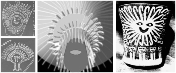
An angle of observation directly into the current above the would look just like these features found on petroglyphs in New Mexico…

Or on 1st and 2nd century A.D. Celtic coins…

On the layout of hundreds of wood and stone henges @2300-2800BC…

Also the head of Gitchi Manitou is almost certainly Venus once you examine historical and mythological references. The waves in form would be caused by the interaction with heliospheric sheets, magnetospheric distortions etc. It also possesses some of squatterman’s features.
https://albinger.files.wordpress.com/2015/06/gitchi-manitou.jpg?w=204&h=300
Mesopotamian 2nd millennium BC

Same feature at Serpent Mounds Ohio…

If you are curious just let me know by email.
~Edward
Nearly forgot…
“My post connects the images to the traditional pre-European-contact Algonquin bands that would have gathered on an annual basis in the Stony Lake area not far away from the out-of-the way site. If you “believe (you) know precisely what they (the images and their meanings) are with the possible exception of 3 globally recurring glyphs”, it would seem that my post missed the mark with the evidence it provided.”
It did not in the least.
I am actually completely on board with your post. I am just telling you that almost without exception they were faithfully recording what they saw in the sky as were the Sumerians, Naqadans, Australian aborigines, numerous European neolithic populations up to and including renaissance painters.
I never said anything about them having any MEANING what I said was…
“… I believe I know precisely what they are with the possible exception of 3 globally recurring glyphs.”
I stand by that statement.
In fact there is NO meaning to them other than that they were likely celestial observations recorded by indigenous populations at specific times all around the world when the earth’s atmosphere started producing high levels of 10Be and C14 radionuclides which would be consistent with either a geomagnetic field strength reduction of massive proportions, asteroid strike, GCRs from a supernova somewhere close in the galactic neighborhood or a massive solar storm event(s).
BTW… Dewdney was right on his Lascaux hunch and I can prove it.
As before just email me if you are interested in understanding an alternative theory to what others may believe the origin of these glyphs to be.
Pingback: The Peterborough Petroglyphs: Building Over An Ancient Algonquian Ritual Site – Kærry Redwood Atjecoutay
Hello all. I literally stumbled upon this site. I visited there a few years ago. Unfortunately, I was not able to stay long while viewing the petroglyphs as I had an immediate nervous breakdown, crying and shaking. No known reason, and I am not normally an emotional or outwardly spiritual person. If this is a common thing or uncommon Id love to hear from you. Don’t hesitate to contact me with your theory.
Andrea, more to the point would be your take on it. You know yourself and your story best and what was going on at the time of your visit.
Perhaps now would be a good time for you to return to the site and, with you additional years of life experience and understanding, take it all in again.
If you can, combine it with a trip to Bon Echo Park to see the Mazinaw pictographs. Having your own canoe and a fellow paddler would make it even better.
“Not clear is what makes the petroglyphs pop out as they do.” I know for a fact that researchers used black crayon in order to see the images more clearly . cheers
Stephen, I was commenting about the image with the coloured-in petroglyphs. It comes from a 1962 news article and thus is a few years before the Vastokas team began their work on the site. I wonder if someone had already “coloured in” the images or if it was just dirt. Later the cavities werre indeed coloured in with crayon by Vastokas; the appropriateness of doing so is debatable.
Pingback: Cochno Compared « Western Geomancy
The Haundenosaunee are “more advanced” than the Algonquin because they were agricultural? Get your Eurocentric notions of progress out of our knowledges
It may have been best for you to stop reading! There would surely have been yet more disturbing material for you to deal with.
What you dismiss as “Eurocentric’ I find very persuasive and useful in my attempt to understand things. Next, you’ll be writing to Sid Meier to complain about his computer game Civilization since it makes use of the same concept.
The writings and research of Marvin Harris, Jared Diamond – and, I guess, going all the way back to Tyler and Morgan – develop the basic notion of cultural evolution. What is primary is economics; Harris calls his approach “cultural materialsm”. There is no suggestion in Harris or Diamond or in the more recent work of Johnson and Earle of the moral inferiority of forager cultures as opposed to agricultural or industrial ones. We’re talking economics – and, in the case of Diamond, the good luck of being in a great geographical location.
Not that you have any appetite for more information on the topic, but here is a google link to a couple of chapters of the Johnson and Earle study (published in 2000) that continues to make use of the same basic construct of the development of more complex cultures from hunter-gathering (i.e. foraging) to agricultural – The Evolution of Human Societies: From Foraging Group to Agrarian State –
https://books.google.ca/books?id=YQh84b1rF-AC&pg=PA41&source=gbs_toc_r&cad=4#v=onepage&q&f=false
I am left wondering what “knowledges” you are referring to? I’ll also admit that the “s” at the end of the word has me puzzled. Just a typo? If not, what are you talking about?
You refer to it as “our knowledges”. However, given that the stories and explanations and myths and observations of nature were the product of (and meant for) a pre-European contact economy that was shattered with the introduction of a fur trade economy 300 years ago and the later development of a wage economy in the 1800’s, how relevant can “our knowledges” still be to most Anishinaabe living their lives in 2018.
Actually, it IS a very Eurocentric (meaning biased toward a solpisist and linear view of society) perspective. For all the technology white people STILL, as a collective, haven’t figured out the basic fundamentals of human decency toward each other or this planet and its other inhabitants never mind indigenous peoples.
The Eurocentric view still in operation today that you reference in the google link is based on EB Tylor’s concept of “civilization” which in turn is based on the Greeks’ “great chain of being” which are both reductionist and based in a notion of western exceptionalism, and extremely linear (as though actual reality is linear!!!!!!!)…both very outdated perspectives in the international anthropological community. For every legitimate scholar there are 100 more who are polluting research with their biases.
The western world measures “advanced societies” by technology first, social developments last. The end result? Socially primitive, violent, ethnocentric and culturally chauvenistic communities who think capitalism is still a good idea lol.
The ironic thing about your post-modernist worldview is that it too is a product of that civilization you dismiss as Eurocentric. For someone arguing against any grand theory of anything, you certainly have a very “strong” (I’d say racist) lens through which you take in and organize your notion of reality. To my mind, it is way more offensive than the view that the Maya or the Inca – or the Iroquois – were more economically advanced than the Algonquin.
As you wrote somewhere else online a few years ago –
Clearly, you have your own grand theory which explains everything to your satisfaction. It would seem that the only thing that has changed for you in the past five years is a shift from hahahahaha to lol.
Hello,
Petroglyph parks is quite unknown in Quebec. Even university teachers appreciative of Firsts Nations do not know this site (I personally discussed with 2 known specialists one an archeologist and a respected historian did not know of it). I visited the site twice with 2 Phd in history. Is it possible to use one of the picture representing the native women in a book to be published in French? To who can I contact to have a permission to use one of these 2 pictures? Thank you!
Jean Claude, C’est vraiment un site incroyable, n’est-ce pas! I only got to it in my 64th year and I live in Toronto! With respect to the photo, I am not sure which one you mean. Since those in charge of the park no longer allow photographs of the rock face and the petroglyphs, I did not take any. The images I did insert in my post were either from Government of Canada web sites or from the following website –
http://www.jwwerner.com/history/PETROGLYPHS.html
If one of the images from that site is what you are thinking of, you might send them an email asking for permisssion to use it.
The two photos I included of drawings of sections of the site were of an information board at the entrance of the building. The guide was good enough to take it outside and let me photograph it! It may come from the difficult-to-find Vastokas book Sacred Art of the Algonkians. You might get in contact with Joan Vastokas at Trent University’s Department of Anthropology. Perhaps she may have an appropriate image she would allow you to make use of?
Bonne chance avec tes recherches!
You might be interested to know that Norval Morrisseau likely visited what is now Petroglyph Provincial Park near Peterborough around 1960, which was after its discovery in 1954. Some of his 1960 birch bark paintings match the petroglyphs, but his earlier birch bark pieces do not.
Bob, it has been a while since I did some research on Morrisseau and his development as an artist. if you’re interested, the post is here complete with lots of images, maybe even one or two of the ones you are thinking of –
From what I can recall from my reading, Morrisseau didn’t get to southern Ontario until 1962 for his art show at the Pollock Gallery in Toronto. He may well have visited the petroglyphs at that time though none of the material I have read make any mention of this.
A more likely explanation of any similarities with the Peterboro petroglyph style might be his access to the sketches that Selwyn Dewdney did of the site and which he quite probably shared with Norval. Dewdney was at the Mazinaw pictograph site in 1959 and also mentions the petroglyph site in the first edition of his book.
The two spent some time together with Norval and his family even staying with the Dewdneys in London for a while. Morrisseau was a keen student who poured through books of indigenous art from across North America even in his Cochenour/Red Lake days in the late 1950’s. He took his Ojibwe heritage and his grandfather’s stories and a mix of other influences and crearted something unique – the Picasso of the North indeed!
Hi
Great site and perceptive slant on the presumptive Native hi jacking of a Canadian resource that should be available to all – without the ‘spiritual’ bullying like ‘no picture taking’. Why has the Parks toadied to the native demands?
Pingback: Petroglyphs provincial park – 歆远看世界
Reblogged this on NEW Sparta.
I first heard about the site from my teacher Paul Sweetman who did the original report, I think it was in 1955 he published it. My girlfriends and I as Stoney Lake teenagers in the ’60’s tried to find it to no avail. He was sad nothing had been done after his report. It was nice to visit later and find it was being preserved.
Trudi, Paul Sweetman seems to have lived a full life working at things he loved to do. I googled his name and came up with this summary of his life – https://canadianarchaeology.com/caa/about/awards/recipients/margaret-and-james-f-pendergast-award/paul-sweetman
Your 1955 date sounds right since he first visited the site in July 1954.
While some have complained about the structure that protects the rock face, I do have to wonder what they would have suggested instead! Nice that you eventually found your way to the site! I had only the vaguest notion about this cultural treasure until about ten years ago. I’m glad I found my way to it!
OK, I promised some time ago that my book of my search for ancient wisdom found in pictographs and petroglyphs was coming out. I’ve learned now that publishing in Canada takes time. I also had to give time, time to act in telling the story properly. Prior to even starting I had to wait for some form of permission. The book will be coming out hopefully in June from Friesen Press. It is now called Chasing the Muse: Canada.
The first part of my story gives my credentials, motivation, and actions to be able to approach what was said at the time, “unknowable” The second part is my odyssey to cross into another dimension of experience and learning, often very funny, often very moving, often dangerous. I do experience a ceremony on the rock so profound, that there is NO doubt that what I was being taught about the Teaching Rocks was REAL. My story goes on to tell of the rewards and consequences of my experience. ( I include roughly 150 photographs to prove my stories actually happened.)
I have a very good feeling about this book. I just told my story this week to a sell-out crowd in Ottawa with 80 turned away. ( Among other institutions I have spoken about it is UCLA)
Chasing the Muse: Canada, an often funny often moving, often dangerous odyssey in search of Canadian history, identity and landscape, will be available on Amazon. I can’t get a specific release date yet from the publisher. I do guarantee that it will be a fun read. I wish I could post the clever cover here.
Lloyd Walton
Lloyd, fantastic to hear you got ‘er dun! I look forward to picking up a copy. It sounds like the boreal forest version of Castenada’s The Teachings of Don Juan! If it comes out early enough in June it will come along as nighttime reading as my bro and I paddle down the French River, a very scenic stretch of the epic trans-Anishinaabe water highway, the Trans-Canada of its day!
Hi
What is your name? (I did not read the endless material on the site. I am a slow reader! I also get irritated easily.)
I am Hans Martin.
–I have visited the Peterborough site about 15 times (guess) since 1982, I guess.
–Since youth I have studied Native American cultures, – I’m 82.
–I have visited about 75 sites globally. I guess.
–Have a huge collection of notes, photos and slides.
–My mentor was Jan Cameron, B.C.
Peterborough is a much talked/speculated about and misunderstood site. The building has destroyed its ‘meaning’. I told Ian Wainwright (Canadian Conservation Institute) that when he was advising on its construction.
The site is a direct bond between the Native community and the universe. No local cuddly stuff here. This is serious. The site confirms each year that the ‘spirit’ is still in control and that is good if you do not know how things work.
There is a second site. Had to be, intuitively. The site gives guidance to the second site, mentioned somewhere. I found it, the second site. The area of interest is about 600 meters square with reference to a much larger area. I did not measure it but have surveyed local things with a professional theodolite.
I have consulted with the Smithsonian Institute on one occasion, with wonderful results. Also, have worked and had contacts/visits with folks in the USA, Norway, Sweden, Germany, Italy, Mexico, Finland, etc.
I am an atmospheric physicist, Ph.D.
Erstwhile director: Gov. Can. Air Research labs
Retired Science Attache, Can. Embassy, Germany
Hans, nice to hear from someone who shares an interest in Anishinaabe pictographs and petroglyphs. Given the details you provide, it sounds like it has been a lifelong passion. I make no such claims! It was only in 2013 that I really took notice and began to visit pictograph sites on our canoe trips and try to explore their possible meaning.
What is your name? (I did not read the endless material on the site. I am a slow reader! I also get irritated easily.)
See my About page for some background. Re: “endless material”. I prefer the sound of “extensive” as it sounds more positive! Sorry to hear about your irritability! Maybe read in smaller bits?
Peterborough is a much talked/speculated about and misunderstood site. The building has destroyed its ‘meaning’. I told Ian Wainwright (Canadian Conservation Institute) that when he was advising on its construction.
I don’t share your view that the building destroyed its meaning. I think time itself has done that in two ways. Firstly, due to the erosion of the stone and the gradual disappearance of more and more of the carved images; secondly, due to the fact that the people who created the images are long gone and the First Nation which now is the “caretaker” of the site has created another meaning for the site, a meaning more in tune with life as they know it now.
The site is a direct bond between the Native community and the universe. No local cuddly stuff here. This is serious. The site confirms each year that the ‘spirit’ is still in control and that is good if you do not know how things work.
I must be more hard-headed than you! You say “no local cuddly stuff” but then go cosmic cuddly instead! While I understand the satisfaction of connecting our human lives with the cosmos, in the end, I see it as the product of our imaginations and not objective reality. There has always been a role for fantasy-prone individuals in any society; they tell great stories and provide the other members of the group with a sense of meaning and purpose. From my cultural materialist perspective, that is how things work. You can, of course, continue to be comforted by your belief that the “spirit” is “in control and that is good”.
There is a second site. Had to be, intuitively. The site gives guidance to the second site, mentioned somewhere. I found it, the second site. The area of interest is about 600 meters square with reference to a much larger area. I did not measure it but have surveyed local things with a professional theodolite.
The government report from the early 1970s mentions that other site. It does not sound as extensive as you suggest it is. I would guess that if it was really significant they would make an effort to protect it and perhaps include it in a visit to the petroglyph site.
In any case, thanks again for your comment. I do wish you continued energy to explore our shared interest from your perspective!
Tschüss!
Hello Hans. Sorry that you are a slow reader but I did write a book about my 16-year odyssey to make a very serious film about the Peterborough petroglyphs and where it was. In the first third of the book, I give my credentials to tell the story.
As you probably know, they were called the Teaching Rocks which was the name of the film. When I was on the rock with the elders they talked about the other site that you mentioned, and where it was located.
A comment about my film from J.V. Wright, curator of Ontario Archaeology, Archaeological Survey of Canada. He wrote to the Ontario Minister of Natural Resources:
There is more insight as to the carvings in my book CHASING THE MUSE: CANADA available on Amazon Kindle books,
Lloyd, I am glad you chimed in! You actually crossed my mind as I was typing my response to Hans. I am sure he would enjoy reading Chasing The Muse. Your perspective on the pictographs – and on the mystical nature of life in general – is something he will totally understand and which your book provides many examples of.
On the other hand, I knew it might be a difficult ride when I saw that the book was dedicated to Fred Wheatley – but I did read the first 2/3s of it. I will say that it definitely gave me a better sense of where you’re coming from – and how you got there! It is just not a perspective that my life has led me to. I hope all is well with you up there in the north country! BTW I like that painting of the goalie in the background and the hockey stick blades in the foreground – nice perspective!
I got Chasing The Muse from the Toronto Public Libary after a one-month wait. Given that there is a Kindle version, I may just download it and read the rest!
Lloyd Walton’s book Chasing The Muse can be found at Amazon. A click on the following link will get you there!
I wasn’t sure what your reference to Fred Wheatley meant but as an Ojibway language professor, and lifelong researcher of Ojibway speakers over much of North America as Fred did, I felt that my many references of the language being a “picture language” would help readers make their own conclusions about how the images were interpreted to me directly.
Readers have told me that in the second reading, it becomes a different book. As to the spiritual aspects of the book, the last chapter deals with an incident with an eagle at a certain spot at a certain time of day at Thanksgiving. By coincidence, I had a deja vu this Thanksgiving while in the same spot where the incident happened in my canoe with the same light. I looked up and two eagles flew across the sky. Other incidences more profound occurred of which I cannot write.
Reading the official descriptions and archeological analysis of the site at the beginning of this subject and the cursory analysis of my film raised my eyebrows, to say the least.
It was NOT discovered in 1954!!!!! I met several elders including the Chief of Curve Lake, Aubrey Copoway, who told me stories of finding it and covering it back up.
Someone challenged the notion in my film that” we must warn the white man before he poisons the whole earth. ” I have had that section in the rock read to me and can prove that assertion.
Someone also mentioned to disregard adjacent images to each other. they DO relate to each other. The rock is history, prophesy and, methods for having a good life. The so-called “Sun God” is one of them. I had a 2 1/2 hour lecture about the meanings in that figure, the Path to a Good Life. .
you can read Vastokas book here-
https://archive.org/details/sacredartofalgon0000vast
Anon – Thanks for the reminder!
I had just googled my way into the archive.org site last week and found it there. I did borrow the book for an hour and ended up getting screenshots of the various pages of Chapter IV: The Meaning of the Glyphs. I wish I had read the material years ago before I wrote most of the post.
I did insert one quote from that chapter into the post – the one where the snake glyph is loosely connected to the “serpent mound” down on Rice Lake.
I will update the post and point out the availability of the digital copy of the book to interested readers. Thanks for the prompt!
Hi
I have a copy of the whole book you can download from here –
Click to access Sacred%20Art%20of%20the%20Algonkians%20-%20Vastokas.pdf
The 3rd time I visited the site was in 1999 with the specific purpose of debunking the Viking theory. You can read about it here – https://www.iancmacfarlane.com/kawarthas-orig/petroglyphs_BFviking_1.htm
Cheers
Ian
Ian, much appreciated! I’ll upload it to my iPad for leisure time or rainy day reading during our next canoe trip! Re: the Viking hoax – it just refuses to die! No amount of evidence will persuade a committed believer!
See the Recent Comments section on the right-hand side of the page for my back and forth with an enthusiast of the Vikings in Lake Superior story. It is not for nothing that the Minnesota NFL football team is called the Vikings!
The Teaching Rocks 1987 by Lloyd Walton and Sacred Places: The Teaching Rocks (just shows the petroglyphs with music)
Thanks for that! Uploaded in April of this year – wasn’t there the last time I looked! I’ve embedded it in the post.
I have remastered my film and it will be put on YouTube soon. What happens to this one?
Lloyd, were you the one who uploaded it to Youtube? If so, thanks. It is great to have a copy out there for people to see.
Re: this one if a remastered one is available…I’d delete this embedded one and provide a link to the remastered one, of course. The sound on this one is for some reason a bit echo-y and occasionally unclear.
I have no idea who put that on or how to take it off.