
Table of Contents:
- The Route Map
- Getting To Oshawa – The GO Train
- Down To the Waterfront Trail
- Along The Waterfront To Highland Creek
- From Highland Creek To Ellesmere Road
- West On The Meadoway
- The East Don Trail/Mocassin Trail/Don Trail to Danforth-Riverdale
- Metrolinx Construction On the Lower Don Trail
- Options From Pottery Road
—————
The Map of The Off-Road Route
These days, I find myself looking for off-road bike routes as much as possible. While I have been cycling in the GTA for the past fifty years, the on-street experience is not what it used to be! The recent addition of electric motorcycles and scooters just adds to the potential stress. Luckily, a Toronto-area cyclist has options available. This post describes a recent bike ride which combined
- a train ride from the Danforth Go Station to Oshawa Go Station
- a string of off-road trails which make up 85%+ of the day’s return-home ride
Click here or on the map image below to access my Ride With GPS page and, if interested, to download a file of the route for your Garmin device or iPhone.

Route Overview – Oshawa to Toronto East End (Riverdale)
After arriving at the Oshawa Go Station, I spent the next five hours in tourist mode, making my way back to Toronto’s Riverdale neighbourhood just south of the Danforth. Here are the trails I cycled and their approximate lengths –
- Waterfront Trail – 36 km
- Highland Creek Trail – 4.5 km
- Morningside Park Trail – 2 km
- The Meadoway Trail (formerly the Gatineau Corridor Trail) – 12 km
- East Don Trail – 2 km
- Moccasin Park Trail – 2 km
- Don Mills Rail Trail – 1 km
- Lower Don Trail – 6.5 km

Screenshot
The Great Lakes Waterfront Trail website is a goldmine of mostly off-road cycling possibilities from Sault Ste. Marie all the way to the Quebec border and La Route Verte, Quebec’s cycling trail
See the map sets below for PDF files of the two sections that apply to my bike route.
At Highland Creek, I left the Waterfront Trail and headed up the Highland Creek Trail. You could just continue on the Waterfront Trail to the Toronto harbourfront area and beyond.
—————
Getting to Oshawa – The GO Train
Hopping on the Go Train at the Danforth/Main Station eliminated some tiresome heavy traffic, especially along Kingston Road, and had me at the Oshawa GO station in 50 minutes.
At Danforth Station, you need to get over to Tracks 2/3 via the underground passage. There are stairs, but I took the elevator down and then, after a short walk, back up to the eastbound tracks.

Trains every 30 minutes starting at 6 a.m.
The GO Train experience is hassle-free, and bicycles are encouraged. Most cars have a spot designated for bicycles and both ends of the car. The occasional car has a red no bicycle sticker on the side of the car

At the Oshawa GO Station, once you are on the platform, the exit is at the east end. After tapping out on your cell phone’s Presto app, head across the mall-sized parking lot to get to Bloor Street. The adventure is about to begin!
From Union Station, the ride to Oshawa Go takes a bit over an hour. I got on at The Danforth GO Station because of its convenience and absence of the hubbub of Union. I you find yourself doing the route this post details, take a look at this video on your way there. It provides a critical look at the GO Train system and the massive parking lots you will glimpse as you stop at the various stations en route.

—————
Down to the Waterfront Trail

You won’t be seeing much of Oshawa. The Go Station is located in the southeast corner of the city in an industrial zone. Just to the east of the Go Station is the General Motors manufacturing complex, the engine of Oshawa’s economy for the past 120 years. Unfortunately, its glory days are in the past

Oshawa GO – Bloor/Victoria – Thickson
About two minutes into the ride, Bloor Street becomes Victoria and you are now in Whitby! Then it is a left-hand turn down Thickson Road to access the Waterfront Trail.
The traffic on Bloor/Victoria is mostly from vehicles coming from or going to the GO parking lot. Once on Thickson, the first stretch is somewhat busy; the bottom half is all but free of traffic. The traffic on the first 2.5 kilometres of the route is about the most you will see all day!

The Waterfront Trail heads west from the bottom of Thickson Road in Whitby
It was only after the trip, while examining the Waterfront Trail map more closely, that I noticed how close I was to the Camp X location on the boundary between Whitby and Oshawa. It was here that a wartime school to train secret agents in the arts of clandestine operations once stood. [The buildings were removed in 1969.]
The area is known today as Intrepid Park, after the code name for Sir William Stephenson, Director of British Security Co-ordination (BSC), who established the program to create the training facility. [source]

Wikipedia article source for the above information
—————
Along The Waterfront to Highland Creek

Oshawa Go Station to Waterfront Trail in Ajax

Waterfront Trail – Ajax to Highland Creek

Curious about the four cities/towns I would be cycling through on my way back to Toronto, I googled my way to this map, which shows their sizes and boundaries.

Over the past fifty years, these towns have experienced significant growth as bedroom communities, offering more affordable housing for people working in Toronto. As the YouTube video above notes, the GO Train network provides these suburban communities with massive parking lots where they can leave their vehicles for free all day while they commute to downtown Toronto.
2021 population figures sourced from Wikipedia were roughly –
[Click on the town/city name to access a Wikipedia entry on its history and economy.]
The development has occurred almost entirely north of the 401, leaving the waterfront area for a mix of parkland, marinas, industrial plants and warehouses, thanks to its proximity to the 401 highway and the CN rail line.


a subdivision on the west side of Whitby Harbour

I had the trail mostly to myself on this weekday morning, sharing it with the occasional jogger, dog walker, and fellow cyclist. Mature tree cover and the proximity to the lake made it feel cooler than the official 28º.

Ignoring the “Sidewalk closed” sign in the image above, I cycled into my first trail blockage! Perhaps on my next visit, they will have gotten around to putting that blue line on what looks like it will become the new route. It looks like a major building is going in the area surrounded by the chain link fence.


a stretch of the trail alongside Victoria Road in Whitby
The off-road trail continues through the Lynde Shores Conservation Area. This section of the trail was opened and made a part of the Waterfront Trail just a decade ago.

entering the Lynde Shores Conservation area – bridge coming up
Another brief stretch of on-road going down a very quiet Halls Road…and then it is back to the off-road trail

Looking up Halls Road from the south end
From the south end of Halls Road, the off-road trail continues, as seen in the image below.


Once across Lake Ridge Road South, you have left Whitby and are now in Ajax! Then it is on to the Pickering waterfront and Frenchman’s Bay. On the bay’s east side is the Pickering Nuclear Generating Station, around which the Trail heads. Little of the nuclear plant is visible until you get to the Beachfront Park boardwalk.
The Pickering Plant is one of three Ontario nuclear generating stations – the others are the Bruce and the Darlington plants. The Pickering station is the oldest, which would explain why four of its eight reactors were shut down permanently in 2024. The other four are apparently going to be retired at the end of 2026. Along with Bruce and Darlington, it provides Ontario with 60% of its electrical energy.

The Waterfront Trail around Frenchman’s Bay in Pickering
Here is the official Waterfront Trail map of the same section of trail –

See here for the complete set of Pickering to Oshawa to Port Hope set of Waterfront maps.
It had been a couple of years since I cycled this section of the Waterfront Trail. When I did, the boardwalk had not yet been constructed, and I remember pushing my bike over the soft beach sand to get to the west end.

looking west at the Pickering Beachfront Park Promenade – walkway and bikeway

the west end of the Pickering beach promenade
A potential rest stop and cup of coffee are possible on Liverpool Road as you make your way up and around Frenchman’s Bay. After a brief pause in the shade by Millennium Square, I moved on, knowing I had an extra water bottle and a snack in my bike bag.

Liverpool Road and the Pickering waterfront at Frenchman’s Bay
Up Liverpool Road to Radom Street and then a turn left to the Waterfront Trail’s continuation – or turn left at Annland Street for a quieter route up to Radom. For a little under a kilometre, the Trail follows Bayly Road before turning south and skirting the edge of a residential subdivision.

A view of the Pickering reactor from the west
I found a shady spot a couple of kilometres further on and stopped for a break. To the east side of Frenchman’s Bay, the nuclear plant’s multiple reactors, four of which have been retired. The remaining four – known collectively as Pickering B – have had their lives extended to the end of 2026.
![]()
The next major landmark on the Waterfront Trail is the pedestrian bridge across the mouth of the Rouge River. The Rouge forms the boundary between Pickering and the City of Toronto.

Cross the bridge and you are in the district. of Scarborough. It was one of the six boroughs which made up Toronto pre-amalgamation in 1997. Drake’s naming Toronto as The Six is said to refer to the six boroughs. Toronto’s area code 416 provides yet another connection. Drake himself grew up in the Forest Hills neighbourhood in “Old Toronto”.

Looking west from the bridge across the mouth of the Rouge River

Rouge River mouth with CN rail bridge and Waterfront Trail Bridge
The Rouge River pedestrian bridge was completed in 2012 and connected the trail from Highalnd Creek to the one coming east from Pickering.

A view of the mouth of the Rouge from the west side
The next landmark on the Waterfront Trail is the Rouge Hill GO Station. There is an entrance right off the trail to the eastbound tracks. Bicyclists coming from the west can debark the train and head right onto the Trail. One complication – there is no terminal to tap off on the eastbound side, so you have to go to the other side to do so.

a satellite view of Rouge Hill Go Station and the Waterfront Trail

the east end of the bridge over Highland Creek on the Waterfront Trail

looking east on The Waterfront Trail bridge over Highland Creek
—————
From Highland Creek To Ellesmere Road


Trail detour heading north on Highland Creek Trail

—————
West On The Meadoway
(also referred to as the Gatineau Corridor Trail)
Morningide Road leads into a short (less than a kilometre) gravel section of trail (the Upper Highland Creek Trail). Ellesmere Road is the next landmark, and an underpass takes you to the north side and the Meadoway Trail.

What follows is about 10 kilometres of off-road trail and a couple of on-road connecting sections that take you from east of Scarborough Golf Club Road to Victoria Park Avenue, the western boundary of the former borough of Scarborough. The bike trail makes use of the hydro corridor that exists to deliver electricity from the two nuclear plants further east at Pickering and Darlington.

There are a few streets to cross, some minor ones with no traffic and a couple that are busier and require some caution or a green light. Following a GPS track on your cellphone definitely makes it easier to negotiate the occasional zigs and zags of the route through residential neighbourhoods. The stretch from Brimley to the LRT overpass just before Kennedy is the longest of the residential connectors.

Curious about where the Meadoway ended, I followed it to its current endpoint at Eglinton. Then I turned around on the trail and headed back to Victoria Park to access Elverston Drive. It leads right into the East Don Trail, a short but enchanting stretch of bike trail through a mature forest whose shade provided some relief from the noonday sun.

The sign below has three different names for the trail. I guess they haven’t gotten around to putting up the name I assume is the current one – i.e. The Meadoway.

The Path With Many Names!
—————
The East Don Trail To The Danforth & Riverdale

entering the East Don Trail from the east


Screenshot
After cycling the last bit of the Meadoway Trail down to Eglinton, I turned around and returned to Victoria Park Avenue and headed north to access Elverston Drive. It leads right into the East Don Trail, a wonderful stretch of bike trail through a mature forest whose shade provided some relief from the noonday sun.

The East Don Trail also features a couple of underpasses and a bridge over the East Don. The bridge over the river leads to a railroad underpass, one whose western face I have noticed countless times while driving up the Don Valley Parkway. What is there currently is only a shabby remnant of the whimsical entry to a magical world.

The second underpass is more substantial; it takes you under the Don Valley Expressway to the beginning of the Mocassin Trail. Some climbing will be required as you pedal your way up the west slopes of the river valley!

The Moccasin Trail leads into the Don Mill Rail Trail (also referred to as the Leaside Spur Trail). It heads 900 meters south to an awkward exit on the right via a sidewalk that leads to Leslie Street. A short ride down the hill on Leslie and a right-hand turn, and I was on the Don Trail, which took me all the way down to Pottery Road.
This part of the ride I have done hundreds of times over the years, and it never grows old. There is change afoot in the neighbourhood, however!
—————
Construction On the Lower Don Trail

Looking south from the Leaside Bridge – the bike path runs diagonally from bottom left to the right. The Police Dog Training Facility is in the woods, and Pottery Road is a bit further.
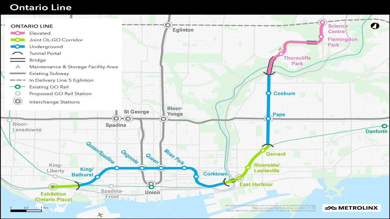
On the way down to Pottery Road, I passed two major construction sites. The bridges marked in black above Cosburn on the Metrolinx map below are what you will see them working on these days. They are two components of the Ontario Line, a massive $27 billion (and counting) project that will provide Toronto with another transit line. The Ontario Line will run from Exhibition Place to the old Science Centre location.
[See here for a map of the entire line and the accompanying legend. The red line indicates elevated tracks and the blue underground.

Metrolinx Ontario Line – map source
The Wikipedia article on the Ontario Line notes the changes in
- the projected completion date and
- the overall cost of the project
since it was announced in mid-2019, five years ago.
In July 2019, the estimated completion date was 2027. By December 2020, the completion date had been revised to 2030. Metrolinx said that the original completion date was based on market conditions that since 2019 had changed dramatically.[41] By November 2022, the completion date was being reported as 2031.[5]
In 2019, the estimated design and construction cost of the line was expected to be $10.9 billion. By November 2022, that estimate had nearly doubled to $17 to 19 billion, including not only design and construction but also financing costs, operation, and maintenance. The provincial government claimed that the higher estimate was due to inflation and supply issues.[5] Wikipedia article source
In the end, given that it is another Metrolinx project, we will just have to accept that “it will take as long as it will take”.
—————
Route Options From Pottery Road
I headed up Pottery Road to Broadview and made my way down to the Rooster Coffeehouse for a celebratory cup of coffee. I spent about five hours on the 75 km ride and had a great time doing it. I look forward to doing it again in October, when the fall colours will add another layer of magic to the route.
——

Pottery Road – to Broadview, to the Bayview Bike Path, and the Ravine Beltline
From Pottery Road, there are other route options available:
from Pottery Road south on the Bayview Bike Trail
The Bayview Bike path runs adjacent to the roadway and goes right down to Front Street or Mill Street. Just a couple of streets west is Cherry Street. Turn left to access it, and you are right back on the Waterfront Trail – aka the Martin Goodman Trail.
from Pottery Road over to the Brickworks to access the Beltline for uptown locations
It is a bit of a climb up the Beltline Ravine Trail, but soon you are on St. Clair, having cycled up one of Toronto’s most beautiful slices of forested ravine.