
Table of Contents:
- Day 2 Basic Data and Maps
- First Up – The Dalles Rapids Portage
- Woolford’s Early 1820s Painting of Dalles Rapids
- Tramway Point
- A Walk Up The Side of the Rapids
- On To Little Dalles Rapids and Passing Camp McIntosh
- French River Village Site – Some History
- Checking Out the Sawmill Remains
- The Location of French River Village
- Historical Images of French River Village
- TV Ontario Mini-Doc: “The Ghost Town of French River Village”
- Shortest Way To the Bustards – Cantin Point To Coral Channel
- The Coral Channel
- Safe Harbour By Highland Home
- Our Bustards Campsite
Previous Post: Day 1 – Hartley Bay Marina to The Elbow
Canoeing Georgian Bay’s French River Delta: Logistics, Maps, & Day 1
—————
Day 2 Basic Data and Maps
- distance: 13.7 km
- time: 9:00 a.m.; finish 2:25 p.m.
- portages/rapids: 1
- P18 – 240m Dalles Rapids
- weather: sunny and hot; some SW wind; overnight rain showers;
- campsite: CS 900 (old #735) on the Bustard Islands; multiple 2- or 4-person tents


—————
First Up – The Dalles Rapids Portage
It had rained a bit overnight and the tarp was wet when we crawled out of the tent around 6:45 along with the just-appearing sun. However, the tarp had done its job and the fly and tent were dry as we stuffed everything back into their compression sacs for the day. By 9 we were finally on the water, having dallied a bit in the early morning sunshine with our cups of coffee on the flat rock point to the side of the campsite.
This day would involve a bit of history, the part of the French River story dealing with lumbering and fishing. Just 1 kilometre down from CS 672 (old #624) was the only portage of the day, a 240-meter carry around Dalles Rapids.

French River Main Channel Dalles Rapids and Portage
As we neared the rapids we came upon the rusting boiler of one of the tugboats that used to pull the log booms downriver to the rapids and towards the sawmills of French River Village another kilometer or so downriver.
In the image below you can see a canoe and the portage sign to the right of the boiler which gives the point its current name.

alligator boat boiler from the lumber era on river left of the French River’s Main Outlet
—————
Woolford’s Early 1820s Painting of The Rapids
And then the Dalles Rapids. In my thoughts was a painting of the chute done by the English landscape painter John Elliott Woolford in the early 1820s. He was travelling down the river with the then-Governor-General of the British North American colonies, the Earl of Dalhousie. This was sixty years before the main outlet of the French became the route where the logs were floated down from upriver. Given his watercolour, it promised to be a dramatic sight!

John Elliott Woolford. Rapid of La Dalle, French River, Ontario.
Well, there was some artistic license taken by Woolford! Our first look at the rapids from above did not match his painted view. The use of the name “La Dalle” is also confusing since the name La Dalle refers to the final set of swifts on what is now the Old Voyageur Channel further to the west.
We’d get a closer look at the rapids from the bottom after our 240-meter carry over a well-used path on river left around the Rapids.

—————
Tramway Point
Wondering about the origins of the name Tramway Point, I found a passage in Toni Harting’s book which provided an explanation. The Tramway Point label on the map above should be on the same side of the river as the portage. Harting writes –
In about 1907, a narrow-gauge tramway was constructed south of Dalles Rapids (roughly following the still existing fur-trade portage trail connection Boiler Point Bay to Dalles Pool) to transport all the material for the Canadian Pacific Railway bridge being built over the French river, 1 kilometer downstream from Dry Pine Bay. The logging companies used this tramway for a while to transport supplies but in the long run it did not meet their demands and was subsequently abandoned. (86)
While we did see a few remnants of this logging past, the tramway itself is not there. See here for a photo of a section of that tramway. There is more information later in this post.
—————
A Walk Up The Side of The Rapids
After an easy carry on a woodlands-like trail, we paddled upriver to the bottom of the rapids and scampered up the banks for a closer look. More confident canoe trippers with
- barrels instead of traditional canoe packs and
- maybe a spray skirt and
- with another canoe or two in their party
may well have run these rapids, mostly characterized by a high volume of water. We tend to err on the side of caution.

French River Main Channel – Dalles Rapids panorama
We spent a half-hour at Dalles Rapids, walking up toward the top and framing some images. It is definitely a scenic spot worth spending some time at.

Max heading for the top of Dalles Rapids

a view of Dalles Rapids from river left – French River Main Channel

an embedded metal spike at Dalles Rapids – a remnant of the lumber era

Screenshot
We did find an unsigned campsite (#677?) on top of the bank where we landed our canoe; it would make an excellent spot to stop for the day and would allow you to spend more time framing images at Dalles Rapids in changing light conditions. So too would some of the other ones nearby. This snippet of the Maps by Jeff map provides the locations.

river left below Dalles Rapids on the French River

an unsigned campsite below Dalles Rapids
—————
On To Little Dalles Rapids & Passing Camp McIntosh
Moving on, we saw the ripples of Little Dalles Rapids up ahead. Perhaps it is the higher water levels this year – up two feet according to the locals – but the rapids were no more than swifts. We paddled right through. On our right, we passed Camp McIntosh, a fishing resort with six rental cottages and some other buildings, including the owner’s winterized residence.

a satellite view of Camp Mcintosh on the French River’s main channel

Camp McIntosh below Dalles Rapids on the French River’s Main Channel
—————
French River Village Site – Some History
More artifacts from the heyday of the lumber era popped up along the shore as we continued downriver. We were approaching the location of French River Village, for thirty or so years (the mid-1870s to 1910) the boomtown home of 300 that included (as listed in Kas Stone’s book):
- two sawmills
- two churches
- three hotels
- a post office
- warehouses
- private residences
- stores
French River Village died a slow death after 1910 and the end of the lumber boom; the Queen’s Hotel, once the logging company bunkhouse, burned down in 1917; the post office closed in 1922 and the last person moved out in 1934. Other than the occasional rusted piece of machinery, the one substantial ruin to be seen on the site is not far from where we beached our canoe.
The site of the village is on river left (i.e. east side) of the Main Outlet just above Loading Cove. [Note: we did not know this at the time!]


The map above left is included in Kevin Callan’s write-up of a route in his A Paddler’s Guide To Killarney And The French River(2006). It shows the village on the wrong side of the Outlet. He has probably mixed up the location of the actual French River Village with the location of a planned townsite around MacDougal Bay that never happened.
Toni Harting provides this background detail –
…a townsite called Coponaning was surveyed in 1875 at the Main Outlet of the river, just below Dalles Rapids and enclosing MacDougal Bay….The town would only exist on paper. it was never actually built…(Harting, 85)

iron ring on the banks of the French River’s Main Channel
—————
Checking Out the Sawmill Remains
We beached our canoe at the point on Callan’s map indicated by “Mill site”. The image below shows the remains of a brick wall of that sawmill. From there we walked inland a bit on a rough trail looking for some evidence of the village.
In all, there are only a couple of structures to be seen:
- the collapsed wall of the sawmill that drew us in and
- a lighthouse we saw as we looked south from the plateau the trail led us to.
We did not know it at the time but we had landed a couple of hundred meters too far north of Loading Cove to get a full view of the former village site.

three-meter high brick wall – the ruins of French River Village

brick remains of one of the sawmills at the once French River Village site
Looking south from my vantage point, I expected to see a flat area where streets once ran down to the water. There is nothing to see – except for the lighthouse which still stands to the south. That should have served as a clue that we were not quite at the village site! Instead, we went away thinking that the terrain you see in the image below was where it had once stood.

looking south towards the French River Village site from near the sawmill remains
—————
The Location of French River Village
After our trip, I kept thinking about the jagged and uneven nature of the terrain that we thought the village had been built on. It just seemed to be an unlikely choice of space on which to put up all those buildings listed above. Rereading the Toni Harting book more carefully helped clarify things.
So too did zooming in a satellite view of the area just above Loading Cove. I was surprised to see buildings since we had seen nothing but the lighthouse tower from our vantage point a couple of hundred meters north!

—————
Historical Images of French River Village

Another lucky find – the book pictured above, , Capturing the French River by Wayne Kelly helped to make sense of what the village actually looked like. [The Mobi/Kindle book can be accessed at Amazon here.] The promotional blurb at the Amazon site presents the book like this:
Capturing the French River introduces a rare collection of exceptional photographs taken along the river between 1910 and 1927 by Doctors J. Ernest Rushbrook and Frank Sherman, whose lifelong friendship was based in part around their mutual love of photography, of nature, of the Canadian wilderness and of the canoe. The collection was a serendipitous discovery by author Wayne Kelly, who immediately recognized the uniqueness of these incredible images.
The CDN$7.99. downloaded copy of the book includes a hundred or so images, some of which helped me finally see what French River Village looked like in its heyday. Here are a few that you will find as you read through this worthwhile little investment!

There was an elevated tramway that came down to French River Village and Loading Cove from the sawmills. The photo above shows the south end of the tramway near Loading Cove. The carts loaded with lumber would be pulled by horses to the dock where waiting ships would take it to points south.
The images above and below show the Ontario Lumber Company’s bunkhouse. The building served for a short while as a hotel as the lumber business died.

The photo below has the lighthouse, the company store, and the workers’ recreation hall in the foreground. On the left running diagonally up the image alongside the river are the workers’ huts. At the very top right-hand side are the two churches – one Presbyterian and the other Roman Catholic.

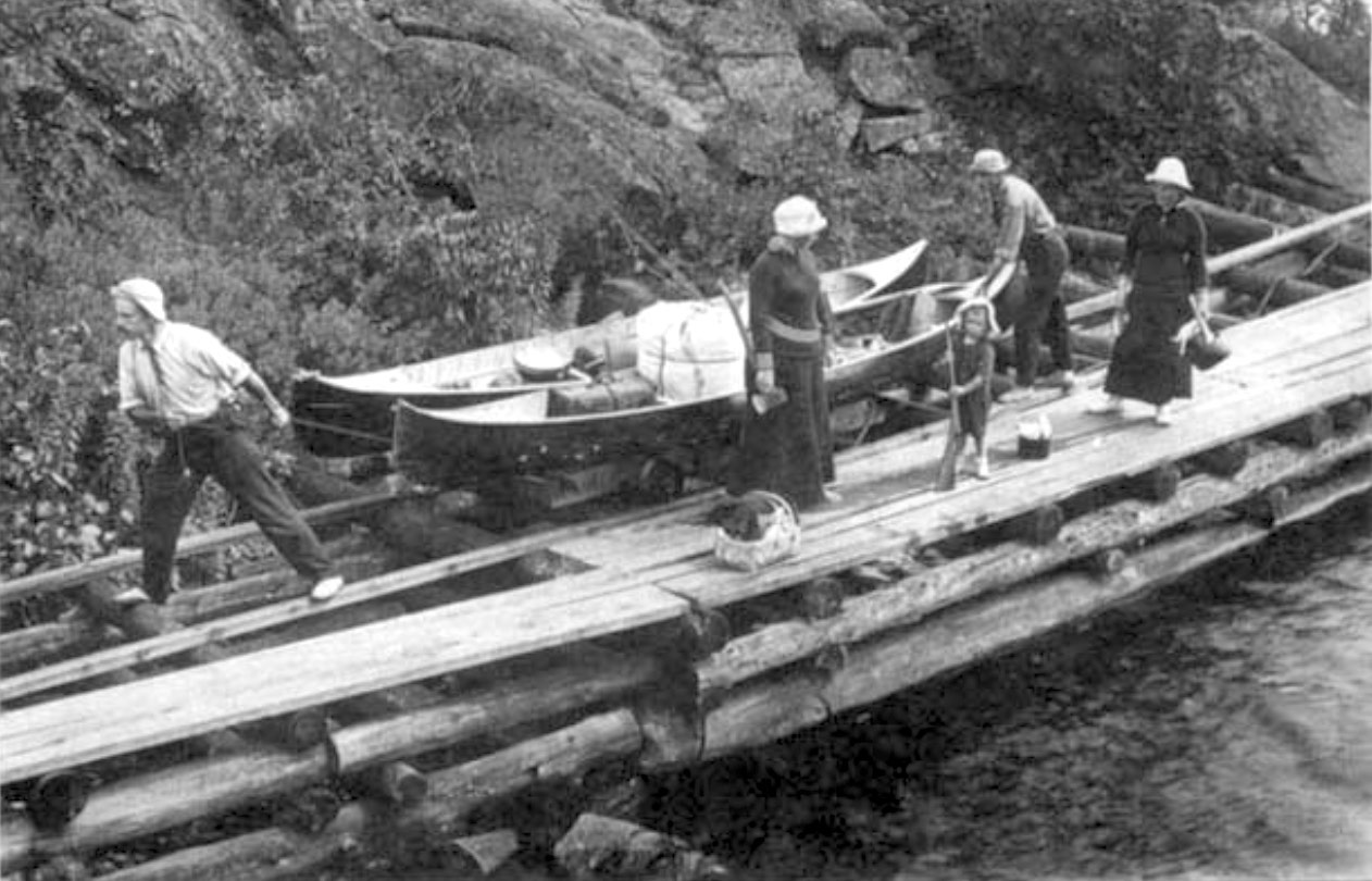
The image below shows a paddling group making use of the wooden tramway built around 1907 to haul their canoes and gear from Boiler Point to Dalles Pool. This tramway is the one described by the Toni Harting quote in the discussion of Tramway Point above.

While the village was on its deathbed by 1910, in 1917 the Ontario Lumber Company’s bunkhouse, which by then had become the Queen’s Hotel, was destroyed by a fire. That pretty much sealed the village’s fate. By 1930 most anything of value had been hauled away from the village site and made use of elsewhere in the area.

With our scan of what we thought was the former French River Village townsite done and our morning meditation on the transience of all things over, it was time to move on! We were headed for the open water of Georgian Bay!
—————
TV Ontario Mini-Doc: “The Ghost Town of French River Village”

Click here or on the image to access the video
The TV Ontario’s Tripping series Season 1 – Episode 5 has a bonus “webisode” which deals briefly (4 minutes) with F.R. Village. Paul McDougal provides some historical detail on the forty-year life of one of the many Canadian Shield towns built on resource extraction.
—————
The Shortest Way To the Bustards

We stopped for a Gatorade/energy bar break at Cantin Point. It is 2 kilometres from the Point to Tarpot Island, the northernmost of the Bustards. Subtract another kilometre for the various rocks and small islands that stretch south from Cantin Point and you are left with no more than a kilometre of open water. This is the shortest crossing route over to the Bustards. We couldn’t have had nicer conditions and in 20 minutes we were paddling into the Coral Channel between Tarpot Island and Tie Island.
—————
The Coral Channel
The Channel gets its name from the early 1900s sinking of the Coral, a wooden sailboat, at the entrance of the channel between the two islands. We did look for bits of the wreckage – according to Kas Stone easy to find – as we paddled towards the entrance of the channel but did not see anything. Intent instead to find a lunch spot after our morning of sightseeing, we did not linger to see if we could locate the debris.
As for the channel, in 2017 it was paddle-able! Stone (2008) noted that
“accumulations of rock and sand, and falling water levels, have blocked its northern outlet completely.” (76)
The high water is back and even if it wasn’t, a short lift-over and you would be into some water you could float on!
—————
Safe Harbour by Highland Home
We paddled down the channel and found a spot to the north of an island named Highland Home which has a few fishing shacks – some upgraded to cottages?- on it. We were in the heart of what was in the 1940s and 50s a thriving fishing station that involved dozens of families. (See the Kas Stone book Paddling and Hiking the Georgian Bay Coast for the complete story!)
The harbour is also well-known to Georgian Bay sailors as a safe shelter from the waters of the Bay when they turn rough. No boats were at anchor the day we paddled through.

a few simple camps on Highland Home, an island in the northern Bustards
—————
Our Bustards Campsite
After lunch, we paddled past Highland Home and Pearl Island and east down the channel between Strawberry Island and Tanvat Island. There are a few designated campsites along the east side of Tanvat island. (See here for a map with approximate locations.)
We were heading for a campsite – CS 900 (old #735) – that Rick had mentioned was especially nice when we kayaked through the Bustards a month before. Unfortunately for us on that occasion, there was already a tent up as we approached so we kept on paddling south.
Max and I had better luck! Being here in late September may have had something to do with it!

FRPP – CS 900 (old #735) east side of the Bustards panorama – our tent is on the extreme right

looking east towards our campsite and Georgian Bay

the bent pine at the point of CS 900 in the Bustards

another view of our tent spot on the Bustards
The campsite proved to be everything we were hoping for. We found a sheltered and flat spot for our four-person tent, a scenic point overlooking the waters of Georgian Bay, and a walkable island site where we could ramble around for different views. There is room at CS 900 for multiple tents – with no one feeling like they had gotten the short end of the stick!

a swirl in the rock at island CS 900

setting up my tripod at dusk on the Bustards

sunset on the Bustards/Georgian Bay
An early stop this day – shortly after 2! While we had only covered 14 kilometers, the time we spent at Dalles Rapids and the remains of French River Village, as well as our paddle down the Coral Channel into the Bustards Harbour by Highland Home were reminders that distance is not the only thing that canoe trippers should focus on! The next day would provide us with the same lesson as we headed to the west end of the Park.

Day 3 – from the Bustards to Eagle Nest Point
Next Post: Day 3 – From The Bustards To Eagle Nest Point
Canoeing Georgian Bay’s French River Delta:: Day 3 -The Bustards To Eagle Nest Point
great, your Dallas rapid panorama, great.
hermann
Hermann, I’ve done canoe trips all over the boreal forest area of the Canadian Shield. The French River area is not only the most accessible; it also has the most day-after-day beautiful scenery and very little portaging is needed as you paddle around. Dalles Rapids was one of those rare portages – and also one of those many beautiful spots we stopped at to savour.
Camp McIntosh is still in business. It has just changed hands as the previous owners have retired. It is now owned by Andre and Tracey Dupuis and still going strong since 1946. You can get information about the camp or contact from their website at https://www.campmcintosh.com/. They also have a facebook page at https://www.facebook.com/camp.mcintosh. Great story. Tks
Susan, thanks for the background info on Camp Mcintosh. It certainly looked alive and well when we paddled by!
I think they tried to blast out the Dallas Rapids back in the day, as to when I am not sure. I’m wondering about your one map that still shows all the buildings at Gauthier’s- there are none left and it also has the boundary of the park at a different location than others I have seen.
Toni Harting’s book on the river has a passage on the removal of the top of an island sitting in or just above the rapids. He writes:
“The Main Outlet is found at the end of the Main Channel where most of the water goes down the deeper channel on the south side of Dalles Rapids. At very low water, however, all the water stays left, exposing an ugly expanse of jagged rocks left behind after the removal of an island from the middle of the river in 1962.”
And then a few pages later – “In 1962 about 1 metre (3 feet) was removed off the top of a rock island at Dalles Rapids, considerably lowering the high water level in the Delta.”
Re: Gauthier’s. I am not sure what you are referring to. Is it the Camp Macintosh collection of buildings or the ones on Highland Home in the Bustards? Let me know so I can check it out!
Gauthier’s is the old commercial fishing camp located at Bad River Point. Your last map on this post, if you zoom in, has an island circled in green at Bad River Point (by the Finger Boards) and across from it an island with 8 “buildings” on it. And this is horrible but I can’t remember if the tar pot is still there (I just went passed it yesterday!) Gauthiers ran it from -I don’t know when, until the late 60’s I think. The family still used it up until the 70’s then some buildings were sold off and the rest were burnt by the government (it was leased land). I think the last buildings at Gauthier’s was the early 80’s. I’m trying to remember when they sent the crew up to burn the last ones. That’s why I wondering about the map. And to my knowledge all those islands (including mine are in the park boundaries).
You are right about the map showing buildings where they aren’t any more!
https://albinger.files.wordpress.com/2021/07/topo-canada-map-from-nrc-website.png
That map which shows structures on that island is from the Natural Resources Canada website Toporama. Here is the web page if you want to check it out –
https://atlas.nrcan.gc.ca/toporama/en/index.html#
I took a look at the Unlostify map to see what info it has. I found out that Gauthier was the name of the fishing operation that used to be located on that island. A note about the fish plants mentions that there are “ruins”. Is this the case? Is there debris still on the island or has everything been salvaged or hauled away?
Here is a link to a copy of that map!
https://albinger.files.wordpress.com/2021/07/unlostify-french-river-map-first-edition-trip-side-wall-map.jpg
I went to the Ontario Government’s Make a Topographical Map website and got this close-up zoom of the island where the fishing operation used to be – no buildings are visible.
https://www.lioapplications.lrc.gov.on.ca/MakeATopographicMap/index.html?viewer=Make_A_Topographic_Map.MATM&locale=en-CA
To access the excellent satellite view – better than Google’s – you need to go to Map Layers – Select Map Layers – and then uncheck topographic and then check imagery. You can zoom in to 20 meters!
I got the following sat view of the island with the fish packing operation on it – no buildings are visible to me even when I zoomed in more.
https://albinger.files.wordpress.com/2021/07/gauthiers-island.jpg
BTW what is the name of the lodge on the west side of Bad River Channel below Jameison Rapids? It looks like quite a large operation. Is it still running? I thought that MacIntoshes just below Dalles Rapids was the last of the delta lodges open!
It was called Bad River Lodge run as a fishing/hunting camp by one owner, now the buildings are individually owned on leased land. We still call it the lodge. The island to the right of Gauthiers (the bigger island) is mine. I’m going back up Saturday and I am going to look for the tarpot.
That is quite the island you’ve got – along with a century-plus of some great stories about the Bay coast and the characters who’ve come and gone. Would make a priceless series of WordPress entries!
Someone told me that it is called Garbage Bay because that is where the Bad River Lodge used to dump fish guts et al when it was open. True? Re: Gauthier’s island? is there any evidence of the used-to-be buildings or was it all cleaned up? The Unlostify map mentions “ruins”! Is that where you think you’ll find the tarpot? Just what is a tarpot? Connected to the fishing boats?
Probably (regarding Bad River Lodge) you needed to dump that stuff further away so the bears wouldn’t come. At Gauthier’s there are still some supports for buildings and some debris in the water, metal bars in the rocks to tie boats to. The islands surrounding them have the evidence of the tarpot. It held the tar that they would use to tar the nets to protect them. Then they would lay them out on the islands to dry. You can see the diamond shape tar residual on some of the islands. I haven’t explored on Gauthiers for awhile but you’ve inspired me.