

waiting at dawn in Auckland for the plane to Christchurch to be readied
Twenty-five hours after having left snowy Toronto, I was finally in Christchurch, having changed planes in Vancouver and Auckland. As for the final cost of my Air New Zealand return fare, it was certainly a lot better than the $3000. the first time I had looked. It was even better than the $2650. I noticed online two weeks before the flight. The $2150 ticket price helped me decide to make the South Island my destination, instead of Colombo, Sri Lanka, with its slightly cheaper airfare. In retrospect, it was absolutely the right choice!
Previous Post: Planning A 3-Week Bike Tour of New Zealand’s South Island
Crossing the International Date Line meant that I arrived on a Saturday morning at 9:30 a.m. after having left Toronto at 2:00 on Thursday afternoon. New Zealand is eighteen hours ahead of Toronto. The flip side of this loss of time is that on my return home, I left Christchurch at 4:30 on Saturday afternoon and was back home in Toronto at 10:00 the same night. It all evens out in the end!
I also escaped Toronto just in time! The very next morning, an epic snowstorm hit eastern Canada and the northeastern U.S. with 30 to 50 cm of snow. Planes were grounded for a couple of days, and flight schedules were in disarray for days afterwards. Meanwhile, I actually got some sleep on the thirteen-hour flight from Vancouver to Auckland.
Having heard that the customs agents were real sticklers about travellers bringing any biological hazard into the country, I had taken the time to wash my tent pegs before I left home. I had even sprayed them with Lysol to give them that smell. No matter! They gave my tent gear a thorough examination in the room behind the closed door of the service desk.

The delivery door where the inspected goods are returned after about ten minutes
After a short wait in Auckland, I was on the final leg of my journey to Christchurch. A quick taxi ride later, and I was chatting with the Paraguayan manager of the motel where I would be spending my first two nights.
The Quality Suites Amore Motel is on Riccarton Road, close to the University of Canterbury campus and just a two-minute walk from the city’s major shopping center, the Westfield Riccarton, as you can see in the image below.

Riccarton Road motel strip – No Vacancy is the usual state of affairs
The first thing I did after ditching my baggage in my room was take the #3 bus back towards the airport; the Natural High depot is located on Harewood Road, just a 2 km walk away from the airport. (The bus ride to the airport was about $3.50; the cab ride from the airport had been $40.!) Max, the Italian backpacker turned mechanic, put on my handlebar bag holders and my Brooks saddle for me and installed a basic odometer and checked to make sure all was good. The bike was a Cannondale Touring 2 (probably 2008 vintage; I hear they stopped making them in 2010); it would prove to be an excellent bike. I never needed to inflate the 35mm tires and everything from the spoke tension to the derailleur system worked with no worries. Now that I was all set I went back to Riccarton Road and had lunch and an afternoon nap before I put my bike to work on the roads of Christchurch.

my Christchurch base – one of the many busy motels on Riccarton Road
I had no idea what was going on but as I cycled back to the motel, I was amazed by the number of fellow bike riders on Yaldhurst Road; they were all geared up in spandex and looked real pro! People sitting in collapsible chairs on the sidewalk applauded as I cycled by. “What a bike-friendly place!” I thought as I took in the positive vibes.
Well, it took me a while but I finally stopped and asked someone what was going on here. It turns out that I was gate-crashing the Speight’s Coast to Coast Race (a 243-kilometer combo of biking, running, and kayaking that takes contestants from one side of the country to the other).

looking through the trees of Hagley Park in Christchurch
The downtown core (Central Business District or CBD) is about four kilometers to the east. It was badly mauled two years ago this month by the second of two earthquakes within the span of six months. 185 people died and many structures damaged beyond repair, including many heritage buildings. The current (as of January 7th, 2013) Red Zone is shown in the map below –

Map of Christchurch central business district red zone cordon. January 7, 2013
Click here for a full-size Google map of the above that you can zoom in on for more detail. A newer version of the map (as of April 21, 2013) can be seen here. Some progress – slow as it may be – is evident.
Riding down Riccarton to Hagley Park, I made my way to the CBD to see things for myself. The analogy of passing motorist slowing down to gawk at an accident scene did cross my mind; I saw it more as the acknowledgment and the paying of respect to those unlucky to have been dealt the death card thanks to forces of nature beyond our control (or was it shoddy building practices in the one structure where most people died?).

The Avon River flows through Christchurch on its way to the Pacific
I headed first for Cathedral Square, the once-heart of Christchurch. From behind the barriers, you see high-rises that look fine but which you know must come down because of structural damage. In order to rebuild the downtown core, most of what is there now must first be torn down. “Overwhelming” is the word which comes to mind to describe the needed effort.

direction board from the pre-quake Christchurch – most of the buildings listed are badly damaged

buildings within the Red Zone in Christchurch – they look fine but are structurally beyond repair

Christchurch Cathedral – two years on and it is still unclear what should be done

New Regent Street in central Christchurch post-quake – perhaps soon to be reopened
Take a look here for a brief news clip from April 17, 2013 about the “new” Regent Street. It sounds like the street has finally reopened, a positive sign for sure.

abandoned house in downtown Christchurch
In my ride around the cordoned-off area of the city, I did see this moving tribute to those who lost their lives in the second and more devastating quake in February of 2011. The art installation was in a parking lot just outside the Red Zone.

185 Empty Chairs- Christchurch- a tribute to those who lost their lives in the Feb. 2011 quake

185 Empty Chairs info panel

some of the 185 Empty Chairs- Christchurch
There are also some signs of renewal. Perhaps the most visible is the Re:START mall project on Cashel Street which involves the creative use of shipping containers.

Christchurch ReSTART project view

Re:START mall Christchurch – just a temporary thing

Re:START use of shipping containers Christchurch
It was a Saturday afternoon when I first visited the area and there were a few people around, mostly tourists like me who had come to gawk at the damage. At the end of my NZ visit, I would return again – this time on a Friday evening around 7:00. I guess it shouldn’t have surprised me but I was struck by how dead it was. I felt like I had come to visit a friend all hooked up to tubes in the hospital. A half-dozen local teens and a few Japanese tourists were the only people I saw.
Back on Riccarton Road, there was life, thanks to the mall and all the motels. I found an Indian restaurant and had the first of many veg curries; I found this was usually a sure bet in my quest for vegetarian food choices. By nine the jet lag kicked in and I was back at the motel, ready for a real sleep after my first day in New Zealand.
Sunday, February 10.
Based on the route described in the Lonely Planet guide to cycling in New Zealand, I made the ride to New Brighton and Sumner beaches my first real ride, planning to cap it off with the ride over the Port Hills to The Sign of the Kiwi cafe on Dyer’s Road and then back to Riccarton.

Christchurch “Beaches and Hills” Ride (about 60 km) – click here to use the zoom in/out feature
Sunday morning is my favourite time to cycle in Toronto, given that things are much quieter than usual. The same was true in Christchurch as I cycled through Hagley Park at about 8:00 a.m.

the Avon River flows by the Antigua Boat Sheds in Christchurch
Passing the Antigua Boat Sheds again, I followed the Avon all the way to New Brighton beach. I had thought that there might be a dedicated bike path along the river banks but this proved not to be the case; I had to content myself with quiet nearby streets that eventually led me ocean-side. The ride through Hagley Park and then near the Avon made clear the reason for Christchurch’s description as “The Garden City” (a name it shares with London, Ontario and who knows how many other cities!)

tree on the banks of the Avon in Christchurch
An hour later and I was approaching New Brighton beach and the Pier. But first a ride past the still-shut storefronts on Brighton Mall –

Brighton Mall on a Sunday morning, a great time to be riding around
And then the beach and the Brighton Pier (built in the 1990’s) jutting out some 980 feet into the Pacific. I got off my bike and spent some time just walking along the beach and appreciating the fact that I was here on such a beautiful morning.

New Brighton Pier and the Pacific coast

jogging along the beach in New Brighton

my rental bike – a Cannondale Touring 2 – on New Brighton beach – with no panniers yet!
The ride took me along Marine Parade and up Bridge Street to Dyer’s Road until I took a left and followed Ferry Road until it became Main Road and went all the way to Sumner Beach, my second seaside stop for the morning.

the mouth of the River Avon as seen from Bridge Street in New Brighton

getting closer to Sumner Beach and to the Port Hills

shipping containers used as rockfall barriers in Sumner

hilltop homes in Sumner, a Christchurch suburb
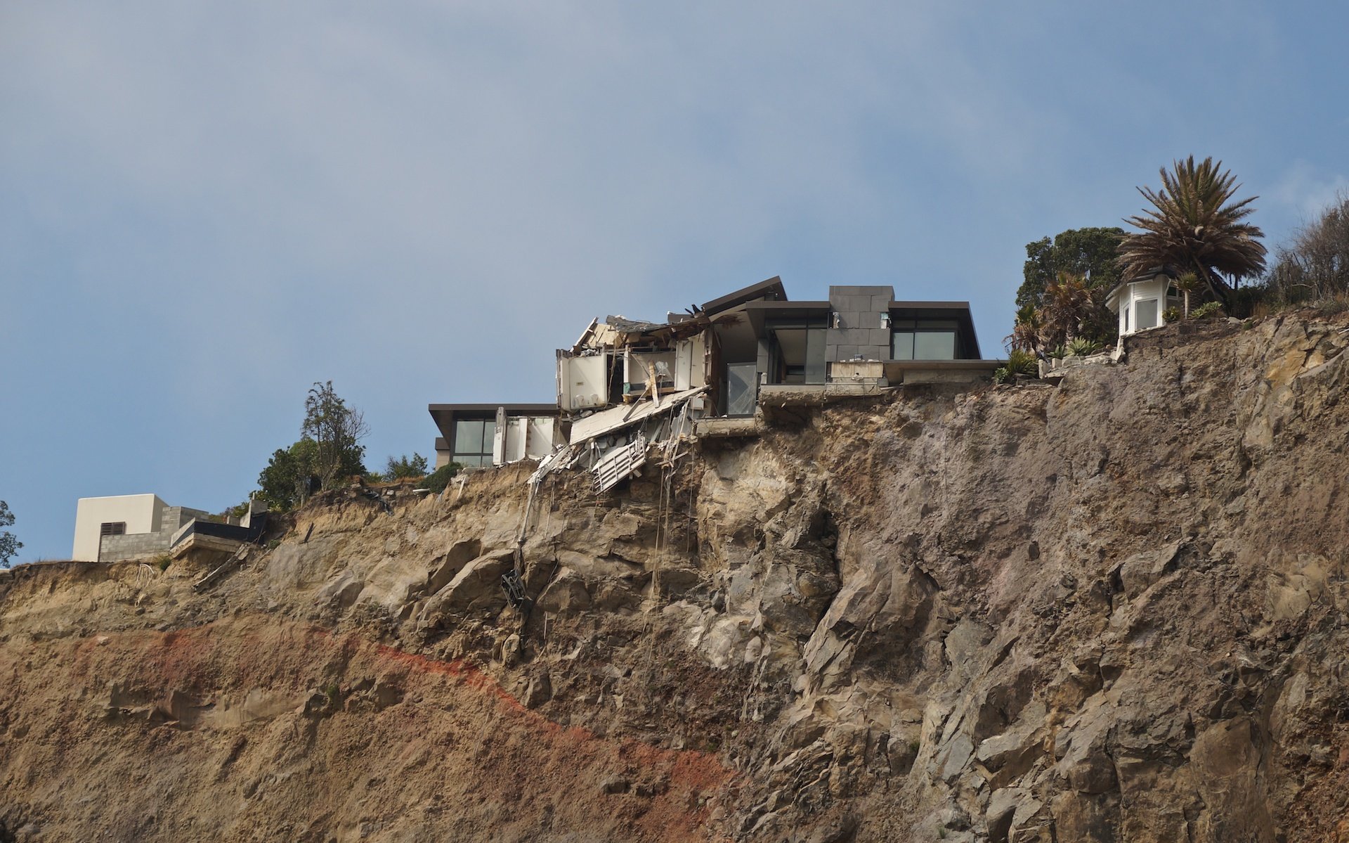
one hilltop family’s post-quake problem

surfers and strollers on Sumner Beach

Sumner Beach warning sign
Perhaps it was simply because it was an hour or so later in the day, but there were certainly many more people at Sumner beach than New Brighton – surfers, strollers, boys playing football, families with blankets spread out…a lively scene.

more surfers and strollers on Sumner Beach!

the view from the south end of Sumner Beach
And then it was time to head up into the Port Hills, apparently the remains of the rim of an ancient volcano. The roads- Summit and Dyer’s- would give me a nice tune-up for the ride over Porter’s Pass and Arthur’s Pass in a couple of days. Unfortunately, I hadn’t thought of the earthquake and its impact; as the images above show, that impact reached all the way to Sumner and beyond. They had also affected the roads crossing the Port Hills.
Not that my updated September 2012 edition of Pedallers’ Paradise had anything about closed roads. Here is its description of the Christchurch earthquakes:
At 4:35am on 4th Sept 2010, the city experienced a 7.1 earthquake. While there was much damage to infrastructure, no-one was killed and only 3 seriously injured. The city is slowly returning to normal.
The second and much more severe earthquake hit in February of 2011 but somehow it was missed in this update! Luckily I had been chatting with a couple of local cyclists down by the beach and was made aware of the road situation up in the hills. I also learned that the iconic The Sign of the Kiwi was closed due to earthquake damage and will need some work done before it can be safely reopened.

looking back to Sumner from Evan’s Pass

Evan’s Pass up in the Port Hills on a Sunday morning – a great place to be!

panorama of Sumner and the beach from Summit Road to the NE of Evan’s Pass
I saw very few vehicles and perhaps a dozen cyclists on their road bikes during the two hours I spent in the Port Hills. This and the views made the effort to get there more than worth it. It would also be the last day in a while that I would enjoy the feel of an unloaded bike; the next day I would be heading off for Greymouth and then Haast via Porter’s and Arthur’s Pass.

Feb 2013- the Sumner-Lytellton Road closed at Evan’s Pass

Feb 2013 – going around the corner for a closer look – a section of the Sumner Road closed

my actual Port Hills bike ride Feb 2013 – check to see if the roads are open!

Evan’s Pass and its roads – the Evan’s Pass Road becomes the Sumner Road at the pass; the Summit Road crosses from left to right; Lytellton Harbour is visible image centre

the Avon estuary in the distance with Redcliff to the bottom right

Summit Road/Mount Pleasant Road junction – Summit Road was closed here in early Feb 2013

the top end of Mount Pleasant Road Christchurch area – the Summit Road was closed at this point

the view north from Mount Pleasant Road

Christchurch in the distance from Mount Pleasant Road
The ride down Mount Pleasant Road was exhilarating, and occasionally I had to apply the brakes to slow things down to a manageable speed. One thing I had already noticed was the absence of those cracks that run across the width of the road; perhaps the freeze-thaw cycle in Canada is such that our pavement ends up with cracks, while the roads of New Zealand (on the South Island, anyway) are not affected by such dramatic changes in temperature. From a cyclist’s point of view, the road quality on the South Island was excellent. The occasional narrowness of the roads would be a different issue that required that I be a bit more alert about traffic.
Once back on the coastal road, I followed Ferry Road all the way back to the city and was soon back at my Riccarton motel. The next day, my South Island tour would begin. You can read about the first leg – the stretch across the Southern Alps to Greymouth – here.
From Christchurch To Greymouth Via Arthur’s Pass
Bicycling South Island New Zealand:: Christchurch to Greymouth