
Table of Contents:
- Why the lower Wanapitei River?
- Getting To The Put-In
- Day 1: Secord Falls To McVittie Dam
- Day 2: McVittie Dam To Hwy 634
- Day 3: Hwy 634 To Sturgeon Chutes
- Day 4: Hwy 634 To Hartley Bay Marina
- The Wanapitei River – Some Background
—————-
Why the lower Wanapitei River?
On the last night of our October 2024 French River Delta visit, we camped at the Sturgeon Chutes, the last dramatic set of falls on the Wanapitei River.
The details of that French River Delta ramble and our visit to Sturgeon Chutes are in the report below –
Up and Down The French River Delta’s Many Channels And Outlets

panorama of Sturgeon Chutes – the last drop
Curious about what was upriver, we filed away the thought of approaching the falls from the north sometime in the future. Well, it is a year later, and our three-day 46-kilometre trip down the Wanapitei to the Chutes is no longer just a thought! The river provided a mix of early fall colour and the occasional waterfalls and portages as we paddled down to the Chutes. Putting it on our to-do list turned out to be a great decision!
From the Sturgeon Chutes, we continued on to Georgian Bay and the Bustard Islands before returning to our vehicle at Smith Marine on the Pickerel River at Settlers’ Road (the old Highway 69). Over eight days of the best early fall weather we have ever paddled in, we covered about 145 kilometres. We count ourselves lucky to have the time, the good health, and the overall fitness to continue experiencing some of the most scenic waterscape anywhere.

our eight-day route down the Wanapitei to Georgian Bay and back to Hwy 69 access here
Getting To the Put-In – Parking & Shuttle
Shortly before 7 on a late September morning, we were ready for the ride up the 400 from Base Camp Toronto –

Since our route was not a loop, we needed a shuttle to the put-in and a place to leave our vehicle while we paddled back to it. We found the answer at Smith Marine just off Settler’s Road (the old Hwy 69) on the Pickerel River.


Access the Smith Marine web page here
We pulled up to the marina reception building at 11:00 to find Chantal and Seb waiting. Our canoe and packs were loaded onto the marina’s pick-up truck, and off we went. [The cost of the shuttle and vehicle parking was $450, tax included.] We headed 50 kilometres up Hwy 69 to our put-in spot below Secord Falls, accessible via the Secord Road from Hwy 69.

—————-
Day 1: Secord Falls To McVittie Dam
- Date: September 27, 2025
- Distance: 8 km
- Time: 1:30 – 3:45
- Rapids: Falls at Km 6
- Portages: 3- to the put-in from the Secord Rd.; around the falls at Km 6; to below the McVittie Dam
- Weather: mixed sun and overcast
- Sightings: MNR fisheries researchers at McVittie Dam
- Campsite: the open area on river left below the dam
- Caltopo link to our GPS track for the entire 8-day route


Our Smith Marine shuttle dropped us off on the side of the gravel road, which you access after crossing the the bridge over the Wanapitei River on the paved Secord Road.
The red line in the sat image below shows the location.

Km 0 Secord Falls Fut-in
There is a 25-meter trail which runs down to a clearing with easy access to the river. We stopped to have lunch by the fire ring. Before setting off we walked along the shore to get a closer look at the Secord Falls and the bridge over the river.


Wanapitei put-in below Secord Falls

The Wanapitei River and Secord Road Bridge

Portaging Around the Falls At Km 6
We had a leisurely first hour of paddling after we left our lunch spot Coming up was our first bit of turbulence. The satellite image I had saved on my iPhone showed a set of falls at the 6 km mark. Since we hadn’t found any info on portage trails or suggested options, we would have to scout the terrain and come up with the best answer.

Wanapitei Rapids 6 km S of Secord Falls

The falls just above the drop

river left view of rapids 6 km from Secord Falls put-in
After checking out the left bank for a possible portage and not seeing anything suitable, we headed over the the right bank. Its sloped rock outcrop made for an easy 240-metre carry. Here is a low-grade satellite image that shows our eventual way down –

240-meter carry around a set of Wanapitei falls

a set of nameless Falls, 6 km downriver from Secord Road Bridge

river right below the falls –
The McVittie Dam
A lower than usual water level as we approached the dam boom on river left meant that we would have to walk through a field of mud to access solid ground and the portage trail. A couple of minutes of attempting to traverse the mud had us move on to the alternative.

We paddled down to the boom and, while standing on the floats, were able to pull our loaded canoe over. We continued on river left for about 30 meters to solid ground, where we unloaded the canoe and hauled everything up to the nearby road/portage trail.
Like other OPG dams we have approached over the years, the safety boom at this one has probably been moved way back from its previous position.

Wanapitei River’s McVittie Hydro Dam and current safety boom location
The portage is about 300 meters and follows the gravel road to below the dam, where it enters a short stretch of bush before ending up on the shore.

OPG’s McVittie Dam Portage Sign

boom across the Wanapitei at McVittie Dam

McVittie Dam from the top

McVittie Hydro Dam’s two intake pipes

The McVittie Dam portage on river left

The McVittie Dam -walking up the road to where we landed
When we got to the end of the portage, we looked around and found an acceptable spot to put up our tent. Since it was approaching 4 p.m. and we had no information on possible campsites coming up in the next hour or two, we decided this would be CS 01. The next day we would find the next decent campsite 19 kilometres downriver. We made the right choice in stopping a titch early.

tent spot below McVittie Dam

our boots after our aborted landing above McVittie Dam’s safety boom


Dusk view of canoe and tent at McVittie Dam
The CN track runs within 70 meters of the Wanapitei shore where we were camped. We were expecting some overnight rumbling of passing freight trains, but it turned out to be a non-issue. The three or four that did pass by reminded us of a similar tent site location at Allanwater Bridge in Wabakimi Provincial Park. There too we had listened to two or three trains passing by on their way to or from Winnipeg. What caught our attention at McVittie was the blaring siren from the dam alerting all nearby about a water flow change a couple of times overnight.
This short YouTube video by Fly North gives a terrific overview of the recent history of Secord Falls and the McVittie Dam. After a brief walk on the river left side by the Falls, he heads down to the Dam. Some drone footage provides a different perspective.
—————-
Day 2: McVittie Dam To Hwy 637
- Date: September 28, 2025
- Distance: 20 km
- Time: 8:45 – 1:30
- Rapids: 1.5 km of swifts and rapids at Km 10
- Portages: none
- Weather: Sunny and warm
- Sightings: boaters docking at Hwy 637 bridge
- Campsite: CS02 on river left below Hwy 637
- Caltopo link to our GPS track for the entire 8-day route
See Day 1 for the initial section from McVittie Dam.

 It was a glorious sunny morning as we set off from the dam with the occasional splash of fall colour to raise the bush-lined river banks to Group of Seven quality.

The next morning, paddling away from McVittie Dam and our tent spot

mid-morning reflections on the Wanapitei River
Coming up was another stretch of the river, which our satellite images indicated has some swifts, rapids, and perhaps falls for us to negotiate.


holding pattern at Wanapitei rapids 2.5 km below McVittie Dam
Lower end-of-season water level meant some bump and grind and the occasional bit of lining as we made our way down a 1.5 km stretch of swifts and rapids about 2.5 km below the dam. We spent about 45 minutes dealing with it. The image above has me holding on to the canoe after a short bit of lining while Max scouted around the corner to see if it was safe to hop in and run.
The rest of the morning was drama-free, and we made quick progress, our usual six to 7 km/hr. We paddled under the Hwy 637 bridge and pulled up on river right at what was an excellent tent site. It was about 1:30 and we had done 20 km. Since our goal for the next day was Sturgeon Chutes, and it was only 20 or so km further downriver, we decided to call it a day.

tent site on river right below the road to Killarney
After a late lunch, we spent some time establishing a portage trail and putting up a few strands of marking tape for the next crew coming through. The image below shows the last section of the trail as it comes down steeply from the rock outcrop to the water.

The portage from day 2 CS
CS02 was a nice spot. Just up from us, two Sudbury guys, each in his own pickup with a camper top, pulled up for their own camping experience. They had accessed the spot by the river via a rough trail coming from Hwy 637. The sat image below shows most of it. They were just up from the red dot that indicates our tent site.

CS02 – the red dot
When we went over for a visit, I was initially confused by what looked like a white tent they were putting up. Why so vertical? It turned out to be an 8’x5′ screen to watch a movie. There was no need for them to put up a tent, since each truck had a mattress in the back.
—————-
Day 3: Hwy 637 To Sturgeon Chutes
- Date: September 29, 2025
- Distance: 22 km
- Time: 8:50 – 3:40
- Portages: one about 7 km below CS02; the other at Bear Chutes
- Weather: sunny and warm
- Sightings: a family of 4 swimming above Sturgeon Chutes; two campers at the Sturgeon Chutes CS
- Campsite: on an island just outside of the FRPP boundary
- Caltopo link to our GPS track for the entire 8-day route


We had already moved the canoe to the other end the night before. With our oatmeal and coffee breakfast done, we carried the four packs and paddles from the CS to the put-in. Before setting off, we paddled up to the falls for a closer look.

Wanapitei River by Day 2 CS below Hwy 634
Another sunny morning with little wind to ruffle up the water … this video clip captures the feel –
Other than the portage around Bear Chutes near the end of the day, there was not much to deal with. A short portage on river right about an hour into the day was the first of them –

Another four kilometres downriver, we spent about 10 minutes dealing with a boulder garden and low water conditions before heading on to the Bear Chutes.
Bear Chutes

Wanapitei Bear Chutes Portage – about 85 meters
We pulled in on river right and dealt with the short portage around the scenic falls. The fall colour only added to the look.

Bear Chutes on the Wanapitei River

below Bear Chutes on the Wanapitei River
With our canoe back in the water, we headed downriver to what we hoped would be a decent Crown Land campsite on the island just outside the boundary of FRPP.
We found an excellent tent spot for our four-person tent. We were able to push our pegs into the earth and, as a bonus, no site reservation was required! Another thing we remarked on was the cell phone connection, which allowed a call to the folks back home!

island CS above Wanapitei’s Sturgeon Chutes
We were clearly not the only ones to have camped on this island, as the fire ring and forgotten rope and other signs indicated. Having already camped at the Sturgeon Chutes campsite (CS647)the previous October, we can say that it is not as nice as this island one.


Wanapitei River flowing past the island above Sturgeon Chutes

Sturgeon Chutes Island campsite
We looked downriver to the Sturgeon Chutes CS and considered the 350-meter portage that would get us to the put-in below the CS 647 the next morning. As the above satellite image with our blue route track shows, we were able to eliminate most of the 350-meter carry by paddling closer to the Chutes before starting our portage.

looking downriver at Wanapitei’s Sturgeon Chutes
—————-
Day 4: Sturgeon Chutes To Hartley Bay Marina
- Date: September 30, 2025
- Distance: 11 km to Hartley Bay
- Time: 2 hours
- Rapids: none
- Portages: none
- Weather: sunny
- Sightings: a few motorboats
- Caltopo link to our GPS track for the entire 7-day route

Day 4 of a string of what would end up being eight days of the best fall canoe tripping weather we have ever lucked into – and it started with an abbreviated portage. Instead of the 350 shown on the Maps by Jeff map, we did about 100. It was before 9:00, and the CS647 campers were still in their tents on the rock outcrop above the falls, so we did our best to tiptoe past as we headed down to the put-in.
Note: We paddled to the top of the Chutes in early October, and water levels were low. An early-season high-water attempt to do it will mean dealing with very different conditions. As always, make decisions based on current conditions and not the route taken by some random guy’s trip report!


Wanapitei River’s Sturgeon Chutes from the bottom – note the tents up top!
If the plan was to end the trip at Hartley Bay Marina, canoe trippers would continue downriver from Sturgeon Chutes to the Forks and take the left fork to Wanapitei Bay. From there, it is a short paddle over to Hartley Bay.
Here is our map of the last day of our 2024 French River Delta trip. It is an 11-km paddle to Hartley Bay Marina.

Your exit point could also be Smith Marine on the Pickerel River at Settlers’ Road (the oldHwy 69). That would involve a full day of portage-free paddling. If you have the time and the weather is agreeable, spending a night at CS634 on Pickerel Bay before heading up the Pickerel to your vehicle at Smith Marina would be our recommendation.
Our plan was somewhat different. We were headed for Georgian Bay and what we hoped would be a night out on the Bustards at another favourite campsite, CS900. The next post will provide some pix and the details of that leg of our little early-autumn adventure!
—————-
Wanapitei River Area – Some Background
The Wanapitei River is a tributary of the French River. Its headwater Lake is Scotia Lake, some 60 kilometres to the NW of Lake Wanapitei. Then it is another 60 kilometres south to its mouth in Wanapitei Bay and the French River.

The Wanapitei River – top to bottom
The Geological Survey of Canada was founded in 1842 with its headquarters in Montreal and directed by William Logan. [Note: Canada at that time referred to the territory of the pre-Confederation Province of Canada, made up of the southern parts of today’s Quebec and Ontario and with Kingston as the capital.]
The GSC’s aim was to map and catalogue mineral, agricultural, and timber resources so that the Province’s economic development could be more effectively planned.
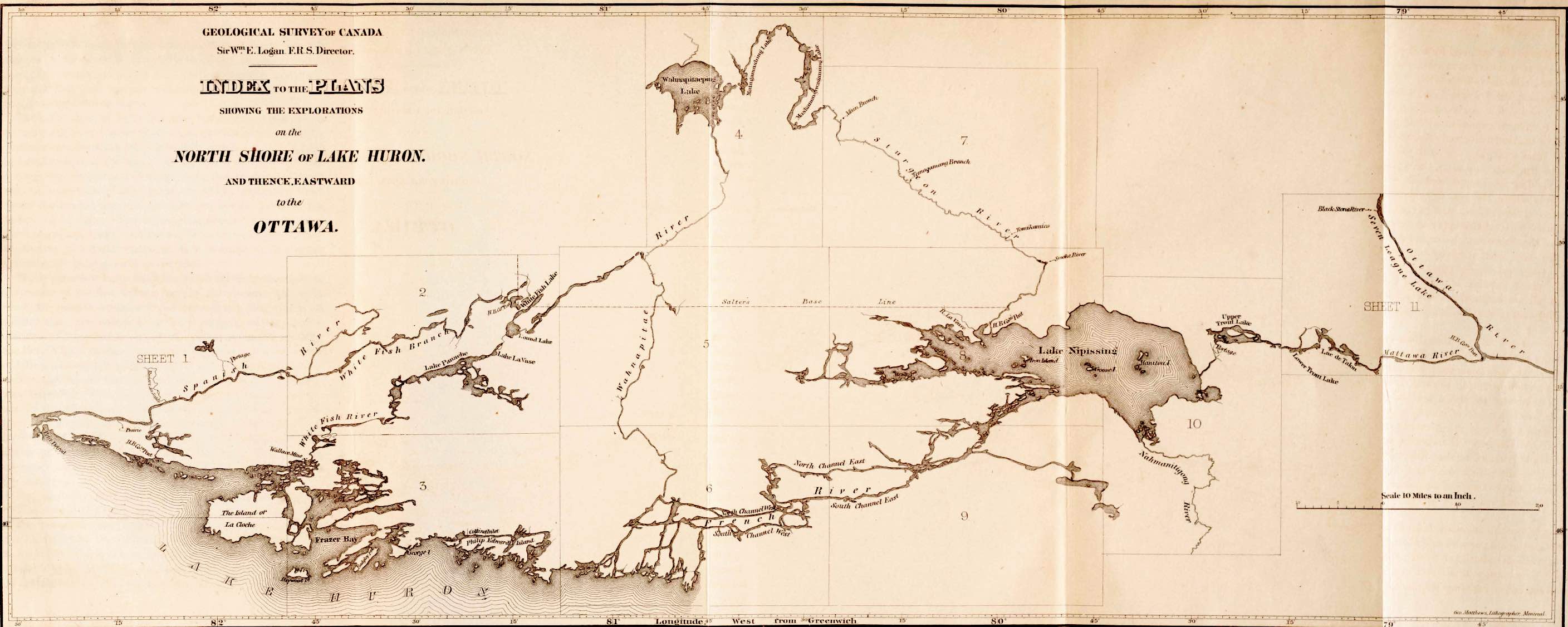
The map segment below dates to the early 1850s and shows the Wanapitei River from Wanapitei Lake down to Lake Huron.

1856 – Geological Survey of Canada mapping of Lake Huron’s north shore
Access the entire map sheet here.
These days, the Wanapitei has been impacted by four dams, of which 3 are hydroelectric generating stations , while the northernmost one is a control dam. The industrial development of Sudbury required increasing amounts of electrical energy, and these dams were part of the answer.
- Wanapitei Lake outflow control dam, which was built in 1927
- Sinson Generating Station, 20 km south of the control dam, 1925, 5 MW capacity
- Coniston Generating Station
- McVittie Generating Station – 1912 with a 4 MW capacity

The Anishnaabe (aka Algonkian)People
The lives of the first inhabitants of the area – Anishnaabe people, whom we know by names like Ojibwe and Cree – would be heavily impacted,
- first, by the development of a fur trade barter economy in the two hundred years before the 1850s, and
- then by the increasing flood of newcomers interested in lumber, minerals, farm land, and railway building
- and the signing of various treaties (in this case, Treaty #5 – The Robinson-Huron Treaty of 1850) – which dispossessed them of their land

See this post on a trip we did down the Chiniguchi and Sturgeon Rivers for our attempt at understanding some of this recent history –