
Table of Contents:
- Intro – A Sudden Change of Plans
- Finding Local Quito Climbing Agencies
- The Logistics of Volcano Climbing in Ecuador
- My Acclimatization Plan
- Base Camp Quito – Gringolandia Accommodations
- Acclimatizing In Quito – Visiting The City’s Attractions
- Walking Up Rucu and Guagua Pichincha
- To The Top of Iliniza Norte
- How To Organize Your Trip
Next Post: Climbing The Three Highest Peaks of Ecuador’s “Avenue of the Volcanoes”
——————
Introduction: A Sudden Change of Plans!
The phone call from Alaska Mountain Guides was unexpected – and the news was not good. The voice informed me that my upcoming early – February Ecuadorian Andes mountaineering trip was cancelled due to the illness of the guide, who apparently had to return to the US for treatment. They would, of course, reimburse me and offered a $500. discount for a future trip. Click here to see the sixteen-day package I had signed up for.
All blue text leads to a new page with a click; all images are expandable with a click.

old town Quito – aka El Centro – and La Virgen de Quito, on top of the hill called Panecillo – shot taken from the roof of the Basilica del Voto Nacional to the NE
So – what to do? I had already purchased the plane tickets and, more importantly, I was totally psyched, having been working out at the gym, brushing up on my basic Spanish, and informing myself about the various climbing peaks as well as on Quito and Ecuador in general. My decision to go ahead with the trip on my own turned out to be the right one. I would spend a fantastic two and a half weeks climbing peaks in the Ecuadorian Andes, essentially using Quito as my base camp.
In the end, I was able to check off most of the items on the AMG itinerary and add a few new ones – all for 60% of the cost of their trip. Along the way, I would also find out that the trip had been cancelled because there had only been one client booked. When I said: “I know; I was that one client!” the guide had to laugh. It’s a small world!

acclimatization climb on Iliniza Norte- the blizzard was a bonus challenge!
——————
Finding Local Quito Climbing Agencies
Scouring the various guidebooks and the internet for Quito-based climb organizers, I came up with one which had some good reviews. Moggely Climbing is located on Avenida Amazonas in La Mariscal district and had a few trips that would hit all the high spots. When I found out that another climbing group was looking for a fourth, that was even better. Now instead of paying the single-client rate (steep!) I was looking at relatively “cheap”! The five-day package included climbs of Cayambe and Chimborazo and an acclimatization day spent on the slopes of Cotopaxi as high as the 4800m José Ribas hut.
I prepared for the major climbs with nine days spent in and above Quito, giving myself lots of time to acclimatize. This is where Rafael Martinez, the owner of World Bike in Quito and ASEGUIM–certified mountain guide, came into the picture. (See ASEGUM’s member list page for his email address.) After having done the Rucu Pichincha hike on my own, I hired him for acclimatization hikes to Guagua Pichincha (4784m) and then south of Quito to the Ilinizas before I set off with the other guys on our Moggely adventure. After our return from Chimborazo, he would also guide me to the top of Cotopaxi. I was fortunate to have stumbled into his agency! My preparation time also meant that altitude sickness was never an issue.

returning to Cotopaxi hut (4800 m) from an acclimatization hike a bit higher
——————
The Logistics of Volcano Climbing in Ecuador
Do note that climbing in Ecuador is a bit different than climbing elsewhere – e.g. the Cordillera Blanca in Peru or the Himalayas. For starters, Quito (2800m) becomes a de facto base camp from which most trips start. You leave the city at 8:00 a.m. and get to the mountain hut by 4:00 p.m.- 4600m for Cayambe; 4800m for Cotopaxi; and 5000m for Chimborazo. A few rules of acclimatization will already have been broken here-
- a maximum ascent of 500 m a day;
- walk high, sleep low; and
- an extra day’s rest after every 1000 meters of ascent.
When you get to the hut, you check your gear one more time, have supper, and then you try to get some sleep before the 1 a.m. wake-up call. Finally the ascent to the top – another 1100 meters. You’re now 3000 meters higher than you were 24 hours ago. You get back down to the hut by ten or so and by four in the aft you’re back at Base Camp Quito! You’ve been gone for 32 hours. Your body has every right to rebel! Time to rest and plan the next ascent…

Ecuador’s “Avenue of the Volcanoes”- the focal point of my adventure- click here for a “live” Google Map you can zoom in or out on. Arrows point to peaks I climbed- or tried to!
——————
My Acclimatization Plan
My extended acclimatization plan did not include the use of Diamox! It did include ascents of the following peaks over the first nine days-
- Rucu Pichincha- 4680 m – on Day 3 after a ride up on the TeleferiQo to 3945 m
-
Guagua Pichincha- 4794 m
-
Eliniza Norte- 5126 m
-
Rucu Pichincha again- this time with my three partners from Moggely

the trail up to the peak of Rucu Pichincha- my first acclimatization walk
With this acclimatization, I was ready for the main feature –
- Cayambe- 5790 m
Cotopaxi- Ribas hut – 4800 m bonus acclimatization hike
- Chimborazo- 6310 m
-
Cotopaxi- 5897 m
Read on to see how I spent the first nine days allowing my body to acclimatize for the three highest peaks in Ecuador. The next post will go into a bit of detail on each of the three major climbs.
——————
Base Camp Quito – Gringolandia Accommodations

“Gringolandia” in Quito, Ecuador map – click here for the interactive Google map
The 10-km taxi ride from the Aeropuerto Mariscal Sucre to my hostal was a quick one and soon I was in my barrio- known to the locals as La Mariscal. It is the location of many hotels, money exchanges and banks, hostals, laundromats, restaurants, bars, internet cafes, and travel agencies catering to travellers looking for specialized tours and itineraries. In fact, there are so many tourists here, it is also known affectionately (I hope!) as “Gringolandia”.

Calle Juan Rodriguez in La Mariscal Sucre- a quiet street in a busy district
My room was at the very basic but acceptable Hostal Arco Del Sol, one of a number of budget places to stay on Calle Juan Rodriguez, a very quiet street close to everything you need to access. At $14. U.S. a night (including an American-style breakfast) my bill came out to about $200. for the 14 nights that I booked the room- the first eight nights and then the odd night here and there as I moved into the heavy-duty climbing part of the trip. The Cayman Hotel across the street looked a bit more upscale, as did the Hostal El Arupo next door to mine. If I could do it over again, I would take a room in the Old Town for at least a couple of nights to experience a different part of Quito. I was especially charmed by the Hotel Real Audiencia, a definite three or four stars up from my budget hovel!

Hostal Arco del Sol- one of the half-dozen budget lodges on the street

my room at Hostal Arco del Sol- a quiet budget retreat in Quito’s Gringolandia

the colourful front of a house on Calle Rodriguez

streetscape around the corner from Hostal Arco del Sol
The tourist ghetto has a bad reputation for muggings of tourists and worse, which the internet does a fine job amplifying! So it was with some trepidation that I went for my first walk around my barrio. As is often the case, the reality I found was little like the Gringolandia of the travellers’ forums. I did see special tourist police patrolling the area; I also made a point of not walking around by myself after ten when the alcohol kicks in and young males start doing stupid stuff.
——————
Acclimatizing In Quito – Visiting The City’s Attractions
If I could change one thing it is this- I would not bring my brand-new massive two-pound DSLR on city walks and point it at people like the bikers in the photo below- who were probably wondering why I was taking their picture! A smaller p & s- a Canon S100 or a Sony RX100- would have been perfect- unobtrusive yet capable cameras that would allow you to photograph the streetscape of a fascinating city when not tucked in a chest pocket.

the corner bar steps away from the John Lennon wall
I spent the first two days just exploring Quito itself. The Old Town (aka El Centro), the historical part of Quito which dates back to the 1500s, is a walker’s dream. Stunning architecture around every corner- and lots of photo ops. Here is a bit of what caught my eye-

the view from the Plaza San Francisco

San Francisco Plaza with Panecillo and La Virgen behind

the front facade of Monasterio de San Francisco on the west side of the Plaza

detail from one of the doors of the Monastery of San Francisco

pedestrian-only street in the oldest part of Quito

old Quito street scene

old town Quito

the Plaza Grande (aka La Plaza de la Independencia) with the Palacio Gobierno on the top left (with flag)- the steps lead to the cathedral

people enjoying Plaza Grande in El Centro (the historical part of Quito)

traffic jam on Calle Garcia Morena going down to the heart of the historical centre- El Centro

looking up to the Basilica del Voto Nacional from the portico of El Palacio Gobierno on a rainy day

the cathedral on the SW corner of Plaza Grande

the Plaza Grande from the portico of El Palacio Gobierno

the interior of la Basilica del Voto Nacional

major stained glass work at the Basilica del Voto Nacional

looking NE towards the new town from the roof of the Basilica del Voto Nacional

doors of the Basilica del Voto Nacional- up the hill NE of Plaza Grande

standing underneath La Virgen de Quito on Panecillo hill

La Virgen de Quito up close

El Centro- the Old Town- as seen from Panecillo Hill

The panoramic view from the patio of Cafe Mosaico – a great spot to sit and relax for a bit

The Magic Bean in La Mariscal district- one place I found good vegetarian food options
During my time in Quito, I spent a half-day at a major international orchid exhibit; I visited some churches in El Centro, including a couple of hours spent at the Basilica del Voto Nacional; I took a taxi to La Virgen de Quito to check out the view from there; I visited museums and art galleries and all sorts of other things that a 500-year-0ld city of 2.5 million has to offer. I also spent time sitting in restaurants chosen for their veggie-friendliness and in internet cafes sending the occasional progress report home to my wife or checking up on the fortunes of my Toronto Maple Leafs hockey team.
")
Beauty in randomness- fallen leaves in Quito’s Botanical Gardens (Parque Carolina)
——————
Walking Up Rucu and Guagua Pichincha:
Yossi Brain’s Ecuador: A Climbing Guide was published in 2000, a year after the eruption of Guagua Pichincha (4794 m) left Quito covered with a couple of centimeters of ash. As a result, he notes the obvious restricted access to the peak at that time. About 5 kilometers to the NE, just past Padre Encantado (4685 m) is Rucu Pichincha (4680 m), the third of the three Pichincha peaks which were all once different points on the rim of the caldera before it collapsed to its present shape. Here is what Brain has to say about making Rucu your first acclimatization objective-
Warning: On no account try to climb Rucu Pichincha alone or in a group – the incidence of robbery (including armed), assault, and rape is far too high to justify the trip. (Brain, 70)
Well, it is more than a decade since the book was written and the situation has changed for the better. Guagua has been quiet since that 1999 episode and I was able to include it in my acclimatization program. We were able to drive the SUV up to the parking lot near the Refugio at about 4100 m and then walk the rest of the way up to the top. As for Rucu, since Brain’s book was published, the TeleferiQo has been built and has become a major tourist draw in Quito. (It opened in 2005.) Click here to see the Google satellite view of the area.
The first time I went up it was a Sunday and many local families had obviously made at least the ride to the top a part of their holiday plans. At Cruz Loma, the top of the ride, there are restaurants and souvenir shops. A number of them were closed when I was up there; it seemed as if there was not quite enough traffic to support the number of food outlets they had.
Some people continued walking the very obvious trail to the summit- it takes about three hours from Cruz Loma – and I was never alone. The second visit was on a Saturday and I found the TeleferiQo as busy as before; this time I was with my three climbing partners. Today’s guidebooks reflect the changed conditions and should allay any fears about venturing up to the peaks of Pichincha, although this does not mean that common sense and a bit of caution should be forgotten.

looking back at the trail from the TeleferiQo with Quito down below

horses available for a ride along the trails going up to Rucu

cloud and haze meet over Quito

Rucu Pichincha summit- the approach is a scree scramble to the right and behind

hikers walk the trail to the cloud-covered peak of Guagua Pichincha
A good day hike would be going up on the Guagua side, visiting the peak, and then walking over to Rucu Pichincha via the trail which passes underneath Padre Encantado. You’d need a ride to the start of the trail and perhaps a guide (for your peace of mind) to get you to the TeleferiQo and back to The Magic Bean for supper!
——————
To The Top of Iliniza Norte:
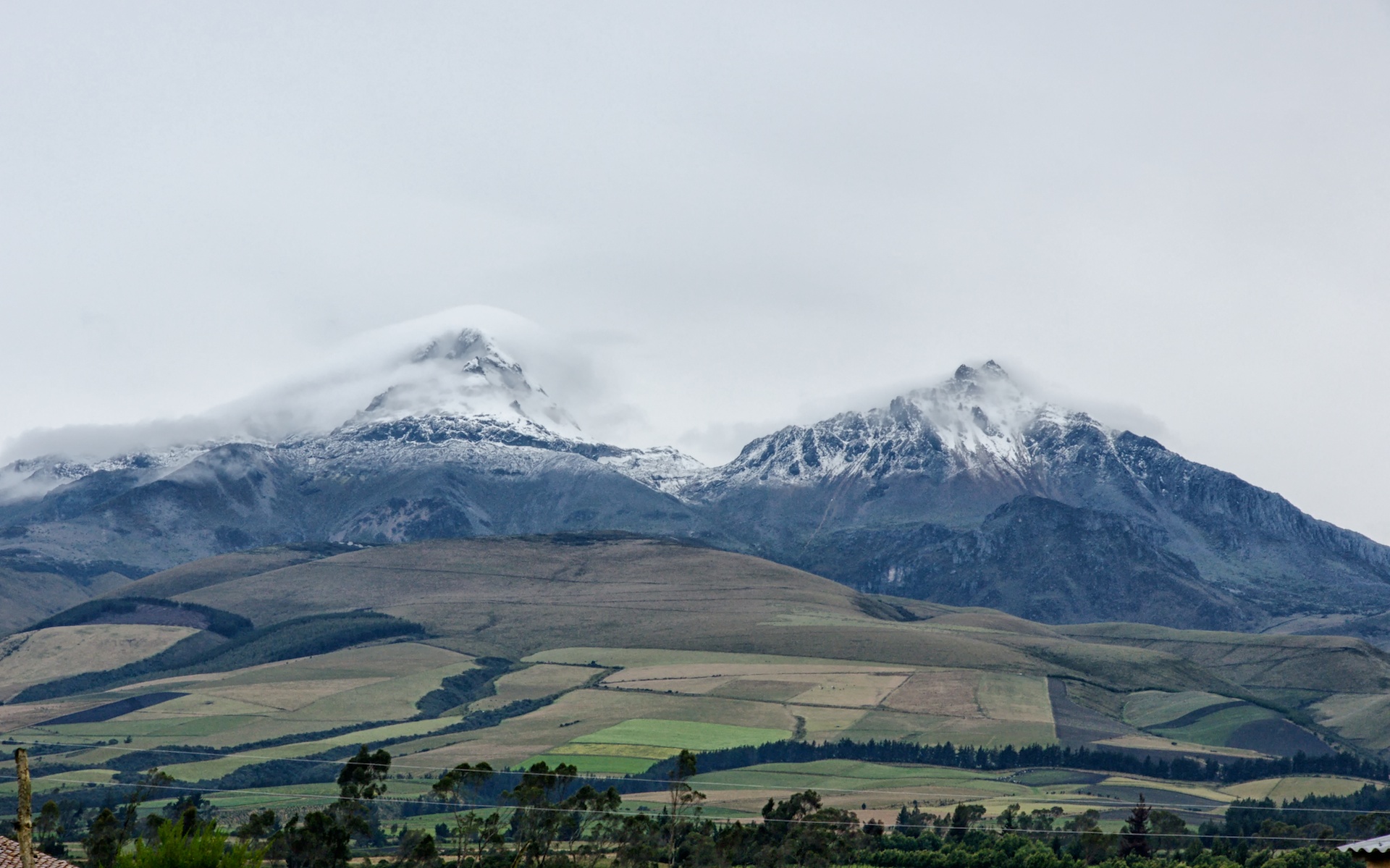
first view of the Ilinizas- Sur and Norte- cloud and snow swirling around the peaks
After passing Machachi, 43 kilometers south of La Mariscal on the Panamericana, it is another 10 kilometers to El Chaupi, the gateway village to the Ilinizas. (Click here for the driving directions.) We drove through the village to a hostal where we would spend the night, but not before an afternoon spent walking the trail from la Virgen shrine to the Iliniza Refugio. We would return the next morning and do the walk up to the summit of Iliniza Norte- a non-technical route that involves scampering over some loose scree. The mini-blizzard that we walked through did put a nice layer of snow on everything and made it a bit more interesting. We did wear our helmets in case of rockfall.

the road up to La Virgen, a 9-kilometer ride from El Chaupi
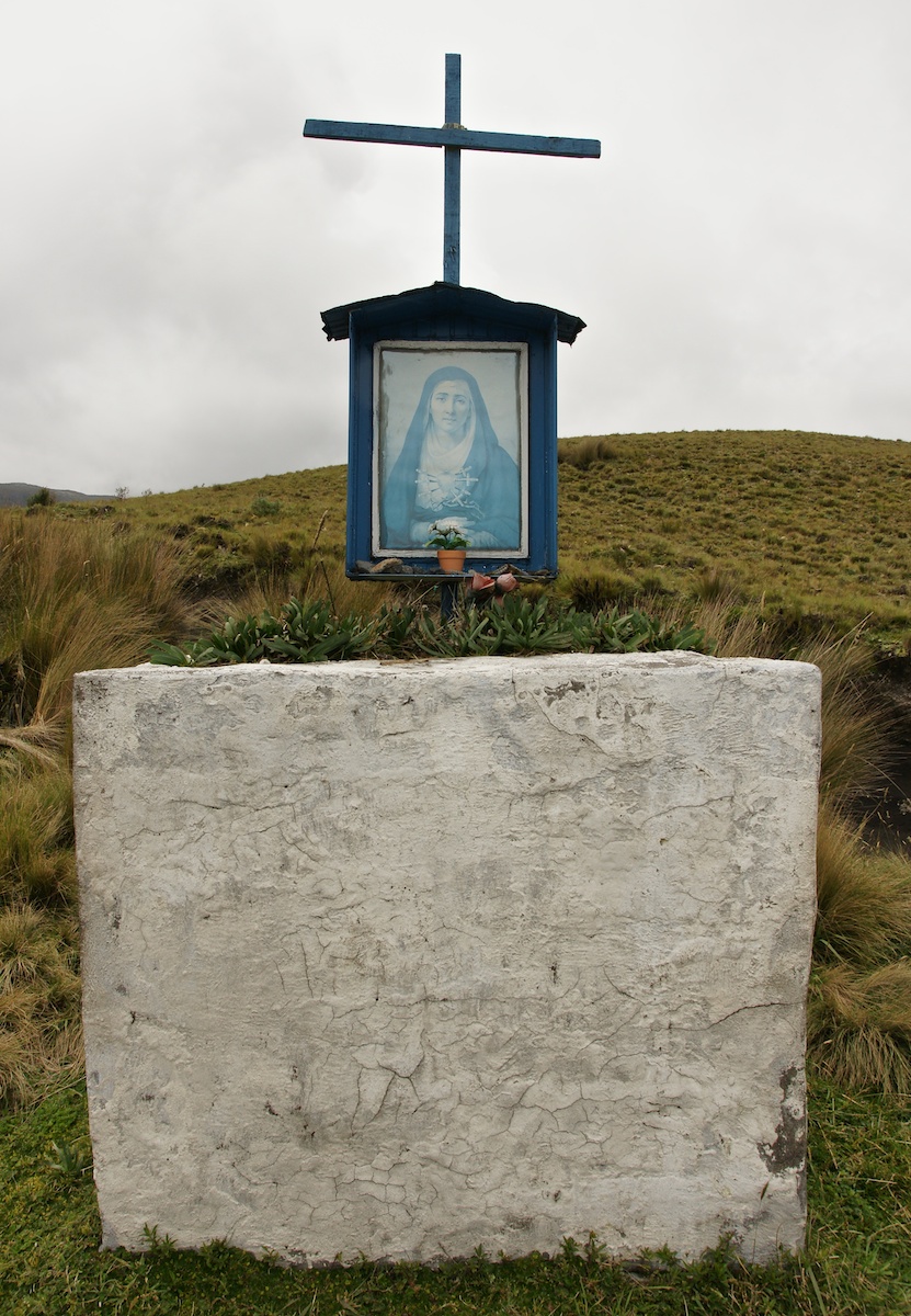
La Virgen shrine (3950 m) – parking lot nearby
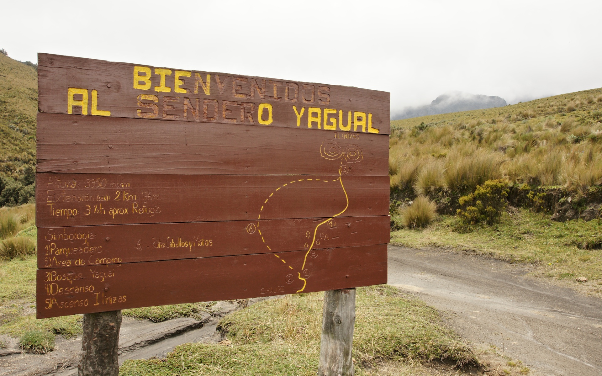
trailhead map near La Virgen shrine

opening the cattle gate on the Illiniza road

snow and blizzard on the way to Iliniza Norte summit

standing on the top of rubble called Iliniza Norte!

mi Guia muy simpatico- Rafael Martinez- on top of Iliniza Norte
On our way down from the summit, we passed by three climbers who were headed up to the top. Well, amazingly enough, these were the three guys I was to do the Moggely package with – but we hadn’t met yet. Here we were on an exposed ridge on the saddle between the two Ilinizas in a blizzard- gloves off, shaking hands…and pleased to see that everyone was making sure to be acclimatized for the upcoming climbs. I gave them the name of my hostal in La Mariscal and a few hours later, they checked into the last available room. Two days later we all went up to Rucu Pichincha for yet one more time at a higher altitude before we finally moved on to the first of the major peaks on our list.

no great views from the top of Iliniza Norte this day!
——————
Organizing Your Ecuador Volcano Climbing Trip
The Deluxe Route
You’ll need to hire the services of a climbing company. The deluxe way to go is the way that I was originally planned to go – i.e. a company based in the U.S., Canada, or in Europe. By deluxe, I mean full service where someone does all the planning for you and the price is perhaps double what you can arrange if you go directly through a Quito agency. The non-Ecuadorian lead guide will end up hiring from the same pool of Ecuadorian guides you can on your own. Many of them offer Ecuadoran Volcanoes mountaineering packages.

I am not sure why but I ended up with Alaska Mountain Guides and their program. Click here to see the details.
Another possibility for the deluxe route is Mountain Madness, the company founded by Scott Fisher; it has an Ecuadorian trip here.

The American Alpine Institute is the last one I’ll mention, given its solid reputation. Click here to see their fifteen-day trip.
———–
Going With A Local Agency
As mentioned at the very beginning of this post, I ended up going down to Quito with a five-day package already arranged with Moggely, a Quito-based agency run by a Swede and his Ecuadoran (ex-)wife. Like the other agencies, it hires available guides from a pool of guides who are accredited by the Ecuadorian Mountain Guides Association (ASEGIUM) and should have a card to prove it.
![]()
Click here for an up-to-date list (2012) of members. Also check out this link to a Lonely Planet thread dealing with hiring a guide once you get down there- it contains some good discussion.
I completed my itinerary by doing the pre-big-climb acclimatization hikes on my own or with the services of Rafael Martinez, the owner of World Bike, located in Quito’s La Mariscal. Martinez is also an ASEGUIM-certified guide whom other guides I later met told me had been their instructor when they were being certified. Here is the most current info on him from the ASEGIUM Members List –

Martinez is about 50 years old and speaks excellent English so communication was never an issue. He knows these mountains and everyone seemed to know him. I wouldn’t hesitate to put together another Ecuador adventure with him as the guide. Do note that he seems to be the target of an online enemy. Google his name and read some of the stuff and it may well scare you away. Someone obviously feels hard done by; this was not my experience.
Obviously, there are other guiding agencies in Quito which, I am sure, also do a fine job for their clients. The one that almost all guidebooks praise is Compania de Guias de Montana.
Other names that come up often are Gulliver and SurTrek. All of them can be found in La Mariscal district. I can’t really comment since I didn’t use them- although I realize in the end that the particular guide you are assigned can make or break the trip. If you get one who is disinterested and looking for a feeble excuse to call the summit off or to turn back, then it doesn’t matter which company you’re using! Read this post in the Lonely Planet Forum from a climber – and all the responses from fellow mountaineers- who made use of Gulliver. It is instructive.
Click here for the follow-up post about my climbs of Cayambe, Cotopaxi, and Chimborazo- the three highest peaks on Ecuador’s Avenida de los Volcanes.
The phrase was coined by the German geographer/naturalist extraordinaire Alexander von Humboldt in the early 1800s when he visited the area.
——————
See Part Two: Base Camp Quito: Climbing The 3 Highest Peaks of Ecuador’s “Avenue of the Volcanoes”
Really appreciate the time taken to post the details of your trip – heading to the area March 2018 for some day hikes and car camps through the Avenue of Volcanoes. Great insights in your article!
Daniel, great choice of destination! The Ecuadorian highlands was a fascinating place to spend some time. Since my visit, Cotopaxi erupted and was off limits to climbers until late last year. You can drive up to just below the Refugio!
I never did get down to Cuenca but it sounds like a charming town to spend a few days in. Maybe next time!
In the meanwhile, enjoy your visit!
Very good article, Ecuador is one of the greatest countries I ever visited. Cotopaxi now is open again and many people reach the summit. The rest of the cities such as Cuenca, Otavalo, Quito are just stunning. Very nice and friendly people. Highly reccomend it to visit. Give a call to the operators this article mention as well.
Ecuador is definitely an overlooked destination that has a bit of everything – from beaches to 6000-meter volcano tops! I never did get to Cuenca but hope to one day. Another country on my radar is Colombia next door. More great national parks, a high-altitude capital city, and more incredible beaches and, like Cuenca, another town with charming colonial-era architecture in Cartegena.