
Table of Contents:
- Day 9 – Daren to Taitung
- Day 10 – rest day in Taitung
- Day 11-Taitung to Chishang
- Day 12-Chishang to Guangfu
- Day 13-Guangfu to Taroko
- Day 14-Taroko Gorge /train to Yilan from Xincheng
- Day 15-Yilan to Jiufen
- Day 16-Jiufen to Taipei
————-
On Day 8, the halfway point of my bike ride around Taiwan, I left the west coast of Taiwan and headed east. See the previous post for details on the ride across the Central Mountain range.

As pleased as I was with how the trip had gone so far, the second half would feature even more breathtaking scenery, quieter bike lanes and trails, and less frantic towns to enhance the experience. It also included an unexpected bonus – a ride up Taroko Gorge to Tianxiang.
It’s no surprise that organized bike tours almost always plan their routes around the roads and towns along Taiwan’s East Coast!
————-
Day 9 – Daren to Taitung
- date: April 6, 2025
- weather: overcast
- distance: 67 km.
After the ride up County Hwy 199 to and over Shouka Pass, I started my ride up the Pacific coast from Daren on yet another overcast (but not raining) day. As the elevation profile for the day shows, there are three moderate climbs to deal with as you head north on Highway 9. I would be on #9 almost all the way to Hualien, and, after the sometimes heavy traffic on the first half of the trip, my road photos for the next few days would rarely have more than a vehicle or two in them.

Provincial Highway 9

The satellite image below is of Daren; my room for the night was in a hut in the cluster of buildings closest to the beach.

Daren – Hwy 9 and the Pacific Ocean
Highway 9, as I left Daren on a Sunday morning at 8:45 – very quiet!


It did not take long to reach Dawu. Given my early arrival at Daren the day before, I could easily have reached Dawu or continued even further. It was my misplaced concern about finding a motel room that had me take the available accommodation in Daren.

The Hwy 9 sign with the number of kilometers to its north end in Taipei –

Break time at Family Mart – some fruit, a bag of nuts, and a sugary emery drink –

Along with the previous day’s ride over Shouka, this day ranked as the most scenic and enjoyable of the trip so far.

The elevated railway line running alongside Highway 9


I got to Taitung in the early afternoon, checked into my hotel – The Tin Tinn Inn – for a two-night stay. After carrying my panniers and the bicycle up to the third-floor room, I showered, relaxed a bit, and then went for a walk around the downtown area of what seemed like a lively, well-maintained community.
The Tin Tinn is the four-storey building in the image below.

the Tin Tinn Inn in Taitung


————-
Day 10 – Rest day in Taitung
A day off the saddle, a day to chill, a day to sit at the outdoor patio of the coffee shop down the street from my hotel and watch the world go by – it is something I should have done in Hsinchu and Tainan and Kenting Town and a couple of other towns on the route – – but then my 16-day bike ride would have morphed into a 21-day extravaganza. Amazing to think that the official recommendation for the round-Taiwan trip is 8 days!

A Giant bike shop – Giant is the world’s largest maker of bicycles and is based in Taichung.

Other than that coffee shop, I spent time fueling up in Happy Cow-recommended restaurants in the city.


Earthquakes regularly rattle the east coast of Taiwan. I watched the construction crew working on the site, curious about the amount of steel reinforcements they were using.


The Buddhist swastika symbol on a sign indicates that vegetarian food is available. I entered the shop below and found shelves of veg-friendly items, as well as a Buddhist monk who happened to be doing some shopping. I stocked up on a few things for the next day’s ride.


Then it was back to the coffee shop for a late afternoon cup of coffee and, after a quick detour to my hotel room, a visit to a nearby vegan restaurant. Misreading the menu, I ordered a bit more than I had intended. It all got consumed!


way too much food ordered at a vegan food stall with a few tables
An after-dark stroll in the neighbourhood coincided with the passing by of the city garbage truck, letting shopkeepers and residents know of their arrival in the most delightful of ways.
————-
Day 11 -Taitung to Chishang
- date: April 8, 2025
- weather: overcast
- distance: 56 km.
- Ride with GPS File
As most of my images show, it was often overcast as I cycled the roads and bike paths of the island. This Wikipedia statement in a Taitung City entry may explain why –
Taitung has a tropical monsoon climate, with a wet season from May to October, a dry season from November to April, and consistently very warm to hot temperatures with high humidity. Unlike most tropical climates, however, the dry season is foggy rather than sunny…
Unlike a January bike tour of eastern Cuba, where the intense rays of the sun had me doing most of my cycling before 11:00 a.m., the overcast weather made the cycling easier.
This day would be a half-day of cycling as I continued on Highway 9 inland from Taitung to the Eastern Rift Valley, a 160-kilometre-long narrow band of prime agricultural land framed by the Central and Coastal Mountain ranges. I would be on between all the way to just before Hualien, where I accessed a coastal bicycle path that took me to Taroko Gorge.
The image below is of the bicycle path as it leaves Taitung. It was about 9 a.m., and I had just finished the buffet breakfast at St. Mary’s Health Club, located in the Roman Catholic church in Taitung.

leaving Taitung for Chishang
I would soon be approaching the floodplain of the Luye River, a tributary of the Beinan River.

Beinan River in Taitung County

Highway 9 approaching the Luye River bridge from the south

approaching the Luye Bridge
Just beyond the Luye Bridge is a shopping mall where I stopped for a cup of coffee at yet another 7-Eleven. That’s my bike on the other side of the window, unlocked but in sight!

7:Eleven stop Hwy 9 Yangping
The Beinan River has a total length of 84 km. Hwy 9 runs alongside it almost all the way to my day’s destination, Chishang. Thanks to a commercial by a Taiwanese coffee company named Mr. Brown, which they filmed in the Chishang area near Hwy 9, tourists have since flocked to the area. For folks from Taipei or the densely populated west coast, the open space and green fields of the Rift Valley represent the flip side of their everyday reality. In the image below the elevated structure is the rail line.


a detour into farmland – Mr. Brown’s Blvd area
Back in Hsinchu on the morning of Day 2, I had left my charge cord for the Garmin watch behind. The hotel front desk found the cord and mailed it forward to my accommodation at Chishang. I was looking forward to using my watch again for its GPS and live tracking capability so that Laila back home could follow along as I cycled up the Pacific coast of the island. I was in Chishang so early- noon – that I headed to the train station and a nearby vegan restaurant.

Chishang – Hwy 9
The restaurant only had one thing on offer – but it was exactly what I wanted, some nutritious food that would replenish my fuel supply. I ordered a second box to take away with me. It would be the next morning’s breakfast.

breakfast box – plant-based fuel
There was some disappointment when I learned that the charger cord had not arrived at the hotel. I left my bicycle in a side room on the main floor and headed up to the room. The two images below are of the balcony views I had of the new buildings on the town’s eastern edge. Chishang serves as a farm supply center and looks fairly prosperous and, as with almost every other place I cycled through, well-maintained and graffiti and litter-free.

Chishang – view from my 5th-floor window

Chishang – a view from my room window
My accommodation was very close to Main Street- i.e.. Hwy 9 as it passes through town- and I wandered over to the coffee shop. At dusk, I headed up Main Street and down a side lane to a recommended vegetarian restaurant. See below for a shot of the outside of the place, as well as the way-too-much food I ended up ordering.

Main Street, Chishang, at dusk

Chishang -commerce street – dusk

image from Happy Cow web page


I emptied both plates! This day I set a record for the amount of food consumed. It made up for some more Spartan 7-Eleven meals I had when nothing else was available.
On the way back to my room, another brief encounter with the evening garbage collection…
————-
Day 12 – Chishang to Guangfu
- date: April 9, 2025
- weather: overcast
- distance: 72 km.
- Ride with GPS File
As the day’s elevation profile indicates, a very easy day was coming up. I wanted to be in Taroko Village the following afternoon, and Guangfu was a convenient halfway point. It is a farm supply town of 10,000 surrounded by rice fields. The pics below


a bowl of soup for lunch
My supper that night was another serving of one of 7-Eleven’s two vegan offerings.

Guangfu and Typhoon Ragasa
In September 2025, Guangfu was in the news because of the flooding caused by Typhoon Ragasa. The New York Times article linked below provides details of the catastrophic flooding and loss of life.

As Typhoon Ragasa neared Taiwan, rain pounded a little-known lake in the upper reaches of a mountain range on the island’s eastern coast.
After nearly two days, the lake burst through its dams on Tuesday afternoon, unleashing torrents of water that careered down the side of a mountain and inundated the rural town of Guangfu, home to 10,000 people.
————-
Day 13 – Guangfu to Taroko Village
- date: April 10, 2025
- weather: overcast
- distance: 71 km
- Ride with GPS File
The day’s images below show another day with cloud cover. As for the road, it was mostly flat or downhill until Hualien and then a flat ride along the coast before I turned inland to Taroko Village.


bird gathering spot off Hwy 9


pathway to Hualien Estuary Wetlands

Hualien Estuary Signboard
“Now this is more like it!” I thought as I cycled into the photo below.

ocean front trail north of Hualien

bike path N of Hualien with ocean views
As I cycled past the bottom of Hualien’s downtown area, I made a detour for a restaurant recommended by my Happy Cow vegan restaurant finder app. It was the typical Taiwanese vegetarian buffet with several excellent choices, where you load your plate with what you want and then are charged by the weight of the plate. I went back for a second helping.

cemetery near Kangle village and Kung Long Museum
As I passed by the cemetery in the photo above, I noticed a couple of cyclists in the shade on the other side of the road. It was the Montreal couple I had last sat with at the southern tip of the island at Cape Eluanbi four or five days before.

It was a lucky encounter. I had planned to cycle up to Yilan early the next morning via the reputedly dangerous road tunnels. They convinced me that I was taking an unnecessary risk when a local train ride would bypass the worst stretch of the upcoming road.
They did have an alternative! They had found out that a ride up Taroko Gorge was indeed possible. While the impact of the April 2024 earthquake was such that the hiking trails will likely be closed for years, traffic was now being allowed through at certain set times during the day.
We would have to be at the east end traffic control gate at 7 the next morning when it opened for 15 minutes. We would be able to return from Tianxiang when the gate on the west end opened at 10 or at 2. While I had crossed the Taroko Gorge ride off my to-do list, this was fantastic news.
I gave them the contact info for my Taroko Village hotel. Later that afternoon, after I had checked in, they arrived. Even better, they had relayed our plan to cycle up the Gorge the next morning to the Calgary couple who were also in the Hualien area, and later that evening, they too arrived at the Liwu Hotel. Our all-Canadian up-the-Gorge team was ready to roll!

cloud and mountain off Hwy 9 on the way to Taroko
The Central Cross-Island Highway – Highway 8 – heads up Taroko Gorge. For the first nine kilometers it follows the path of the Liwu River, before continuing west to Tianxiang. After Tianxiang, the Gorge gives way to a more open valley and much more elevation gain. The entire ride to the summit of the road is considered one of the world’s toughest mountain climbs


Taroko Village – Hwy 8

looking up Taroko Gorge

![]()
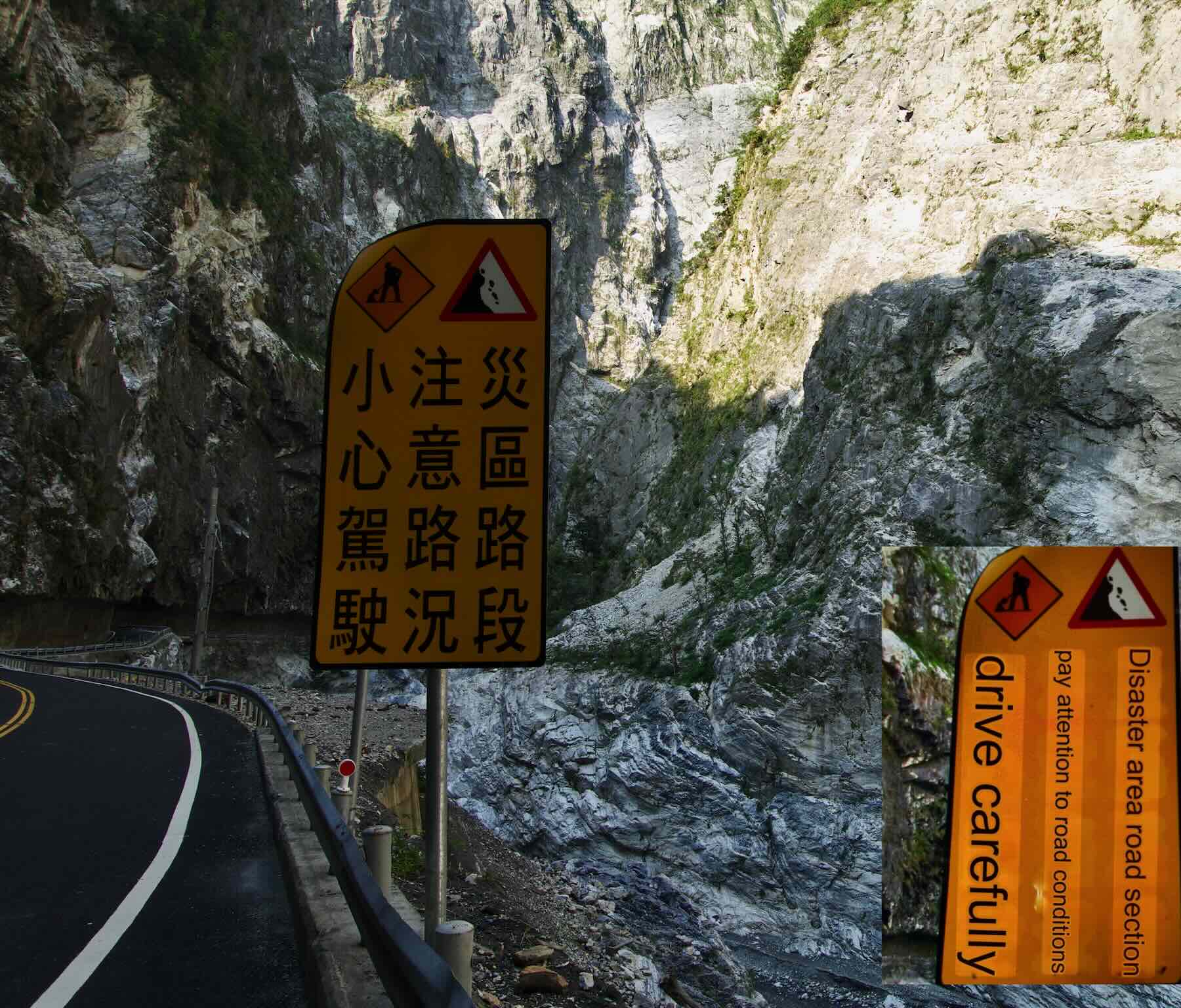
The East Entrance Marker at Taroko National Park. Google Translate provided a quick English translation of the traditional Mandarin! I used the app’s camera feature daily on menus, signs, and all sorts of written text.

east exit from Taroko Park – the entrance road is on the right
————-
Day 14 – Taroko Gorge to Tianxiang / Xincheng Taroko train to Yilan
- date: April 11, 2025
- weather: overcast
- distance: 18 km.
- Ride with GPS File
This morning ride up to Tianxiang and back down to Taroko Village – four hours in all – was one of the most memorable I’ve spent on my Brooks B-17 saddle!
Taroko Gorge is roughly the first 18 kilometres of Highway 8, the Central Cross-Island Highway. This stretch is quite prone to landslides and was badly damaged by the April 2024 Earthquake. In the past year, it has been partially reopened to traffic. However, the hiking trails will undoubtedly remain closed for years as repairs are made.
Our destination was Tianxiang, about 18 km from the east gate pictured above. We crossed the Liwu River on the Jinwen bridge and passed below the Park Visitor Center.


We then headed to the first of several (at least a half dozen) tunnels blasted through the rock. This one was about 850 meters long, and then the road continued over the Shakadang Bridge

map of the east entrance area of Taroko Gorge
Our 7:00 a.m. departure meant traffic was very sparse. The road was clear of rockfall and in excellent shape all the way to Tianxiang. To get a better sense of the nature of the ride, check out this YouTube video by D Stedman – Taiwan Cycling Dec 2025 – Riding Up Taroko Gorge – posted in December 2025. Like our ride, it ends at Tianxiang Village.
Unlike our experience, this cyclist dealt with rain and wet road conditions, as well as much more traffic.
Yet another YouTube upload also has some video of the road from the entrance at Taroko Village to Tianxiang in the first five minutes of her post.
Watching these videos has since led me to get a DJI Action Pro so that I can get similar video views from my bike saddle! Using my iPhone while zipping downhill at 40 km can be unnerving, and out of the question while going uphill!

For the first half of the route, Highway 8 mostly follows the Liwu River, whose headwaters are to the south of marker E on the above map.
The various temples and scenic lookouts are closed and inaccessible from the road. One such was the Eternal Spring shrine that we approached before entering a tunnel section of the road.

Looking up the Liwu river bed to the Eternal Spring shrine

Eternal Springs Shrine – zoomed in


Taroko Gorge road

Google Translates the Taroko road sign!
The road up to Tianxiang is not all uphill; according to the Ride With GPS data, there is about 1500 meters of uphill but also 1100 downhill. Taroko Village is at 60 meters and Tianxiang is at 445, so there is a 385-meter elevation gain over 18 kilometres.

When we weren’t going through tunnels, we were often passing through sections carved out of the outward-facing rock face, as in the image below. One thing I did note is that my GPS track was unable to record my location accurately, especially in the tunnel bu also in other sections of the gorge road. My actual track for the ride up to Tianxiang came out to 22 kilometres!

Taroko – Hwy 8 Gorge section


Tunnel of the nine Turns section

A fellow cyclist emerging from a Taroko tunnel
One of the many points of interest is the Cimu Bridge, aka Motherly Devotion Bridge. We came to it just before passing Jiuqudong (Tunnel of Nine Turns). It was somewhat damaged in the earthquake, but has received a new coat of red paint and the marble lion sculptures at the ends cleaned up.

approaching the Cimu Bridge from the east
The pavilion on the rock outcrop on the far side of the bridge was built by the late Chiang Jing-guo, the only son of Chiang Kai-Chek, in memory of his mother, during the construction of the road.

Motherly Devotion Bridge

Looking down the Gorge from the Cimu Bridge

satellite image of the area from the Cimu Bridge to Tianxiang
Another three kilometres, and a final tunnel section, and we arrived at Tianxiang. It was about 9 a.m., and we were the only visitors there. The massive parking lot of Silk’s Place Taroko Hotel, an upscale hotel, was empty.
However, the restaurant was open, and we ordered some coffee to take out to the patio area on the hotel side.


Tianxiang – community center and hotel to the right
We were all set to start our descent when the Calgary couple arrived. They had left a bit later and were planning to skip the 10 road barrier opening for the next one at 2.

Canadian cyclists at Taroko Gorge, Tianxiang

cyclists at Tienxiang- ready to head back down the gorge
Back over the Zhihua Bridge we went but we did not get far. Just before the entrance to the tunnel was a traffic control barrier and the road was closed. It was 9:45 and wold only be opening at 10. Behind us, a few cars were lined up and waiting.

Zhihui Bridge at Tianxiang
Bridge with the Background of Xiangde Temple Area at the top, close to where we stopped on our way down to wait for the road to reopen


waiting for the Taroko road barrier to be removed

waiting for the Taroko road to reopen
When the road was opened, we waited for a minute to let the line up of vehicles pass by. After that, just as on our ride up the gorge, we had very few vehicles to deal with as we flew down to our hotel – the Liwu Hotel. Taroko.
We had arranged to leave all our gear in our rooms while we did our ride. It added to the enjoyment of our morning ride, since we were pedalling with a load 15 kilograms lighter than usual.

Taroko Park -a Google Earth view of the traffic control barrier at Tianshang post-earthquake

Liwu Hotel front on Hwy 6, Taroko Village
While waiting for the others to get their stuff, I sat on the steps at the front of the hotel. Given her serious look, I was not sure if the cat approaching me was friendly or not. She was soon getting a belly rub!

The Liwu Hotel guard cat
We headed down to the Xincheng Taroko train station to catch a local train heading 82 km up to Yilan. The nice thing about the local – as opposed to the faster levels of service – is that you can just wheel your bike onto the train (specific cars only) instead of having to bag or box it.

looking out the main entrance of the Xincheng Taroko train station

Xincheng Taroko Station – waiting area

The ride to Yilan lasted about 90 minutes. Knowing that we had bypassed some spectacular coastal cycling was made easier to accept thanks to our Taroko ride.

There is an excellent post at the Bike Express Taiwan website dealing with the section of road we avoided. It may tempt you to give it a go!
Cycling the Suhua Highway: Evaluating Challenges, Experiences, and Factors to Consider

looking at my lopsided rear panniers

bikes in the local train to Yilan
We were not the only cyclists in the designated bicycle car. A group of middle school students and their teacher were returning to Taipei after a long weekend spent cycling in the Hualien area.

school group and their bikes
My Yilan hotel was not far from the train station. I checked into my room and was soon on the way to a neighbourhood restaurant. When I told the cashier where I was from, she informed me that she had relatives in Kitchener!
I would come home with a second serving that I would put into the mini-fridge until breakfast time.

bike in my room at the Yilan hotel
————-
Day 15 – Yilan to Jiufen
- date: Saturday, April 12, 2025
- weather: overcast
- distance: 78 km.
- Ride with GPS File
It was 8:15 on a Saturday when I set off from downtown Yilan. It was early enough that I avoided the later traffic as I cycled through urban streets to access Highway 2 and the coast route. It took about an hour.
I would spend the rest of the day cycling a mostly flat route along Highway 2, along with the occasional bike path. The day would end with the most intense climb of the entire bike ride around the island – 300 meters of altitude gain in less than 5 kilometres!

Taiwan – Provincial Hwy 2
While I was occasionally shocked by the volume of heavy truck traffic on Hwy 2, scenes like the ones in the images below compensated.


Guishan Island off Taiwan’s NE coast

Guishan Island off Taiwan’s NE coast

bike lane on the road NE Taiwan road

bike lane off Hwy 2 north of Toucheng

Mostly, the traffic was fairly light even when I cycled through built-up areas like Toucheng Township, where I stopped to get a photo of Qingyun Temple, dedicated to the Jade Emperor, in Shicheng Village. I really should have taken some time to visit the temple grounds.

A bit further along, I passed through a village with a crowded fish market. That may explain the lineup of cars in the photo I took as I looked back.

I also managed to lose my way this day. Not registering the blue and white bike route marker on the ground or the significance of the vertical post, I headed instead down a dirt path for about 100 meters. My realization that something was not right coincided with the abrupt end of the path – I headed back the way I had come and saw the markers in the image below!

The missed bike route sign up the alley

shore near Toucheng, Taiwan – not the bike route!

Back on track, I continued along Hwy 2 to the NE corner of the island, amazed at how scenic the day’s ride had been.

Harbour – Gangliao District, Taiwan

break time off Taiwan Hwy 2 N coast

Hwy 2 and harbour – Taiwan NE corner

NE corner of Taiwan – the map below shows the location


Hwy 2 view looking east

roadway along Taiwan’s NE coast

on the way to Jiufen
By 3, I was at the bottom of the road to Jiufen and my room for the night in a guesthouse off Jishan Street, sitting at the top of the most intense one hour of cycling of my entire 1000 kilometres around the island! Somehow it got done, but it did involve me getting off the bike and pushing it for stretches because of the steepness of the road. Note: the next morning, I was rewarded with an equivalent descent!

Jiufen was an unexpected treat, a dynamic spot where I could easily have spent a couple of days taking in the sights and temples and overall energy.

a view from Jiufen man street

a view from my Jiufen hotel


Jiufen vegan food stall – all vegan!

Jiufen Lane with shops
Day 16 – Jiufen to Taipei
- date: Sunday, April 13 2025
- weather: overcast
- distance: 51 km.
- Ride With GPS link
I was up and out shortly after dawn on this Sunday morning in Jiufen. The streets were empty, and the shops were closed. I was on my way to the town’s major temple – the Chenhuang Temple – which was a winding street down from my accommodation.
While Part 1 of my Taiwan trip report featured pics from a dozen temple visits, once I got to the east coast, the temples seem to have been replaced by images of food bowls! The Chenhuang Temple was my chance to address the imbalance. There were yet more to explore in Jiufen, but I had run out of time for more than one.

Chenhuang Temple Jiufen from the street above


The main entrance of the Chenhuang Temple


My too-brief visit over, I headed back to my room and packed my panniers. The room was so small that to open the door to the hallway, I had to push the bike into the bathroom. Out went the panniers and then came the bike. I was on my way.


Jufen room – the most cramped and expensive of the entire trip
The last day on the bike! It was a Sunday, and I had to return the bike to Matthew bike Shop in Taipei by 5:00 p.m. My flight back to Toronto was the next day, so I was definitely feeling end-of-trip vibes as I set off.
The guesthouse included breakfast as part of the deal. That is a peanut butter sandwich you see on the stone ledge; it came with a cup of black coffee. Luckily,. I had stocked up at the 7-Eleven across the street the evening before

breakfast in Jiufen
The day’s route mostly followed the Keelung River all the way to Taipei and the Shilin District, where the bike shop was located. As the elevation profile shows, the ride was an easy one, especially once I hooked into the river bike path around Km 30. And what a way to start the day – 240 meters of descent in the first 3 km!

day 16 aelevatin chart

empty road east of Jiufen

on my way to Taipei on a Sunday morning


shipping containers closer up
Taipei 101 is an iconic building, the equivalent of what the CN Tower is for Torontonians. It too briefly held the title of the world’s tallest building!
While I had spent three nights in Taipei at the beginning of my visit, I had not gone far enough east to see it. Now, as I cycled along the Keelung about 20 km from the end, there it was.

first view of Taipei 101

Keelung (Jilong) River bike path map

the last 20 km of my bike ride – flat and stress free along Keelung River bike paths

heading west on the Keelung River bike path

Looking back at Taipei 101 from the Keelung River bike path

Keelung R dock with small watercraft
The canoe tripper in me honed in on the two derelict Old Town canoes on the boat ramp, their backs filled with water. It was a long way from the manufacturing plant in Maine where they had been built.

Old Town canoes on the Keelung River in Taipei
I stopped under the bridge, not more than 200 meters from MatthewBike Shop. My iPhone battery had run out, and I connected it to the power bank to bring it back to life. I would need it for my return to the Papa Whale Hotel in Ximending District after I dropped off the bike.

locals playing a board game under the Shilin Bridge
While I was returning the bike and relaed gear, I chatted with a German woman who was taking possession of a rental ebike for her own Taiwan adventure. She was an airline stewardess and had one week to explore a little bit of the island.

Screenshot
Matthewbike gets rave reviews online, which is how I found the shop. The Surly Disk Trucker I rented for 16 days cost me about $350.CDN (7500 NT$).
And then the focus turned back to food! After three days in Taipei, i ad already found a couple of favourte place so off I went.

an all-vegan menu in Ximending

my first course – classic fries and veg topping

a last afternoon in Ximending

veg buffet in Taipei Ximending
Taiwan proved to be an excellent choice for my bike ride. The ride itself was fun, and I learned a lot along the way.
- The roads were, for the most part, fantastic, especially on the East Coast. While it is not all bike path, it is manageable. [The West Coast had its exceptions!]
- The people, while reserved, were friendly and always helpful.
- My feeble attempt at learning Mandarin – three months of online lessons – proved unnecessary but was still worth the effort. What I learned was basic Pinyin, one key to pronouncing Chinese words correctly. The other key is learning to distinguish among the four tones a syllable may have.
- Many people, especially the younger ones, speak some English. Knowing a few essential Mandarin phrases and how to count is the least a visitor can do Zǎo! xièxiè, qing wen send the right signal.

I chose the Yoyo Chinese yearly option; The monthly plan would have been enough. So too is making use of the free YouTube videos offered by Yoyo Chinese and other content creators. And just as important as the language is learning a bit about the history and politics of Taiwan to help you understand what you are seeing.
————-
環島 Huándǎo – Planning A Bicycle Ride Around Taiwan (Route, Bike Rental, Accommodation, Etc.)