
- The Route Map
- The Lake To Lake Trail
- Getting To Bradford – The GO Train
- Getting To the Trailhead
- The Nokiidaa Trail To Bayview Ave S of Vandorf Sideroad
- The Meaning of the Anishnaabe Word Nokiidaa
- Down Leslie Street to John Street
- Upper Don Trail
- More Ride Possibilities Thanks To GO Train
—————
The Route Map

Bradford GO Station to Toronto Riverdale
Click the map image to open the Ride with GPS webpage and download the route file in various formats.
—————
The Lake To Lake Trail
These mini bike adventures provide a few hours of mostly Zone 2 exercise. They also get me to look more closely at the dozens of villages, towns, cities, townships, and other designated communities. I have never taken the time to pinpoint their locations before! Nothing like bicycling through them to pay a bit more attention to the names on the map. The top 2/3s of this ride is within York Region; the bottom third is within the City of Toronto.

York Region with various townships, towns, cities, etc.
The entire trail – from Lake Simcoe to Lake Ontario – now has the name Lake To Lake Trail. The overview map below shows the trail, along with various east-west trails which cross it in the York Region section. The Trail starts at Cooks Bay and ends at Cherry Beach in the newly reconstructed Don River estuary.

York Region Section
The entire York Region Map Set (Georgina to East Gwillimbury down to Aurora South), can be accessed here.
The York Region section has a new overall name – the Nokiidaa Trail, which includes the pre-existing trails, including
- The Tim Jones Trail
- The Tom Taylor Trail
- The Klaus Wehrenberg Trail north of Vandorf Road
City of Toronto Section
Once you reach the northern boundary of the City of Toronto at Steeles Avenue, you enter the Don River Trail network, which starts at Leslie just south of Steeles. It takes you all the way down to Lake Ontario, though there are sections where you are on roads with traffic.
While the Betty Sutherland Trail takes you from Sheppard Avenue under the 401 to Valleybrook Road, the trail’s 50-meter section under Hwy 401 is officially closed until 2026. A detour via Don Mills Road is the temporary solution.
Access the entire City of Toronto Trail Map here.
—————
Getting To Bradford – The GO Train
Since I live within 5 km of Union Station in Toronto, I cycled there to access the starting point via the GO Train.
GO Train runs one train up to Barrie each weekday morning at 9:54 from Union Station. GO makes bike transport hassle-free; most cars have designated bicycle storage at each end.

Union Stn – Allandale stops and times
If you live up near Bradford, you could park your vehicle at either the Bradford or East Gwillimbury GO stations, cycle down to Cherry Street in Toronto and then along the Waterfront Trail west to Union Station. There is a GO train which heads up to Barrie each Saturday and Sunday at 17:54. Train service is more frequent during the week. See here for some of the scheduled departures.

Bradford GO Station platform
—————
Getting To The Trailhead

Screenshot
From the Bradford GO station, I cycled on Bridge Street over the Holland River. The road then changes names to Hwy 1; I stuck with it when I missed the turn onto Hwy 83. This initial bit of riding was the least enjoyable of the entire day. It was midday, with heavy traffic on a major local artery.
See this Google Maps view of a better approach to access the trailhead from Bradford GO.
When I do this ride again in October for the fall colours, I am just going to get off at the East Gwillimbury Go Station, one stop before Bradford GO Station. The time saved by getting off one stop early, I will spend cycling up to the trailhead on Mt. Albert Road, which is a terrific intro to the Nokiidaa Trail.
—————
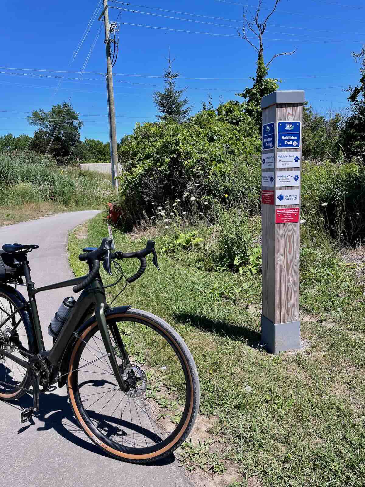
The Nokiidaa Trail

The Nokiddaa Trail begins at the corner of Mt. Albert Road and Yonge Street and takes you down the north part of the York Region section of the Lake To Lake Trail. It ends on Bayview north of Bloomington Road.

YouTube video –
The trail is mostly a fine but packed own gravel, with asphalt stretches the second most common. Wooden boardwalks through some marshlands and 80 meters of natural dirt trail near the end of the trail in Aurora made up the rest of the Trail.
A few roads need to be crossed to access the Trail continuation. Trail signs help keep you on the right track. On occasion, side trails and paths leading to residential areas can leave you confused and wondering if you made the right choice!

To download the entire York Region Map Set in PDF (Georgina to East Gwillimbury down to Aurora South), click on the map image above or here.

Rogers Conservation Area bike trail

East Holland River – Rogers Conservation Area
Nokiidaa Trail south of Green Line
Nokiidaa – Meaning
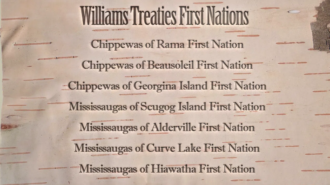
The word Nokiidaa is Anishinaabe in origin and means “let’s all work together”.Its choice was meant as a gesture of reconciliation with the descendants of the Ojibwe families whose hunting grounds once included the Holland River valley. They had moved into southern Ontario from their Georgian Bay homeland in the late 1600s following their victory over the Haudenosaune (i.e., the Upper New York State Iroquois or Five Nations). Before them, it had been the Wendat, an Iroquoian People, who had occupied the land for hundreds of years.
The nearest First Nation is the Chippewas of Georgina Island. In 2018, Georgina F.N. and six others impacted by the Williams Treaties reached a final agreement on a revised treaty, settling litigation over land surrenders and harvesting rights. The Seven affected First Nations also received $1.1 billion.

Williams Treat First Nations
In 2022, Nokiidaa was also chosen to replace John A. Macdonald as the name of a public school in Markham. The Scotland-born political leader was most responsible for creating the political entity we know as Canada. He was also Canada’s first Prime Minister. His support for residential schools is the reason given for the name change.

Trail etiquette sign – N side of Davis Drive

Tom Taylor sign just south of Mulock Drive

trail through marsh near Yonge: St. John’s Sideroad
Most of the route is framed by Yonge Street on the west and Leslie Street on the east. At St. John’s Sideroad, the trail passes very close to Yonge Street. Only the stretch from Leslie/Sheppard to Leslie/Eglinton strays east of Leslie Street.

trqail sign between St John’s Sideroad and Wellington St.E in Aurora

trail choices N of Wellington St. E
The two images immediately below show the only natural dirt section of the route. It was less than 100 meters long.

dirt trail in Aurora N of Vandorf Rd.

trail just N of Vandorf aurora
Lots of trail names encountered – they occasionally had me wondering which one to choose. I consulted the Ride With GPS map on my iPhone more than once!

gravel trail just N of Vandorf Road, Aurora

trail entrance at Vandorf, north side
—————
Down Leslie Street to John Street
Once on Bayview, the Nokiidaa Trail ride is over. From here to Leslie Street, just south of Steeles Avenue, 24 kilometres of designated bike lanes and bike paths make for stress-free riding.
Down Bayview and over to Leslie is about four kilometres; then it is 20 down to Steeles Avenue, the boundary between York Region and the City of Toronto.

Vandorf to Bayview to Leslie
While I accessed Leslie Street via Bloomington Road. I am not sure if this is the Lake To Lake Route, or if the plan is to continue further down Bayview to Stouffville Road before deking over to Leslie.

Leslie Street: Hwy 7 – bike path
At Leslie and John Street, the route heads west to access the trail through German Mills Meadow.

Leslie/John access to the trail

trail continuation south of John St., west of Leslie
—————
Upper Don Trail + Betty Sutherland Trail
The trail through German Mills Meadow comes out on Leslie, just north of Steeles Avenue. The Upper Don Trail begins on the west side of Leslie Street about 200 metres south of Steeles.

Leslie Street/Steeles Avenue trail continuation
This 25-kilometre section of the day’s ride – up to and then back down to Toronto’s Riverdale neighbourhood – is one I’ve done at least 100 times over the years. It is a great ride, and doing it on a weekday, especially in the morning, makes it quite likely you will have the path almost to yourself.
See this trip report for more details –
One Current Complication
In April 2023, the Betty Southerland Trail was broken in two. While you can cycle down the northern part from Sheppard/Leslie, you cannot access the southern part. The reason: intermittent work for the past 2 1/2 years has blocked the Hwy 401 underpass path.
This has required a detour via Havenbrook Blvd to Don Mills Road and then out over the 401 to Duncan Mill Road, where you get to cycle past the south end of the Sutherland Trail.
On the weekday afternoon that I came down the trail from Sheppard, an approaching cyclist from the underpass noted that he and other cyclists had been using holes in the fences to access the path continuation on occasions when there were no workers on site. This was the case the afternoon I passed through.
The expected route is Havenbrook to Don Mills Road, then south over the 401 to Duncan Mill Road.

401 – Sutherland Trail north end

The Betty Sutherland Trail – officially closed but…
The official reopening of the trail is scheduled for sometime in 2026, so until then, impatient walkers and cyclists will likely continue removing the barriers to the trail. The lack of any sense of urgency to get the job done and reopen the path is puzzling.

Under the 401 – Sutherland Trail
Once south of the 401 and on Duncan Mill Road, it is south to York Mills Road, where a designated bike lane takes you over the bridge and to the north end of the Don Mills Rail Trail.

See the trip report mentioned above for more details on the ride from the 401 down to Pottery Road, Riverdale, and points beyond!
All in all, a most enjoyable way tos spend four hours without needing to use my Garmin Varia device. An October repeat, when the fall colours add extra drama to the park trails, is on my to-do list!
—————
This YouTube video, posted by Bike Ride Beats in September 2024, will give you an excellent idea of the trail surfaces and conditions you will see on your own version of the Lake To Lake ride:
—————
More Ride Possibilities Thanks To GO!

The GO Train network opens up southern Ontario for cyclists looking for new pavement or gravel to ride. In an hour or two from downtown Toronto, you can be in Oshawa, Barrie, Kitchener, Burlington, or Niagara Falls. Here are a couple of rides I’ve done –
Off-Road Bike Trails From Oshawa Go Station To Toronto Riverdale